Doncaster
§ This page gives an overview of the Doncaster local authority district, bringing together key facts, maps, and data to help you quickly understand the area. This is one of 361 LAD profiles on Baseview.
Overview ⁞ Doncaster is a metropolitan borough in South Yorkshire, centred on the historic market town of the same name. Known for its strong railway heritage and long association with horse racing, the area blends urban living with extensive green spaces and surrounding villages. Doncaster’s economy is shaped by logistics, manufacturing, and aviation, supported by its strategic position on major road and rail networks. Key attractions include Doncaster Racecourse, Yorkshire Wildlife Park, and the Georgian mansion at Cusworth Hall. Recent regeneration projects have revitalised the town centre with new housing, retail, and cultural spaces. With a mix of heritage, modern development, and excellent connectivity, Doncaster serves as a lively hub for work, travel, and leisure in the wider Yorkshire region.
What County is Doncaster in?
Doncaster is in the ceremonial county of South Yorkshire, in the Yorkshire and the Humber region of England. It is governed by Doncaster Metropolitan Borough Council, which operates as a unitary authority responsible for local government services across the borough. For official, ceremonial, and geographic purposes, Doncaster is part of South Yorkshire.
Historically, Doncaster was part of the West Riding of Yorkshire until local government reforms in 1974 created the metropolitan county of South Yorkshire. Although historic references may still associate Doncaster with the West Riding, the correct modern answer is that Doncaster is in South Yorkshire.
Doncaster Boundary Map
This map shows the official boundary of the Doncaster local authority district, based on the latest geographic data published by the Office for National Statistics (ONS). It provides a clear view of the district’s extent and helps you understand how the area fits within the wider regional and national landscape.
Contains OS data © Crown copyright and database right 2025. Source: Office for National Statistics licensed under the Open Government Licence v3.0.
The administrative boundary of Doncaster can also be viewed on OpenStreetMap: District Boundary of Doncaster.
Key Facts about Doncaster
What region is Doncaster in? Doncaster is in the Yorkshire and The Humber of England, a region within the UK.
What county is Doncaster in? Doncaster is located in the county of South Yorkshire.
Is Doncaster a city? Yes, Doncaster is a city. Doncaster holds official city status as one of the 76 designated cities in the UK.
Who governs Doncaster? The local government for this district is: City of Doncaster Council (Metropolitan District).
▶ Official website of City of Doncaster Council 🔗 doncaster.gov.uk
Which police force covers Doncaster? Policing in Doncaster is provided by South Yorkshire Police 🔗 southyorkshire.police.uk, which serves 4 local authority districts: Barnsley ⁞ Doncaster ⁞ Rotherham ⁞ Sheffield.
Doncaster in International Geographies
In the International Territorial Levels (ITLs) hierarchy, Doncaster is an ITLs Level 3 area:
- (ITL 1) Yorkshire and The Humber
- (ITL 2) ⇒ South Yorkshire
- (ITL 3) ⇒⇒ Doncaster
The International Territorial Levels are used by OECD member countries for statistical purposes to classify administrative areas. We have this listable page for easy browsing of ITL names and codes: International Territorial Levels.
Constituencies in Doncaster
Doncaster is divided into 4 parliamentary constituencies, listed below in alphabetical order.
A constituency is a specific geographical area that elects one Member of Parliament (MP) to represent them in the House of Commons. The United Kingdom is divided into 650 parliamentary constituencies, 54 of them are in Yorkshire and the Humber region. We have this list page for easy browsing of all UK parliamentary constituencies: List of Constituencies.
Wards in Doncaster
Doncaster is divided into 21 wards, listed below in alphabetical order.
- Adwick le Street & Carcroft
- Armthorpe
- Balby South
- Bentley
- Bessacarr
- Conisbrough
- Edenthorpe & Kirk Sandall
- Edlington & Warmsworth
- Finningley
- Hatfield
- Hexthorpe & Balby North
- Mexborough
- Norton & Askern
- Roman Ridge
- Rossington & Bawtry
- Sprotbrough
- Stainforth & Barnby Dun
- Thorne & Moorends
- Tickhill & Wadsworth
- Town
- Wheatley Hills & Intake
In the UK, a ward is a subdivision of a local authority area, used mainly for electoral and statistical purposes. Defined by the ONS, wards represent the primary unit for local elections, each returning one or more councillors to the local council. Wards are also used as a key geography for presenting population and census data. We have this list page for easy browsing of all electoral wards: List of all Electoral Wards in the UK.
Parishes in Doncaster
Doncaster is part-parished: 43 civil parishes (listed A-Z below) alongside 3 unparished areas.
- Adwick upon Dearne
- Armthorpe
- Askern
- Auckley
- Austerfield
- Barnburgh
- Barnby Dun with Kirk Sandall
- Bawtry
- Blaxton
- Braithwell
- Brodsworth
- Burghwallis
- Cadeby
- Cantley
- Clayton with Frickley
- Conisbrough Parks
- Denaby
- Edenthorpe
- Edlington
- Fenwick
- Finningley
- Fishlake
- Hampole
- Hatfield
- Hickleton
- High Melton
- Hooton Pagnell
- Kirk Bramwith
- Loversall
- Marr
- Moss
- Norton
- Owston
- Rossington
- Sprotbrough and Cusworth
- Stainforth
- Stainton
- Sykehouse
- Thorne
- Thorpe in Balne
- Tickhill
- Wadworth
- Warmsworth
A civil parish is the lowest tier of local government in England, used for villages, small towns, and suburbs. They have their own local authority, either a parish council or a parish meeting, which provides local services like managing parks, allotments, and streetlights, and represents the community's views to larger councils.
We have this list page for easy browsing of all parishes: List of Civil Parishes in England and Wales.
Post Towns in Doncaster
Below is a list of post towns in Doncaster, grouped by postcode area:
- DN ▸ Doncaster (DN1 / DN2 / DN3 / DN4 / DN5 / DN6 / DN7 / DN8 / DN9 / DN10 / DN11 / DN12 / DN55)
- S ▸ Mexborough (S64)
The UK postal hierarchy begins with broad postcode areas (such as “CB” or “M”), which are divided into smaller postcode districts (such as “CB8” or “M1”) to support accurate mail routing. Each postal address is anchored by a designated post town, the official locality name used in the UK postcode system, which operates independently from Local Authority Districts —the administrative boundaries used for council tax and local government services. Because they serve different purposes, a property’s postal address and its local authority district do not always align exactly.
Built-up Areas in Doncaster
Doncaster covers 46 built-up areas, listed below in alphabetical order.
- Adwick le Street
- Arksey
- Armthorpe
- Askern
- Auckley
- Austerfield
- Barnburgh and Harlington *
- Barnby Dun
- Bawtry *
- Bentley (Doncaster)
- Blaxton
- Bolton upon Dearne *
- Braithwell
- Branton
- Campsall
- Conisbrough *
- Denaby Main
- Doncaster
- Dunscroft and Hatfield
- Finningley
- Fishlake
- Goldthorpe *
- Harworth and Bircotes *
- Hatfield Woodhouse
- Hellaby *
- High Melton
- Kirk Sandall and Edenthorpe
- Kirk Smeaton and Little Smeaton *
- Maltby *
- Mexborough *
- Moorends
- Moss
- New Rossington and Rossington
- Norton (Doncaster)
- Scawthorpe and Cusworth
- Sprotbrough
- Stainforth
- Stainton (Doncaster)
- Swinton (Rotherham) *
- Thorne
- Thurnscoe *
- Tickhill
- Toll Bar
- Wadworth
- Warmsworth
- Wroot *
In the UK, a Built-up Area (BUA) is a continuous urban area of at least 20 hectares (0.2 km²), defined by the ONS as land where buildings are generally no more than 200 metres apart, such as towns, cities, or large villages. (Note: A BUA name marked with an asterisk (*) indicates that the area is situated partly in the district of Doncaster.)
We have this list page for easy browsing of all built-up areas: List of all Built-up Areas in GB.
Railway Stations in Doncaster
Doncaster is served by a number of National Rail stations, providing rail connections to nearby towns, cities, and destinations across Great Britain. The railway stations listed below are located within the Doncaster Local Authority District and are grouped by train operating company for clarity.
- London North Eastern Railway ▸ Doncaster (DN1 1PE)
- Northern Trains ▸ Thorne North (DN8 4HZ) ⁞ Adwick (DN6 7AJ) ⁞ Mexborough (S64 9AQ) ⁞ Bentley (South Yorkshire) (DN5 0BE) ⁞ Conisbrough (DN12 3DX) ⁞ Kirk Sandall (DN3 1LL) ⁞ Hatfield and Stainforth (DN7 4EQ) ⁞ Thorne South (DN8 5QN)
This is a district-level view only. For a complete list of all National Rail stations across Great Britain, see the UK National Rail Stations Directory.
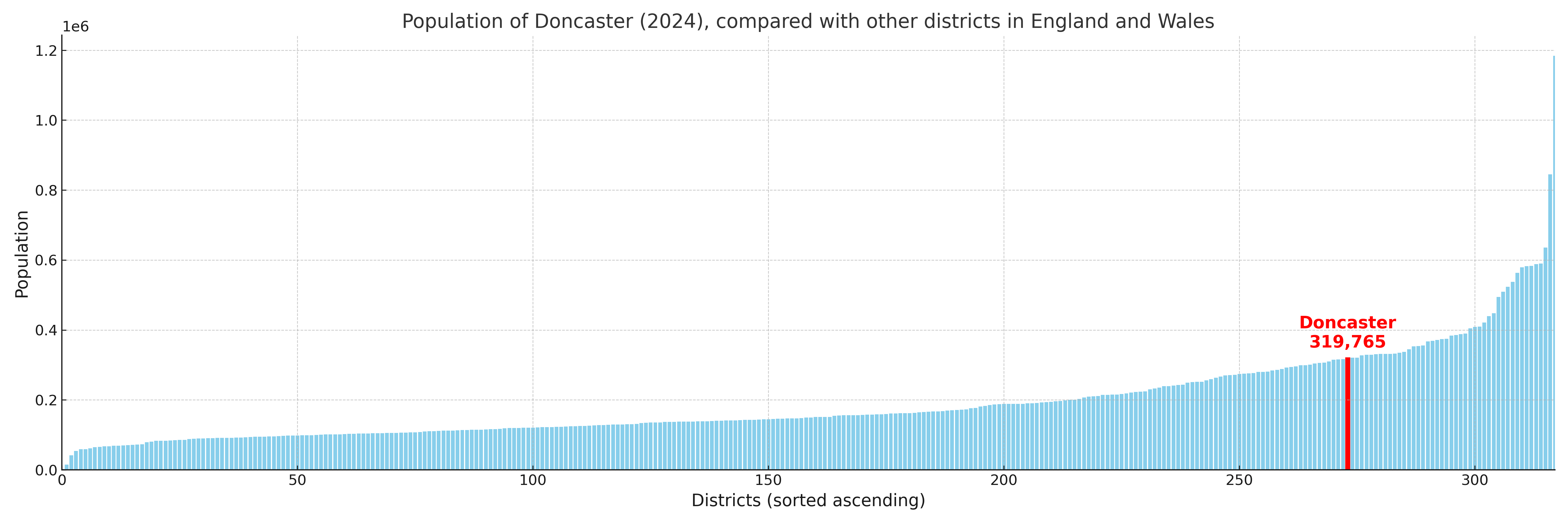
Doncaster compared with other districts in the UK
This section shows how Doncaster compares with other local authority districts in the UK, using a variety of measures and rankings.
Doncaster has 21 electoral wards.

Doncaster has a population of 319,765 (2024 mid-year estimate by ONS)
Population and Migration Trends in Doncaster
This chart shows the population trend for Doncaster from 2015 to 2024. It provides a quick overview of whether the local authority is growing, stable, or declining over time, and helps set context for the migration patterns shown below.
Population change is influenced by natural change (births minus deaths) and migration. The net migration chart below focuses on migration, separating internal migration (moves within the UK) from international migration (moves to and from abroad). Positive values indicate net inflows, while negative values indicate net outflows. The rate labels (per 1,000 residents) help compare migration intensity across years, even when the population size changes.
More local statistics and data for Doncaster can be found on the ONS statistics for Doncaster.
Latest news about Doncaster
Use the search box, or suggested search phrases, below to find recent news, council updates, planning stories, housing developments, transport changes, public services news, local elections, community issues and other local developments related to Doncaster. Results may include coverage from UK national, regional and local news websites, as well as official public-sector and local democracy sources.
- Doncaster council
- Doncaster planning
- Doncaster local elections
- Doncaster housing
- Doncaster transport
- Doncaster regeneration
- Doncaster public services