West Northamptonshire
§ This page gives an overview of the West Northamptonshire local authority district, bringing together key facts, maps, and data to help you quickly understand the area. This is one of 361 LAD profiles on Baseview.
Overview ⁞ West Northamptonshire covers a diverse landscape in the heart of England, stretching from the rolling uplands of the Cotswolds’ eastern fringes to the River Nene valley. Northampton is the largest town, known for its historic market square, churches such as All Saints, and cultural venues alongside modern shopping districts. Daventry lies to the west, with access to the Grand Union Canal and surrounding countryside, while Towcester adds Roman heritage and proximity to Silverstone Circuit, a world-famous motor racing venue. The district includes many villages with stone cottages, medieval churches, and countryside settings, while reservoirs such as Pitsford and canals provide outdoor recreation. Its geography combines river valleys, farmland, woodlands, and historic settlements, giving it both urban vibrancy and rural charm.
West Northamptonshire Boundary Map
This map shows the official boundary of the West Northamptonshire local authority district, based on the latest geographic data published by the Office for National Statistics (ONS). It provides a clear view of the district’s extent and helps you understand how the area fits within the wider regional and national landscape.
Contains OS data © Crown copyright and database right 2025. Source: Office for National Statistics licensed under the Open Government Licence v3.0.
The administrative boundary of West Northamptonshire can also be viewed on OpenStreetMap: District Boundary of West Northamptonshire.
Key Facts about West Northamptonshire
What region is West Northamptonshire in? West Northamptonshire is in the East Midlands of England, a region within the UK.
What county is West Northamptonshire in? West Northamptonshire is in the county of Northamptonshire.
Is West Northamptonshire a city? No, West Northamptonshire is not a city. (Note: the UK has 76 officially designated cities.)
Who governs West Northamptonshire? The local government for this district is: West Northamptonshire Council (Unitary Authority).
▶ Official website of West Northamptonshire Council 🔗 westnorthants.gov.uk
Which police force covers West Northamptonshire? Policing in West Northamptonshire is provided by Northamptonshire Police 🔗 northants.police.uk, which serves 2 local authority districts: North Northamptonshire ⁞ West Northamptonshire.
West Northamptonshire in International Geographies
In the International Territorial Levels (ITLs) hierarchy, West Northamptonshire is an ITLs Level 3 area:
- (ITL 1) East Midlands
- (ITL 2) ⇒ Leicestershire, Rutland and Northamptonshire
- (ITL 3) ⇒⇒ West Northamptonshire
The International Territorial Levels are used by OECD member countries for statistical purposes to classify administrative areas. We have this listable page for easy browsing of ITL names and codes: International Territorial Levels.
Constituencies in West Northamptonshire
West Northamptonshire is divided into 4 parliamentary constituencies, listed below in alphabetical order.
A constituency is a specific geographical area that elects one Member of Parliament (MP) to represent them in the House of Commons. The United Kingdom is divided into 650 parliamentary constituencies. We have this list page for easy browsing of all UK parliamentary constituencies: List of Constituencies.
Wards in West Northamptonshire
West Northamptonshire is divided into 31 wards, listed below in alphabetical order.
- Abington and Phippsville
- Billing and Rectory Farm
- Boothville and Parklands
- Brackley
- Braunston and Crick
- Brixworth
- Bugbrooke
- Castle
- Dallington Spencer
- Daventry East
- Daventry West
- Deanshanger
- Delapre and Rushmere
- Duston East
- Duston West and St. Crispin
- East Hunsbury and Shelfleys
- Hackleton and Grange Park
- Headlands
- Kingsthorpe North
- Kingsthorpe South
- Long Buckby
- Middleton Cheney
- Moulton
- Nene Valley
- Riverside Park
- Silverstone
- Sixfields
- St. George
- Talavera
- Towcester and Roade
- Woodford and Weedon
In the UK, a ward is a subdivision of a local authority area, used mainly for electoral and statistical purposes. Defined by the ONS, wards represent the primary unit for local elections, each returning one or more councillors to the local council. Wards are also used as a key geography for presenting population and census data. We have this list page for easy browsing of all electoral wards: List of all Electoral Wards in the UK.
Parishes in West Northamptonshire
West Northamptonshire is fully parished: 166 civil parishes, listed A-Z below.
- Abthorpe
- Adstone
- Alderton
- Althorp
- Arthingworth
- Ashby St Ledgers
- Ashton
- Aston le Walls
- Aynho
- Badby
- Barby
- Billing
- Blakesley
- Blisworth
- Boddington
- Boughton
- Brackley
- Bradden
- Brafield on the Green
- Braunston
- Brington
- Brixworth
- Brockhall
- Bugbrooke
- Byfield
- Canons Ashby
- Castle Ashby
- Catesby
- Chacombe
- Charwelton
- Chipping Warden and Edgcote
- Church with Chapel Brampton
- Clay Coton
- Clipston
- Cogenhoe and Whiston
- Cold Ashby
- Cold Higham
- Collingtree
- Cosgrove
- Cottesbrooke
- Courteenhall
- Creaton
- Crick
- Croughton
- Culworth
- Daventry
- Deanshanger
- Denton
- Dodford
- Draughton
- Duston
- East Farndon
- East Haddon
- East Hunsbury
- Easton Neston
- Elkington
- Evenley
- Everdon
- Eydon
- Far Cotton and Delapre
- Farthinghoe
- Farthingstone
- Fawsley
- Flore
- Gayton
- Grafton Regis
- Grange Park
- Great Houghton
- Great Oxendon
- Greatworth and Halse
- Greens Norton
- Guilsborough
- Hackleton
- Hannington
- Hardingstone
- Harlestone
- Harlestone Manor
- Harpole
- Hartwell
- Haselbech
- Hellidon
- Helmdon
- Hinton-in-the-Hedges
- Holcot
- Holdenby
- Hollowell
- Hunsbury Meadows
- Kelmarsh
- Kilsby
- Kings Sutton
- Kingsthorpe
- Kislingbury
- Lamport
- Lilbourne
- Litchborough
- Little Houghton
- Long Buckby
- Maidford
- Maidwell
- Marston St Lawrence
- Marston Trussell
- Middleton Cheney
- Milton Malsor
- Moreton Pinkney
- Moulton
- Naseby
- Nether Heyford
- Newbottle
- Newnham
- Northampton
- Norton
- Old
- Old Stratford
- Overstone
- Overthorpe
- Pattishall
- Paulerspury
- Pitsford
- Potterspury
- Preston Capes
- Quinton
- Radstone
- Ravensthorpe
- Roade
- Rothersthorpe
- Scaldwell
- Shutlanger
- Sibbertoft
- Silverstone
- Slapton
- Spratton
- Stanford
- Staverton
- Stoke Bruerne
- Stowe IX Churches
- Sulby
- Sulgrave
- Syresham
- Thenford
- Thornby
- Thorpe Mandeville
- Tiffield
- Towcester
- Upper Heyford
- Upton
- Walgrave
- Wappenham
- Warkworth
- Watford
- Weedon Bec
- Welford
- Welton
- West Haddon
- West Hunsbury
- Weston and Weedon
- Whilton
- Whitfield
- Whittlebury
- Wicken
- Winwick
- Woodend
- Woodford cum Membris
- Wootton
- Yardley Gobion
- Yardley Hastings
- Yelvertoft
A civil parish is the lowest tier of local government in England, used for villages, small towns, and suburbs. They have their own local authority, either a parish council or a parish meeting, which provides local services like managing parks, allotments, and streetlights, and represents the community's views to larger councils.
We have this list page for easy browsing of all parishes: List of Civil Parishes in England and Wales.
Post Towns in West Northamptonshire
Below is a list of post towns in West Northamptonshire, grouped by postcode area:
- NN ▸ Brackley (NN13) ⁞ Daventry (NN11) ⁞ Northampton (NN1 / NN2 / NN3 / NN4 / NN5 / NN6 / NN7) ⁞ Towcester (NN12)
The UK postal hierarchy begins with broad postcode areas (such as “CB” or “M”), which are divided into smaller postcode districts (such as “CB8” or “M1”) to support accurate mail routing. Each postal address is anchored by a designated post town, the official locality name used in the UK postcode system, which operates independently from Local Authority Districts —the administrative boundaries used for council tax and local government services. Because they serve different purposes, a property’s postal address and its local authority district do not always align exactly.
Built-up Areas in West Northamptonshire
West Northamptonshire covers 103 built-up areas, listed below in alphabetical order.
- Ashton (West Northamptonshire)
- Aston le Walls
- Aynho
- Badby
- Banbury *
- Barby
- Blakesley
- Blisworth
- Boughton (West Northamptonshire)
- Brackley
- Brafield-on-the-Green
- Braunston
- Brixworth
- Bugbrooke
- Byfield
- Chacombe *
- Chapel Brampton
- Charlton (West Northamptonshire)
- Chipping Warden
- Church Brampton
- Clipston
- Cogenhoe
- Collingtree and Milton Malsor
- Cosgrove *
- Cottesbrooke
- Creaton
- Crick
- Croughton
- Culworth
- Daventry
- Deanshanger
- Denton (West Northamptonshire)
- East Farndon
- East Haddon
- Edgcote
- Evenley
- Eydon
- Farthinghoe
- Flore
- Gayton (West Northamptonshire)
- Great Houghton (West Northamptonshire)
- Greatworth
- Greens Norton
- Grendon (North Northamptonshire) *
- Guilsborough
- Hackleton
- Harpole
- Hartwell
- Helmdon
- Hinton-in-the-Hedges
- Horton (West Northamptonshire)
- Kilsby
- Kings Sutton
- Kislingbury
- Little Houghton
- Long Buckby
- Long Buckby Wharf
- Lubenham *
- Maidwell
- Market Harborough *
- Mawsley Village *
- Middleton Cheney
- Milton Keynes *
- Moreton Pinkney
- Moulton (West Northamptonshire)
- Naseby
- Nether Heyford
- Newnham (West Northamptonshire)
- Northampton *
- Old Stratford *
- Onley
- Pattishall and Astcote
- Paulerspury
- Piddington (West Northamptonshire)
- Pitsford
- Potterspury
- Radstone
- Ravensthorpe
- Roade
- Rothersthorpe
- Rugby *
- Silverstone *
- Spratton
- Staverton
- Stoke Bruerne
- Stoneton *
- Sulgrave
- Syresham
- Sywell and Overstone *
- Towcester
- Turweston *
- Upper Boddington
- Walgrave
- Watford (West Northamptonshire)
- Weedon Bec
- Welford (West Northamptonshire) *
- Welton (West Northamptonshire)
- West Haddon
- Whittlebury
- Woodford Halse
- Yardley Gobion
- Yardley Hastings
- Yelvertoft
In the UK, a Built-up Area (BUA) is a continuous urban area of at least 20 hectares (0.2 km²), defined by the ONS as land where buildings are generally no more than 200 metres apart, such as towns, cities, or large villages. (Note: A BUA name marked with an asterisk (*) indicates that the area is situated partly in the district of West Northamptonshire.)
We have this list page for easy browsing of all built-up areas: List of all Built-up Areas in GB.
Railway Stations in West Northamptonshire
West Northamptonshire is served by a number of National Rail stations, providing rail connections to nearby towns, cities, and destinations across Great Britain. The railway stations listed below are located within the West Northamptonshire Local Authority District and are grouped by train operating company for clarity.
- Chiltern Railways ▸ Kings Sutton (OX17 3RR)
- West Midlands Trains (London Northwestern Railway) ▸ Northampton (NN1 1SP) ⁞ Long Buckby (NN6 7QA)
This is a district-level view only. For a complete list of all National Rail stations across Great Britain, see the UK National Rail Stations Directory.
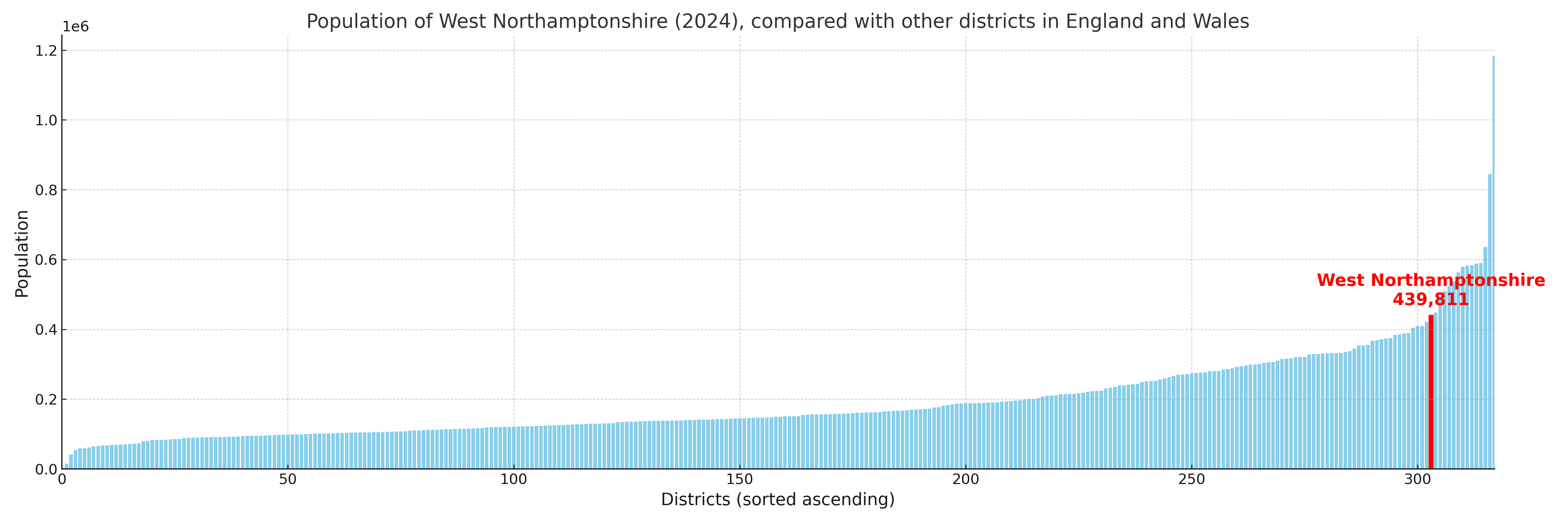
West Northamptonshire compared with other districts in the UK
This section shows how West Northamptonshire compares with other local authority districts in the UK, using a variety of measures and rankings.
West Northamptonshire has 31 electoral wards.

West Northamptonshire has a population of 439,811 (2024 mid-year estimate by ONS)
Population and Migration Trends in West Northamptonshire
This chart shows the population trend for West Northamptonshire from 2015 to 2024. It provides a quick overview of whether the local authority is growing, stable, or declining over time, and helps set context for the migration patterns shown below.
Population change is influenced by natural change (births minus deaths) and migration. The net migration chart below focuses on migration, separating internal migration (moves within the UK) from international migration (moves to and from abroad). Positive values indicate net inflows, while negative values indicate net outflows. The rate labels (per 1,000 residents) help compare migration intensity across years, even when the population size changes.
More local statistics and data for West Northamptonshire can be found on the ONS statistics for West Northamptonshire.
Latest news about West Northamptonshire
Use the search box, or suggested search phrases, below to find recent news, council updates, planning stories, housing developments, transport changes, public services news, local elections, community issues and other local developments related to West Northamptonshire. Results may include coverage from UK national, regional and local news websites, as well as official public-sector and local democracy sources.
- West Northamptonshire council
- West Northamptonshire planning
- West Northamptonshire local elections
- West Northamptonshire housing
- West Northamptonshire transport
- West Northamptonshire regeneration
- West Northamptonshire public services