North Northamptonshire
§ This page gives an overview of the North Northamptonshire local authority district, bringing together key facts, maps, and data to help you quickly understand the area. This is one of 361 LAD profiles on Baseview.
Overview ⁞ North Northamptonshire encompasses a mix of market towns, historic villages, and broad swathes of countryside. Kettering, with its cultural venues and Wicksteed Park, is one of the largest centres, while Corby has woodland surroundings and a history tied to the steel industry. Wellingborough sits along the River Nene, offering riverside walks and parks, and Rushden is noted for its lakes and retail hub. Smaller towns like Oundle and Thrapston retain strong historic character with stone buildings and traditional markets. The landscape is shaped by river valleys, rolling farmland, and country estates, with Stanwick Lakes and Rockingham Forest providing extensive natural habitats and outdoor attractions. Its combination of towns, waterways, and rural scenery makes North Northamptonshire a varied and distinctive area.
North Northamptonshire Boundary Map
This map shows the official boundary of the North Northamptonshire local authority district, based on the latest geographic data published by the Office for National Statistics (ONS). It provides a clear view of the district’s extent and helps you understand how the area fits within the wider regional and national landscape.
Contains OS data © Crown copyright and database right 2025. Source: Office for National Statistics licensed under the Open Government Licence v3.0.
The administrative boundary of North Northamptonshire can also be viewed on OpenStreetMap: District Boundary of North Northamptonshire.
Key Facts about North Northamptonshire
What region is North Northamptonshire in? North Northamptonshire is in the East Midlands of England, a region within the UK.
What county is North Northamptonshire in? North Northamptonshire is in the county of Northamptonshire.
Is North Northamptonshire a city? No, North Northamptonshire is not a city. (Note: the UK has 76 officially designated cities.)
Who governs North Northamptonshire? The local government for this district is: North Northamptonshire Council (Unitary Authority).
▶ Official website of North Northamptonshire Council 🔗 northnorthants.gov.uk
Which police force covers North Northamptonshire? Policing in North Northamptonshire is provided by Northamptonshire Police 🔗 northants.police.uk, which serves 2 local authority districts: North Northamptonshire ⁞ West Northamptonshire.
North Northamptonshire in International Geographies
In the International Territorial Levels (ITLs) hierarchy, North Northamptonshire is an ITLs Level 3 area:
- (ITL 1) East Midlands
- (ITL 2) ⇒ Leicestershire, Rutland and Northamptonshire
- (ITL 3) ⇒⇒ North Northamptonshire
The International Territorial Levels are used by OECD member countries for statistical purposes to classify administrative areas. We have this listable page for easy browsing of ITL names and codes: International Territorial Levels.
Constituencies in North Northamptonshire
North Northamptonshire is divided into 5 parliamentary constituencies, listed below in alphabetical order.
- Corby and East Northamptonshire
- Daventry
- Kettering
- South Northamptonshire
- Wellingborough and Rushden
A constituency is a specific geographical area that elects one Member of Parliament (MP) to represent them in the House of Commons. The United Kingdom is divided into 650 parliamentary constituencies. We have this list page for easy browsing of all UK parliamentary constituencies: List of Constituencies.
Wards in North Northamptonshire
North Northamptonshire is divided into 26 wards, listed below in alphabetical order.
- Brickhill and Queensway
- Burton and Broughton
- Clover Hill
- Corby Rural
- Corby West
- Croyland and Swanspool
- Desborough
- Earls Barton
- Finedon
- Hatton Park
- Higham Ferrers
- Irchester
- Irthlingborough
- Ise
- Kingswood
- Lloyds
- Northall
- Oakley
- Oundle
- Raunds
- Rothwell and Mawsley
- Rushden Pemberton West
- Rushden South
- Thrapston
- Wicksteed
- Windmill
In the UK, a ward is a subdivision of a local authority area, used mainly for electoral and statistical purposes. Defined by the ONS, wards represent the primary unit for local elections, each returning one or more councillors to the local council. Wards are also used as a key geography for presenting population and census data. We have this list page for easy browsing of all electoral wards: List of all Electoral Wards in the UK.
Parishes in North Northamptonshire
North Northamptonshire is fully parished: 113 civil parishes, listed A-Z below.
- Aldwincle
- Apethorpe
- Ashley
- Ashton
- Barnwell
- Barton Seagrave
- Benefield
- Blatherwycke
- Bozeat
- Brampton Ash
- Braybrooke
- Brigstock
- Broughton
- Bulwick
- Burton Latimer
- Chelveston-cum-Caldecott
- Clopton
- Collyweston
- Corby
- Cotterstock
- Cottingham
- Cranford
- Cransley
- Deene
- Deenethorpe
- Denford
- Desborough
- Dingley
- Duddington-with-Fineshade
- Earls Barton
- East Carlton
- Easton Maudit
- Easton on the Hill
- Ecton
- Finedon
- Fotheringhay
- Geddington
- Glapthorn
- Grafton Underwood
- Great Addington
- Great Doddington
- Great Harrowden
- Grendon
- Gretton
- Hardwick
- Hargrave
- Harrington
- Harringworth
- Hemington
- Higham Ferrers
- Irchester
- Irthlingborough
- Isham
- Islip
- Kettering Town
- King's Cliffe
- Laxton
- Lilford-cum-Wigsthorpe
- Little Addington
- Little Harrowden
- Little Stanion
- Loddington
- Lowick
- Luddington
- Lutton
- Mawsley
- Mears Ashby
- Middleton
- Nassington
- Newton and Little Oakley
- Newton Bromswold
- Orlingbury
- Orton
- Oundle
- Pilton
- Polebrook
- Pytchley
- Raunds
- Ringstead
- Rockingham
- Rothwell
- Rushden
- Rushton
- Southwick
- Stanion
- Stanwick
- Stoke Albany
- Stoke Doyle
- Strixton
- Sudborough
- Sutton Bassett
- Sywell
- Tansor
- Thorpe Achurch
- Thorpe Malsor
- Thrapston
- Thurning
- Titchmarsh
- Twywell
- Wadenhoe
- Wakerley
- Warkton
- Warmington
- Weekley
- Weldon
- Wellingborough
- Weston by Welland
- Wilbarston
- Wilby
- Wollaston
- Woodford
- Woodnewton
- Yarwell
A civil parish is the lowest tier of local government in England, used for villages, small towns, and suburbs. They have their own local authority, either a parish council or a parish meeting, which provides local services like managing parks, allotments, and streetlights, and represents the community's views to larger councils.
We have this list page for easy browsing of all parishes: List of Civil Parishes in England and Wales.
Post Towns in North Northamptonshire
Below is a list of post towns in North Northamptonshire, grouped by postcode area:
- NN ▸ Corby (NN17 / NN18) ⁞ Kettering (NN14 / NN15 / NN16) ⁞ Rushden (NN10) ⁞ Wellingborough (NN8 / NN9 / NN29)
The UK postal hierarchy begins with broad postcode areas (such as “CB” or “M”), which are divided into smaller postcode districts (such as “CB8” or “M1”) to support accurate mail routing. Each postal address is anchored by a designated post town, the official locality name used in the UK postcode system, which operates independently from Local Authority Districts —the administrative boundaries used for council tax and local government services. Because they serve different purposes, a property’s postal address and its local authority district do not always align exactly.
Built-up Areas in North Northamptonshire
North Northamptonshire covers 66 built-up areas, listed below in alphabetical order.
- Aldwincle
- Ashley (North Northamptonshire)
- Barnwell
- Barrowden *
- Bozeat
- Braybrooke
- Brigstock
- Broughton (North Northamptonshire)
- Burton Latimer
- Collyweston
- Corby
- Cottingham and Middleton
- Desborough
- Earls Barton
- Easton on the Hill
- Ecton
- Finedon
- Geddington
- Glapthorn
- Great Addington
- Great Doddington
- Grendon (North Northamptonshire) *
- Gretton (North Northamptonshire)
- Hargrave *
- Higham Ferrers
- Irchester
- Irthlingborough
- Isham
- Islip (North Northamptonshire)
- Kettering
- Ketton *
- King's Cliffe
- Little Harrowden
- Little Irchester
- Loddington
- Market Harborough *
- Mawsley Village *
- Mears Ashby
- Nassington
- Northampton *
- Orlingbury
- Oundle
- Polebrook
- Pytchley
- Raunds
- Ringstead (North Northamptonshire)
- Rothwell (North Northamptonshire)
- Rushden *
- Rushton
- Stanion
- Stanwick
- Sywell and Overstone *
- Thrapston
- Titchmarsh
- Wansford *
- Warmington (North Northamptonshire)
- Weldon
- Wellingborough
- Wilbarston
- Wilby
- Wittering *
- Wollaston
- Woodford (North Northamptonshire)
- Woodnewton
- Wymington *
- Yarwell
In the UK, a Built-up Area (BUA) is a continuous urban area of at least 20 hectares (0.2 km²), defined by the ONS as land where buildings are generally no more than 200 metres apart, such as towns, cities, or large villages. (Note: A BUA name marked with an asterisk (*) indicates that the area is situated partly in the district of North Northamptonshire.)
We have this list page for easy browsing of all built-up areas: List of all Built-up Areas in GB.
Railway Stations in North Northamptonshire
North Northamptonshire is served by a number of National Rail stations, providing rail connections to nearby towns, cities, and destinations across Great Britain. The railway stations listed below are located within the North Northamptonshire Local Authority District and are grouped by train operating company for clarity.
- East Midlands Railway ▸ Kettering (NN15 7HJ) ⁞ Wellingborough (NN8 1NA) ⁞ Corby (NN17 1UJ)
This is a district-level view only. For a complete list of all National Rail stations across Great Britain, see the UK National Rail Stations Directory.
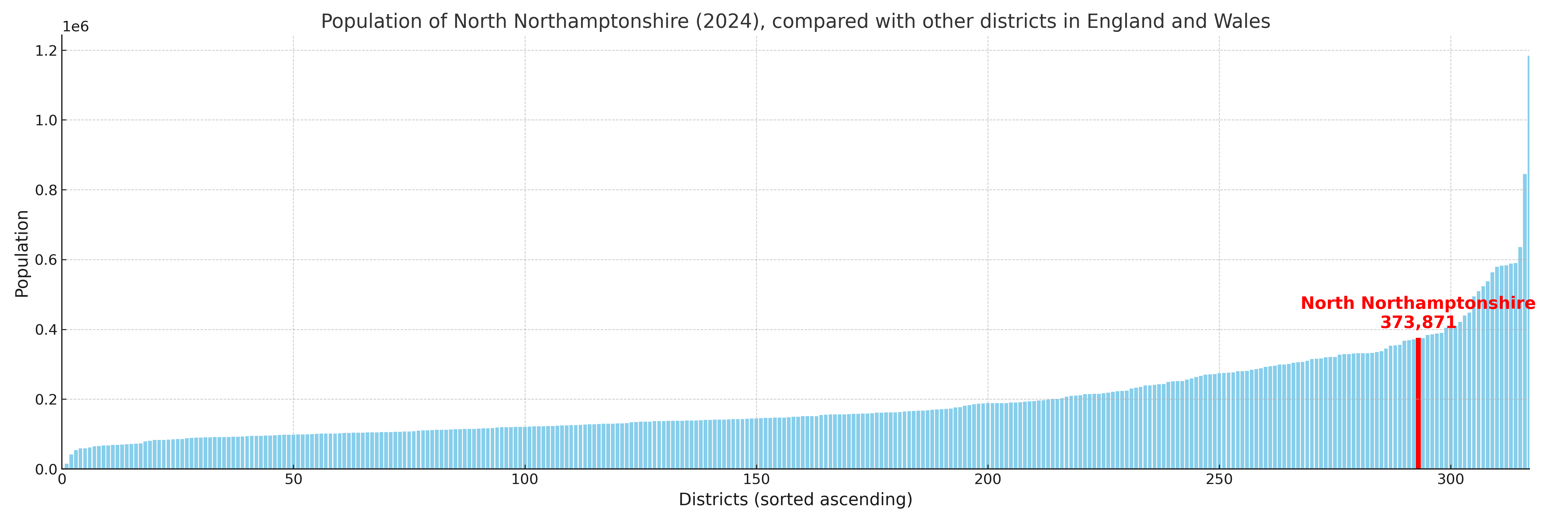
North Northamptonshire compared with other districts in the UK
This section shows how North Northamptonshire compares with other local authority districts in the UK, using a variety of measures and rankings.
North Northamptonshire has 26 electoral wards.

North Northamptonshire has a population of 373,871 (2024 mid-year estimate by ONS)
Population and Migration Trends in North Northamptonshire
This chart shows the population trend for North Northamptonshire from 2015 to 2024. It provides a quick overview of whether the local authority is growing, stable, or declining over time, and helps set context for the migration patterns shown below.
Population change is influenced by natural change (births minus deaths) and migration. The net migration chart below focuses on migration, separating internal migration (moves within the UK) from international migration (moves to and from abroad). Positive values indicate net inflows, while negative values indicate net outflows. The rate labels (per 1,000 residents) help compare migration intensity across years, even when the population size changes.
More local statistics and data for North Northamptonshire can be found on the ONS statistics for North Northamptonshire.
Latest news about North Northamptonshire
Use the search box, or suggested search phrases, below to find recent news, council updates, planning stories, housing developments, transport changes, public services news, local elections, community issues and other local developments related to North Northamptonshire. Results may include coverage from UK national, regional and local news websites, as well as official public-sector and local democracy sources.
- North Northamptonshire council
- North Northamptonshire planning
- North Northamptonshire local elections
- North Northamptonshire housing
- North Northamptonshire transport
- North Northamptonshire regeneration
- North Northamptonshire public services