North Kesteven
§ This page gives an overview of the North Kesteven local authority district, bringing together key facts, maps, and data to help you quickly understand the area. This is one of 361 LAD profiles on Baseview.
Overview ⁞ North Kesteven covers a wide area of rural Lincolnshire south of Lincoln, characterised by open farmland, small villages, and historic market towns. Sleaford serves as its main town, with the River Slea and Cogglesford Mill adding charm. The district includes RAF heritage sites, airfields, and aviation museums reflecting Lincolnshire’s military history. Villages are marked by ancient churches, traditional pubs, and community events, while the flat fenland and wide skies dominate the landscape. North Kesteven balances rural tranquillity with cultural and historic attractions.
North Kesteven Boundary Map
This map shows the official boundary of the North Kesteven local authority district, based on the latest geographic data published by the Office for National Statistics (ONS). It provides a clear view of the district’s extent and helps you understand how the area fits within the wider regional and national landscape.
Contains OS data © Crown copyright and database right 2025. Source: Office for National Statistics licensed under the Open Government Licence v3.0.
The administrative boundary of North Kesteven can also be viewed on OpenStreetMap: District Boundary of North Kesteven.
Key Facts about North Kesteven
What region is North Kesteven in? North Kesteven is in the East Midlands of England, a region within the UK.
What county is North Kesteven in? North Kesteven is located in the county of Lincolnshire.
Is North Kesteven a city? No, North Kesteven is not a city. (Note: the UK has 76 officially designated cities.)
Who governs North Kesteven? The local authority for this district is: North Kesteven District Council - responsible for district-level services. Since Lincolnshire is a two-tier area, county-level services are handled by: Lincolnshire County Council.
▶ Official website of North Kesteven District Council 🔗 n-kesteven.gov.uk
Which police force covers North Kesteven? Policing in North Kesteven is provided by Lincolnshire Police 🔗 lincs.police.uk, which serves 7 local authority districts: Boston ⁞ East Lindsey ⁞ Lincoln ⁞ North Kesteven ⁞ South Holland ⁞ South Kesteven ⁞ West Lindsey.
Constituencies in North Kesteven
North Kesteven is divided into 3 parliamentary constituencies, listed below in alphabetical order.
A constituency is a specific geographical area that elects one Member of Parliament (MP) to represent them in the House of Commons. The United Kingdom is divided into 650 parliamentary constituencies. We have this list page for easy browsing of all UK parliamentary constituencies: List of Constituencies.
Wards in North Kesteven
North Kesteven is divided into 24 wards, listed below in alphabetical order.
- Ashby de la Launde, Digby & Scopwick
- Bassingham Rural
- Billinghay Rural
- Bracebridge Heath
- Branston
- Cranwell, Leasingham & Wilsford
- Heckington Rural
- Heighington & Washingborough
- Helpringham & Osbournby
- Hykeham Central
- Hykeham Fosse
- Hykeham Memorial
- Kirkby la Thorpe & South Kyme
- Metheringham Rural
- Navenby & Brant Broughton
- Ruskington
- Skellingthorpe & Eagle
- Sleaford Castle
- Sleaford Holdingham
- Sleaford Navigation
- Sleaford Quarrington & Mareham
- Sleaford Westholme
- Waddington Rural
- Witham St Hughs & Swinderby
In the UK, a ward is a subdivision of a local authority area, used mainly for electoral and statistical purposes. Defined by the ONS, wards represent the primary unit for local elections, each returning one or more councillors to the local council. Wards are also used as a key geography for presenting population and census data. We have this list page for easy browsing of all electoral wards: List of all Electoral Wards in the UK.
Parishes in North Kesteven
North Kesteven is part-parished: 75 civil parishes (listed A-Z below) alongside 1 unparished areas.
- Anwick
- Asgarby and Howell
- Ashby de la Launde and Bloxholm
- Aswarby and Swarby
- Aubourn with Haddington
- Aunsby and Dembleby
- Bassingham
- Beckingham
- Billinghay
- Blankney
- Boothby Graffoe
- Bracebridge Heath
- Branston and Mere
- Brant Broughton and Stragglethorpe
- Burton Pedwardine
- Canwick
- Carlton-le-Moorland
- Coleby
- Cranwell, Brauncewell and Byard's Leap
- Culverthorpe and Kelby
- Digby
- Doddington and Whisby
- Dogdyke
- Dorrington
- Dunston
- Eagle and Swinethorpe
- Ewerby and Evedon
- Great Hale
- Harmston
- Heckington
- Heighington
- Helpringham
- Kirkby la Thorpe
- Leadenham
- Leasingham
- Little Hale
- Martin
- Metheringham
- Navenby
- Newton and Haceby
- Nocton
- North Hykeham
- North Kyme
- North Rauceby
- North Scarle
- Norton Disney
- Osbournby
- Potter Hanworth
- Rowston
- Roxholm
- Ruskington
- Scopwick
- Scredington
- Silk Willoughby
- Skellingthorpe
- Sleaford
- South Hykeham
- South Kyme
- South Rauceby
- Stapleford
- Swaton
- Swinderby
- Temple Bruer with Temple High Grange
- Thorpe on the Hill
- Threekingham
- Thurlby
- Timberland
- Waddington
- Walcot near Folkingham
- Walcott
- Washingborough
- Welbourn
- Wellingore
- Wilsford
- Witham St. Hughs
A civil parish is the lowest tier of local government in England, used for villages, small towns, and suburbs. They have their own local authority, either a parish council or a parish meeting, which provides local services like managing parks, allotments, and streetlights, and represents the community's views to larger councils.
We have this list page for easy browsing of all parishes: List of Civil Parishes in England and Wales.
Post Towns in North Kesteven
Below is a list of post towns in North Kesteven, grouped by postcode area:
NG ▸ Sleaford (NG34)
The UK postal hierarchy begins with broad postcode areas (such as “CB” or “M”), which are divided into smaller postcode districts (such as “CB8” or “M1”) to support accurate mail routing. Each postal address is anchored by a designated post town, the official locality name used in the UK postcode system, which operates independently from Local Authority Districts —the administrative boundaries used for council tax and local government services. Because they serve different purposes, a property’s postal address and its local authority district do not always align exactly.
Built-up Areas in North Kesteven
North Kesteven covers 57 built-up areas, listed below in alphabetical order.
- Ancaster *
- Anwick
- Ashby de la Launde
- Bardney *
- Bassingham
- Billinghay
- Bracebridge Heath
- Branston
- Brant Broughton
- Brauncewell
- Burton Waters *
- Byard's Leap
- Canwick *
- Carlton-le-Moorland
- Coleby
- Cranwell
- Digby
- Dorrington (North Kesteven)
- Dunston
- Eagle
- Ewerby
- Great Hale
- Greylees
- Harmston
- Heckington
- Helpringham
- Leadenham
- Leasingham
- Lincoln *
- Martin (North Kesteven)
- Metheringham
- Morton Hall
- Navenby
- Nocton
- North Hykeham *
- North Kyme
- North Scarle
- Osbournby
- Potterhanworth
- Ruskington
- Scopwick
- Silk Willoughby
- Skellingthorpe
- Sleaford
- South Hykeham
- South Kyme
- Swinderby
- Thorpe on the Hill (North Kesteven)
- Timberland
- Waddington (North Kesteven) *
- Walcott (North Kesteven)
- Washingborough and Heighington
- Welbourn
- West Willoughby *
- Wilsford
- Witham St Hughs
- Woodhall Spa *
In the UK, a Built-up Area (BUA) is a continuous urban area of at least 20 hectares (0.2 km²), defined by the ONS as land where buildings are generally no more than 200 metres apart, such as towns, cities, or large villages. (Note: A BUA name marked with an asterisk (*) indicates that the area is situated partly in the district of North Kesteven.)
We have this list page for easy browsing of all built-up areas: List of all Built-up Areas in GB.
Railway Stations in North Kesteven
North Kesteven is served by a number of National Rail stations, providing rail connections to nearby towns, cities, and destinations across Great Britain. The railway stations listed below are located within the North Kesteven Local Authority District and are grouped by train operating company for clarity.
- East Midlands Railway ▸ Sleaford (NG34 7RG) ⁞ Hykeham (LN6 9AT) ⁞ Metheringham (LN4 3HX) ⁞ Ruskington (NG34 9ED) ⁞ Heckington (NG34 9UJ) ⁞ Swinderby (LN6 9HY) ⁞ Rauceby (NG34 8PP)
This is a district-level view only. For a complete list of all National Rail stations across Great Britain, see the UK National Rail Stations Directory.
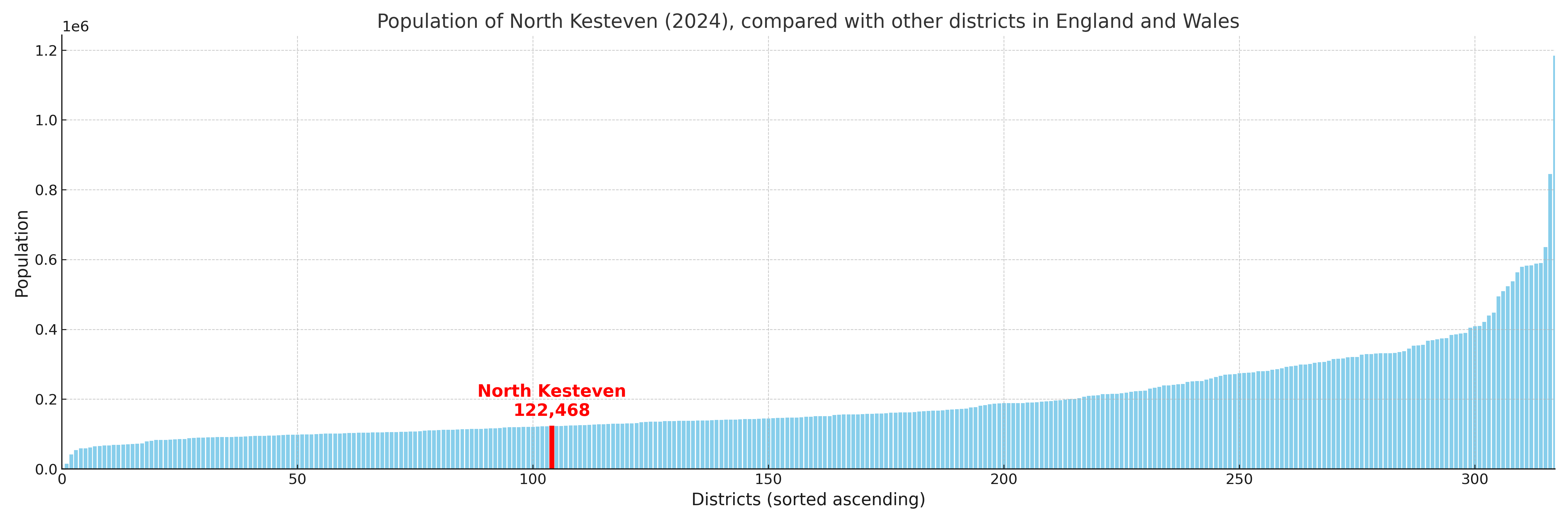
North Kesteven compared with other districts in the UK
This section shows how North Kesteven compares with other local authority districts in the UK, using a variety of measures and rankings.
North Kesteven has 24 electoral wards.

North Kesteven has a population of 122,468 (2024 mid-year estimate by ONS)
Population and Migration Trends in North Kesteven
This chart shows the population trend for North Kesteven from 2015 to 2024. It provides a quick overview of whether the local authority is growing, stable, or declining over time, and helps set context for the migration patterns shown below.
Population change is influenced by natural change (births minus deaths) and migration. The net migration chart below focuses on migration, separating internal migration (moves within the UK) from international migration (moves to and from abroad). Positive values indicate net inflows, while negative values indicate net outflows. The rate labels (per 1,000 residents) help compare migration intensity across years, even when the population size changes.
More local statistics and data for North Kesteven can be found on the ONS statistics for North Kesteven.
Latest news about North Kesteven
Use the search box, or suggested search phrases, below to find recent news, council updates, planning stories, housing developments, transport changes, public services news, local elections, community issues and other local developments related to North Kesteven. Results may include coverage from UK national, regional and local news websites, as well as official public-sector and local democracy sources.
- North Kesteven council
- North Kesteven planning
- North Kesteven local elections
- North Kesteven housing
- North Kesteven transport
- North Kesteven regeneration
- North Kesteven public services