East Lindsey
§ This page gives an overview of the East Lindsey local authority district, bringing together key facts, maps, and data to help you quickly understand the area. This is one of 361 LAD profiles on Baseview.
Overview ⁞ East Lindsey is one of the largest districts in Lincolnshire, stretching from the Lincolnshire Wolds to the North Sea coast. Market towns such as Louth, Horncastle, and Alford sit among rolling hills and farmland, with Louth known as the “capital of the Wolds.” The coastline includes popular resorts like Skegness, Mablethorpe, and Sutton-on-Sea, famed for sandy beaches and family holidays. Inland, the Wolds Area of Outstanding Natural Beauty offers scenic walking and cycling routes. The district blends coastal tourism with rural charm, creating a diverse and expansive landscape.
East Lindsey Boundary Map
This map shows the official boundary of the East Lindsey local authority district, based on the latest geographic data published by the Office for National Statistics (ONS). It provides a clear view of the district’s extent and helps you understand how the area fits within the wider regional and national landscape.
Contains OS data © Crown copyright and database right 2025. Source: Office for National Statistics licensed under the Open Government Licence v3.0.
The administrative boundary of East Lindsey can also be viewed on OpenStreetMap: District Boundary of East Lindsey.
Key Facts about East Lindsey
What region is East Lindsey in? East Lindsey is in the East Midlands of England, a region within the UK.
What county is East Lindsey in? East Lindsey is located in the county of Lincolnshire.
Is East Lindsey a city? No, East Lindsey is not a city. (Note: the UK has 76 officially designated cities.)
Who governs East Lindsey? The local authority for this district is: East Lindsey District Council - responsible for district-level services. Since Lincolnshire is a two-tier area, county-level services are handled by: Lincolnshire County Council.
▶ Official website of East Lindsey District Council 🔗 e-lindsey.gov.uk

Which police force covers East Lindsey? Policing in East Lindsey is provided by Lincolnshire Police 🔗 lincs.police.uk, which serves 7 local authority districts: Boston ⁞ East Lindsey ⁞ Lincoln ⁞ North Kesteven ⁞ South Holland ⁞ South Kesteven ⁞ West Lindsey.
Constituencies in East Lindsey
East Lindsey is divided into 2 parliamentary constituencies, listed below in alphabetical order.
A constituency is a specific geographical area that elects one Member of Parliament (MP) to represent them in the House of Commons. The United Kingdom is divided into 650 parliamentary constituencies. We have this list page for easy browsing of all UK parliamentary constituencies: List of Constituencies.
Wards in East Lindsey
East Lindsey is divided into 37 wards, listed below in alphabetical order.
- Alford
- Binbrook
- Burgh le Marsh
- Chapel St Leonards
- Coningsby & Mareham
- Croft
- Friskney
- Fulstow
- Grimoldby
- Hagworthingham
- Halton Holegate
- Holton-le-Clay & North Thoresby
- Horncastle
- Ingoldmells
- Legbourne
- Mablethorpe
- Marshchapel & Somercotes
- North Holme
- Priory & St James'
- Roughton
- Scarbrough & Seacroft
- Sibsey & Stickney
- Spilsby
- St Clement's
- St Margaret's
- St Mary's
- St Michael's
- Sutton on Sea
- Tetford & Donington
- Tetney
- Trinity
- Wainfleet
- Willoughby with Sloothby
- Winthorpe
- Withern & Theddlethorpe
- Woodhall Spa
- Wragby
In the UK, a ward is a subdivision of a local authority area, used mainly for electoral and statistical purposes. Defined by the ONS, wards represent the primary unit for local elections, each returning one or more councillors to the local council. Wards are also used as a key geography for presenting population and census data. We have this list page for easy browsing of all electoral wards: List of all Electoral Wards in the UK.
Parishes in East Lindsey
East Lindsey is fully parished: 188 civil parishes, listed A-Z below.
- Aby with Greenfield
- Addlethorpe
- Alford
- Alvingham
- Anderby
- Ashby with Scremby
- Asterby
- Aswardby
- Authorpe
- Baumber
- Beesby with Saleby
- Belchford
- Belleau
- Benniworth
- Bilsby
- Binbrook
- Bolingbroke
- Brackenborough with Little Grimsby
- Bratoft
- Brinkhill
- Bucknall
- Burgh le Marsh
- Burgh on Bain
- Burwell
- Calcethorpe with Kelstern
- Candlesby with Gunby
- Carrington and New Bolingbroke
- Chapel St. Leonards
- Claxby St Andrew
- Claxby with Moorby
- Claythorpe
- Coningsby
- Conisholme
- Covenham St Bartholomew
- Covenham St Mary
- Croft
- Cumberworth
- Dalby
- Donington on Bain
- East Barkwith
- East Keal
- East Kirkby
- Eastville
- Edlington with Wispington
- Elkington
- Farlesthorpe
- Firsby
- Fotherby
- Friskney
- Frithville and Westville
- Fulletby
- Fulstow
- Gautby
- Gayton le Marsh
- Gayton le Wold
- Goulceby
- Grainsby
- Grainthorpe
- Great Carlton
- Great Steeping
- Great Sturton
- Greetham with Somersby
- Grimoldby
- Hagworthingham
- Hainton
- Hallington
- Haltham
- Halton Holegate
- Hameringham
- Hannah cum Hagnaby
- Harrington
- Hatton
- Haugh
- Haugham
- Hemingby
- High Toynton
- Hogsthorpe
- Holton le Clay
- Horncastle
- Horsington
- Hundleby
- Huttoft
- Ingoldmells
- Irby in the Marsh
- Keddington
- Kirkby on Bain
- Langriville
- Langton
- Langton by Spilsby
- Langton by Wragby
- Legbourne
- Little Carlton
- Little Cawthorpe
- Little Steeping
- Louth
- Low Toynton
- Ludborough
- Ludford
- Lusby with Winceby
- Mablethorpe and Sutton
- Maidenwell
- Maltby le Marsh
- Manby
- Mareham le Fen
- Mareham on the Hill
- Markby
- Market Stainton
- Marshchapel
- Mavis Enderby
- Midville
- Minting
- Muckton
- Mumby
- New Leake
- North Cockerington
- North Cotes
- North Ormsby
- North Somercotes
- North Thoresby
- Orby
- Partney
- Raithby
- Raithby cum Maltby
- Ranby
- Reston
- Revesby
- Rigsby with Ailby
- Roughton
- Saltfleetby
- Sausthorpe
- Scamblesby
- Scrivelsby
- Sibsey
- Skegness
- Skendleby
- Skidbrooke with Saltfleet Haven
- Sotby
- South Cockerington
- South Ormsby cum Ketsby
- South Somercotes
- South Thoresby
- South Willingham
- Spilsby
- Stenigot
- Stewton
- Stickford
- Stickney
- Stixwould and Woodhall
- Strubby with Woodthorpe
- Swaby
- Tathwell
- Tattershall
- Tattershall Thorpe
- Tetford
- Tetney
- Theddlethorpe All Saints
- Theddlethorpe St Helen
- Thimbleby
- Thornton le Fen
- Thorpe St. Peter
- Toynton All Saints
- Toynton St Peter
- Tumby
- Tupholme
- Ulceby with Fordington
- Utterby
- Waddingworth
- Wainfleet All Saints
- Wainfleet St Mary
- Waithe
- Walmsgate
- Well
- Welton le Marsh
- Welton le Wold
- West Ashby
- West Barkwith
- West Fen
- West Keal
- West Torrington
- Wildmore
- Willoughby with Sloothby
- Withcall
- Withern with Stain
- Wood Enderby
- Woodhall Spa
- Wragby
- Wyham cum Cadeby
- Yarburgh
A civil parish is the lowest tier of local government in England, used for villages, small towns, and suburbs. They have their own local authority, either a parish council or a parish meeting, which provides local services like managing parks, allotments, and streetlights, and represents the community's views to larger councils.
We have this list page for easy browsing of all parishes: List of Civil Parishes in England and Wales.
Post Towns in East Lindsey
Below is a list of post towns in East Lindsey, grouped by postcode area:
- LN ▸ Alford (LN13) ⁞ Horncastle (LN9) ⁞ Louth (LN11) ⁞ Mablethorpe (LN12) ⁞ Woodhall Spa (LN10)
- PE ▸ Skegness (PE24 / PE25) ⁞ Spilsby (PE23)
The UK postal hierarchy begins with broad postcode areas (such as “CB” or “M”), which are divided into smaller postcode districts (such as “CB8” or “M1”) to support accurate mail routing. Each postal address is anchored by a designated post town, the official locality name used in the UK postcode system, which operates independently from Local Authority Districts —the administrative boundaries used for council tax and local government services. Because they serve different purposes, a property’s postal address and its local authority district do not always align exactly.
Built-up Areas in East Lindsey
East Lindsey covers 62 built-up areas, listed below in alphabetical order.
- Alford (East Lindsey)
- Alvingham
- Anderby Creek
- Bardney *
- Belchford
- Bilsby
- Binbrook
- Burgh le Marsh
- Chapel St Leonards
- Coningsby and Tattershall
- Covenham St Mary
- East Barkwith
- East Keal
- Friskney
- Friskney Eaudyke
- Fulstow
- Goulceby
- Grainthorpe
- Hagnaby
- Hagworthingham
- Halton Holegate
- Hogsthorpe
- Holton le Clay *
- Horncastle
- Humberston and New Waltham *
- Huttoft
- Ingoldmells
- Kirkby on Bain
- Legbourne
- Louth
- Ludborough
- Ludford
- Mablethorpe
- Maltby le Marsh
- Manby
- Mareham le Fen
- Marshchapel
- Mumby
- North Somercotes
- North Thoresby
- Old Bolingbroke
- Saltfleet
- Saltfleetby St Peter
- Scamblesby
- Sibsey
- Skegness
- Spilsby
- Stickford
- Stickney
- Sutton on Sea and Trusthorpe
- Tattershall
- Tetford
- Tetney
- Toynton All Saints
- Utterby
- Wainfleet All Saints
- Wainfleet St Mary
- West Keal
- Willoughby (East Lindsey)
- Withern
- Woodhall Spa *
- Wragby
In the UK, a Built-up Area (BUA) is a continuous urban area of at least 20 hectares (0.2 km²), defined by the ONS as land where buildings are generally no more than 200 metres apart, such as towns, cities, or large villages. (Note: A BUA name marked with an asterisk (*) indicates that the area is situated partly in the district of East Lindsey.)
We have this list page for easy browsing of all built-up areas: List of all Built-up Areas in GB.
Railway Stations in East Lindsey
East Lindsey is served by a number of National Rail stations, providing rail connections to nearby towns, cities, and destinations across Great Britain. The railway stations listed below are located within the East Lindsey Local Authority District and are grouped by train operating company for clarity.
- East Midlands Railway ▸ Skegness (PE25 3QL) ⁞ Wainfleet (PE24 2DR) ⁞ Havenhouse (PE24 4AR) ⁞ Thorpe Culvert (PE24 4NL)
This is a district-level view only. For a complete list of all National Rail stations across Great Britain, see the UK National Rail Stations Directory.
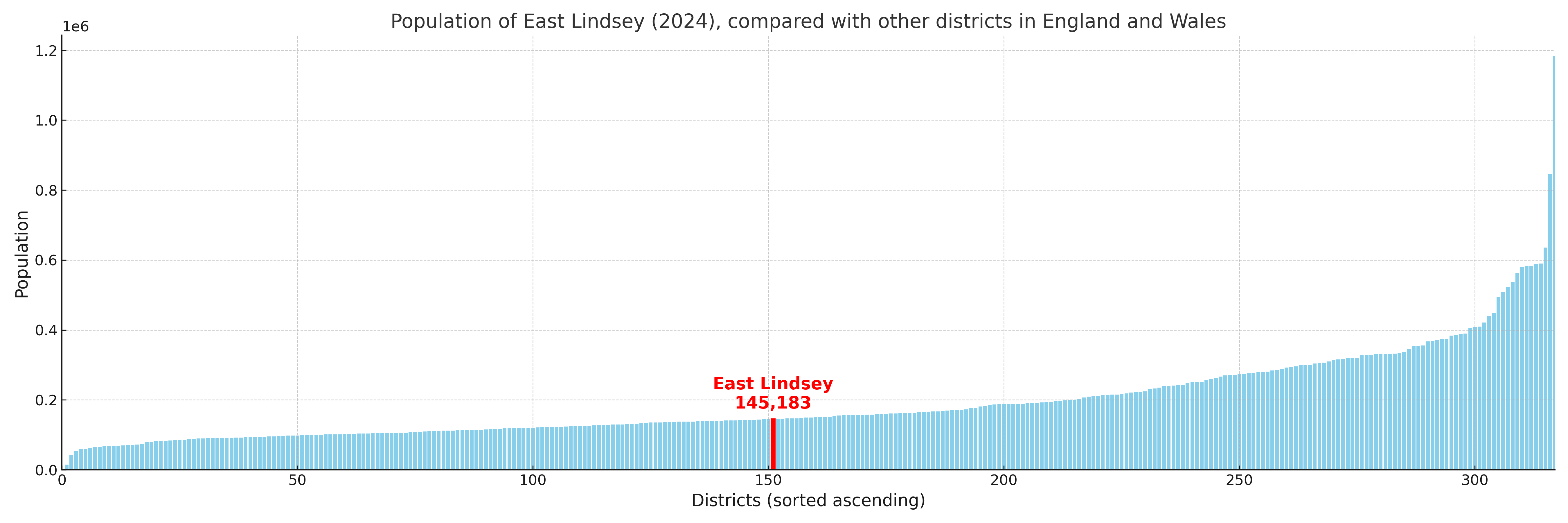
East Lindsey compared with other districts in the UK
This section shows how East Lindsey compares with other local authority districts in the UK, using a variety of measures and rankings.
East Lindsey has 37 electoral wards.

East Lindsey has a population of 145,183 (2024 mid-year estimate by ONS)
Population and Migration Trends in East Lindsey
This chart shows the population trend for East Lindsey from 2015 to 2024. It provides a quick overview of whether the local authority is growing, stable, or declining over time, and helps set context for the migration patterns shown below.
Population change is influenced by natural change (births minus deaths) and migration. The net migration chart below focuses on migration, separating internal migration (moves within the UK) from international migration (moves to and from abroad). Positive values indicate net inflows, while negative values indicate net outflows. The rate labels (per 1,000 residents) help compare migration intensity across years, even when the population size changes.
More local statistics and data for East Lindsey can be found on the ONS statistics for East Lindsey.
Latest news about East Lindsey
Use the search box, or suggested search phrases, below to find recent news, council updates, planning stories, housing developments, transport changes, public services news, local elections, community issues and other local developments related to East Lindsey. Results may include coverage from UK national, regional and local news websites, as well as official public-sector and local democracy sources.
- East Lindsey council
- East Lindsey planning
- East Lindsey local elections
- East Lindsey housing
- East Lindsey transport
- East Lindsey regeneration
- East Lindsey public services