Harborough
§ This page gives an overview of the Harborough local authority district, bringing together key facts, maps, and data to help you quickly understand the area. This is one of 361 LAD profiles on Baseview.
Overview ⁞ Harborough district stretches across south Leicestershire, with the market town of Market Harborough at its heart, known for its historic timber-framed buildings and thriving town centre. The district also includes Lutterworth, famous for links to the inventor of the jet engine, and rural villages set among rolling farmland. The Grand Union Canal weaves through the countryside, with Foxton Locks a key landmark attracting visitors. Its landscapes feature gentle hills, reservoirs, and woodlands, making it a district rich in both heritage and scenic rural charm.
Harborough Boundary Map
This map shows the official boundary of the Harborough local authority district, based on the latest geographic data published by the Office for National Statistics (ONS). It provides a clear view of the district’s extent and helps you understand how the area fits within the wider regional and national landscape.
Contains OS data © Crown copyright and database right 2025. Source: Office for National Statistics licensed under the Open Government Licence v3.0.
The administrative boundary of Harborough can also be viewed on OpenStreetMap: District Boundary of Harborough.
Key Facts about Harborough
What region is Harborough in? Harborough is in the East Midlands of England, a region within the UK.
What county is Harborough in? Harborough is located in the county of Leicestershire.
Is Harborough a city? No, Harborough is not a city. (Note: the UK has 76 officially designated cities.)
Who governs Harborough? The local authority for this district is: Harborough District Council - responsible for district-level services. Since Leicestershire is a two-tier area, county-level services are handled by: Leicestershire County Council.
▶ Official website of Harborough District Council 🔗 harborough.gov.uk
Which police force covers Harborough? Policing in Harborough is provided by Leicestershire Police 🔗 leics.police.uk, which serves 9 local authority districts: Blaby ⁞ Charnwood ⁞ Harborough ⁞ Hinckley and Bosworth ⁞ Leicester ⁞ Melton ⁞ North West Leicestershire ⁞ Oadby and Wigston ⁞ Rutland.
Constituencies in Harborough
Harborough is divided into 3 parliamentary constituencies, listed below in alphabetical order.
A constituency is a specific geographical area that elects one Member of Parliament (MP) to represent them in the House of Commons. The United Kingdom is divided into 650 parliamentary constituencies. We have this list page for easy browsing of all UK parliamentary constituencies: List of Constituencies.
Wards in Harborough
Harborough is divided into 19 wards, listed below in alphabetical order.
- Billesdon & Tilton
- Bosworth
- Broughton Astley South & Leire
- Broughton Astley-Primethorpe & Sutton
- Dunton
- Fleckney
- Glen
- Kibworths
- Lubenham
- Lutterworth East
- Lutterworth West
- Market Harborough-Great Bowden & Arden
- Market Harborough-Little Bowden
- Market Harborough-Logan
- Market Harborough-Welland
- Misterton
- Nevill
- Thurnby & Houghton
- Ullesthorpe
In the UK, a ward is a subdivision of a local authority area, used mainly for electoral and statistical purposes. Defined by the ONS, wards represent the primary unit for local elections, each returning one or more councillors to the local council. Wards are also used as a key geography for presenting population and census data. We have this list page for easy browsing of all electoral wards: List of all Electoral Wards in the UK.
Parishes in Harborough
Harborough is part-parished: 91 civil parishes (listed A-Z below) alongside 3 unparished areas.
- Allexton
- Arnesby
- Ashby Magna
- Ashby Parva
- Billesdon
- Bitteswell with Bittesby
- Blaston
- Bringhurst
- Broughton Astley
- Bruntingthorpe
- Burton Overy
- Carlton Curlieu
- Catthorpe
- Claybrooke Magna
- Claybrooke Parva
- Cold Newton
- Cotesbach
- Cranoe
- Drayton
- Dunton Bassett
- East Langton
- East Norton
- Fleckney
- Foxton
- Frisby
- Frolesworth
- Gaulby
- Gilmorton
- Glooston
- Goadby
- Great Bowden
- Great Easton
- Great Glen
- Gumley
- Hallaton
- Horninghold
- Houghton on the Hill
- Hungarton
- Husbands Bosworth
- Illston on the Hill
- Keyham
- Kibworth Beauchamp
- Kibworth Harcourt
- Kimcote and Walton
- King's Norton
- Knaptoft
- Laughton
- Launde
- Leire
- Little Stretton
- Loddington
- Lowesby
- Lubenham
- Lutterworth
- Marefield
- Medbourne
- Misterton with Walcote
- Mowsley
- Nevill Holt
- North Kilworth
- Noseley
- Owston and Newbold
- Peatling Magna
- Peatling Parva
- Rolleston
- Saddington
- Scraptoft
- Shangton
- Shawell
- Shearsby
- Skeffington
- Slawston
- Smeeton Westerby
- South Kilworth
- Stockerston
- Stonton Wyville
- Stoughton
- Swinford
- Theddingworth
- Thorpe Langton
- Thurnby and Bushby
- Tilton on the Hill and Halstead
- Tugby and Keythorpe
- Tur Langton
- Ullesthorpe
- Welham
- West Langton
- Westrill and Starmore
- Willoughby Waterleys
- Wistow
- Withcote
A civil parish is the lowest tier of local government in England, used for villages, small towns, and suburbs. They have their own local authority, either a parish council or a parish meeting, which provides local services like managing parks, allotments, and streetlights, and represents the community's views to larger councils.
We have this list page for easy browsing of all parishes: List of Civil Parishes in England and Wales.
Post Towns in Harborough
Below is a list of post towns in Harborough, grouped by postcode area:
- LE ▸ Lutterworth (LE17) ⁞ Market Harborough (LE16)
The UK postal hierarchy begins with broad postcode areas (such as “CB” or “M”), which are divided into smaller postcode districts (such as “CB8” or “M1”) to support accurate mail routing. Each postal address is anchored by a designated post town, the official locality name used in the UK postcode system, which operates independently from Local Authority Districts —the administrative boundaries used for council tax and local government services. Because they serve different purposes, a property’s postal address and its local authority district do not always align exactly.
Built-up Areas in Harborough
Harborough covers 34 built-up areas, listed below in alphabetical order.
- Belton-in-Rutland *
- Billesdon
- Bitteswell
- Broughton Astley
- Burton Overy
- Claybrooke Magna
- Dunton Bassett
- Fleckney
- Foxton (Harborough)
- Gartree
- Gilmorton
- Great Bowden
- Great Easton (Harborough)
- Great Glen
- Great Stretton
- Hallaton
- Houghton on the Hill
- Husbands Bosworth
- Kibworth Beauchamp and Kibworth Harcourt
- Leicester *
- Leire
- Lubenham *
- Lutterworth *
- Market Harborough *
- Medbourne
- North Kilworth
- Oadby *
- South Kilworth
- Swinford
- Tilton on the Hill
- Tugby
- Ullesthorpe
- Upper Bruntingthorpe
- Welford (West Northamptonshire) *
In the UK, a Built-up Area (BUA) is a continuous urban area of at least 20 hectares (0.2 km²), defined by the ONS as land where buildings are generally no more than 200 metres apart, such as towns, cities, or large villages. (Note: A BUA name marked with an asterisk (*) indicates that the area is situated partly in the district of Harborough.)
We have this list page for easy browsing of all built-up areas: List of all Built-up Areas in GB.
Railway Stations in Harborough
Harborough is served by a number of National Rail stations, providing rail connections to nearby towns, cities, and destinations across Great Britain. The railway stations listed below are located within the Harborough Local Authority District and are grouped by train operating company for clarity.
East Midlands Railway ▸ Market Harborough (LE16 7DT)
This is a district-level view only. For a complete list of all National Rail stations across Great Britain, see the UK National Rail Stations Directory.
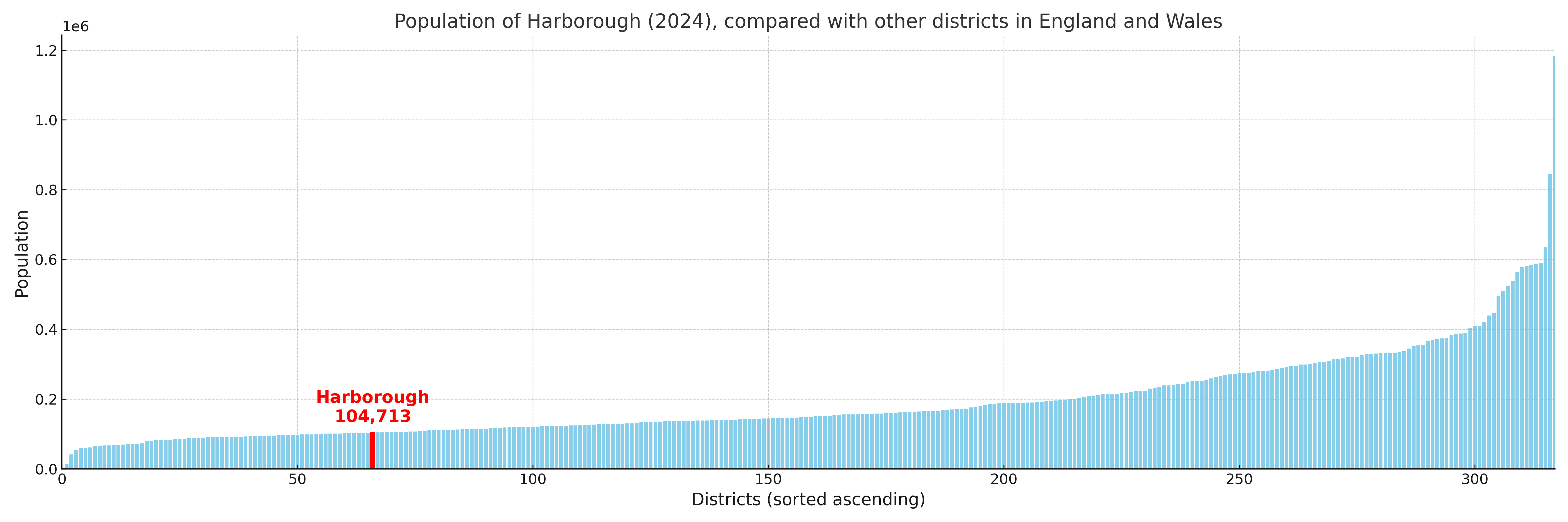
Harborough compared with other districts in the UK
This section shows how Harborough compares with other local authority districts in the UK, using a variety of measures and rankings.
Harborough has 19 electoral wards.

Harborough has a population of 104,713 (2024 mid-year estimate by ONS)
Population and Migration Trends in Harborough
This chart shows the population trend for Harborough from 2015 to 2024. It provides a quick overview of whether the local authority is growing, stable, or declining over time, and helps set context for the migration patterns shown below.
Population change is influenced by natural change (births minus deaths) and migration. The net migration chart below focuses on migration, separating internal migration (moves within the UK) from international migration (moves to and from abroad). Positive values indicate net inflows, while negative values indicate net outflows. The rate labels (per 1,000 residents) help compare migration intensity across years, even when the population size changes.
More local statistics and data for Harborough can be found on the ONS statistics for Harborough.
Latest news about Harborough
Use the search box, or suggested search phrases, below to find recent news, council updates, planning stories, housing developments, transport changes, public services news, local elections, community issues and other local developments related to Harborough. Results may include coverage from UK national, regional and local news websites, as well as official public-sector and local democracy sources.
- Harborough council
- Harborough planning
- Harborough local elections
- Harborough housing
- Harborough transport
- Harborough regeneration
- Harborough public services