Derbyshire Dales
§ This page gives an overview of the Derbyshire Dales local authority district, bringing together key facts, maps, and data to help you quickly understand the area. This is one of 361 LAD profiles on Baseview.
Overview ⁞ Derbyshire Dales is a district of sweeping hills, limestone valleys, and charming market towns set largely within the Peak District National Park. Bakewell, famed for its pudding, sits at its heart, while Matlock and Ashbourne are lively gateways to riverside walks and heritage attractions. The dales of the River Dove, Wye, and Derwent create stunning natural scenery with trails like Dovedale and Monsal Dale attracting visitors year-round. Picturesque villages such as Wirksworth and Hathersage offer stone cottages, historic churches, and thriving artisan communities. With caves, caverns, and stately homes like Haddon Hall, the Derbyshire Dales captures the essence of rural English beauty.
Derbyshire Dales Boundary Map
This map shows the official boundary of the Derbyshire Dales local authority district, based on the latest geographic data published by the Office for National Statistics (ONS). It provides a clear view of the district’s extent and helps you understand how the area fits within the wider regional and national landscape.
Contains OS data © Crown copyright and database right 2025. Source: Office for National Statistics licensed under the Open Government Licence v3.0.
The administrative boundary of Derbyshire Dales can also be viewed on OpenStreetMap: District Boundary of Derbyshire Dales.
Key Facts about Derbyshire Dales
What region is Derbyshire Dales in? Derbyshire Dales is in the East Midlands of England, a region within the UK.
What county is Derbyshire Dales in? Derbyshire Dales is located in the county of Derbyshire.
Is Derbyshire Dales a city? No, Derbyshire Dales is not a city. (Note: the UK has 76 officially designated cities.)
Who governs Derbyshire Dales? The local authority for this district is: Derbyshire Dales District Council - responsible for district-level services. Since Derbyshire is a two-tier area, county-level services are handled by: Derbyshire County Council.
▶ Official website of Derbyshire Dales District Council 🔗 derbyshiredales.gov.uk
Which police force covers Derbyshire Dales? Policing in Derbyshire Dales is provided by Derbyshire Constabulary 🔗 derbyshire.police.uk, which serves 9 local authority districts: Amber Valley ⁞ Bolsover ⁞ Chesterfield ⁞ Derby ⁞ Derbyshire Dales ⁞ Erewash ⁞ High Peak ⁞ North East Derbyshire ⁞ South Derbyshire.
Constituencies in Derbyshire Dales
Derbyshire Dales is divided into 1 parliamentary constituencies, listed below in alphabetical order.
A constituency is a specific geographical area that elects one Member of Parliament (MP) to represent them in the House of Commons. The United Kingdom is divided into 650 parliamentary constituencies. We have this list page for easy browsing of all UK parliamentary constituencies: List of Constituencies.
Wards in Derbyshire Dales
Derbyshire Dales is divided into 21 wards, listed below in alphabetical order.
- Ashbourne North
- Ashbourne South
- Bakewell
- Bonsall & Winster
- Bradwell
- Brailsford
- Calver & Longstone
- Chatsworth
- Cromford & Matlock Bath
- Darley Dale
- Dovedale, Parwich & Brassington
- Doveridge & Sudbury
- Hartington & Taddington
- Hathersage
- Hulland
- Matlock East & Tansley
- Matlock West
- Norbury
- Tideswell
- Wirksworth
- Youlgrave
In the UK, a ward is a subdivision of a local authority area, used mainly for electoral and statistical purposes. Defined by the ONS, wards represent the primary unit for local elections, each returning one or more councillors to the local council. Wards are also used as a key geography for presenting population and census data. We have this list page for easy browsing of all electoral wards: List of all Electoral Wards in the UK.
Parishes in Derbyshire Dales
Derbyshire Dales is part-parished: 109 civil parishes (listed A-Z below) alongside 1 unparished areas.
- Abney and Abney Grange
- Aldwark
- Alkmonton
- Ashbourne
- Ashford in the Water
- Atlow
- Bakewell
- Ballidon
- Baslow and Bubnell
- Beeley
- Biggin
- Birchover
- Blackwell in the Peak
- Bonsall
- Boylestone
- Bradbourne
- Bradley
- Bradwell
- Brailsford
- Brassington
- Brushfield
- Callow
- Calver
- Carsington
- Chatsworth
- Chelmorton
- Clifton and Compton
- Cromford
- Cubley
- Curbar
- Darley Dale
- Doveridge
- Eaton and Alsop
- Edensor
- Edlaston and Wyaston
- Elton
- Eyam
- Fenny Bentley
- Flagg
- Foolow
- Froggatt
- Gratton
- Great Hucklow
- Great Longstone
- Grindleford
- Grindlow
- Harthill
- Hartington Middle Quarter
- Hartington Nether Quarter
- Hartington Town Quarter
- Hassop
- Hathersage
- Hazlebadge
- Highlow
- Hognaston
- Hollington
- Hopton
- Hulland
- Hulland Ward
- Hungry Bentley
- Ible
- Ivonbrook Grange
- Kirk Ireton
- Kniveton
- Little Hucklow
- Little Longstone
- Litton
- Longford
- Mapleton
- Marston Montgomery
- Matlock Bath
- Matlock Town
- Mercaston
- Middleton
- Middleton and Smerrill
- Monyash
- Nether Haddon
- Newton Grange
- Norbury and Roston
- Northwood and Tinkersley
- Offcote and Underwood
- Offerton
- Osmaston
- Over Haddon
- Parwich
- Pilsley
- Rodsley
- Rowland
- Rowsley
- Sheldon
- Shirley
- Snelston
- Somersal Herbert
- South Darley
- Stanton
- Stoney Middleton
- Sudbury
- Taddington
- Tansley
- Thorpe
- Tideswell
- Tissington and Lea Hall
- Wardlow
- Wheston
- Winster
- Wirksworth
- Yeaveley
- Yeldersley
- Youlgreave
A civil parish is the lowest tier of local government in England, used for villages, small towns, and suburbs. They have their own local authority, either a parish council or a parish meeting, which provides local services like managing parks, allotments, and streetlights, and represents the community's views to larger councils.
We have this list page for easy browsing of all parishes: List of Civil Parishes in England and Wales.
Post Towns in Derbyshire Dales
Below is a list of post towns in Derbyshire Dales, grouped by postcode area:
- DE ▸ Ashbourne (DE6) ⁞ Bakewell (DE45) ⁞ Matlock (DE4)
- S ▸ Hope Valley (S32 / S33)
The UK postal hierarchy begins with broad postcode areas (such as “CB” or “M”), which are divided into smaller postcode districts (such as “CB8” or “M1”) to support accurate mail routing. Each postal address is anchored by a designated post town, the official locality name used in the UK postcode system, which operates independently from Local Authority Districts —the administrative boundaries used for council tax and local government services. Because they serve different purposes, a property’s postal address and its local authority district do not always align exactly.
Built-up Areas in Derbyshire Dales
Derbyshire Dales covers 37 built-up areas, listed below in alphabetical order.
- Ashbourne
- Bakewell
- Baslow
- Bonsall
- Bradwell (Derbyshire Dales) *
- Brailsford
- Brassington
- Calver
- Cromford
- Darley Dale
- Doveridge
- Edlaston
- Eyam
- Froggatt
- Great Longstone
- Grindleford
- Hartington
- Hathersage
- Hulland Village
- Hulland Ward
- Kirk Ireton
- Kniveton
- Matlock
- Matlock Bath
- Mayfield (East Staffordshire) *
- Middleton (Derbyshire Dales)
- Oaks Green
- Parwich
- Rocester *
- Rowsley
- Taddington
- Tansley
- Tideswell
- Turnditch *
- Winster
- Wirksworth
- Youlgreave
In the UK, a Built-up Area (BUA) is a continuous urban area of at least 20 hectares (0.2 km²), defined by the ONS as land where buildings are generally no more than 200 metres apart, such as towns, cities, or large villages. (Note: A BUA name marked with an asterisk (*) indicates that the area is situated partly in the district of Derbyshire Dales.)
We have this list page for easy browsing of all built-up areas: List of all Built-up Areas in GB.
Railway Stations in Derbyshire Dales
Derbyshire Dales is served by a number of National Rail stations, providing rail connections to nearby towns, cities, and destinations across Great Britain. The railway stations listed below are located within the Derbyshire Dales Local Authority District and are grouped by train operating company for clarity.
- East Midlands Railway ▸ Matlock (DE4 3NA) ⁞ Matlock Bath (DE4 5JA) ⁞ Cromford (DE4 5JJ)
- Northern Trains ▸ Grindleford (S32 2HY) ⁞ Hathersage (S32 1DT) ⁞ Bamford (S32 1EG)
This is a district-level view only. For a complete list of all National Rail stations across Great Britain, see the UK National Rail Stations Directory.
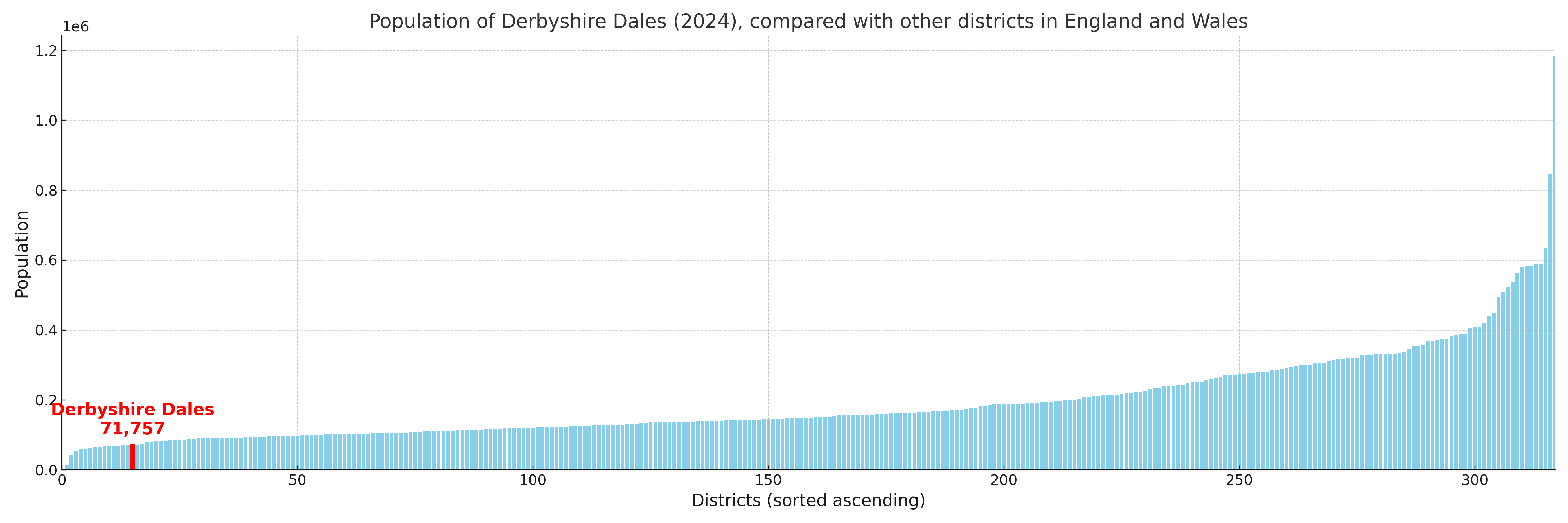
Derbyshire Dales compared with other districts in the UK
This section shows how Derbyshire Dales compares with other local authority districts in the UK, using a variety of measures and rankings.
Derbyshire Dales has 21 electoral wards.

Derbyshire Dales has a population of 71,757 (2024 mid-year estimate by ONS)
Population and Migration Trends in Derbyshire Dales
This chart shows the population trend for Derbyshire Dales from 2015 to 2024. It provides a quick overview of whether the local authority is growing, stable, or declining over time, and helps set context for the migration patterns shown below.
Population change is influenced by natural change (births minus deaths) and migration. The net migration chart below focuses on migration, separating internal migration (moves within the UK) from international migration (moves to and from abroad). Positive values indicate net inflows, while negative values indicate net outflows. The rate labels (per 1,000 residents) help compare migration intensity across years, even when the population size changes.
More local statistics and data for Derbyshire Dales can be found on the ONS statistics for Derbyshire Dales.
Latest news about Derbyshire Dales
Use the search box, or suggested search phrases, below to find recent news, council updates, planning stories, housing developments, transport changes, public services news, local elections, community issues and other local developments related to Derbyshire Dales. Results may include coverage from UK national, regional and local news websites, as well as official public-sector and local democracy sources.
- Derbyshire Dales council
- Derbyshire Dales planning
- Derbyshire Dales local elections
- Derbyshire Dales housing
- Derbyshire Dales transport
- Derbyshire Dales regeneration
- Derbyshire Dales public services