High Peak
§ This page gives an overview of the High Peak local authority district, bringing together key facts, maps, and data to help you quickly understand the area. This is one of 361 LAD profiles on Baseview.
Overview ⁞ High Peak is a dramatic landscape of moors, reservoirs, and gritstone edges, forming part of the Peak District National Park. The district includes the spa town of Buxton, known for its Georgian and Victorian architecture, natural spring waters, and grand Opera House. Glossop serves as a gateway to the Dark Peak, with rugged terrain and wild expanses ideal for hikers and climbers. Market towns like New Mills and Chapel-en-le-Frith sit among valleys and rivers, while the Kinder Scout plateau and Snake Pass highlight the area’s rugged natural beauty. Its mixture of heritage and untamed scenery makes High Peak a striking district.
High Peak Boundary Map
This map shows the official boundary of the High Peak local authority district, based on the latest geographic data published by the Office for National Statistics (ONS). It provides a clear view of the district’s extent and helps you understand how the area fits within the wider regional and national landscape.
Contains OS data © Crown copyright and database right 2025. Source: Office for National Statistics licensed under the Open Government Licence v3.0.
The administrative boundary of High Peak can also be viewed on OpenStreetMap: District Boundary of High Peak.
Key Facts about High Peak
What region is High Peak in? High Peak is in the East Midlands of England, a region within the UK.
What county is High Peak in? High Peak is located in the county of Derbyshire.
Is High Peak a city? No, High Peak is not a city. (Note: the UK has 76 officially designated cities.)
Who governs High Peak? The local authority for this district is: High Peak Borough Council - responsible for district-level services. Since Derbyshire is a two-tier area, county-level services are handled by: Derbyshire County Council.
▶ Official website of High Peak Borough Council 🔗 highpeak.gov.uk
Which police force covers High Peak? Policing in High Peak is provided by Derbyshire Constabulary 🔗 derbyshire.police.uk, which serves 9 local authority districts: Amber Valley ⁞ Bolsover ⁞ Chesterfield ⁞ Derby ⁞ Derbyshire Dales ⁞ Erewash ⁞ High Peak ⁞ North East Derbyshire ⁞ South Derbyshire.
Constituencies in High Peak
High Peak is divided into 1 parliamentary constituencies, listed below in alphabetical order.
A constituency is a specific geographical area that elects one Member of Parliament (MP) to represent them in the House of Commons. The United Kingdom is divided into 650 parliamentary constituencies. We have this list page for easy browsing of all UK parliamentary constituencies: List of Constituencies.
Wards in High Peak
High Peak is divided into 28 wards, listed below in alphabetical order.
- Barms
- Blackbrook
- Burbage
- Buxton Central
- Chapel East
- Chapel West
- Corbar
- Cote Heath
- Dinting
- Gamesley
- Hadfield North
- Hadfield South
- Hayfield
- Hope Valley
- Howard Town
- Limestone Peak
- New Mills East
- New Mills West
- Old Glossop
- Padfield
- Sett
- Simmondley
- St John's
- Stone Bench
- Temple
- Tintwistle
- Whaley Bridge
- Whitfield
In the UK, a ward is a subdivision of a local authority area, used mainly for electoral and statistical purposes. Defined by the ONS, wards represent the primary unit for local elections, each returning one or more councillors to the local council. Wards are also used as a key geography for presenting population and census data. We have this list page for easy browsing of all electoral wards: List of all Electoral Wards in the UK.
Parishes in High Peak
High Peak is part-parished: 22 civil parishes (listed A-Z below) alongside 3 unparished areas.
- Aston
- Bamford
- Brough and Shatton
- Castleton
- Chapel-en-le-Frith
- Charlesworth
- Chinley, Buxworth and Brownside
- Chisworth
- Derwent
- Edale
- Green Fairfield
- Hartington upper Quarter
- Hayfield
- Hope
- Hope Woodlands
- King Sterndale
- New Mills
- Peak Forest
- Thornhill
- Tintwistle
- Whaley Bridge
- Wormhill
A civil parish is the lowest tier of local government in England, used for villages, small towns, and suburbs. They have their own local authority, either a parish council or a parish meeting, which provides local services like managing parks, allotments, and streetlights, and represents the community's views to larger councils.
We have this list page for easy browsing of all parishes: List of Civil Parishes in England and Wales.
Post Towns in High Peak
Below is a list of post towns in High Peak, grouped by postcode area:
- SK ▸ Buxton (SK17) ⁞ Glossop (SK13) ⁞ High Peak (SK22 / SK23)
The UK postal hierarchy begins with broad postcode areas (such as “CB” or “M”), which are divided into smaller postcode districts (such as “CB8” or “M1”) to support accurate mail routing. Each postal address is anchored by a designated post town, the official locality name used in the UK postcode system, which operates independently from Local Authority Districts —the administrative boundaries used for council tax and local government services. Because they serve different purposes, a property’s postal address and its local authority district do not always align exactly.
Built-up Areas in High Peak
High Peak covers 22 built-up areas, listed below in alphabetical order.
- Bamford
- Batham Gate
- Birch Vale
- Bradwell (Derbyshire Dales) *
- Broadbottom *
- Buxton (High Peak)
- Castleton (High Peak)
- Chapel-en-le-Frith
- Charlesworth
- Chinley
- Dove Holes
- Furness Vale
- Gamesley
- Glossop
- Hadfield *
- Harpur Hill
- Hayfield
- Hope (High Peak)
- New Mills *
- Padfield
- Tunstead
- Whaley Bridge
In the UK, a Built-up Area (BUA) is a continuous urban area of at least 20 hectares (0.2 km²), defined by the ONS as land where buildings are generally no more than 200 metres apart, such as towns, cities, or large villages. (Note: A BUA name marked with an asterisk (*) indicates that the area is situated partly in the district of High Peak.)
We have this list page for easy browsing of all built-up areas: List of all Built-up Areas in GB.
Railway Stations in High Peak
High Peak is served by a number of National Rail stations, providing rail connections to nearby towns, cities, and destinations across Great Britain. The railway stations listed below are located within the High Peak Local Authority District and are grouped by train operating company for clarity.
- Northern Trains ▸ Glossop (SK13 8BS) ⁞ Buxton (SK17 6AQ) ⁞ New Mills Newtown (SK22 3JP) ⁞ Edale (S33 7ZN) ⁞ New Mills Central (SK22 3JB) ⁞ Whaley Bridge (SK23 7AA) ⁞ Chinley (SK23 6AR) ⁞ Hope (Derbyshire) (S33 6RD) ⁞ Dinting (SK13 9EB) ⁞ Chapel-En-Le-Frith (SK23 0XT) ⁞ Strines (SK22 3AY) ⁞ Dove Holes (SK17 8DJ)
This is a district-level view only. For a complete list of all National Rail stations across Great Britain, see the UK National Rail Stations Directory.
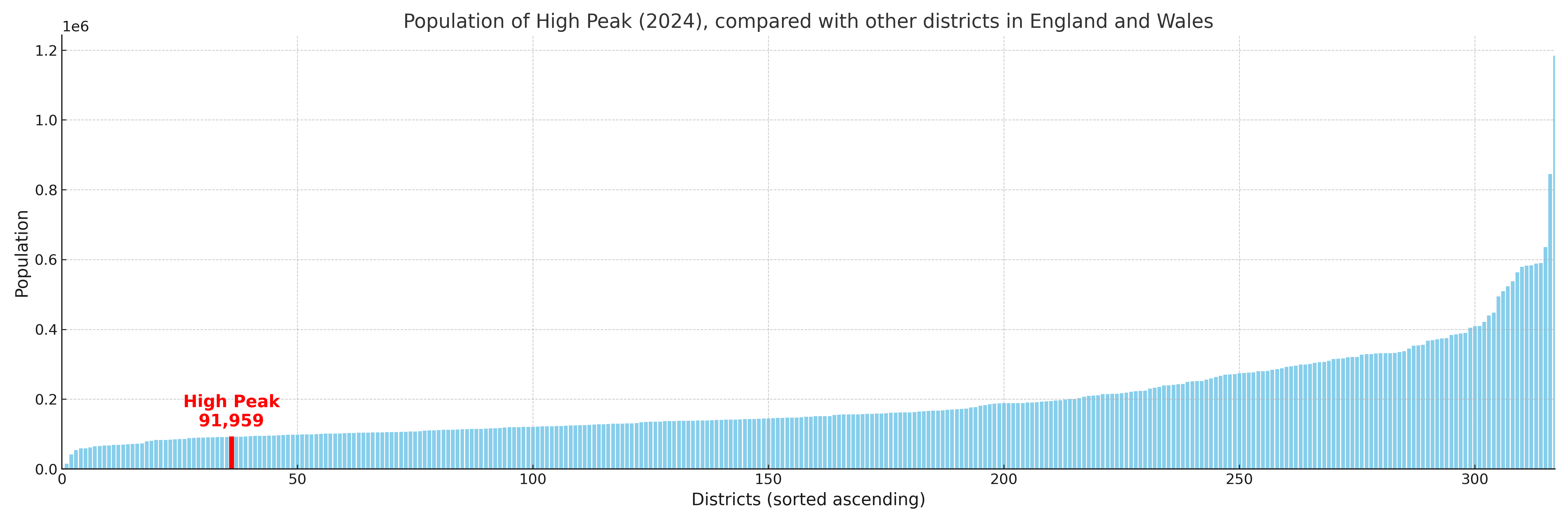
High Peak compared with other districts in the UK
This section shows how High Peak compares with other local authority districts in the UK, using a variety of measures and rankings.
High Peak has 28 electoral wards.

High Peak has a population of 91,959 (2024 mid-year estimate by ONS)
Population and Migration Trends in High Peak
This chart shows the population trend for High Peak from 2015 to 2024. It provides a quick overview of whether the local authority is growing, stable, or declining over time, and helps set context for the migration patterns shown below.
Population change is influenced by natural change (births minus deaths) and migration. The net migration chart below focuses on migration, separating internal migration (moves within the UK) from international migration (moves to and from abroad). Positive values indicate net inflows, while negative values indicate net outflows. The rate labels (per 1,000 residents) help compare migration intensity across years, even when the population size changes.
More local statistics and data for High Peak can be found on the ONS statistics for High Peak.
Latest news about High Peak
Use the search box, or suggested search phrases, below to find recent news, council updates, planning stories, housing developments, transport changes, public services news, local elections, community issues and other local developments related to High Peak. Results may include coverage from UK national, regional and local news websites, as well as official public-sector and local democracy sources.
- High Peak council
- High Peak planning
- High Peak local elections
- High Peak housing
- High Peak transport
- High Peak regeneration
- High Peak public services