Blaby
§ This page gives an overview of the Blaby local authority district, bringing together key facts, maps, and data to help you quickly understand the area. This is one of 361 LAD profiles on Baseview.
Overview ⁞ Blaby in Leicestershire combines suburban communities with green countryside just south of Leicester. The district includes the town of Wigston and villages such as Narborough, Enderby, and Countesthorpe, each with local character. Known for its riverside meadows and parks, Blaby also has attractions like Fosse Park, one of the region’s major retail centres. The Grand Union Canal runs through the area, offering walking and cycling routes. With rolling farmland, woodland, and a mix of modern development and historic churches, Blaby reflects both the rural and suburban character of Leicestershire.
Blaby Boundary Map
This map shows the official boundary of the Blaby local authority district, based on the latest geographic data published by the Office for National Statistics (ONS). It provides a clear view of the district’s extent and helps you understand how the area fits within the wider regional and national landscape.
Contains OS data © Crown copyright and database right 2025. Source: Office for National Statistics licensed under the Open Government Licence v3.0.
The administrative boundary of Blaby can also be viewed on OpenStreetMap: District Boundary of Blaby.
Key Facts about Blaby
What region is Blaby in? Blaby is in the East Midlands of England, a region within the UK.
What county is Blaby in? Blaby is located in the county of Leicestershire.
Is Blaby a city? No, Blaby is not a city. (Note: the UK has 76 officially designated cities.)
Who governs Blaby? The local authority for this district is: Blaby District Council - responsible for district-level services. Since Leicestershire is a two-tier area, county-level services are handled by: Leicestershire County Council.
▶ Official website of Blaby District Council 🔗 blaby.gov.uk
Which police force covers Blaby? Policing in Blaby is provided by Leicestershire Police 🔗 leics.police.uk, which serves 9 local authority districts: Blaby ⁞ Charnwood ⁞ Harborough ⁞ Hinckley and Bosworth ⁞ Leicester ⁞ Melton ⁞ North West Leicestershire ⁞ Oadby and Wigston ⁞ Rutland.
Constituencies in Blaby
Blaby is divided into 2 parliamentary constituencies, listed below in alphabetical order.
A constituency is a specific geographical area that elects one Member of Parliament (MP) to represent them in the House of Commons. The United Kingdom is divided into 650 parliamentary constituencies. We have this list page for easy browsing of all UK parliamentary constituencies: List of Constituencies.
Wards in Blaby
Blaby is divided into 17 wards, listed below in alphabetical order.
- Blaby
- Braunstone Millfield
- Braunstone Ravenhurst
- Cosby & South Whetstone
- Countesthorpe
- Enderby
- Fosse Highcross
- Fosse Normanton
- Fosse Stoney Cove
- Glen Parva
- Glenfield Ellis
- Glenfield Faire
- Kirby Muxloe
- Leicester Forest & Lubbesthorpe
- Narborough & Littlethorpe
- North Whetstone
- Thorpe Astley & St Mary's
In the UK, a ward is a subdivision of a local authority area, used mainly for electoral and statistical purposes. Defined by the ONS, wards represent the primary unit for local elections, each returning one or more councillors to the local council. Wards are also used as a key geography for presenting population and census data. We have this list page for easy browsing of all electoral wards: List of all Electoral Wards in the UK.
Parishes in Blaby
Blaby is part-parished: 24 civil parishes (listed A-Z below) alongside 1 unparished areas.
- Aston Flamville
- Blaby
- Braunstone
- Cosby
- Countesthorpe
- Croft
- Elmesthorpe
- Enderby
- Glen Parva
- Glenfields
- Huncote
- Kilby
- Kirby Muxloe
- Leicester Forest East
- Leicester Forest West
- Lubbesthorpe
- Narborough
- Potters Marston
- Sapcote
- Sharnford
- Stoney Stanton
- Thurlaston
- Whetstone
- Wigston Parva
A civil parish is the lowest tier of local government in England, used for villages, small towns, and suburbs. They have their own local authority, either a parish council or a parish meeting, which provides local services like managing parks, allotments, and streetlights, and represents the community's views to larger councils.
We have this list page for easy browsing of all parishes: List of Civil Parishes in England and Wales.
Built-up Areas in Blaby
Blaby covers 16 built-up areas, listed below in alphabetical order.
- Blaby and Whetstone
- Cosby
- Countesthorpe
- Croft (Blaby)
- Earl Shilton *
- Elmesthorpe *
- Enderby and Narborough
- Huncote
- Leicester *
- Leicester Forest East and Kirby Muxloe *
- Littlethorpe
- Sapcote
- Sharnford
- Stoney Stanton
- Thurlaston (Blaby)
- Wigston *
In the UK, a Built-up Area (BUA) is a continuous urban area of at least 20 hectares (0.2 km²), defined by the ONS as land where buildings are generally no more than 200 metres apart, such as towns, cities, or large villages. (Note: A BUA name marked with an asterisk (*) indicates that the area is situated partly in the district of Blaby.)
We have this list page for easy browsing of all built-up areas: List of all Built-up Areas in GB.
Railway Stations in Blaby
Blaby is served by a number of National Rail stations, providing rail connections to nearby towns, cities, and destinations across Great Britain. The railway stations listed below are located within the Blaby Local Authority District and are grouped by train operating company for clarity.
East Midlands Railway ▸ Narborough (LE19 2HR)
This is a district-level view only. For a complete list of all National Rail stations across Great Britain, see the UK National Rail Stations Directory.
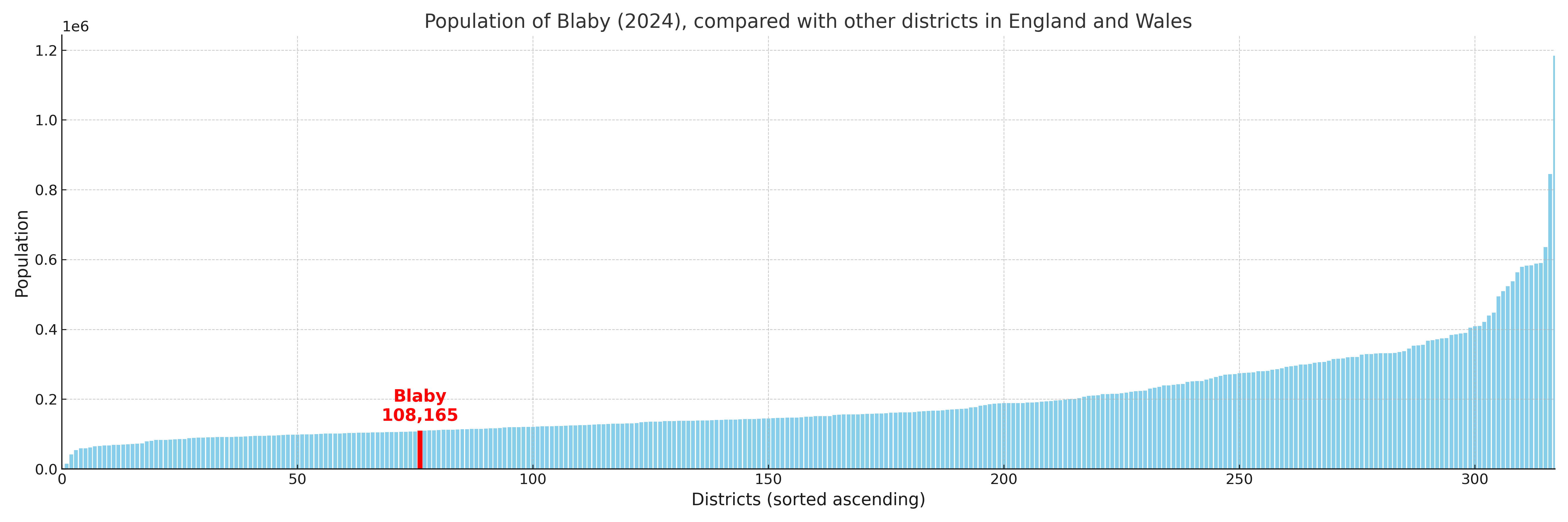
Blaby compared with other districts in the UK
This section shows how Blaby compares with other local authority districts in the UK, using a variety of measures and rankings.
Blaby has 17 electoral wards.

Blaby has a population of 108,165 (2024 mid-year estimate by ONS)
Population and Migration Trends in Blaby
This chart shows the population trend for Blaby from 2015 to 2024. It provides a quick overview of whether the local authority is growing, stable, or declining over time, and helps set context for the migration patterns shown below.
Population change is influenced by natural change (births minus deaths) and migration. The net migration chart below focuses on migration, separating internal migration (moves within the UK) from international migration (moves to and from abroad). Positive values indicate net inflows, while negative values indicate net outflows. The rate labels (per 1,000 residents) help compare migration intensity across years, even when the population size changes.
More local statistics and data for Blaby can be found on the ONS statistics for Blaby.
Latest news about Blaby
Use the search box, or suggested search phrases, below to find recent news, council updates, planning stories, housing developments, transport changes, public services news, local elections, community issues and other local developments related to Blaby. Results may include coverage from UK national, regional and local news websites, as well as official public-sector and local democracy sources.
- Blaby council
- Blaby planning
- Blaby local elections
- Blaby housing
- Blaby transport
- Blaby regeneration
- Blaby public services