West Lindsey
§ This page gives an overview of the West Lindsey local authority district, bringing together key facts, maps, and data to help you quickly understand the area. This is one of 361 LAD profiles on Baseview.
Overview ⁞ West Lindsey covers a large part of Lincolnshire stretching from the River Trent in the west to the Lincolnshire Wolds in the east. Gainsborough, its main town, sits on the Trent and is home to Gainsborough Old Hall, a medieval manor. The district includes Market Rasen, known for its racecourse, and Caistor, a historic town with Roman origins. Much of the landscape is agricultural, interspersed with Wolds villages and scenic countryside. The mix of historic market centres, riverside communities, and rural landscapes makes West Lindsey a district with deep heritage and varied scenery.
West Lindsey Boundary Map
This map shows the official boundary of the West Lindsey local authority district, based on the latest geographic data published by the Office for National Statistics (ONS). It provides a clear view of the district’s extent and helps you understand how the area fits within the wider regional and national landscape.
Contains OS data © Crown copyright and database right 2025. Source: Office for National Statistics licensed under the Open Government Licence v3.0.
The administrative boundary of West Lindsey can also be viewed on OpenStreetMap: District Boundary of West Lindsey.
Key Facts about West Lindsey
What region is West Lindsey in? West Lindsey is in the East Midlands of England, a region within the UK.
What county is West Lindsey in? West Lindsey is located in the county of Lincolnshire.
Is West Lindsey a city? No, West Lindsey is not a city. (Note: the UK has 76 officially designated cities.)
Who governs West Lindsey? The local authority for this district is: West Lindsey District Council - responsible for district-level services. Since Lincolnshire is a two-tier area, county-level services are handled by: Lincolnshire County Council.
▶ Official website of West Lindsey District Council 🔗 west-lindsey.gov.uk
Which police force covers West Lindsey? Policing in West Lindsey is provided by Lincolnshire Police 🔗 lincs.police.uk, which serves 7 local authority districts: Boston ⁞ East Lindsey ⁞ Lincoln ⁞ North Kesteven ⁞ South Holland ⁞ South Kesteven ⁞ West Lindsey.
Constituencies in West Lindsey
West Lindsey is divided into 1 parliamentary constituencies, listed below in alphabetical order.
A constituency is a specific geographical area that elects one Member of Parliament (MP) to represent them in the House of Commons. The United Kingdom is divided into 650 parliamentary constituencies. We have this list page for easy browsing of all UK parliamentary constituencies: List of Constituencies.
Wards in West Lindsey
West Lindsey is divided into 20 wards, listed below in alphabetical order.
- Bardney
- Caistor and Yarborough
- Cherry Willingham
- Dunholme and Welton
- Gainsborough East
- Gainsborough North
- Gainsborough South-West
- Hemswell
- Kelsey Wold
- Lea
- Market Rasen
- Nettleham
- Saxilby
- Scampton
- Scotter and Blyton
- Stow
- Sudbrooke
- Torksey
- Waddingham and Spital
- Wold View
In the UK, a ward is a subdivision of a local authority area, used mainly for electoral and statistical purposes. Defined by the ONS, wards represent the primary unit for local elections, each returning one or more councillors to the local council. Wards are also used as a key geography for presenting population and census data. We have this list page for easy browsing of all electoral wards: List of all Electoral Wards in the UK.
Parishes in West Lindsey
West Lindsey is fully parished: 128 civil parishes, listed A-Z below.
- Aisthorpe
- Apley
- Bardney
- Barlings
- Bigby
- Bishop Norton
- Blyborough
- Blyton
- Brampton
- Brattleby
- Broadholme
- Brocklesby
- Brookenby
- Broxholme
- Bullington
- Burton
- Buslingthorpe
- Cabourne
- Caenby
- Caistor
- Cammeringham
- Cherry Willingham
- Claxby
- Cold Hanworth
- Corringham
- Dunholme
- East Ferry
- East Stockwith
- Faldingworth
- Fenton
- Fillingham
- Fiskerton
- Friesthorpe
- Fulnetby
- Gainsborough
- Gate Burton
- Glentham
- Glentworth
- Goltho
- Grange de Lings
- Grasby
- Grayingham
- Great Limber
- Greetwell
- Hackthorn
- Hardwick
- Harpswell
- Heapham
- Hemswell
- Hemswell Cliff
- Holton cum Beckering
- Holton le Moor
- Ingham
- Keelby
- Kettlethorpe
- Kexby
- Kirmond le Mire
- Knaith
- Laughton
- Lea
- Legsby
- Linwood
- Lissington
- Market Rasen
- Marton
- Middle Rasen
- Morton
- Nettleham
- Nettleton
- Newball
- Newton on Trent
- Normanby by Spital
- Normanby le Wold
- North Carlton
- North Kelsey
- North Willingham
- Northorpe
- Osgodby
- Owersby
- Owmby-by-Spital
- Pilham
- Rand
- Reepham
- Riby
- Riseholme
- Rothwell
- Saxby
- Saxilby with Ingleby
- Scampton
- Scothern
- Scotter
- Scotton
- Searby cum Owmby
- Sixhills
- Snarford
- Snelland
- Snitterby
- Somerby
- South Carlton
- South Kelsey
- Spridlington
- Springthorpe
- Stainfield
- Stainton by Langworth
- Stainton le Vale
- Stow
- Sturton by Stow
- Sudbrooke
- Swallow
- Swinhope
- Tealby
- Thonock
- Thoresway
- Thorganby
- Thorpe in the Fallows
- Toft Newton
- Torksey
- Upton
- Waddingham
- Walesby
- Walkerith
- Welton
- West Firsby
- West Rasen
- Wickenby
- Wildsworth
- Willingham
- Willoughton
A civil parish is the lowest tier of local government in England, used for villages, small towns, and suburbs. They have their own local authority, either a parish council or a parish meeting, which provides local services like managing parks, allotments, and streetlights, and represents the community's views to larger councils.
We have this list page for easy browsing of all parishes: List of Civil Parishes in England and Wales.
Post Towns in West Lindsey
Below is a list of post towns in West Lindsey, grouped by postcode area:
- DN ▸ Gainsborough (DN21)
- LN ▸ Market Rasen (LN7 / LN8)
The UK postal hierarchy begins with broad postcode areas (such as “CB” or “M”), which are divided into smaller postcode districts (such as “CB8” or “M1”) to support accurate mail routing. Each postal address is anchored by a designated post town, the official locality name used in the UK postcode system, which operates independently from Local Authority Districts —the administrative boundaries used for council tax and local government services. Because they serve different purposes, a property’s postal address and its local authority district do not always align exactly.
Built-up Areas in West Lindsey
West Lindsey covers 55 built-up areas, listed below in alphabetical order.
- Aisthorpe and Brattleby
- Bardney *
- Blyton
- Bole *
- Brookenby
- Burton Waters *
- Burton-by-Lincoln
- Caistor
- Cherry Willingham
- Corringham
- Dunholme
- Faldingworth
- Fiskerton (West Lindsey)
- Gainsborough
- Glentham
- Grasby
- Heapham
- Hemswell
- Hemswell Cliff
- Ingham (West Lindsey)
- Keelby
- Kexby
- Langworth
- Laughterton
- Lea (West Lindsey)
- Lincoln *
- Market Rasen
- Marton (West Lindsey)
- Middle Rasen
- Nettleham
- Nettleton
- Newton on Trent
- Normanby-by-Spital
- North Greetwell
- North Kelsey
- Osgodby (West Lindsey)
- Reepham (West Lindsey)
- Riseholme
- Saxilby
- Scampton
- Scothern
- Scotter
- Scotton (West Lindsey)
- South Kelsey
- Stow (West Lindsey)
- Sturton by Stow
- Sudbrooke
- Tealby
- Torksey Lock
- Upton (West Lindsey)
- Waddingham
- Welton (West Lindsey)
- Wickenby
- Willingham by Stow
- Willoughton
In the UK, a Built-up Area (BUA) is a continuous urban area of at least 20 hectares (0.2 km²), defined by the ONS as land where buildings are generally no more than 200 metres apart, such as towns, cities, or large villages. (Note: A BUA name marked with an asterisk (*) indicates that the area is situated partly in the district of West Lindsey.)
We have this list page for easy browsing of all built-up areas: List of all Built-up Areas in GB.
Railway Stations in West Lindsey
West Lindsey is served by a number of National Rail stations, providing rail connections to nearby towns, cities, and destinations across Great Britain. The railway stations listed below are located within the West Lindsey Local Authority District and are grouped by train operating company for clarity.
- East Midlands Railway ▸ Gainsborough Lea Road (DN21 1AH) ⁞ Saxilby (LN1 2NS) ⁞ Market Rasen (LN8 3AQ)
- Northern Trains ▸ Gainsborough Central (DN21 1XR)
This is a district-level view only. For a complete list of all National Rail stations across Great Britain, see the UK National Rail Stations Directory.
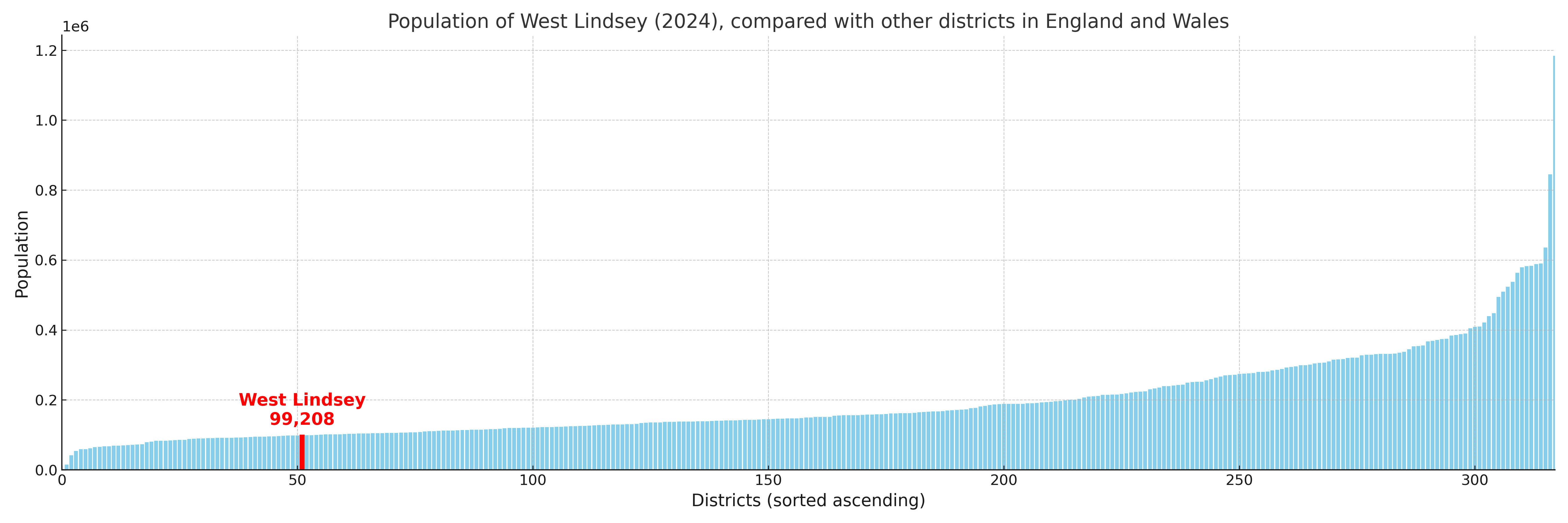
West Lindsey compared with other districts in the UK
This section shows how West Lindsey compares with other local authority districts in the UK, using a variety of measures and rankings.
West Lindsey has 20 electoral wards.

West Lindsey has a population of 99,208 (2024 mid-year estimate by ONS)
Population and Migration Trends in West Lindsey
This chart shows the population trend for West Lindsey from 2015 to 2024. It provides a quick overview of whether the local authority is growing, stable, or declining over time, and helps set context for the migration patterns shown below.
Population change is influenced by natural change (births minus deaths) and migration. The net migration chart below focuses on migration, separating internal migration (moves within the UK) from international migration (moves to and from abroad). Positive values indicate net inflows, while negative values indicate net outflows. The rate labels (per 1,000 residents) help compare migration intensity across years, even when the population size changes.
More local statistics and data for West Lindsey can be found on the ONS statistics for West Lindsey.
Latest news about West Lindsey
Use the search box, or suggested search phrases, below to find recent news, council updates, planning stories, housing developments, transport changes, public services news, local elections, community issues and other local developments related to West Lindsey. Results may include coverage from UK national, regional and local news websites, as well as official public-sector and local democracy sources.
- West Lindsey council
- West Lindsey planning
- West Lindsey local elections
- West Lindsey housing
- West Lindsey transport
- West Lindsey regeneration
- West Lindsey public services