Bath and North East Somerset
§ This page gives an overview of the Bath and North East Somerset local authority district, bringing together key facts, maps, and data to help you quickly understand the area. This is one of 361 LAD profiles on Baseview.
Overview ⁞ Bath and North East Somerset combines the historic city of Bath with surrounding countryside and villages. Bath, a UNESCO World Heritage Site, is renowned for its Roman Baths, Georgian crescents, and abbey. The River Avon runs through the city, with hills rising around it, offering scenic views. The surrounding area includes Chew Valley Lake, historic towns like Keynsham, and rural landscapes of rolling hills, woodland, and farmland, forming a mix of cultural heritage and natural beauty.
Bath and North East Somerset Boundary Map
This map shows the official boundary of the Bath and North East Somerset local authority district, based on the latest geographic data published by the Office for National Statistics (ONS). It provides a clear view of the district’s extent and helps you understand how the area fits within the wider regional and national landscape.
Contains OS data © Crown copyright and database right 2025. Source: Office for National Statistics licensed under the Open Government Licence v3.0.
The administrative boundary of Bath and North East Somerset can also be viewed on OpenStreetMap: District Boundary of Bath and North East Somerset.
Key Facts about Bath and North East Somerset
What region are Bath and North East Somerset in? Bath and North East Somerset are in the South West of England, a region within the UK.
What county is Bath and North East Somerset in? Bath and North East Somerset is in the county of Somerset.
Is Bath and North East Somerset a city? Yes, Bath and North East Somerset is a city. Bath and North East Somerset holds official city status as one of the 76 designated cities in the UK.
Who governs Bath and North East Somerset? The local government for this district is: Bath and North East Somerset Council (Unitary Authority).
▶ Official website of Bath and North East Somerset Council 🔗 bathnes.gov.uk
Which police force covers Bath and North East Somerset? Policing in Bath and North East Somerset is provided by Avon and Somerset Constabulary 🔗 avonandsomerset.police.uk, which serves 5 local authority districts: Bath and North East Somerset ⁞ Bristol, City of ⁞ North Somerset ⁞ Somerset ⁞ South Gloucestershire.
Constituencies in Bath and North East Somerset
Bath and North East Somerset is divided into 3 parliamentary constituencies, listed below in alphabetical order.
A constituency is a specific geographical area that elects one Member of Parliament (MP) to represent them in the House of Commons. The United Kingdom is divided into 650 parliamentary constituencies. We have this list page for easy browsing of all UK parliamentary constituencies: List of Constituencies.
Wards in Bath and North East Somerset
Bath and North East Somerset is divided into 33 wards, listed below in alphabetical order.
- Bathavon North
- Bathavon South
- Bathwick
- Chew Valley
- Clutton & Farmborough
- Combe Down
- High Littleton
- Keynsham East
- Keynsham North
- Keynsham South
- Kingsmead
- Lambridge
- Lansdown
- Mendip
- Midsomer Norton North
- Midsomer Norton Redfield
- Moorlands
- Newbridge
- Odd Down
- Oldfield Park
- Paulton
- Peasedown
- Publow & Whitchurch
- Radstock
- Saltford
- Southdown
- Timsbury
- Twerton
- Walcot
- Westfield
- Westmoreland
- Weston
- Widcombe & Lyncombe
In the UK, a ward is a subdivision of a local authority area, used mainly for electoral and statistical purposes. Defined by the ONS, wards represent the primary unit for local elections, each returning one or more councillors to the local council. Wards are also used as a key geography for presenting population and census data. We have this list page for easy browsing of all electoral wards: List of all Electoral Wards in the UK.
Parishes in Bath and North East Somerset
Bath and North East Somerset is part-parished: 51 civil parishes (listed A-Z below) alongside 2 unparished areas.
- Bathampton
- Batheaston
- Bathford
- Camerton
- Charlcombe
- Chelwood
- Chew Magna
- Chew Stoke
- Claverton
- Clutton
- Combe Hay
- Compton Dando
- Compton Martin
- Corston
- Dunkerton and Tunley
- East Harptree
- Englishcombe
- Farmborough
- Farrington Gurney
- Freshford
- High Littleton
- Hinton Blewett
- Hinton Charterhouse
- Kelston
- Keynsham
- Marksbury
- Midsomer Norton
- Monkton Combe
- Nempnett Thrubwell
- Newton St. Loe
- North Stoke
- Norton Malreward
- Paulton
- Peasedown St. John
- Priston
- Publow
- Radstock
- Saltford
- Shoscombe
- Southstoke
- St. Catherine
- Stanton Drew
- Stowey-Sutton
- Swainswick
- Temple Cloud with Cameley
- Timsbury
- Ubley
- Wellow
- West Harptree
- Westfield
- Whitchurch
A civil parish is the lowest tier of local government in England, used for villages, small towns, and suburbs. They have their own local authority, either a parish council or a parish meeting, which provides local services like managing parks, allotments, and streetlights, and represents the community's views to larger councils.
We have this list page for easy browsing of all parishes: List of Civil Parishes in England and Wales.
Post Towns in Bath and North East Somerset
Below is a list of post towns in Bath and North East Somerset, grouped by postcode area:
- BA ▸ Bath (BA1 / BA2) ⁞ Radstock (BA3)
The UK postal hierarchy begins with broad postcode areas (such as “CB” or “M”), which are divided into smaller postcode districts (such as “CB8” or “M1”) to support accurate mail routing. Each postal address is anchored by a designated post town, the official locality name used in the UK postcode system, which operates independently from Local Authority Districts —the administrative boundaries used for council tax and local government services. Because they serve different purposes, a property’s postal address and its local authority district do not always align exactly.
Built-up Areas in Bath and North East Somerset
Bath and North East Somerset covers 33 built-up areas, listed below in alphabetical order.
- Bath
- Bathampton
- Batheaston
- Bathford
- Bishop Sutton
- Bristol *
- Chew Magna
- Chew Stoke
- Clutton
- Compton Martin
- Corston (Bath and North East Somerset)
- East Harptree
- Farmborough
- Farrington Gurney *
- Freshford
- Hallatrow
- High Littleton
- Keynsham *
- Limpley Stoke *
- Midsomer Norton *
- Monkton Combe *
- Newton St Loe
- Paulton
- Peasedown St John
- Pensford
- Radstock *
- Saltford
- Temple Cloud
- Timsbury (Bath and North East Somerset)
- Ubley
- Upton Cheyney *
- Wellow (Bath and North East Somerset)
- Whitchurch (Bath and North East Somerset) *
In the UK, a Built-up Area (BUA) is a continuous urban area of at least 20 hectares (0.2 km²), defined by the ONS as land where buildings are generally no more than 200 metres apart, such as towns, cities, or large villages. (Note: A BUA name marked with an asterisk (*) indicates that the area is situated partly in the district of Bath and North East Somerset.)
We have this list page for easy browsing of all built-up areas: List of all Built-up Areas in GB.
Railway Stations in Bath and North East Somerset
Bath and North East Somerset is served by a number of National Rail stations, providing rail connections to nearby towns, cities, and destinations across Great Britain. The railway stations listed below are located within the Bath and North East Somerset Local Authority District and are grouped by train operating company for clarity.
- Great Western Railway ▸ Bath Spa (BA1 1SU) ⁞ Keynsham (BS31 2BN) ⁞ Oldfield Park (BA2 3RS) ⁞ Freshford (BA2 7WQ)
This is a district-level view only. For a complete list of all National Rail stations across Great Britain, see the UK National Rail Stations Directory.
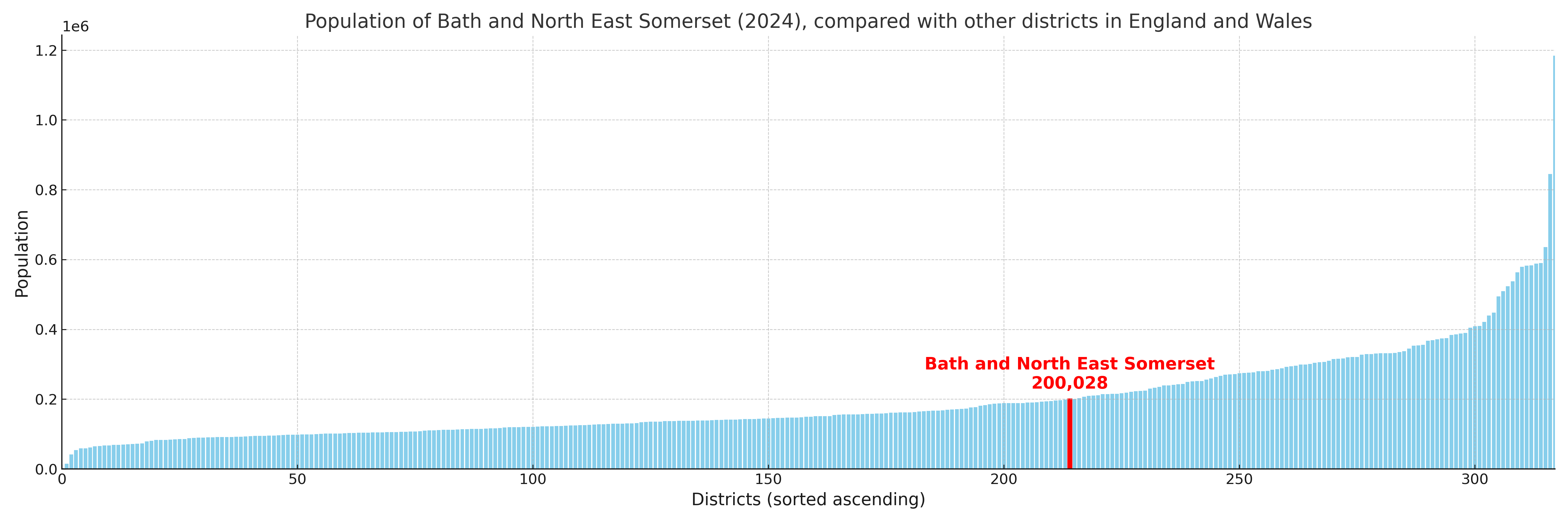
Bath and North East Somerset compared with other districts in the UK
This section shows how Bath and North East Somerset compares with other local authority districts in the UK, using a variety of measures and rankings.
Bath and North East Somerset has 33 electoral wards.

Bath and North East Somerset has a population of 200,028 (2024 mid-year estimate by ONS)
Population and Migration Trends in Bath and North East Somerset
This chart shows the population trend for Bath and North East Somerset from 2015 to 2024. It provides a quick overview of whether the local authority is growing, stable, or declining over time, and helps set context for the migration patterns shown below.
Population change is influenced by natural change (births minus deaths) and migration. The net migration chart below focuses on migration, separating internal migration (moves within the UK) from international migration (moves to and from abroad). Positive values indicate net inflows, while negative values indicate net outflows. The rate labels (per 1,000 residents) help compare migration intensity across years, even when the population size changes.
More local statistics and data for Bath and North East Somerset can be found on the ONS statistics for Bath and North East Somerset.
Latest news about Bath and North East Somerset
Use the search box, or suggested search phrases, below to find recent news, council updates, planning stories, housing developments, transport changes, public services news, local elections, community issues and other local developments related to Bath and North East Somerset. Results may include coverage from UK national, regional and local news websites, as well as official public-sector and local democracy sources.
- Bath and North East Somerset council
- Bath and North East Somerset planning
- Bath and North East Somerset local elections
- Bath and North East Somerset housing
- Bath and North East Somerset transport
- Bath and North East Somerset regeneration
- Bath and North East Somerset public services