Cornwall
§ This page gives an overview of the Cornwall local authority district, bringing together key facts, maps, and data to help you quickly understand the area. This is one of 361 LAD profiles on Baseview.
Overview ⁞ Cornwall forms the southwestern tip of mainland England and includes the Isles of Scilly within its ceremonial boundary. Known for its Celtic heritage, dramatic coastline, and unique culture, Cornwall has a distinct identity, including its own Cornish language revival. The area is heavily reliant on tourism, agriculture, and creative industries. Governed by the Cornwall Council unitary authority, the Isles of Scilly are administered separately by the Council of the Isles of Scilly.
Cornwall Boundary Map
This map shows the official boundary of the Cornwall local authority district, based on the latest geographic data published by the Office for National Statistics (ONS). It provides a clear view of the district’s extent and helps you understand how the area fits within the wider regional and national landscape.
Contains OS data © Crown copyright and database right 2025. Source: Office for National Statistics licensed under the Open Government Licence v3.0.
The administrative boundary of Cornwall can also be viewed on OpenStreetMap: District Boundary of Cornwall.
Key Facts about Cornwall
What region is Cornwall in? Cornwall is in the South West of England, a region within the UK.
What county is Cornwall in? Cornwall is in the county of Cornwall.
Is Cornwall a city? Yes, Cornwall is a city. Cornwall holds official city status as one of the 76 designated cities in the UK.
Who governs Cornwall? The local government for this district is: Cornwall Council (Unitary Authority).
▶ Official website of Cornwall Council 🔗 cornwall.gov.uk
Which police force covers Cornwall? Policing in Cornwall is provided by Devon & Cornwall Police 🔗 devon-cornwall.police.uk, which serves 12 local authority districts: Cornwall ⁞ East Devon ⁞ Exeter ⁞ Isles of Scilly ⁞ Mid Devon ⁞ North Devon ⁞ Plymouth ⁞ South Hams ⁞ Teignbridge ⁞ Torbay ⁞ Torridge ⁞ West Devon.
Cornwall in International Geographies
In the International Territorial Levels (ITLs) hierarchy, Cornwall is within an ITLs Level 3 area:
- (ITL 1) South West
- (ITL 2) ⇒ Cornwall and Isles of Scilly
- (ITL 3) ⇒⇒ Cornwall and Isles of Scilly
The International Territorial Levels are used by OECD member countries for statistical purposes to classify administrative areas. We have this listable page for easy browsing of ITL names and codes: International Territorial Levels.
Constituencies in Cornwall
Cornwall is divided into 6 parliamentary constituencies, listed below in alphabetical order.
- Camborne and Redruth
- North Cornwall
- South East Cornwall
- St Austell and Newquay
- St Ives
- Truro and Falmouth
A constituency is a specific geographical area that elects one Member of Parliament (MP) to represent them in the House of Commons. The United Kingdom is divided into 650 parliamentary constituencies. We have this list page for easy browsing of all UK parliamentary constituencies: List of Constituencies.
Wards in Cornwall
Cornwall is divided into 87 wards, listed below in alphabetical order.
- Altarnun & Stoke Climsland
- Bodmin St Mary's & St Leonard
- Bodmin St Petroc's
- Bude
- Callington & St Dominic
- Calstock
- Camborne Roskear & Tuckingmill
- Camborne Trelowarren
- Camborne West & Treswithian
- Camelford & Boscastle
- Constantine, Mabe & Mawnan
- Crowan, Sithney & Wendron
- Falmouth Arwenack
- Falmouth Boslowick
- Falmouth Penwerris
- Falmouth Trescobeas & Budock
- Feock & Kea
- Four Lanes, Beacon & Troon
- Fowey, Tywardreath & Par
- Gloweth, Malabar & Shortlanesend
- Gwinear-Gwithian & Hayle East
- Hayle West
- Helston North
- Helston South & Meneage
- Illogan & Portreath
- Land's End
- Lanivet, Blisland & Bodmin St Lawrence
- Lanner, Stithians & Gwennap
- Launceston North & North Petherwin
- Launceston South
- Liskeard Central
- Liskeard South & Dobwalls
- Long Rock, Marazion & St Erth
- Looe East & Deviock
- Looe West, Pelynt, Lansallos & Lanteglos
- Lostwithiel & Lanreath
- Ludgvan, Madron, Gulval & Heamoor
- Lynher
- Mevagissey & St Austell Bay
- Mousehole, Newlyn & St Buryan
- Mullion & St Keverne
- Mylor, Perranarworthal & Ponsanooth
- Newquay Central & Pentire
- Newquay Porth & Tretherras
- Newquay Trenance
- Padstow
- Penryn
- Penwithick & Boscoppa
- Penzance East
- Penzance Promenade
- Perranporth
- Pool & Tehidy
- Porthleven, Breage & Germoe
- Poundstock
- Probus & St Erme
- Rame Peninsula & St Germans
- Redruth Central, Carharrack & St Day
- Redruth North
- Redruth South
- Roche & Bugle
- Saltash Essa
- Saltash Tamar
- Saltash Trematon & Landrake
- St Agnes
- St Austell Bethel & Holmbush
- St Austell Central & Gover
- St Austell Poltair & Mount Charles
- St Blazey
- St Cleer & Menheniot
- St Columb Major, St Mawgan & St Wenn
- St Columb Minor & Colan
- St Dennis & St Enoder
- St Goran, Tregony & the Roseland
- St Ives East, Lelant & Carbis Bay
- St Ives West & Towednack
- St Mewan & Grampound
- St Newlyn East, Cubert & Goonhavern
- St Stephen-in-Brannel
- St Teath & Tintagel
- Stratton, Kilkhampton & Morwenstow
- Threemilestone & Chacewater
- Torpoint
- Truro Boscawen & Redannick
- Truro Moresk & Trehaverne
- Truro Tregolls
- Wadebridge East & St Minver
- Wadebridge West & St Mabyn
In the UK, a ward is a subdivision of a local authority area, used mainly for electoral and statistical purposes. Defined by the ONS, wards represent the primary unit for local elections, each returning one or more councillors to the local council. Wards are also used as a key geography for presenting population and census data. We have this list page for easy browsing of all electoral wards: List of all Electoral Wards in the UK.
Parishes in Cornwall
Cornwall is fully parished: 212 civil parishes, listed A-Z below.
- Advent
- Altarnun
- Antony
- Blisland
- Boconnoc
- Bodmin
- Botusfleming
- Boyton
- Braddock
- Breage
- Bude-Stratton
- Budock
- Callington
- Calstock
- Camborne
- Camelford
- Cardinham
- Carharrack
- Carlyon
- Carn Brea
- Chacewater
- Colan
- Constantine
- Crantock
- Crowan
- Cubert
- Cury
- Davidstow
- Delabole
- Deviock
- Dobwalls
- Duloe
- Egloshayle
- Egloskerry
- Falmouth
- Feock
- Forrabury and Minster
- Fowey
- Germoe
- Gerrans
- Grade-Ruan
- Grampound with Creed
- Gunwalloe
- Gweek
- Gwennap
- Gwinear-Gwithian
- Hayle
- Helland
- Helston
- Illogan
- Jacobstow
- Kea
- Kenwyn
- Kilkhampton
- Ladock
- Landewednack
- Landrake with St. Erney
- Landulph
- Laneast
- Lanhydrock
- Lanivet
- Lanlivery
- Lanner
- Lanreath
- Lanteglos
- Launcells
- Launceston
- Lawhitton Rural
- Lesnewth
- Lewannick
- Lezant
- Linkinhorne
- Liskeard
- Looe
- Lostwithiel
- Ludgvan
- Luxulyan
- Mabe
- Madron
- Maker-with-Rame
- Manaccan
- Marazion
- Marhamchurch
- Mawgan-in-Meneage
- Mawgan-in-Pydar
- Mawnan
- Menheniot
- Mevagissey
- Michaelstow
- Millbrook
- Morvah
- Morval
- Morwenstow
- Mullion
- Mylor
- Newquay
- North Hill
- North Petherwin
- North Tamerton
- Otterham
- Padstow
- Pelynt
- Penryn
- Pentewan Valley
- Penzance
- Perranarworthal
- Perranuthnoe
- Perranzabuloe
- Philleigh
- Pillaton
- Polperro
- Ponsanooth
- Porthleven
- Portreath
- Poundstock
- Probus
- Quethiock
- Redruth
- Roche
- Ruanlanihorne
- Saltash
- Sancreed
- Sennen
- Sheviock
- Sithney
- South Hill
- South Petherwin
- St Austell
- St Austell Bay
- St. Agnes
- St. Allen
- St. Anthony-in-Meneage
- St. Blaise
- St. Breock
- St. Breward
- St. Buryan, Lamorna and Paul
- St. Cleer
- St. Clement
- St. Clether
- St. Columb Major
- St. Day
- St. Dennis
- St. Dominick
- St. Endellion
- St. Enoder
- St. Erme
- St. Erth
- St. Ervan
- St. Eval
- St. Ewe
- St. Gennys
- St. Germans
- St. Goran
- St. Hilary
- St. Issey
- St. Ive and Pensilva
- St. Ives
- St. John
- St. Juliot
- St. Just
- St. Just-in-Roseland
- St. Keverne
- St. Kew
- St. Keyne and Trewidland
- St. Levan
- St. Mabyn
- St. Martin-by-Looe
- St. Martin-in-Meneage
- St. Mellion
- St. Merryn
- St. Mewan
- St. Michael Caerhays
- St. Michael Penkevil
- St. Michael's Mount
- St. Minver Highlands
- St. Minver Lowlands
- St. Neot
- St. Newlyn East
- St. Pinnock
- St. Sampson
- St. Stephen-in-Brannel
- St. Stephens by Launceston Rural
- St. Teath
- St. Thomas the Apostle Rural
- St. Tudy
- St. Veep
- St. Wenn
- St. Winnow
- Stithians
- Stokeclimsland
- Tintagel
- Torpoint
- Towednack
- Tregony with Cuby
- Tremaine
- Treneglos
- Tresmeer
- Trevalga
- Treverbyn
- Trewen
- Truro
- Tywardreath and Par
- Veryan
- Wadebridge
- Warbstow
- Warleggan
- Week St. Mary
- Wendron
- Werrington
- Whitstone
- Withiel
- Zennor
A civil parish is the lowest tier of local government in England, used for villages, small towns, and suburbs. They have their own local authority, either a parish council or a parish meeting, which provides local services like managing parks, allotments, and streetlights, and represents the community's views to larger councils.
We have this list page for easy browsing of all parishes: List of Civil Parishes in England and Wales.
Post Towns in Cornwall
Below is a list of post towns in Cornwall, grouped by postcode area:
- EX ▸ Bude (EX23)
- PL ▸ Bodmin (PL30 / PL31) ⁞ Boscastle (PL35) ⁞ Callington (PL17) ⁞ Calstock (PL18) ⁞ Camelford (PL32) ⁞ Delabole (PL33) ⁞ Fowey (PL23) ⁞ Gunnislake (PL18) ⁞ Launceston (PL15) ⁞ Liskeard (PL14) ⁞ Looe (PL13) ⁞ Lostwithiel (PL22) ⁞ Padstow (PL28) ⁞ Par (PL24) ⁞ Port Isaac (PL29) ⁞ Saltash (PL12) ⁞ St. Austell (PL25 / PL26) ⁞ Tintagel (PL34) ⁞ Torpoint (PL10 / PL11) ⁞ Wadebridge (PL27)
- TR ▸ Camborne (TR14) ⁞ Falmouth (TR11) ⁞ Hayle (TR27) ⁞ Helston (TR12 / TR13) ⁞ Marazion (TR17) ⁞ Newquay (TR7 / TR8) ⁞ Penryn (TR10) ⁞ Penzance (TR18 / TR19 / TR20) ⁞ Perranporth (TR6) ⁞ Redruth (TR15 / TR16) ⁞ St. Agnes (TR5) ⁞ St. Columb (TR9) ⁞ St. Ives (TR26) ⁞ Truro (TR1 / TR2 / TR3 / TR4)
The UK postal hierarchy begins with broad postcode areas (such as “CB” or “M”), which are divided into smaller postcode districts (such as “CB8” or “M1”) to support accurate mail routing. Each postal address is anchored by a designated post town, the official locality name used in the UK postcode system, which operates independently from Local Authority Districts —the administrative boundaries used for council tax and local government services. Because they serve different purposes, a property’s postal address and its local authority district do not always align exactly.
Built-up Areas in Cornwall
Cornwall covers 203 built-up areas, listed below in alphabetical order.
- Ashton (Cornwall)
- Barripper and Penponds
- Bissoe
- Blackwater (Cornwall)
- Bodmin
- Bolingey
- Boscastle
- Breage
- Bude
- Budock Water
- Bugle
- Callington
- Calstock *
- Camborne
- Cambrose
- Camelford
- Canon's Town
- Carbis Bay
- Carey Park
- Cargreen
- Carharrack
- Carkeel
- Carloggas
- Carlyon Bay
- Carnon Downs and Devoran
- Cawsand and Kingsand
- Chacewater
- Chilsworthy (Cornwall)
- Clampits
- Connor Downs
- Constantine
- Constantine Bay
- Coverack
- Crantock
- Crowlas
- Cubert
- Darite
- Delabole
- Dobwalls
- Doublebois
- Downderry
- Downgate
- Duporth
- Egloshayle
- Falmouth
- Feock
- Flushing
- Four Lanes
- Fowey
- Foxhole
- Frogpool
- Godolphin Cross
- Goldsithney
- Goonhavern
- Gorran Haven
- Grampound
- Grampound Road
- Gunnislake and St Ann's Chapel *
- Gweek
- Harcourt
- Harrowbarrow
- Hayle
- Helford Passage
- Helston
- Illogan
- Indian Queens, Fraddon and St Columb Road
- Kelly Bray
- Kelynack
- Kilkhampton
- Landrake
- Lanivet
- Lanjeth
- Lanner
- Launceston
- Leedstown
- Lelant
- Lerryn
- Lewannick
- Liskeard
- Lizard
- Longrock
- Looe
- Lostwithiel
- Luxulyan
- Mabe Burnthouse
- Madron
- Marazion
- Marhamchurch
- Mawgan
- Mawgan Porth
- Mawnan Smith
- Menheniot
- Mevagissey
- Millbrook
- Mount Hawke
- Mousehole
- Mullion
- Mullion Cove
- Mylor Bridge
- Nanpean
- Newlyn
- Newquay
- Padstow
- Par
- Pelynt
- Pendeen
- Penelewey
- Penpol
- Penryn
- Pensilva
- Penwithick
- Penzance
- Perran Downs
- Perranarworthal
- Perranporth
- Perranwell Station
- Playing Place
- Polgooth
- Polkerris
- Polperro
- Polruan
- Polzeath and Trebetherick
- Ponsanooth
- Pool and Illogan
- Port Isaac
- Porth Navas
- Porthleven
- Porthtowan
- Portreath
- Portscatho
- Poughill
- Praa Sands
- Praze-an-Beeble
- Probus
- Quintrell Downs
- Reawla
- Redruth
- Roche
- Rock (Cornwall)
- Rose-an-Grouse
- Rose-in-the-bush
- Rosudgeon
- Ruan Minor
- Saltash
- Shortlanesend
- St Agnes
- St Austell
- St Blazey
- St Breward
- St Buryan
- St Cleer
- St Columb Major
- St Day
- St Dennis
- St Dominick
- St Erme and Trispen
- St Erth
- St Ervan
- St Eval
- St Germans
- St Ives (Cornwall)
- St Just
- St Keverne
- St Mabyn
- St Mawes
- St Merryn
- St Neot
- St Newlyn East
- St Stephen
- St Teath
- St Tudy
- Stenalees
- Sticker
- Stithians
- Stratton (Cornwall)
- Summercourt
- The Towans
- Threemilestone
- Tintagel
- Tolvaddon
- Torpoint
- Tregony
- Tregrehan Mills
- Tremar
- Tresillian
- Trethosa
- Trevellas
- Trevone
- Trewassa
- Trewoon
- Troon (Cornwall)
- Truro
- Tywardreath
- Tywardreath Highway
- Venterdon
- Victoria
- Wadebridge
- Week St Mary
- Wheal Rose
- White Cross
- Whitemoor
- Widemouth Bay
- Withnoe
In the UK, a Built-up Area (BUA) is a continuous urban area of at least 20 hectares (0.2 km²), defined by the ONS as land where buildings are generally no more than 200 metres apart, such as towns, cities, or large villages. (Note: A BUA name marked with an asterisk (*) indicates that the area is situated partly in the district of Cornwall.)
We have this list page for easy browsing of all built-up areas: List of all Built-up Areas in GB.
Railway Stations in Cornwall
Cornwall is served by a number of National Rail stations, providing rail connections to nearby towns, cities, and destinations across Great Britain. The railway stations listed below are located within the Cornwall Local Authority District and are grouped by train operating company for clarity.
- Great Western Railway ▸ Truro (TR1 3HH) ⁞ St Ives (Cornwall) (TR26 2BP) ⁞ Penzance (TR18 2LT) ⁞ St Austell (PL25 4LA) ⁞ St Erth (TR27 6JW) ⁞ Redruth (TR15 2AB) ⁞ Camborne (TR14 8SR) ⁞ Liskeard (PL14 4DX) ⁞ Bodmin Parkway (PL30 4BB) ⁞ Penryn (Cornwall) (TR10 8HF) ⁞ Falmouth Town (TR11 4AZ) ⁞ Carbis Bay (TR26 2NN) ⁞ Par (PL24 2LT) ⁞ Penmere (TR11 2QZ) ⁞ Saltash (PL12 4EB) ⁞ Hayle (TR27 4NG) ⁞ Falmouth Docks (TR11 4LT) ⁞ Newquay (TR7 2NF) ⁞ Looe (PL13 1HN) ⁞ Lostwithiel (PL22 0EW) ⁞ St Germans (PL12 5LS) ⁞ Gunnislake (PL18 9DZ) ⁞ Perranwell (TR3 7JY) ⁞ Calstock (PL18 9QY) ⁞ Lelant (TR26 3DS) ⁞ Bugle (PL26 8QP) ⁞ Menheniot (PL14 3PJ) ⁞ Roche (PL26 8LG) ⁞ St Columb Road (TR9 6QY) ⁞ Quintrell Downs (TR8 4LJ) ⁞ Luxulyan (PL31 2NW) ⁞ Causeland (PL14 4ST) ⁞ St Keyne Wishing Well Halt (PL14 4SE) ⁞ Sandplace (PL13 1PJ) ⁞ Lelant Saltings (TR26 3DL) ⁞ Coombe Junction Halt (PL14 7LL)
This is a district-level view only. For a complete list of all National Rail stations across Great Britain, see the UK National Rail Stations Directory.
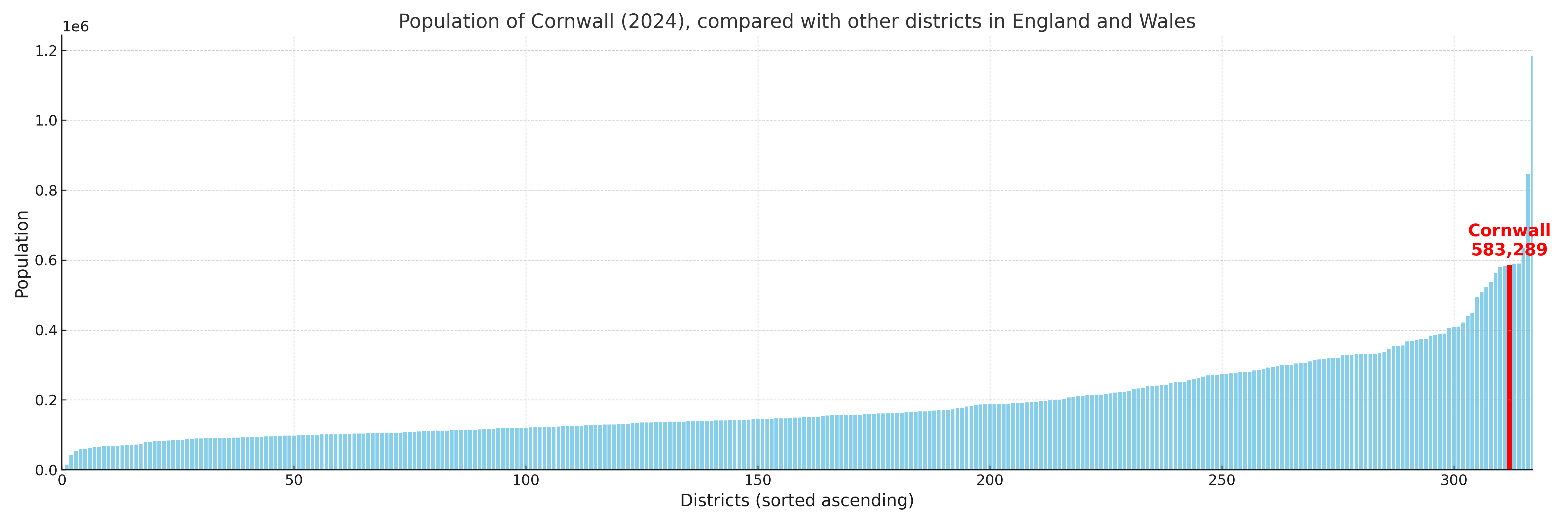
Cornwall compared with other districts in the UK
This section shows how Cornwall compares with other local authority districts in the UK, using a variety of measures and rankings.
Cornwall has 87 electoral wards.

Cornwall has a population of 583,289 (2024 mid-year estimate by ONS)
Population and Migration Trends in Cornwall
This chart shows the population trend for Cornwall from 2015 to 2024. It provides a quick overview of whether the local authority is growing, stable, or declining over time, and helps set context for the migration patterns shown below.
Population change is influenced by natural change (births minus deaths) and migration. The net migration chart below focuses on migration, separating internal migration (moves within the UK) from international migration (moves to and from abroad). Positive values indicate net inflows, while negative values indicate net outflows. The rate labels (per 1,000 residents) help compare migration intensity across years, even when the population size changes.
More local statistics and data for Cornwall can be found on the ONS statistics for Cornwall.
Latest news about Cornwall
Use the search box, or suggested search phrases, below to find recent news, council updates, planning stories, housing developments, transport changes, public services news, local elections, community issues and other local developments related to Cornwall. Results may include coverage from UK national, regional and local news websites, as well as official public-sector and local democracy sources.
- Cornwall council
- Cornwall planning
- Cornwall local elections
- Cornwall housing
- Cornwall transport
- Cornwall regeneration
- Cornwall public services