North Somerset
§ This page gives an overview of the North Somerset local authority district, bringing together key facts, maps, and data to help you quickly understand the area. This is one of 361 LAD profiles on Baseview.
Overview ⁞ North Somerset stretches along the Bristol Channel, combining seaside resorts, rural villages, and rolling countryside. Weston-super-Mare is the largest town, with its sandy beach, pier, and seafront attractions. Clevedon is known for its Victorian pier, while Portishead has a modern marina and coastal walks. The Mendip Hills provide scenic upland landscapes, while the Somerset Levels and rivers add to the district’s varied geography. Its coast, hills, and towns create a diverse environment.
North Somerset Boundary Map
This map shows the official boundary of the North Somerset local authority district, based on the latest geographic data published by the Office for National Statistics (ONS). It provides a clear view of the district’s extent and helps you understand how the area fits within the wider regional and national landscape.
Contains OS data © Crown copyright and database right 2025. Source: Office for National Statistics licensed under the Open Government Licence v3.0.
The administrative boundary of North Somerset can also be viewed on OpenStreetMap: District Boundary of North Somerset.
Key Facts about North Somerset
What region is North Somerset in? North Somerset is in the South West of England, a region within the UK.
What county is North Somerset in? North Somerset is in the county of Somerset.
Is North Somerset a city? No, North Somerset is not a city. (Note: the UK has 76 officially designated cities.)
Who governs North Somerset? The local government for this district is: North Somerset Council (Unitary Authority).
▶ Official website of North Somerset Council 🔗 n-somerset.gov.uk
Which police force covers North Somerset? Policing in North Somerset is provided by Avon and Somerset Constabulary 🔗 avonandsomerset.police.uk, which serves 5 local authority districts: Bath and North East Somerset ⁞ Bristol, City of ⁞ North Somerset ⁞ Somerset ⁞ South Gloucestershire.
North Somerset in International Geographies
In the International Territorial Levels (ITLs) hierarchy, North Somerset is within one of ITLs Level 2 area, North Somerset, Somerset and Dorset, that contains the following 4 ITLs Level 3 areas:
(ITL 1) South West
(ITL 2) ⇒ North Somerset, Somerset and Dorset
(ITL 3) ⇒⇒ North Somerset ⁞ Somerset ⁞ Bournemouth, Christchurch and Poole ⁞ Dorset
The International Territorial Levels are used by OECD member countries for statistical purposes to classify administrative areas. We have this listable page for easy browsing of ITL names and codes: International Territorial Levels.
Constituencies in North Somerset
North Somerset is divided into 3 parliamentary constituencies, listed below in alphabetical order.
A constituency is a specific geographical area that elects one Member of Parliament (MP) to represent them in the House of Commons. The United Kingdom is divided into 650 parliamentary constituencies. We have this list page for easy browsing of all UK parliamentary constituencies: List of Constituencies.
Wards in North Somerset
North Somerset is divided into 35 wards, listed below in alphabetical order.
- Backwell
- Banwell & Winscombe
- Blagdon & Churchill
- Clevedon East
- Clevedon South
- Clevedon Walton
- Clevedon West
- Clevedon Yeo
- Congresbury & Puxton
- Gordano Valley
- Hutton & Locking
- Long Ashton
- Nailsea Golden Valley
- Nailsea West End
- Nailsea Yeo
- Nailsea Youngwood
- Pill
- Portishead East
- Portishead North
- Portishead South
- Portishead West
- Weston-super-Mare Central
- Weston-super-Mare Hillside
- Weston-super-Mare Kewstoke
- Weston-super-Mare Mid Worle
- Weston-super-Mare Milton
- Weston-super-Mare North Worle
- Weston-super-Mare South
- Weston-super-Mare South Worle
- Weston-super-Mare Uphill
- Weston-super-Mare Winterstoke
- Wick St Lawrence & St Georges
- Winford
- Wrington
- Yatton
In the UK, a ward is a subdivision of a local authority area, used mainly for electoral and statistical purposes. Defined by the ONS, wards represent the primary unit for local elections, each returning one or more councillors to the local council. Wards are also used as a key geography for presenting population and census data. We have this list page for easy browsing of all electoral wards: List of all Electoral Wards in the UK.
Parishes in North Somerset
North Somerset is fully parished: 39 civil parishes, listed A-Z below.
- Abbots Leigh
- Backwell
- Banwell
- Barrow Gurney
- Blagdon
- Bleadon
- Brockley
- Burrington
- Butcombe
- Churchill
- Clapton-in-Gordano
- Cleeve
- Clevedon
- Congresbury
- Dundry
- Flax Bourton
- Hutton
- Kenn
- Kewstoke
- Kingston Seymour
- Locking
- Long Ashton
- Loxton
- Nailsea
- Pill and Easton-in-Gordano
- Portbury
- Portishead
- Puxton
- St. Georges
- Tickenham
- Walton-in-Gordano
- Weston-in-Gordano
- Weston-super-Mare
- Wick St. Lawrence
- Winford
- Winscombe and Sandford
- Wraxall and Failand
- Wrington
- Yatton
A civil parish is the lowest tier of local government in England, used for villages, small towns, and suburbs. They have their own local authority, either a parish council or a parish meeting, which provides local services like managing parks, allotments, and streetlights, and represents the community's views to larger councils.
We have this list page for easy browsing of all parishes: List of Civil Parishes in England and Wales.
Post Towns in North Somerset
Below is a list of post towns in North Somerset, grouped by postcode area:
- BS ▸ Banwell (BS29) ⁞ Clevedon (BS21) ⁞ Weston-super-Mare (BS22 / BS23 / BS24) ⁞ Winscombe (BS25)
The UK postal hierarchy begins with broad postcode areas (such as “CB” or “M”), which are divided into smaller postcode districts (such as “CB8” or “M1”) to support accurate mail routing. Each postal address is anchored by a designated post town, the official locality name used in the UK postcode system, which operates independently from Local Authority Districts —the administrative boundaries used for council tax and local government services. Because they serve different purposes, a property’s postal address and its local authority district do not always align exactly.
Built-up Areas in North Somerset
North Somerset covers 37 built-up areas, listed below in alphabetical order.
- Abbots Leigh
- Avonmouth *
- Backwell
- Banwell
- Barrow Gurney
- Blagdon
- Bleadon *
- Bristol *
- Cambridge Batch
- Churchill (North Somerset)
- Clapton in Gordano
- Cleeve
- Clevedon
- Congresbury
- Downside
- Dundry
- Failand
- Felton (North Somerset)
- Flax Bourton
- Hutton (North Somerset)
- Kewstoke
- Leigh Woods
- Locking
- Long Ashton
- Nailsea
- Pill *
- Portishead *
- Redhill (North Somerset)
- Stone-edge Batch
- Tickenham
- West Hill (North Somerset)
- West Wick
- Weston-super-Mare
- Winford (North Somerset)
- Winscombe and Sandford *
- Wrington
- Yatton
In the UK, a Built-up Area (BUA) is a continuous urban area of at least 20 hectares (0.2 km²), defined by the ONS as land where buildings are generally no more than 200 metres apart, such as towns, cities, or large villages. (Note: A BUA name marked with an asterisk (*) indicates that the area is situated partly in the district of North Somerset.)
We have this list page for easy browsing of all built-up areas: List of all Built-up Areas in GB.
Railway Stations in North Somerset
North Somerset is served by a number of National Rail stations, providing rail connections to nearby towns, cities, and destinations across Great Britain. The railway stations listed below are located within the North Somerset Local Authority District and are grouped by train operating company for clarity.
- Great Western Railway ▸ Weston-Super-Mare (BS23 1XY) ⁞ Yatton (BS49 4AJ) ⁞ Nailsea and Backwell (BS48 3LH) ⁞ Worle (BS22 6WA) ⁞ Weston Milton (BS22 8PF)
This is a district-level view only. For a complete list of all National Rail stations across Great Britain, see the UK National Rail Stations Directory.
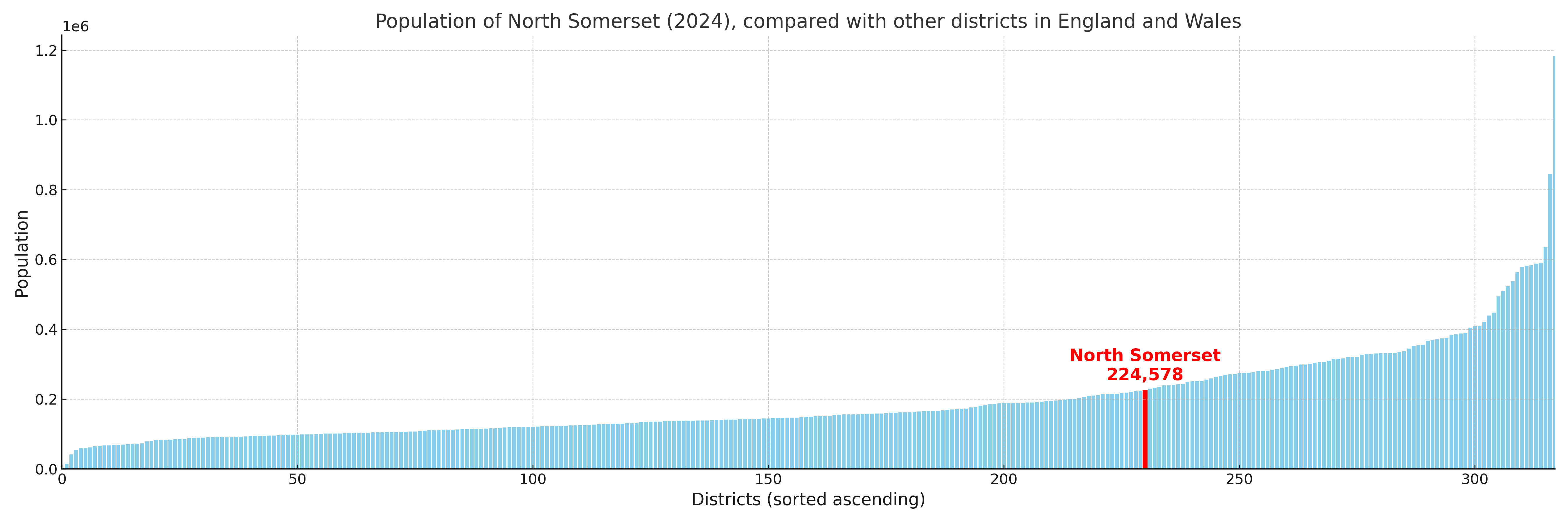
North Somerset compared with other districts in the UK
This section shows how North Somerset compares with other local authority districts in the UK, using a variety of measures and rankings.
North Somerset has 35 electoral wards.

North Somerset has a population of 224,578 (2024 mid-year estimate by ONS)
Population and Migration Trends in North Somerset
This chart shows the population trend for North Somerset from 2015 to 2024. It provides a quick overview of whether the local authority is growing, stable, or declining over time, and helps set context for the migration patterns shown below.
Population change is influenced by natural change (births minus deaths) and migration. The net migration chart below focuses on migration, separating internal migration (moves within the UK) from international migration (moves to and from abroad). Positive values indicate net inflows, while negative values indicate net outflows. The rate labels (per 1,000 residents) help compare migration intensity across years, even when the population size changes.
More local statistics and data for North Somerset can be found on the ONS statistics for North Somerset.
Latest news about North Somerset
Use the search box, or suggested search phrases, below to find recent news, council updates, planning stories, housing developments, transport changes, public services news, local elections, community issues and other local developments related to North Somerset. Results may include coverage from UK national, regional and local news websites, as well as official public-sector and local democracy sources.
- North Somerset council
- North Somerset planning
- North Somerset local elections
- North Somerset housing
- North Somerset transport
- North Somerset regeneration
- North Somerset public services