Dorset
§ This page gives an overview of the Dorset local authority district, bringing together key facts, maps, and data to help you quickly understand the area. This is one of 361 LAD profiles on Baseview.
Overview ⁞ Dorset is a county district famed for its Jurassic Coast, a UNESCO World Heritage Site with dramatic cliffs, coves, and fossil-rich beaches. Landmarks include Durdle Door, Lulworth Cove, and Chesil Beach, alongside seaside resorts like Weymouth and Lyme Regis. Inland, the landscape features rolling chalk hills, heathland, and the Blackmore Vale. Historic towns such as Dorchester, Sherborne, and Blandford Forum showcase heritage buildings and markets. The mix of coastline, countryside, and historic towns defines Dorset’s diverse geography.
Dorset Boundary Map
This map shows the official boundary of the Dorset local authority district, based on the latest geographic data published by the Office for National Statistics (ONS). It provides a clear view of the district’s extent and helps you understand how the area fits within the wider regional and national landscape.
Contains OS data © Crown copyright and database right 2025. Source: Office for National Statistics licensed under the Open Government Licence v3.0.
The administrative boundary of Dorset can also be viewed on OpenStreetMap: District Boundary of Dorset.
Key Facts about Dorset
What region is Dorset in? Dorset is in the South West of England, a region within the UK.
What county is Dorset in? Dorset is in the county of Dorset.
Is Dorset a city? No, Dorset is not a city. (Note: the UK has 76 officially designated cities.)
Who governs Dorset? The local government for this district is: Dorset Council (Unitary Authority).
▶ Official website of Dorset Council 🔗 dorsetcouncil.gov.uk
Which police force covers Dorset? Policing in Dorset is provided by Dorset Police 🔗 dorset.police.uk, which serves 2 local authority districts: Bournemouth, Christchurch and Poole ⁞ Dorset.
Dorset in International Geographies
In the International Territorial Levels (ITLs) hierarchy, Dorset is within one of ITLs Level 2 area, North Somerset, Somerset and Dorset, that contains the following 4 ITLs Level 3 areas:
(ITL 1) South West
(ITL 2) ⇒ North Somerset, Somerset and Dorset
(ITL 3) ⇒⇒ North Somerset ⁞ Somerset ⁞ Bournemouth, Christchurch and Poole ⁞ Dorset
The International Territorial Levels are used by OECD member countries for statistical purposes to classify administrative areas. We have this listable page for easy browsing of ITL names and codes: International Territorial Levels.
Constituencies in Dorset
Dorset is divided into 5 parliamentary constituencies, listed below in alphabetical order.
A constituency is a specific geographical area that elects one Member of Parliament (MP) to represent them in the House of Commons. The United Kingdom is divided into 650 parliamentary constituencies. We have this list page for easy browsing of all UK parliamentary constituencies: List of Constituencies.
Wards in Dorset
Dorset is divided into 52 wards, listed below in alphabetical order.
- Beacon
- Beaminster
- Blackmore Vale
- Blandford
- Bridport
- Chalk Valleys
- Charminster St Mary's
- Chesil Bank
- Chickerell
- Colehill & Wimborne Minster East
- Corfe Mullen
- Cranborne & Alderholt
- Cranborne Chase
- Crossways
- Dorchester East
- Dorchester Poundbury
- Dorchester West
- Eggardon
- Ferndown North
- Ferndown South
- Gillingham
- Hill Forts & Upper Tarrants
- Littlemoor & Preston
- Lyme & Charmouth
- Lytchett Matravers & Upton
- Marshwood Vale
- Melcombe Regis
- Portland
- Puddletown & Lower Winterborne
- Radipole
- Rodwell & Wyke
- Shaftesbury Town
- Sherborne East
- Sherborne Rural
- Sherborne West
- South East Purbeck
- St Leonards & St Ives
- Stalbridge & Marnhull
- Stour & Allen Vale
- Sturminster Newton
- Swanage
- Upwey & Broadwey
- Verwood
- Wareham
- West Moors & Three Legged Cross
- West Parley
- West Purbeck
- Westham
- Wimborne Minster
- Winterborne & Broadmayne
- Winterborne North
- Yetminster
In the UK, a ward is a subdivision of a local authority area, used mainly for electoral and statistical purposes. Defined by the ONS, wards represent the primary unit for local elections, each returning one or more councillors to the local council. Wards are also used as a key geography for presenting population and census data. We have this list page for easy browsing of all electoral wards: List of all Electoral Wards in the UK.
Parishes in Dorset
Dorset is fully parished: 259 civil parishes, listed A-Z below.
- Abbotsbury
- Affpuddle and Turnerspuddle
- Alderholt
- Alton Pancras
- Anderson
- Arne
- Ashmore
- Askerswell
- Athelhampton and Puddletown
- Batcombe
- Beaminster
- Beer Hackett
- Bere Regis
- Bettiscombe
- Bincombe
- Bishop's Caundle
- Blandford Forum
- Blandford St. Mary
- Bloxworth
- Bourton
- Bradford Abbas
- Bradford Peverell
- Bridport
- Broadmayne
- Broadwindsor
- Bryanston
- Buckhorn Weston
- Buckland Newton
- Burleston and Tolpuddle
- Burstock
- Burton Bradstock
- Cann
- Castleton
- Catherston Leweston
- Cattistock
- Caundle Marsh
- Cerne Abbas
- Chalbury
- Chaldon Herring
- Charlton Marshall
- Charminster
- Charmouth
- Chedington
- Cheselbourne
- Chetnole
- Chettle
- Chickerell
- Chideock
- Chilcombe
- Child Okeford
- Chilfrome
- Church Knowle
- Clifton Maybank
- Colehill
- Compton Abbas
- Compton Valence
- Coombe Keynes
- Corfe Castle
- Corfe Mullen
- Corscombe
- Cranborne
- Crichel
- Crossways
- Dewlish
- Dorchester
- Durweston
- East Chelborough
- East Holme
- East Lulworth
- East Orchard
- East Stoke
- East Stour
- Edmondsham
- Evershot
- Farnham
- Ferndown Town
- Fifehead Magdalen
- Fifehead Neville
- Fleet
- Folke
- Fontmell Magna
- Frampton
- Frome St. Quintin
- Frome Vauchurch
- Gillingham
- Glanvilles Wootton
- Goathill
- Godmanstone
- Gussage All Saints
- Gussage St. Michael
- Halstock
- Hammoon
- Hanford
- Haydon
- Hazelbury Bryan
- Hermitage
- Hilfield
- Hilton
- Hinton
- Hinton St. Mary
- Holnest
- Holt
- Holwell
- Hooke
- Horton
- Ibberton
- Iwerne Courtney or Shroton
- Iwerne Minster
- Iwerne Stepleton
- Kimmeridge
- Kington Magna
- Langton Herring
- Langton Long Blandford
- Langton Matravers
- Leigh
- Leweston
- Lillington
- Littlebredy
- Litton Cheney
- Loders
- Long Bredy and Kingston Russell
- Longburton
- Lydlinch
- Lyme Regis
- Lytchett Matravers
- Lytchett Minster and Upton
- Maiden Newton
- Manston
- Mapperton
- Mappowder
- Margaret Marsh
- Marnhull
- Marshwood
- Melbury Abbas
- Melbury Bubb
- Melbury Osmond
- Melbury Sampford
- Melcombe Horsey
- Milborne St. Andrew
- Milton Abbas
- Minterne Magna
- Morden
- Moreton
- Mosterton
- Motcombe
- Nether Cerne
- Nether Compton
- Netherbury
- North Poorton
- North Wootton
- Oborne
- Okeford Fitzpaine
- Osmington
- Over Compton
- Owermoigne
- Pamphill
- Piddlehinton
- Piddletrenthide
- Pilsdon
- Pimperne
- Portesham
- Portland
- Powerstock
- Poxwell
- Poyntington
- Pulham
- Puncknowle
- Purse Caundle
- Rampisham
- Ryme Intrinseca
- Sandford Orcas
- Seaborough
- Shaftesbury
- Shapwick
- Sherborne
- Shillingstone
- Shipton Gorge
- Silton
- Sixpenny Handley and Pentridge
- South Perrott
- Spetisbury
- St. Leonards and St. Ives
- Stalbridge
- Stanton St. Gabriel
- Steeple with Tyneham
- Stinsford
- Stockwood
- Stoke Abbott
- Stoke Wake
- Stour Provost
- Stourpaine
- Stourton Caundle
- Stratton
- Studland
- Sturminster Marshall
- Sturminster Newton
- Sutton Waldron
- Swanage
- Swyre
- Sydling St. Nicholas
- Symondsbury
- Tarrant Crawford
- Tarrant Gunville
- Tarrant Hinton
- Tarrant Keyneston
- Tarrant Launceston
- Tarrant Monkton
- Tarrant Rawston
- Tarrant Rushton
- Thorncombe
- Thornford
- Tincleton
- Todber
- Toller Fratrum
- Toller Porcorum
- Trent
- Turnworth
- Up Cerne
- Verwood
- Wareham St. Martin
- Wareham Town
- Warmwell
- West Chelborough
- West Compton
- West Knighton
- West Lulworth
- West Moors
- West Orchard
- West Parley
- West Stafford
- West Stour
- Weymouth
- Whitchurch Canonicorum
- Whitcombe
- Wimborne Minster
- Wimborne St. Giles
- Winfrith Newburgh
- Winterborne Came
- Winterborne Clenston
- Winterborne Herringston
- Winterborne Houghton
- Winterborne Kingston
- Winterborne Monkton
- Winterborne St. Martin
- Winterborne Stickland
- Winterborne Whitechurch
- Winterborne Zelston
- Winterbourne Abbas
- Winterbourne Steepleton
- Witchampton
- Woodlands
- Woodsford
- Wool
- Woolland
- Wootton Fitzpaine
- Worth Matravers
- Wraxall
- Wynford Eagle
- Yetminster
A civil parish is the lowest tier of local government in England, used for villages, small towns, and suburbs. They have their own local authority, either a parish council or a parish meeting, which provides local services like managing parks, allotments, and streetlights, and represents the community's views to larger councils.
We have this list page for easy browsing of all parishes: List of Civil Parishes in England and Wales.
Post Towns in Dorset
Below is a list of post towns in Dorset, grouped by postcode area:
- BH ▸ Ferndown (BH22) ⁞ Swanage (BH19) ⁞ Verwood (BH31) ⁞ Wareham (BH20) ⁞ Wimborne (BH21)
- DT ▸ Beaminster (DT8) ⁞ Blandford Forum (DT11) ⁞ Bridport (DT6) ⁞ Dorchester (DT1 / DT2) ⁞ Lyme Regis (DT7) ⁞ Portland (DT5) ⁞ Sherborne (DT9) ⁞ Sturminster Newton (DT10) ⁞ Weymouth (DT3 / DT4)
- SP ▸ Gillingham (SP8) ⁞ Shaftesbury (SP7)
The UK postal hierarchy begins with broad postcode areas (such as “CB” or “M”), which are divided into smaller postcode districts (such as “CB8” or “M1”) to support accurate mail routing. Each postal address is anchored by a designated post town, the official locality name used in the UK postcode system, which operates independently from Local Authority Districts —the administrative boundaries used for council tax and local government services. Because they serve different purposes, a property’s postal address and its local authority district do not always align exactly.
Built-up Areas in Dorset
Dorset covers 141 built-up areas, listed below in alphabetical order.
- Abbotsbury
- Alderholt *
- Ash (Dorset)
- Ashley Heath *
- Ashmore
- Barwick and Stoford *
- Batcombe (Dorset)
- Beacon Hill
- Beaminster
- Bere Regis
- Bishop's Caundle
- Blandford Forum
- Bournemouth *
- Bourton (Dorset) *
- Bradford Abbas
- Bradpole
- Briantspuddle
- Bridport
- Broadmayne
- Broadwindsor
- Broom Hill
- Bryanston
- Buckhorn Weston
- Burngate
- Burton Bradstock
- Cerne Abbas
- Chalbury Common
- Charlton Down
- Charlton Marshall
- Charminster
- Charmouth
- Cheselbourne
- Chetnole
- Chickerell
- Chideock
- Child Okeford
- Corfe Castle
- Corfe Mullen *
- Corscombe
- Cranborne
- Crossways
- Dorchester (Dorset)
- Durweston
- East Stour
- Ferndown
- Fontmell Magna
- Fortuneswell
- Furzehill
- Gaunt's Common
- Gillingham (Dorset)
- Grove (Dorset)
- Harman's Cross
- Hazelbury Bryan
- Henstridge Marsh *
- Holt (Dorset)
- Holton Heath
- Holwell (Dorset)
- Iwerne Minster
- Kington Magna
- Langton Matravers
- Leigh (Dorset)
- Leweston
- Litton Cheney
- Loders
- Longburton
- Longham
- Lyme Regis *
- Lytchett Matravers
- Maiden Newton
- Marnhull
- Matchams
- Merley *
- Milborne St Andrew
- Milton on Stour
- Morcombelake
- Mosterton
- Motcombe
- Nether Compton
- Netherbury
- Okeford Fitzpaine
- Osmington
- Owermoigne
- Piddlehinton
- Piddletrenthide
- Pimperne
- Poole *
- Portesham
- Post Green
- Puddletown
- Raymond's Hill *
- Ridge
- Sandford (Dorset)
- Shaftesbury *
- Sherborne
- Shillingstone
- Shroton
- Sixpenny Handley
- Southwell (Dorset)
- Spetisbury
- Stalbridge
- Stinsford, Lower Bockhampton and Kingston Maurward
- Stoborough
- Stone (Dorset)
- Stour Row
- Stourpaine
- Stourton Caundle
- Studland
- Sturminster Marshall
- Sturminster Newton
- Swanage
- Sydling St Nicholas
- Tarrant Monkton
- Tatworth *
- Thornford
- Three Legged Cross
- Tolpuddle
- Trent
- Uplyme *
- Upton (Dorset) *
- Verwood *
- Wareham
- West Knighton
- West Lulworth
- West Moors
- West Parley
- West Stour
- Weston (Dorset)
- Weymouth
- Whitchurch Canonicorum
- Whitmore
- Wimborne Minster
- Winfrith Newburgh
- Winterborne Kingston
- Winterborne St Martin
- Winterborne Stickland
- Winterborne Whitechurch
- Wool
- Worth Matravers
- Yeovil *
- Yetminster
- Zeals *
In the UK, a Built-up Area (BUA) is a continuous urban area of at least 20 hectares (0.2 km²), defined by the ONS as land where buildings are generally no more than 200 metres apart, such as towns, cities, or large villages. (Note: A BUA name marked with an asterisk (*) indicates that the area is situated partly in the district of Dorset.)
We have this list page for easy browsing of all built-up areas: List of all Built-up Areas in GB.
Railway Stations in Dorset
Dorset is served by a number of National Rail stations, providing rail connections to nearby towns, cities, and destinations across Great Britain. The railway stations listed below are located within the Dorset Local Authority District and are grouped by train operating company for clarity.
- Great Western Railway ▸ Dorchester West (DT1 2LB) ⁞ Maiden Newton (DT2 0AE) ⁞ Yetminster (DT9 6LH) ⁞ Chetnole (DT9 6EP) ⁞ Thornford (DT9 6PT)
- South Western Railway ▸ Weymouth (DT4 7BN) ⁞ Dorchester South (DT1 1QX) ⁞ Gillingham (Dorset) (SP8 4PZ) ⁞ Wareham (Dorset) (BH20 4AS) ⁞ Wool (BH20 6BL) ⁞ Sherborne (DT9 3NB) ⁞ Moreton (Dorset) (DT2 8BB) ⁞ Upwey (DT3 5RB) ⁞ Holton Heath (BH16 6JT)
- Swanage Railway ▸ Corfe Castle (BH20 5EJ)
This is a district-level view only. For a complete list of all National Rail stations across Great Britain, see the UK National Rail Stations Directory.
Dorset compared with other districts in the UK
This section shows how Dorset compares with other local authority districts in the UK, using a variety of measures and rankings.
Dorset has 52 electoral wards.

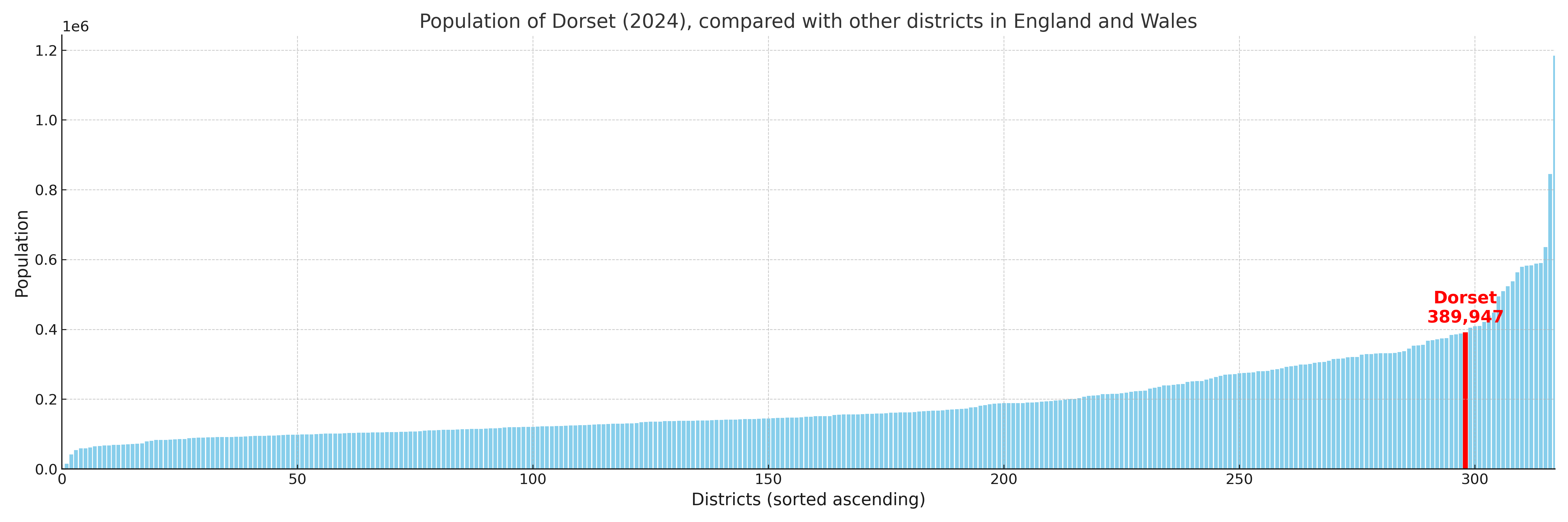
Dorset has a population of 389,947 (2024 mid-year estimate by ONS)
Population and Migration Trends in Dorset
This chart shows the population trend for Dorset from 2015 to 2024. It provides a quick overview of whether the local authority is growing, stable, or declining over time, and helps set context for the migration patterns shown below.
Population change is influenced by natural change (births minus deaths) and migration. The net migration chart below focuses on migration, separating internal migration (moves within the UK) from international migration (moves to and from abroad). Positive values indicate net inflows, while negative values indicate net outflows. The rate labels (per 1,000 residents) help compare migration intensity across years, even when the population size changes.
More local statistics and data for Dorset can be found on the ONS statistics for Dorset.
Latest news about Dorset
Use the search box, or suggested search phrases, below to find recent news, council updates, planning stories, housing developments, transport changes, public services news, local elections, community issues and other local developments related to Dorset. Results may include coverage from UK national, regional and local news websites, as well as official public-sector and local democracy sources.
- Dorset council
- Dorset planning
- Dorset local elections
- Dorset housing
- Dorset transport
- Dorset regeneration
- Dorset public services