Wiltshire
§ This page gives an overview of the Wiltshire local authority district, bringing together key facts, maps, and data to help you quickly understand the area. This is one of 361 LAD profiles on Baseview.
Overview ⁞ Wiltshire is a landlocked county in central South West England, famous for Stonehenge, Salisbury Cathedral, and its military connections, particularly on Salisbury Plain. The county is primarily rural with market towns like Chippenham, Trowbridge (the administrative centre), and Devizes. It is governed by two unitary authorities: Wiltshire Council and Swindon Borough Council, which operates independently but remains within the ceremonial boundary.
Wiltshire Boundary Map
This map shows the official boundary of the Wiltshire local authority district, based on the latest geographic data published by the Office for National Statistics (ONS). It provides a clear view of the district’s extent and helps you understand how the area fits within the wider regional and national landscape.
Contains OS data © Crown copyright and database right 2025. Source: Office for National Statistics licensed under the Open Government Licence v3.0.
The administrative boundary of Wiltshire can also be viewed on OpenStreetMap: District Boundary of Wiltshire.
Key Facts about Wiltshire
What region is Wiltshire in? Wiltshire is in the South West of England, a region within the UK.
What county is Wiltshire in? Wiltshire is in the county of Wiltshire.
Is Wiltshire a city? Yes, Wiltshire is a city. Wiltshire holds official city status as one of the 76 designated cities in the UK.
Who governs Wiltshire? The local government for this district is: Wiltshire Council (Unitary Authority).
▶ Official website of Wiltshire Council 🔗 wiltshire.gov.uk
Which police force covers Wiltshire? Policing in Wiltshire is provided by Wiltshire Police 🔗 wiltshire.police.uk, which serves 2 local authority districts: Swindon ⁞ Wiltshire.
Wiltshire in International Geographies
In the International Territorial Levels (ITLs) hierarchy, Wiltshire is within one of ITLs Level 2 area, Gloucestershire and Wiltshire, that contains the following 3 ITLs Level 3 areas:
(ITL 1) South West
(ITL 2) ⇒ Gloucestershire and Wiltshire
(ITL 3) ⇒⇒ Swindon ⁞ Wiltshire ⁞ Gloucestershire CC
The International Territorial Levels are used by OECD member countries for statistical purposes to classify administrative areas. We have this listable page for easy browsing of ITL names and codes: International Territorial Levels.
Constituencies in Wiltshire
Wiltshire is divided into 6 parliamentary constituencies, listed below in alphabetical order.
A constituency is a specific geographical area that elects one Member of Parliament (MP) to represent them in the House of Commons. The United Kingdom is divided into 650 parliamentary constituencies. We have this list page for easy browsing of all UK parliamentary constituencies: List of Constituencies.
Wards in Wiltshire
Wiltshire is divided into 98 wards, listed below in alphabetical order.
- Aldbourne & Ramsbury
- Alderbury & Whiteparish
- Amesbury East & Bulford
- Amesbury South
- Amesbury West
- Avon Valley
- Bowerhill
- Box & Colerne
- Bradford-on-Avon North
- Bradford-on-Avon South
- Brinkworth
- Bromham, Rowde & Roundway
- By Brook
- Calne Central
- Calne Chilvester & Abberd
- Calne North
- Calne Rural
- Calne South
- Chippenham Cepen Park & Derriads
- Chippenham Cepen Park & Hunters Moon
- Chippenham Hardenhuish
- Chippenham Hardens & Central
- Chippenham Lowden & Rowden
- Chippenham Monkton
- Chippenham Pewsham
- Chippenham Sheldon
- Corsham Ladbrook
- Corsham Pickwick
- Corsham Without
- Cricklade & Latton
- Devizes East
- Devizes North
- Devizes Rural West
- Devizes South
- Downton & Ebble Valley
- Durrington
- Ethandune
- Fovant & Chalke Valley
- Hilperton
- Holt
- Kington
- Laverstock
- Ludgershall North & Rural
- Lyneham
- Malmesbury
- Marlborough East
- Marlborough West
- Melksham East
- Melksham Forest
- Melksham South
- Melksham Without North & Shurnhold
- Melksham Without West & Rural
- Mere
- Minety
- Nadder Valley
- Old Sarum & Lower Bourne Valley
- Pewsey
- Pewsey Vale East
- Pewsey Vale West
- Purton
- Redlynch & Landford
- Royal Wootton Bassett East
- Royal Wootton Bassett North
- Royal Wootton Bassett South & West
- Salisbury Bemerton Heath
- Salisbury Fisherton & Bemerton Village
- Salisbury Harnham East
- Salisbury Harnham West
- Salisbury Milford
- Salisbury St Edmund's
- Salisbury St Francis & Stratford
- Salisbury St Paul's
- Sherston
- Southwick
- The Lavingtons
- Tidworth East & Ludgershall South
- Tidworth North & West
- Till Valley
- Tisbury
- Trowbridge Adcroft
- Trowbridge Central
- Trowbridge Drynham
- Trowbridge Grove
- Trowbridge Lambrok
- Trowbridge Park
- Trowbridge Paxcroft
- Urchfont & Bishops Cannings
- Warminster Broadway
- Warminster East
- Warminster North & Rural
- Warminster West
- Westbury East
- Westbury North
- Westbury West
- Wilton
- Winsley & Westwood
- Winterslow & Upper Bourne Valley
- Wylye Valley
In the UK, a ward is a subdivision of a local authority area, used mainly for electoral and statistical purposes. Defined by the ONS, wards represent the primary unit for local elections, each returning one or more councillors to the local council. Wards are also used as a key geography for presenting population and census data. We have this list page for easy browsing of all electoral wards: List of all Electoral Wards in the UK.
Parishes in Wiltshire
Wiltshire is fully parished: 258 civil parishes, listed A-Z below.
- Aldbourne
- Alderbury
- All Cannings
- Allington
- Alton
- Alvediston
- Amesbury
- Ansty
- Ashton Keynes
- Atworth
- Avebury
- Barford St. Martin
- Baydon
- Beechingstoke
- Berwick Bassett
- Berwick St. James
- Berwick St. John
- Berwick St. Leonard
- Biddestone and Slaughterford
- Bishops Cannings
- Bishopstone
- Bishopstrow
- Bowerchalke
- Box
- Boyton
- Bradford-on-Avon
- Bratton
- Braydon
- Bremhill
- Brinkworth
- Britford
- Brixton Deverill
- Broad Chalke
- Broad Hinton
- Broad Town
- Brokenborough
- Bromham
- Broughton Gifford
- Bulford
- Bulkington
- Burbage
- Burcombe Without
- Buttermere
- Calne
- Calne Without
- Castle Combe
- Chapmanslade
- Charlton
- Charlton St Peter
- Cherhill
- Cheverell Magna
- Chicklade
- Chilmark
- Chilton Foliat
- Chippenham
- Chippenham Without
- Chirton
- Chitterne
- Cholderton
- Christian Malford
- Chute
- Chute Forest
- Clarendon Park
- Clyffe Pypard
- Codford
- Colerne
- Collingbourne Ducis
- Collingbourne Kingston
- Compton Bassett
- Compton Chamberlayne
- Coombe Bissett
- Corsham
- Corsley
- Coulston
- Cricklade
- Crudwell
- Dauntsey
- Devizes
- Dilton Marsh
- Dinton
- Donhead St. Andrew
- Donhead St. Mary
- Downton
- Durnford
- Durrington
- East Kennett
- East Knoyle
- Easterton
- Easton
- Easton Grey
- Ebbesborne Wake
- Edington
- Enford
- Erlestoke
- Etchilhampton
- Everleigh
- Figheldean
- Firsdown
- Fittleton cum Haxton
- Fonthill Bishop
- Fonthill Gifford
- Fovant
- Froxfield
- Fyfield
- Grafton
- Great Bedwyn
- Great Hinton
- Great Somerford
- Great Wishford
- Grimstead
- Grittleton
- Ham
- Hankerton
- Heddington
- Heytesbury
- Heywood
- Hilmarton
- Hilperton
- Hindon
- Holt
- Horningsham
- Hullavington
- Idmiston
- Keevil
- Kilmington
- Kingston Deverill
- Kington Langley
- Kington St. Michael
- Knook
- Lacock
- Landford
- Langley Burrell Without
- Latton
- Laverstock
- Lea and Cleverton
- Leigh
- Limpley Stoke
- Little Bedwyn
- Little Cheverell
- Little Somerford
- Longbridge Deverill
- Luckington
- Ludgershall
- Lydiard Millicent
- Lydiard Tregoze
- Lyneham and Bradenstoke
- Maiden Bradley with Yarnfield
- Malmesbury
- Manningford
- Marden
- Market Lavington
- Marlborough
- Marston
- Marston Maisey
- Melksham
- Melksham Without
- Mere
- Mildenhall
- Milston
- Milton Lilbourne
- Minety
- Monkton Farleigh
- Netheravon
- Netherhampton
- Nettleton
- Newton Tony
- North Bradley
- North Newnton
- North Wraxall
- Norton
- Norton Bavant
- Oaksey
- Odstock
- Ogbourne St. Andrew
- Ogbourne St. George
- Orcheston
- Patney
- Pewsey
- Pitton and Farley
- Potterne
- Poulshot
- Preshute
- Purton
- Quidhampton
- Ramsbury
- Redlynch
- Rowde
- Royal Wootton Bassett
- Rushall
- Salisbury
- Savernake
- Seagry
- Sedgehill and Semley
- Seend
- Semington
- Shalbourne
- Sherrington
- Sherston
- Shrewton
- Sopworth
- South Newton
- South Wraxall
- Southwick
- St. Paul Malmesbury Without
- Stanton St. Bernard
- Stanton St. Quintin
- Stapleford
- Staverton
- Steeple Ashton
- Steeple Langford
- Stert
- Stockton
- Stourton with Gasper
- Stratford Toney
- Sutton Benger
- Sutton Mandeville
- Sutton Veny
- Swallowcliffe
- Teffont
- Tidcombe and Fosbury
- Tidworth
- Tilshead
- Tisbury
- Tockenham
- Tollard Royal
- Trowbridge
- Upavon
- Upton Lovell
- Upton Scudamore
- Urchfont
- Warminster
- West Ashton
- West Dean
- West Knoyle
- West Lavington
- West Overton
- West Tisbury
- Westbury
- Westwood
- Whiteparish
- Wilcot, Huish and Oare
- Wilsford
- Wilsford cum Lake
- Wilton
- Wingfield
- Winsley
- Winterbourne
- Winterbourne Bassett
- Winterbourne Monkton
- Winterbourne Stoke
- Winterslow
- Woodborough
- Woodford
- Wootton Rivers
- Worton
- Wylye
- Yatton Keynell
- Zeals
A civil parish is the lowest tier of local government in England, used for villages, small towns, and suburbs. They have their own local authority, either a parish council or a parish meeting, which provides local services like managing parks, allotments, and streetlights, and represents the community's views to larger councils.
We have this list page for easy browsing of all parishes: List of Civil Parishes in England and Wales.
Post Towns in Wiltshire
Below is a list of post towns in Wiltshire, grouped by postcode area:
- BA ▸ Bradford-on-Avon (BA15) ⁞ Trowbridge (BA14) ⁞ Warminster (BA12) ⁞ Westbury (BA13)
- SN ▸ Calne (SN11) ⁞ Chippenham (SN14 / SN15) ⁞ Corsham (SN13 / SN15) ⁞ Devizes (SN10) ⁞ Malmesbury (SN16) ⁞ Marlborough (SN8) ⁞ Melksham (SN12) ⁞ Pewsey (SN9)
- SP ▸ Salisbury (SP1 / SP2 / SP3 / SP4 / SP5) ⁞ Tidworth (SP9)
The UK postal hierarchy begins with broad postcode areas (such as “CB” or “M”), which are divided into smaller postcode districts (such as “CB8” or “M1”) to support accurate mail routing. Each postal address is anchored by a designated post town, the official locality name used in the UK postcode system, which operates independently from Local Authority Districts —the administrative boundaries used for council tax and local government services. Because they serve different purposes, a property’s postal address and its local authority district do not always align exactly.
Built-up Areas in Wiltshire
Wiltshire covers 178 built-up areas, listed below in alphabetical order.
- Aldbourne
- All Cannings
- Amesbury
- Ashton Keynes
- Atworth
- Baydon
- Beanacre
- Berryfield
- Berwick St John
- Biddestone
- Bowerchalke
- Bowerhill
- Box (Wiltshire)
- Bradford-on-Avon
- Bratton
- Brinkworth
- Britford
- Broad Chalke
- Broad Hinton
- Broad Town
- Bromham (Wiltshire)
- Broughton Gifford
- Bulford
- Burbage
- Calne
- Chapmanslade *
- Chelworth Lower Green
- Cherhill
- Chilmark
- Chippenham (Wiltshire)
- Chirton
- Chitterne
- Christian Malford
- Clanville
- Codford St Peter
- Colerne
- Collingbourne Ducis
- Collingbourne Kingston
- Coombe Bissett
- Corsham
- Corston (Wiltshire)
- Cricklade
- Crockerton
- Croucheston
- Crudwell
- Derry Hill and Studley
- Devizes
- Dilton Marsh
- Dinton (Wiltshire)
- Donhead St Mary
- Down Ampney *
- Downton
- Dunfield *
- Durrington
- East Grafton
- East Grimstead
- East Knoyle
- Easterton
- Easton Royal
- Edington
- Erlestoke
- Firsdown
- Fovant
- Gastard
- Gomeldon
- Great Bedwyn
- Great Cheverell
- Great Somerford
- Ham
- Heytesbury
- Higher Coombe
- Hindon
- Holt (Wiltshire)
- Hullavington
- Idmiston
- Keevil
- Kington Langley
- Kington St Michael
- Lackham
- Landford and Nomansland *
- Larkhill
- Latton
- Lea (Wiltshire)
- Leigh Delamere
- Limpley Stoke *
- Littleton Panell
- Lover
- Lower Stanton St Quintin
- Lower Wraxall
- Luckington
- Ludgershall (Wiltshire) *
- Lydiard Millicent
- Lye's Green *
- Lyneham
- Maiden Bradley
- Malmesbury
- Manton (Wiltshire)
- Market Lavington
- Marlborough
- Melksham
- Mere (Wiltshire)
- Middle Winterslow
- Mildenhall (Wiltshire)
- Milton Lilbourne
- Minety
- Monkton Combe *
- Neston (Wiltshire)
- Netheravon
- Newton Tony
- North Bradley
- Notton (Wiltshire)
- Nunton
- Oaksey
- Oare
- Ogbourne Maizey
- Ogbourne St George
- Old Sarum
- Perham Down
- Pewsey
- Pitton
- Plaitford *
- Porton
- Potterne
- Poulshot
- Purton
- Ramsbury
- Redlynch and Woodfalls *
- Rodmarton *
- Rowde
- Royal Wootton Bassett
- Rudloe
- Salisbury
- Seend
- Seend Cleeve
- Semington
- Shaftesbury *
- Shalbourne
- Shaw (Wiltshire)
- Sherston
- Shrewton
- South Cerney *
- South Newton
- Southwick (Wiltshire)
- Steeple Ashton
- Sutton Benger
- Sutton Veny
- Swindon (Swindon) *
- Teffont Evias
- Tidworth
- Tilshead
- Tisbury
- Trowbridge
- Upavon
- Upper Castle Combe
- Upper Minety
- Upper Seagry
- Urchfont
- Warminster
- West Ashton
- West Dean (Test Valley) *
- West Grimstead
- West Kington
- Westbury (Wiltshire)
- Westonbirt *
- Westwood
- Whaddon (Wiltshire)
- Whiteparish
- Whitley (Wiltshire)
- Wilton
- Winsley
- Winterbourne Dauntsey and Winterbourne Earls
- Winterbourne Gunner
- Woodborough (Wiltshire)
- Wootton Rivers
- Worton
- Wylye
- Yatton Keynell
- Zeals *
In the UK, a Built-up Area (BUA) is a continuous urban area of at least 20 hectares (0.2 km²), defined by the ONS as land where buildings are generally no more than 200 metres apart, such as towns, cities, or large villages. (Note: A BUA name marked with an asterisk (*) indicates that the area is situated partly in the district of Wiltshire.)
We have this list page for easy browsing of all built-up areas: List of all Built-up Areas in GB.
Railway Stations in Wiltshire
Wiltshire is served by a number of National Rail stations, providing rail connections to nearby towns, cities, and destinations across Great Britain. The railway stations listed below are located within the Wiltshire Local Authority District and are grouped by train operating company for clarity.
- Great Western Railway ▸ Chippenham (SN15 3QE) ⁞ Trowbridge (BA14 8HW) ⁞ Westbury (BA13 4HP) ⁞ Bradford-On-Avon (BA15 1DF) ⁞ Warminster (BA12 9BP) ⁞ Pewsey (SN9 5ER) ⁞ Bedwyn (SN8 5RD) ⁞ Melksham (SN12 8BN) ⁞ Dean (Wilts) (SP5 1JF) ⁞ Avoncliff (BA15 2HD) ⁞ Dilton Marsh (BA13 4DF)
- South Western Railway ▸ Salisbury (SP2 7RS) ⁞ Tisbury (SP3 6JT)
This is a district-level view only. For a complete list of all National Rail stations across Great Britain, see the UK National Rail Stations Directory.
Wiltshire compared with other districts in the UK
This section shows how Wiltshire compares with other local authority districts in the UK, using a variety of measures and rankings.
Wiltshire has 98 electoral wards.

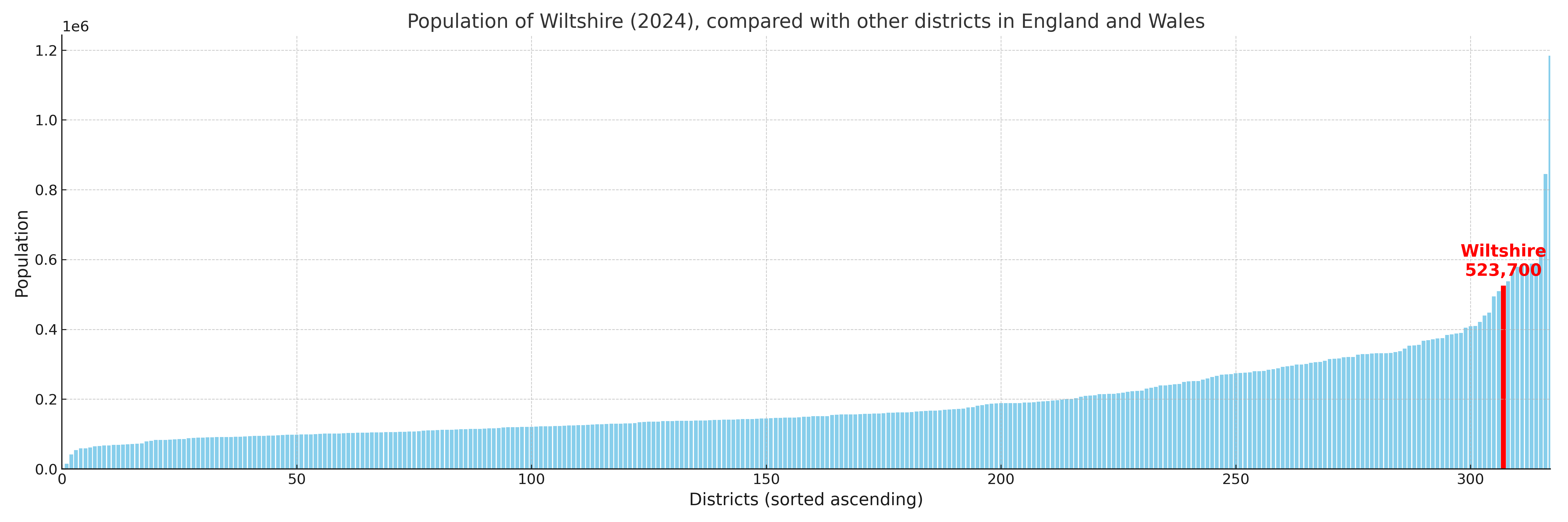
Wiltshire has a population of 523,700 (2024 mid-year estimate by ONS)
Population and Migration Trends in Wiltshire
This chart shows the population trend for Wiltshire from 2015 to 2024. It provides a quick overview of whether the local authority is growing, stable, or declining over time, and helps set context for the migration patterns shown below.
Population change is influenced by natural change (births minus deaths) and migration. The net migration chart below focuses on migration, separating internal migration (moves within the UK) from international migration (moves to and from abroad). Positive values indicate net inflows, while negative values indicate net outflows. The rate labels (per 1,000 residents) help compare migration intensity across years, even when the population size changes.
More local statistics and data for Wiltshire can be found on the ONS statistics for Wiltshire.
Latest news about Wiltshire
Use the search box, or suggested search phrases, below to find recent news, council updates, planning stories, housing developments, transport changes, public services news, local elections, community issues and other local developments related to Wiltshire. Results may include coverage from UK national, regional and local news websites, as well as official public-sector and local democracy sources.
- Wiltshire council
- Wiltshire planning
- Wiltshire local elections
- Wiltshire housing
- Wiltshire transport
- Wiltshire regeneration
- Wiltshire public services