Bournemouth, Christchurch and Poole
§ This page gives an overview of the Bournemouth, Christchurch and Poole local authority district, bringing together key facts, maps, and data to help you quickly understand the area. This is one of 361 LAD profiles on Baseview.
Overview ⁞ Bournemouth, Christchurch and Poole form a large coastal district on the south coast of Dorset. Bournemouth is a major resort with sandy beaches, gardens, and a lively pier, while Poole is famous for its natural harbour, Brownsea Island, and maritime activities. Christchurch adds historic charm with its priory and riverside setting. The coastline features cliffs, bays, and nature reserves, while the New Forest lies nearby. This combined district balances urban vibrancy with seaside and natural landscapes.
Bournemouth, Christchurch and Poole Boundary Map
This map shows the official boundary of the Bournemouth, Christchurch and Poole local authority district, based on the latest geographic data published by the Office for National Statistics (ONS). It provides a clear view of the district’s extent and helps you understand how the area fits within the wider regional and national landscape.
Contains OS data © Crown copyright and database right 2025. Source: Office for National Statistics licensed under the Open Government Licence v3.0.
The administrative boundary of Bournemouth, Christchurch and Poole can also be viewed on OpenStreetMap: District Boundary of Bournemouth, Christchurch and Poole.
Key Facts about Bournemouth, Christchurch and Poole
What region are Bournemouth, Christchurch and Poole in? Bournemouth, Christchurch and Poole are in the South West of England, a region within the UK.
What county is Bournemouth, Christchurch and Poole in? Bournemouth, Christchurch and Poole is in the county of Dorset.
Is Bournemouth, Christchurch and Poole a city? No, Bournemouth, Christchurch and Poole is not a city. (Note: the UK has 76 officially designated cities.)
Who governs Bournemouth, Christchurch and Poole? The local government for this district is: Bournemouth, Christchurch and Poole Council (Unitary Authority).
▶ Official website of Bournemouth, Christchurch and Poole Council 🔗 bcpcouncil.gov.uk
Which police force covers Bournemouth, Christchurch and Poole? Policing in Bournemouth, Christchurch and Poole is provided by Dorset Police 🔗 dorset.police.uk, which serves 2 local authority districts: Bournemouth, Christchurch and Poole ⁞ Dorset.
Bournemouth, Christchurch and Poole in International Geographies
In the International Territorial Levels (ITLs) hierarchy, Bournemouth, Christchurch and Poole is an ITLs Level 3 area:
- (ITL 1) South West
- (ITL 2) ⇒ North Somerset, Somerset and Dorset
- (ITL 3) ⇒⇒ Bournemouth, Christchurch and Poole
The International Territorial Levels are used by OECD member countries for statistical purposes to classify administrative areas. We have this listable page for easy browsing of ITL names and codes: International Territorial Levels.
Constituencies in Bournemouth, Christchurch and Poole
Bournemouth, Christchurch and Poole is divided into 5 parliamentary constituencies, listed below in alphabetical order.
A constituency is a specific geographical area that elects one Member of Parliament (MP) to represent them in the House of Commons. The United Kingdom is divided into 650 parliamentary constituencies. We have this list page for easy browsing of all UK parliamentary constituencies: List of Constituencies.
Wards in Bournemouth, Christchurch and Poole
Bournemouth, Christchurch and Poole is divided into 33 wards, listed below in alphabetical order.
- Alderney & Bourne Valley
- Bearwood & Merley
- Boscombe East & Pokesdown
- Boscombe West
- Bournemouth Central
- Broadstone
- Burton & Grange
- Canford Cliffs
- Canford Heath
- Christchurch Town
- Commons
- Creekmoor
- East Cliff & Springbourne
- East Southbourne & Tuckton
- Hamworthy
- Highcliffe & Walkford
- Kinson
- Littledown & Iford
- Moordown
- Mudeford, Stanpit & West Highcliffe
- Muscliff & Strouden Park
- Newtown & Heatherlands
- Oakdale
- Parkstone
- Penn Hill
- Poole Town
- Queen's Park
- Redhill & Northbourne
- Talbot & Branksome Woods
- Wallisdown & Winton West
- West Southbourne
- Westbourne & West Cliff
- Winton East
In the UK, a ward is a subdivision of a local authority area, used mainly for electoral and statistical purposes. Defined by the ONS, wards represent the primary unit for local elections, each returning one or more councillors to the local council. Wards are also used as a key geography for presenting population and census data. We have this list page for easy browsing of all electoral wards: List of all Electoral Wards in the UK.
Parishes in Bournemouth, Christchurch and Poole
Bournemouth, Christchurch and Poole is fully parished: 5 civil parishes, listed A-Z below.
- Burton and Winkton
- Christchurch
- Highcliffe and Walkford
- Hurn
- Throop and Holdenhurst
A civil parish is the lowest tier of local government in England, used for villages, small towns, and suburbs. They have their own local authority, either a parish council or a parish meeting, which provides local services like managing parks, allotments, and streetlights, and represents the community's views to larger councils.
We have this list page for easy browsing of all parishes: List of Civil Parishes in England and Wales.
Post Towns in Bournemouth, Christchurch and Poole
Below is a list of post towns in Bournemouth, Christchurch and Poole, grouped by postcode area:
- BH ▸ Bournemouth (BH1 / BH2 / BH3 / BH4 / BH5 / BH6 / BH7 / BH8 / BH9 / BH10 / BH11) ⁞ Broadstone (BH18) ⁞ Christchurch (BH23) ⁞ Poole (BH12 / BH13 / BH14 / BH15 / BH16 / BH17)
The UK postal hierarchy begins with broad postcode areas (such as “CB” or “M”), which are divided into smaller postcode districts (such as “CB8” or “M1”) to support accurate mail routing. Each postal address is anchored by a designated post town, the official locality name used in the UK postcode system, which operates independently from Local Authority Districts —the administrative boundaries used for council tax and local government services. Because they serve different purposes, a property’s postal address and its local authority district do not always align exactly.
Railway Stations in Bournemouth, Christchurch and Poole
Bournemouth, Christchurch and Poole is served by a number of National Rail stations, providing rail connections to nearby towns, cities, and destinations across Great Britain. The railway stations listed below are located within the Bournemouth, Christchurch and Poole Local Authority District and are grouped by train operating company for clarity.
- South Western Railway ▸ Bournemouth (BH8 8HX) ⁞ Poole (BH15 2BQ) ⁞ Christchurch (BH23 1PL) ⁞ Pokesdown (BH7 6DL) ⁞ Branksome (BH12 1DF) ⁞ Parkstone (Dorset) (BH14 8UD) ⁞ Hamworthy (BH16 5AA)
This is a district-level view only. For a complete list of all National Rail stations across Great Britain, see the UK National Rail Stations Directory.
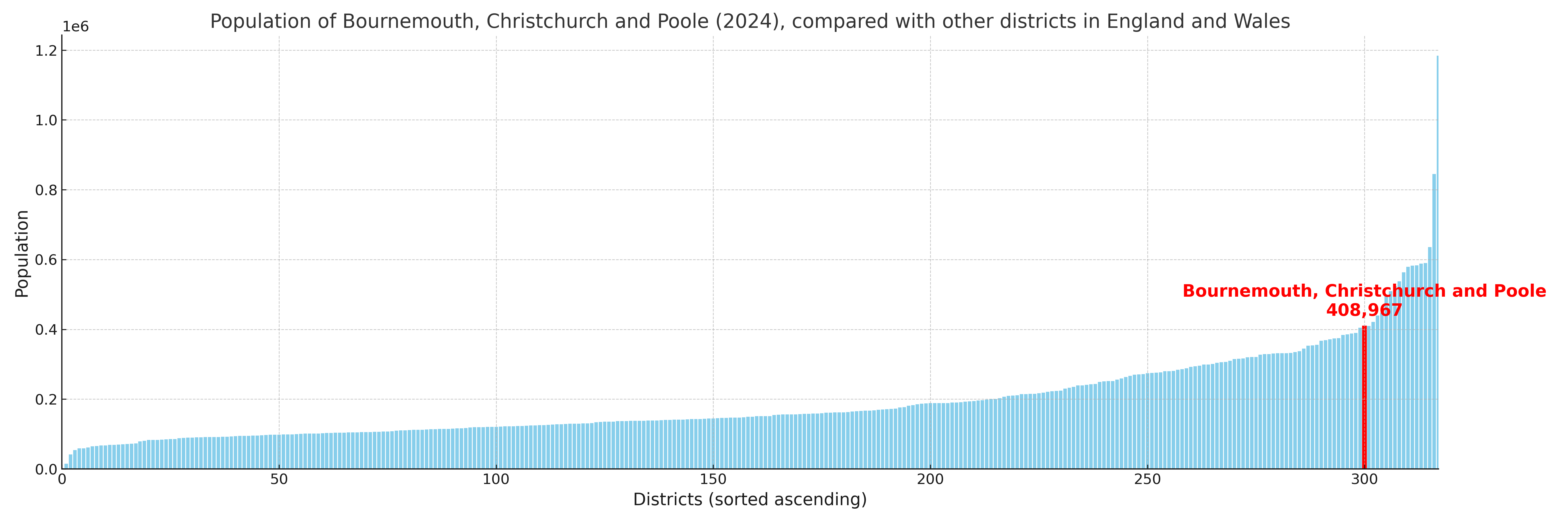
Bournemouth, Christchurch and Poole compared with other districts in the UK
This section shows how Bournemouth, Christchurch and Poole compares with other local authority districts in the UK, using a variety of measures and rankings.
Bournemouth, Christchurch and Poole has 33 electoral wards.

Bournemouth, Christchurch and Poole has a population of 408,967 (2024 mid-year estimate by ONS)
Population and Migration Trends in Bournemouth, Christchurch and Poole
This chart shows the population trend for Bournemouth, Christchurch and Poole from 2015 to 2024. It provides a quick overview of whether the local authority is growing, stable, or declining over time, and helps set context for the migration patterns shown below.
Population change is influenced by natural change (births minus deaths) and migration. The net migration chart below focuses on migration, separating internal migration (moves within the UK) from international migration (moves to and from abroad). Positive values indicate net inflows, while negative values indicate net outflows. The rate labels (per 1,000 residents) help compare migration intensity across years, even when the population size changes.
More local statistics and data for Bournemouth, Christchurch and Poole can be found on the ONS statistics for Bournemouth, Christchurch and Poole.
Latest news about Bournemouth, Christchurch and Poole
Use the search box, or suggested search phrases, below to find recent news, council updates, planning stories, housing developments, transport changes, public services news, local elections, community issues and other local developments related to Bournemouth, Christchurch and Poole. Results may include coverage from UK national, regional and local news websites, as well as official public-sector and local democracy sources.
- Bournemouth, Christchurch and Poole council
- Bournemouth, Christchurch and Poole planning
- Bournemouth, Christchurch and Poole local elections
- Bournemouth, Christchurch and Poole housing
- Bournemouth, Christchurch and Poole transport
- Bournemouth, Christchurch and Poole regeneration
- Bournemouth, Christchurch and Poole public services