East Devon
§ This page gives an overview of the East Devon local authority district, bringing together key facts, maps, and data to help you quickly understand the area. This is one of 361 LAD profiles on Baseview.
Overview ⁞ East Devon stretches from the Jurassic Coast to inland countryside, offering a mix of seaside resorts, river valleys, and market towns. The coast features towns such as Sidmouth, Seaton, and Budleigh Salterton, known for their cliffs, beaches, and promenades. Inland, Axminster and Honiton are traditional centres, with Honiton renowned for lace-making and antiques. The River Exe valley and East Devon Area of Outstanding Natural Beauty provide rolling hills, woodlands, and nature reserves. The coastline, part of a UNESCO World Heritage Site, displays dramatic geological formations, making East Devon a district of scenic variety.
East Devon Boundary Map
This map shows the official boundary of the East Devon local authority district, based on the latest geographic data published by the Office for National Statistics (ONS). It provides a clear view of the district’s extent and helps you understand how the area fits within the wider regional and national landscape.
Contains OS data © Crown copyright and database right 2025. Source: Office for National Statistics licensed under the Open Government Licence v3.0.
The administrative boundary of East Devon can also be viewed on OpenStreetMap: District Boundary of East Devon.
Key Facts about East Devon
What region is East Devon in? East Devon is in the South West of England, a region within the UK.
What county is East Devon in? East Devon is located in the county of Devon.
Is East Devon a city? No, East Devon is not a city. (Note: the UK has 76 officially designated cities.)
Who governs East Devon? The local authority for this district is: East Devon District Council - responsible for district-level services. Since Devon is a two-tier area, county-level services are handled by: Devon County Council.
▶ Official website of East Devon District Council 🔗 eastdevon.gov.uk
Which police force covers East Devon? Policing in East Devon is provided by Devon & Cornwall Police 🔗 devon-cornwall.police.uk, which serves 12 local authority districts: Cornwall ⁞ East Devon ⁞ Exeter ⁞ Isles of Scilly ⁞ Mid Devon ⁞ North Devon ⁞ Plymouth ⁞ South Hams ⁞ Teignbridge ⁞ Torbay ⁞ Torridge ⁞ West Devon.
Constituencies in East Devon
East Devon is divided into 2 parliamentary constituencies, listed below in alphabetical order.
A constituency is a specific geographical area that elects one Member of Parliament (MP) to represent them in the House of Commons. The United Kingdom is divided into 650 parliamentary constituencies. We have this list page for easy browsing of all UK parliamentary constituencies: List of Constituencies.
Wards in East Devon
East Devon is divided into 30 wards, listed below in alphabetical order.
- Axminster
- Beer & Branscombe
- Broadclyst
- Budleigh & Raleigh
- Clyst Valley
- Coly Valley
- Cranbrook
- Dunkeswell & Otterhead
- Exe Valley
- Exmouth Brixington
- Exmouth Halsdon
- Exmouth Littleham
- Exmouth Town
- Exmouth Withycombe Raleigh
- Feniton
- Honiton St Michael's
- Honiton St Paul's
- Newbridges
- Newton Poppleford & Harpford
- Ottery St Mary
- Seaton
- Sidmouth Rural
- Sidmouth Sidford
- Sidmouth Town
- Tale Vale
- Trinity
- West Hill & Aylesbeare
- Whimple & Rockbeare
- Woodbury & Lympstone
- Yarty
In the UK, a ward is a subdivision of a local authority area, used mainly for electoral and statistical purposes. Defined by the ONS, wards represent the primary unit for local elections, each returning one or more councillors to the local council. Wards are also used as a key geography for presenting population and census data. We have this list page for easy browsing of all electoral wards: List of all Electoral Wards in the UK.
Parishes in East Devon
East Devon is fully parished: 72 civil parishes, listed A-Z below.
- All Saints
- Awliscombe
- Axminster
- Axmouth
- Aylesbeare
- Beer
- Bicton
- Brampford Speke
- Branscombe
- Broad Clyst
- Broadhembury
- Buckerell
- Budleigh Salterton
- Chardstock
- Clyst Honiton
- Clyst Hydon
- Clyst St. George
- Clyst St. Lawrence
- Clyst St. Mary
- Colaton Raleigh
- Colyford
- Colyton
- Combe Raleigh
- Combpyne Rousdon
- Cotleigh
- Cranbrook
- Dalwood
- Dunkeswell
- East Budleigh
- Exmouth
- Farringdon
- Farway
- Feniton
- Gittisham
- Hawkchurch
- Honiton
- Huxham
- Kilmington
- Lands Common to Axminster and Kilmington C.P.s
- Luppitt
- Lympstone
- Membury
- Monkton
- Musbury
- Nether Exe
- Newton Poppleford and Harpford
- Northleigh
- Offwell
- Otterton
- Ottery St. Mary
- Payhembury
- Plymtree
- Poltimore
- Rewe
- Rockbeare
- Seaton
- Sheldon
- Shute
- Sidmouth
- Southleigh
- Sowton
- Stockland
- Stoke Canon
- Talaton
- Uplyme
- Upottery
- Upton Pyne
- West Hill
- Whimple
- Widworthy
- Woodbury
- Yarcombe
A civil parish is the lowest tier of local government in England, used for villages, small towns, and suburbs. They have their own local authority, either a parish council or a parish meeting, which provides local services like managing parks, allotments, and streetlights, and represents the community's views to larger councils.
We have this list page for easy browsing of all parishes: List of Civil Parishes in England and Wales.
Post Towns in East Devon
Below is a list of post towns in East Devon, grouped by postcode area:
- EX ▸ Axminster (EX13) ⁞ Budleigh Salterton (EX9) ⁞ Colyton (EX24) ⁞ Exmouth (EX8) ⁞ Honiton (EX14) ⁞ Ottery St. Mary (EX11) ⁞ Seaton (EX12) ⁞ Sidmouth (EX10)
The UK postal hierarchy begins with broad postcode areas (such as “CB” or “M”), which are divided into smaller postcode districts (such as “CB8” or “M1”) to support accurate mail routing. Each postal address is anchored by a designated post town, the official locality name used in the UK postcode system, which operates independently from Local Authority Districts —the administrative boundaries used for council tax and local government services. Because they serve different purposes, a property’s postal address and its local authority district do not always align exactly.
Built-up Areas in East Devon
East Devon covers 48 built-up areas, listed below in alphabetical order.
- Allercombe
- Axminster
- Axmouth
- Beer
- Bishopswood *
- Brampford Speke
- Broadclyst
- Budleigh Salterton
- Chardstock
- Clyst Honiton *
- Clyst St Mary
- Colaton Raleigh
- Colyford
- Colyton
- Cranbrook (East Devon)
- Dunkeswell
- East Budleigh
- Ebford
- Exeter *
- Exmouth
- Exton (East Devon)
- Farringdon
- Feniton
- Honiton
- Kilmington
- Lyme Regis *
- Lympstone
- Membury
- Musbury
- Newton Poppleford
- Offwell
- Otterton
- Ottery St Mary
- Raymond's Hill *
- Seaton (East Devon)
- Sidbury
- Sidmouth
- Smeatharpe *
- Stoke Canon
- Tipton St John
- Topsham *
- Tytherleigh
- Uplyme *
- West Clyst *
- West Hill (East Devon)
- Whimple
- Woodbury
- Woodbury Salterton
In the UK, a Built-up Area (BUA) is a continuous urban area of at least 20 hectares (0.2 km²), defined by the ONS as land where buildings are generally no more than 200 metres apart, such as towns, cities, or large villages. (Note: A BUA name marked with an asterisk (*) indicates that the area is situated partly in the district of East Devon.)
We have this list page for easy browsing of all built-up areas: List of all Built-up Areas in GB.
Railway Stations in East Devon
East Devon is served by a number of National Rail stations, providing rail connections to nearby towns, cities, and destinations across Great Britain. The railway stations listed below are located within the East Devon Local Authority District and are grouped by train operating company for clarity.
- Great Western Railway ▸ Exmouth (EX8 1BZ) ⁞ Lympstone Village (EX8 5JW) ⁞ Lympstone Commando (EX8 5AA) ⁞ Exton (EX3 0PR)
- South Western Railway ▸ Axminster (EX13 5PF) ⁞ Honiton (EX14 2DA) ⁞ Cranbrook (Devon) (EX5 2DY) ⁞ Feniton (EX14 3BT) ⁞ Whimple (EX5 2QH)
This is a district-level view only. For a complete list of all National Rail stations across Great Britain, see the UK National Rail Stations Directory.
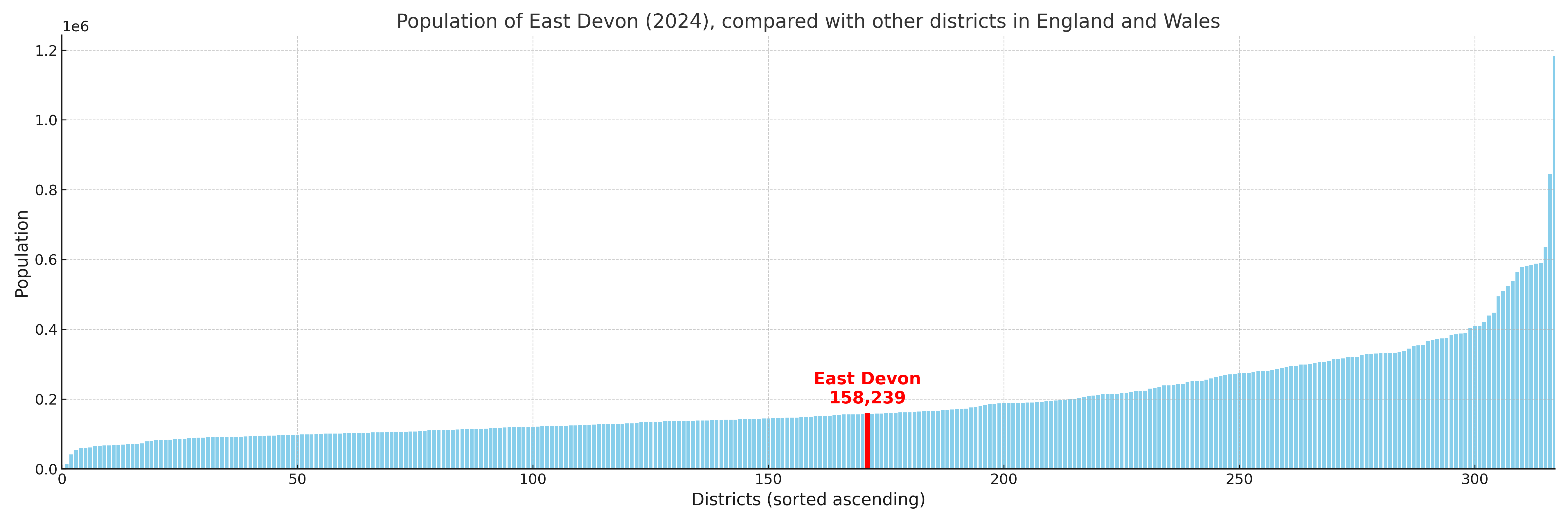
East Devon compared with other districts in the UK
This section shows how East Devon compares with other local authority districts in the UK, using a variety of measures and rankings.
East Devon has 30 electoral wards.

East Devon has a population of 158,239 (2024 mid-year estimate by ONS)
Population and Migration Trends in East Devon
This chart shows the population trend for East Devon from 2015 to 2024. It provides a quick overview of whether the local authority is growing, stable, or declining over time, and helps set context for the migration patterns shown below.
Population change is influenced by natural change (births minus deaths) and migration. The net migration chart below focuses on migration, separating internal migration (moves within the UK) from international migration (moves to and from abroad). Positive values indicate net inflows, while negative values indicate net outflows. The rate labels (per 1,000 residents) help compare migration intensity across years, even when the population size changes.
More local statistics and data for East Devon can be found on the ONS statistics for East Devon.
Latest news about East Devon
Use the search box, or suggested search phrases, below to find recent news, council updates, planning stories, housing developments, transport changes, public services news, local elections, community issues and other local developments related to East Devon. Results may include coverage from UK national, regional and local news websites, as well as official public-sector and local democracy sources.
- East Devon council
- East Devon planning
- East Devon local elections
- East Devon housing
- East Devon transport
- East Devon regeneration
- East Devon public services