Mid Devon
§ This page gives an overview of the Mid Devon local authority district, bringing together key facts, maps, and data to help you quickly understand the area. This is one of 361 LAD profiles on Baseview.
Overview ⁞ Mid Devon lies between the River Exe and River Culm valleys, a largely rural district of farmland, villages, and market towns. Tiverton is the main centre, with its castle, canal, and historic markets, while Crediton adds medieval churches and local heritage. The district is characterised by rolling hills, rivers, and patchwork fields, with the Exmoor fringe in the north. Canals, reservoirs, and historic estates are interspersed across the countryside, making it an area defined by rural charm and natural beauty.
Mid Devon Boundary Map
This map shows the official boundary of the Mid Devon local authority district, based on the latest geographic data published by the Office for National Statistics (ONS). It provides a clear view of the district’s extent and helps you understand how the area fits within the wider regional and national landscape.
Contains OS data © Crown copyright and database right 2025. Source: Office for National Statistics licensed under the Open Government Licence v3.0.
The administrative boundary of Mid Devon can also be viewed on OpenStreetMap: District Boundary of Mid Devon.
Key Facts about Mid Devon
What region is Mid Devon in? Mid Devon is in the South West of England, a region within the UK.
What county is Mid Devon in? Mid Devon is located in the county of Devon.
Is Mid Devon a city? No, Mid Devon is not a city. (Note: the UK has 76 officially designated cities.)
Who governs Mid Devon? The local authority for this district is: Mid Devon District Council - responsible for district-level services. Since Devon is a two-tier area, county-level services are handled by: Devon County Council.
▶ Official website of Mid Devon District Council 🔗 middevon.gov.uk
Which police force covers Mid Devon? Policing in Mid Devon is provided by Devon & Cornwall Police 🔗 devon-cornwall.police.uk, which serves 12 local authority districts: Cornwall ⁞ East Devon ⁞ Exeter ⁞ Isles of Scilly ⁞ Mid Devon ⁞ North Devon ⁞ Plymouth ⁞ South Hams ⁞ Teignbridge ⁞ Torbay ⁞ Torridge ⁞ West Devon.
Constituencies in Mid Devon
Mid Devon is divided into 3 parliamentary constituencies, listed below in alphabetical order.
A constituency is a specific geographical area that elects one Member of Parliament (MP) to represent them in the House of Commons. The United Kingdom is divided into 650 parliamentary constituencies. We have this list page for easy browsing of all UK parliamentary constituencies: List of Constituencies.
Wards in Mid Devon
Mid Devon is divided into 22 wards, listed below in alphabetical order.
- Bradninch
- Cadbury
- Canonsleigh
- Clare & Shuttern
- Crediton Boniface
- Crediton Lawrence
- Cullompton Padbrook
- Cullompton St Andrews
- Cullompton Vale
- Halberton
- Lower Culm
- Sandford & Creedy
- Silverton
- Taw Vale
- Tiverton Castle
- Tiverton Cranmore
- Tiverton Lowman
- Tiverton Westexe
- Upper Culm
- Upper Yeo & Taw
- Way
- Yeo
In the UK, a ward is a subdivision of a local authority area, used mainly for electoral and statistical purposes. Defined by the ONS, wards represent the primary unit for local elections, each returning one or more councillors to the local council. Wards are also used as a key geography for presenting population and census data. We have this list page for easy browsing of all electoral wards: List of all Electoral Wards in the UK.
Parishes in Mid Devon
Mid Devon is fully parished: 62 civil parishes, listed A-Z below.
- Bampton
- Bickleigh
- Bow
- Bradninch
- Brushford
- Burlescombe
- Butterleigh
- Cadbury
- Cadeleigh
- Chawleigh
- Cheriton Bishop
- Cheriton Fitzpaine
- Clannaborough
- Clayhanger
- Clayhidon
- Coldridge
- Colebrooke
- Copplestone
- Crediton
- Crediton Hamlets
- Cruwys Morchard
- Cullompton
- Culmstock
- Down St. Mary
- Eggesford
- Halberton
- Hemyock
- Hittisleigh
- Hockworthy
- Holcombe Rogus
- Huntsham
- Kennerleigh
- Kentisbeare
- Lapford
- Loxbeare
- Morchard Bishop
- Morebath
- Newton St. Cyres
- Nymet Rowland
- Oakford
- Poughill
- Puddington
- Sampford Peverell
- Sandford
- Shobrooke
- Silverton
- Stockleigh English
- Stockleigh Pomeroy
- Stoodleigh
- Templeton
- Thelbridge
- Thorverton
- Tiverton
- Uffculme
- Uplowman
- Upton Hellions
- Washfield
- Washford Pyne
- Wembworthy
- Willand
- Woolfardisworthy
- Zeal Monachorum
A civil parish is the lowest tier of local government in England, used for villages, small towns, and suburbs. They have their own local authority, either a parish council or a parish meeting, which provides local services like managing parks, allotments, and streetlights, and represents the community's views to larger councils.
We have this list page for easy browsing of all parishes: List of Civil Parishes in England and Wales.
Post Towns in Mid Devon
Below is a list of post towns in Mid Devon, grouped by postcode area:
- EX ▸ Crediton (EX17) ⁞ Cullompton (EX15) ⁞ Tiverton (EX16)
The UK postal hierarchy begins with broad postcode areas (such as “CB” or “M”), which are divided into smaller postcode districts (such as “CB8” or “M1”) to support accurate mail routing. Each postal address is anchored by a designated post town, the official locality name used in the UK postcode system, which operates independently from Local Authority Districts —the administrative boundaries used for council tax and local government services. Because they serve different purposes, a property’s postal address and its local authority district do not always align exactly.
Built-up Areas in Mid Devon
Mid Devon covers 29 built-up areas, listed below in alphabetical order.
- Bampton (Mid Devon)
- Bow
- Bradninch
- Chawleigh
- Cheriton Bishop *
- Cheriton Fitzpaine
- Copplestone
- Crediton
- Cullompton
- Culmstock
- Halberton
- Hemyock
- Holcombe Rogus
- Kentisbeare
- Lapford
- Morchard Bishop
- Newton St Cyres
- Sampford Peverell
- Sandford (Mid Devon)
- Silverton
- Smeatharpe *
- Stoneyford
- Thorverton
- Tiverton
- Uffculme
- Westleigh
- Willand
- Witheridge *
- Zeal Monachorum
In the UK, a Built-up Area (BUA) is a continuous urban area of at least 20 hectares (0.2 km²), defined by the ONS as land where buildings are generally no more than 200 metres apart, such as towns, cities, or large villages. (Note: A BUA name marked with an asterisk (*) indicates that the area is situated partly in the district of Mid Devon.)
We have this list page for easy browsing of all built-up areas: List of all Built-up Areas in GB.
Railway Stations in Mid Devon
Mid Devon is served by a number of National Rail stations, providing rail connections to nearby towns, cities, and destinations across Great Britain. The railway stations listed below are located within the Mid Devon Local Authority District and are grouped by train operating company for clarity.
- Great Western Railway ▸ Tiverton Parkway (EX16 7EH) ⁞ Crediton (EX17 3BY) ⁞ Eggesford (EX18 7JZ) ⁞ Copplestone (EX17 5NE) ⁞ Morchard Road (EX17 5LR) ⁞ Yeoford (EX17 5JB) ⁞ Lapford (EX17 6QU) ⁞ Newton St Cyres (EX5 5AP)
This is a district-level view only. For a complete list of all National Rail stations across Great Britain, see the UK National Rail Stations Directory.
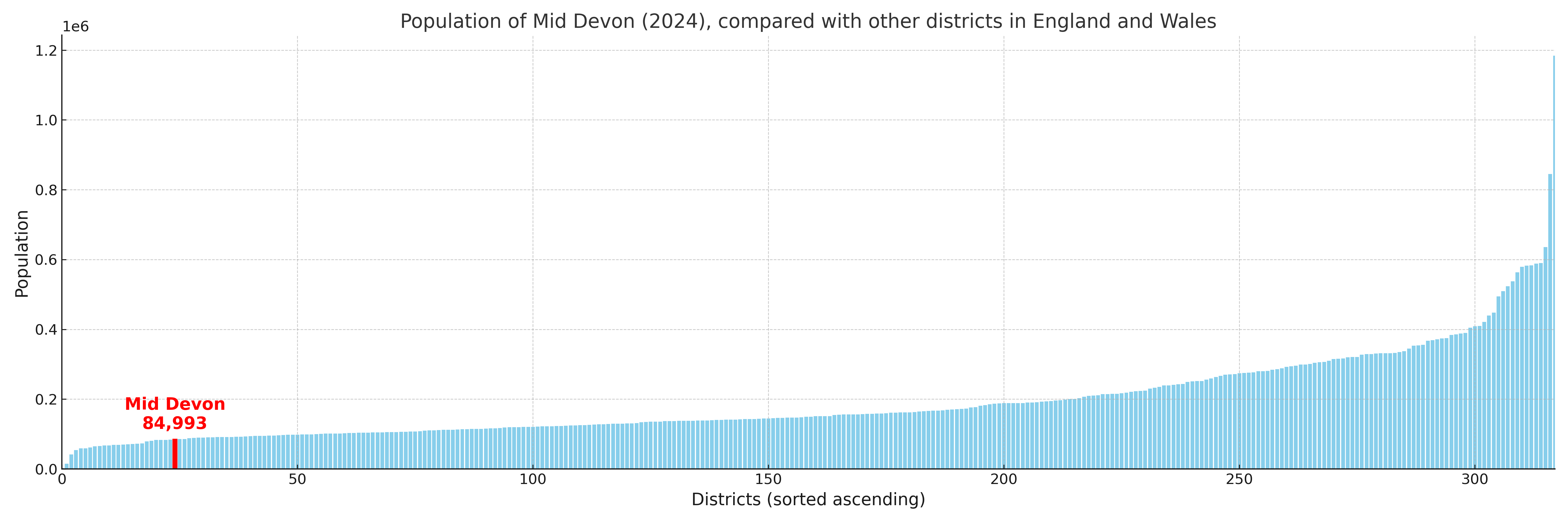
Mid Devon compared with other districts in the UK
This section shows how Mid Devon compares with other local authority districts in the UK, using a variety of measures and rankings.
Mid Devon has 22 electoral wards.

Mid Devon has a population of 84,993 (2024 mid-year estimate by ONS)
Population and Migration Trends in Mid Devon
This chart shows the population trend for Mid Devon from 2015 to 2024. It provides a quick overview of whether the local authority is growing, stable, or declining over time, and helps set context for the migration patterns shown below.
Population change is influenced by natural change (births minus deaths) and migration. The net migration chart below focuses on migration, separating internal migration (moves within the UK) from international migration (moves to and from abroad). Positive values indicate net inflows, while negative values indicate net outflows. The rate labels (per 1,000 residents) help compare migration intensity across years, even when the population size changes.
More local statistics and data for Mid Devon can be found on the ONS statistics for Mid Devon.
Latest news about Mid Devon
Use the search box, or suggested search phrases, below to find recent news, council updates, planning stories, housing developments, transport changes, public services news, local elections, community issues and other local developments related to Mid Devon. Results may include coverage from UK national, regional and local news websites, as well as official public-sector and local democracy sources.
- Mid Devon council
- Mid Devon planning
- Mid Devon local elections
- Mid Devon housing
- Mid Devon transport
- Mid Devon regeneration
- Mid Devon public services