City of Bristol
§ This page gives an overview of the City of Bristol local authority district, bringing together key facts, maps, and data to help you quickly understand the area. This is one of 361 LAD profiles on Baseview.
Overview ⁞ Bristol is a vibrant city on the River Avon, known for its maritime history, cultural scene, and engineering landmarks. The harbourside has been transformed into a hub of museums, galleries, and restaurants, including the SS Great Britain and M Shed museum. The Clifton Suspension Bridge spans the dramatic Avon Gorge, a symbol of the city. Bristol features diverse neighbourhoods, historic churches, and street art, including works by Banksy. Parks, hills, and riverside trails provide green spaces, while the city’s position near the Severn Estuary shapes its landscape.
What County is Bristol in?
Bristol is not part of any other county. It is officially known as the City and County of Bristol, a ceremonial county and unitary authority in its own right. This means Bristol manages its own local government services and is not administratively part of neighbouring counties such as Somerset or Gloucestershire.
Historically, Bristol had close links with both Somerset and Gloucestershire, and from 1974 to 1996 it formed part of the now-abolished county of Avon. However, since 1996, Bristol has stood alone as a county for ceremonial purposes. As a result, although historic and informal references may still associate Bristol with surrounding counties, the correct modern answer is that Bristol is its own county.
City of Bristol Boundary Map
This map shows the official boundary of the City of Bristol local authority district, based on the latest geographic data published by the Office for National Statistics (ONS). It provides a clear view of the district’s extent and helps you understand how the area fits within the wider regional and national landscape.
Contains OS data © Crown copyright and database right 2025. Source: Office for National Statistics licensed under the Open Government Licence v3.0.
The administrative boundary of City of Bristol can also be viewed on OpenStreetMap: District Boundary of City of Bristol.
Key Facts about City of Bristol
What region is City of Bristol in? City of Bristol is in the South West of England, a region within the United Kingdom.
What county is Bristol, City of in? Bristol, City of is in the county of Bristol.
Is Bristol, City of a city? Yes, Bristol, City of is a city. Bristol, City of holds official city status as one of the 76 designated cities in the UK.
Who governs City of Bristol? The local government for this district is: Bristol City Council (Unitary Authority).
▶ Official website of Bristol City Council 🔗 bristol.gov.uk
Which police force covers Bristol, City of? Policing in Bristol, City of is provided by Avon and Somerset Constabulary 🔗 avonandsomerset.police.uk, which serves 5 local authority districts: Bath and North East Somerset ⁞ Bristol, City of ⁞ North Somerset ⁞ Somerset ⁞ South Gloucestershire.
City of Bristol in International Geographies
In the International Territorial Levels (ITLs) hierarchy, Bristol, City of is an ITLs Level 3 area:
- (ITL 1) South West
- (ITL 2) ⇒ West of England
- (ITL 3) ⇒⇒ Bristol, City of
The International Territorial Levels are used by OECD member countries for statistical purposes to classify administrative areas. We have this listable page for easy browsing of ITL names and codes: International Territorial Levels.
Constituencies in City of Bristol
City of Bristol is divided into 5 parliamentary constituencies, listed below in alphabetical order.
A constituency is a specific geographical area that elects one Member of Parliament (MP) to represent them in the House of Commons. The United Kingdom is divided into 650 parliamentary constituencies. We have this list page for easy browsing of all UK parliamentary constituencies: List of Constituencies.
Wards in City of Bristol
City of Bristol is divided into 34 wards, listed below in alphabetical order.
- Ashley
- Avonmouth and Lawrence Weston
- Bedminster
- Bishopston and Ashley Down
- Bishopsworth
- Brislington East
- Brislington West
- Central
- Clifton
- Clifton Down
- Cotham
- Easton
- Eastville
- Filwood
- Frome Vale
- Hartcliffe and Withywood
- Henbury and Brentry
- Hengrove and Whitchurch Park
- Hillfields
- Horfield
- Hotwells and Harbourside
- Knowle
- Lawrence Hill
- Lockleaze
- Redland
- Southmead
- Southville
- St George Central
- St George Troopers Hill
- St George West
- Stockwood
- Stoke Bishop
- Westbury-on-Trym and Henleaze
- Windmill Hill
In the UK, a ward is a subdivision of a local authority area, used mainly for electoral and statistical purposes. Defined by the ONS, wards represent the primary unit for local elections, each returning one or more councillors to the local council. Wards are also used as a key geography for presenting population and census data. We have this list page for easy browsing of all electoral wards: List of all Electoral Wards in the UK.
Parishes in City of Bristol
City of Bristol is entirely unparished—there are no civil parishes in this local authority district.
Parishes are the lowest tier of local government; where they don’t exist, those very local services and representation sit directly with the principal council. We have this list page for easy browsing of all parishes: List of Civil Parishes in England and Wales.
Post Towns in City of Bristol
Below is a list of post towns in Bristol, City of, grouped by postcode area:
BS ▸ Bristol (BS0 / BS1 / BS2 / BS3 / BS4 / BS5 / BS6 / BS7 / BS8 / BS9 / BS10 / BS11 / BS13 / BS14 / BS15 / BS16 / BS20 / BS30 / BS31 / BS32 / BS34 / BS35 / BS36 / BS37 / BS39 / BS40 / BS41 / BS48 / BS49 / BS80 / BS98 / BS99)
The UK postal hierarchy begins with broad postcode areas (such as “CB” or “M”), which are divided into smaller postcode districts (such as “CB8” or “M1”) to support accurate mail routing. Each postal address is anchored by a designated post town, the official locality name used in the UK postcode system, which operates independently from Local Authority Districts —the administrative boundaries used for council tax and local government services. Because they serve different purposes, a property’s postal address and its local authority district do not always align exactly.
Built-up Areas in City of Bristol
City of Bristol covers 9 built-up areas, listed below in alphabetical order.
- Avonmouth *
- Bristol *
- Filton *
- Kingswood and Fishponds *
- Pill *
- Portishead *
- Severn Beach *
- Stoke Gifford *
- Whitchurch (Bath and North East Somerset) *
In the UK, a Built-up Area (BUA) is a continuous urban area of at least 20 hectares (0.2 km²), defined by the ONS as land where buildings are generally no more than 200 metres apart, such as towns, cities, or large villages. (Note: A BUA name marked with an asterisk (*) indicates that the area is situated partly in the district of City of Bristol.)
We have this list page for easy browsing of all built-up areas: List of all Built-up Areas in GB.
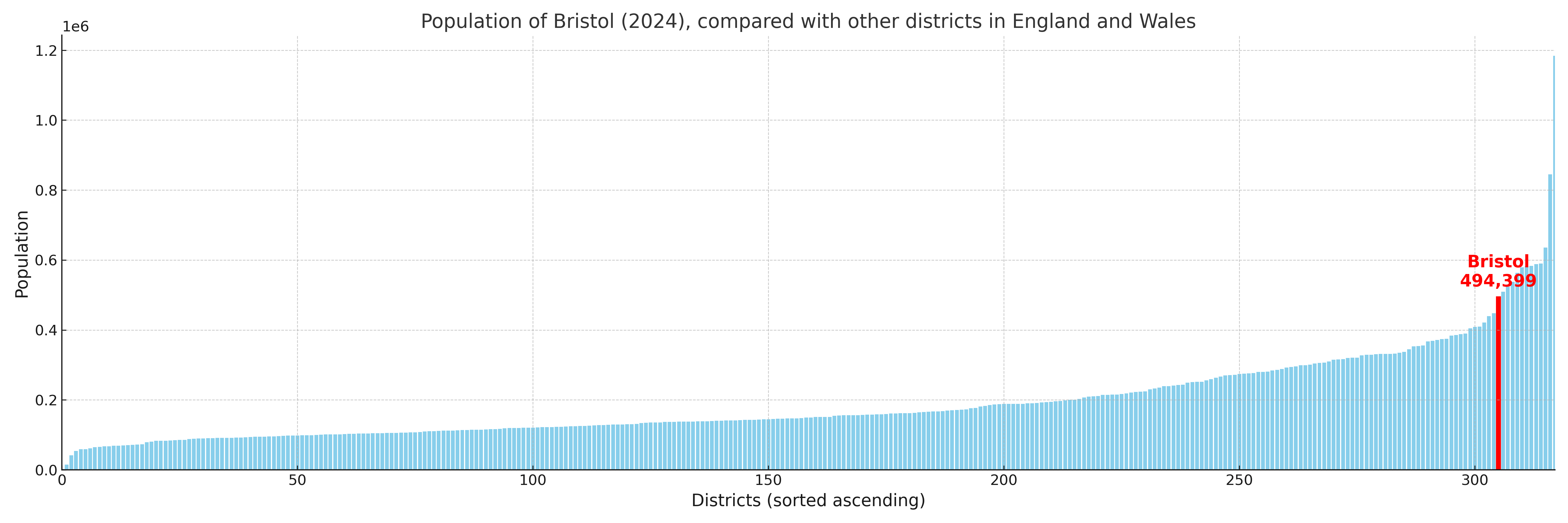
City of Bristol compared with other districts in the UK
This section shows how City of Bristol compares with other local authority districts in the UK, using a variety of measures and rankings.
City of Bristol has 34 electoral wards.

City of Bristol has a population of 494,399 (2024 mid-year estimate by ONS)
Population and Migration Trends in City of Bristol
This chart shows the population trend for City of Bristol from 2015 to 2024. It provides a quick overview of whether the local authority is growing, stable, or declining over time, and helps set context for the migration patterns shown below.
Population change is influenced by natural change (births minus deaths) and migration. The net migration chart below focuses on migration, separating internal migration (moves within the UK) from international migration (moves to and from abroad). Positive values indicate net inflows, while negative values indicate net outflows. The rate labels (per 1,000 residents) help compare migration intensity across years, even when the population size changes.
More local statistics and data for City of Bristol can be found on the ONS statistics for City of Bristol.
Latest news about City of Bristol
Use the search box, or suggested search phrases, below to find recent news, council updates, planning stories, housing developments, transport changes, public services news, local elections, community issues and other local developments related to City of Bristol. Results may include coverage from UK national, regional and local news websites, as well as official public-sector and local democracy sources.
- City of Bristol council
- City of Bristol planning
- City of Bristol local elections
- City of Bristol housing
- City of Bristol transport
- City of Bristol regeneration
- City of Bristol public services