Stroud
§ This page gives an overview of the Stroud local authority district, bringing together key facts, maps, and data to help you quickly understand the area. This is one of 361 LAD profiles on Baseview.
Overview ⁞ Stroud lies in the Cotswolds, surrounded by steep valleys, woodland, and farmland. Known for its artistic community, the town centre has markets, galleries, and cafes. The Five Valleys converge here, offering scenic walking routes and canal paths, while nearby villages such as Painswick and Minchinhampton add charm with stone cottages and historic churches. The district’s rolling hills, commons, and canals reflect both natural beauty and industrial heritage.
Stroud Boundary Map
This map shows the official boundary of the Stroud local authority district, based on the latest geographic data published by the Office for National Statistics (ONS). It provides a clear view of the district’s extent and helps you understand how the area fits within the wider regional and national landscape.
Contains OS data © Crown copyright and database right 2025. Source: Office for National Statistics licensed under the Open Government Licence v3.0.
The administrative boundary of Stroud can also be viewed on OpenStreetMap: District Boundary of Stroud.
Key Facts about Stroud
What region is Stroud in? Stroud is in the South West of England, a region within the UK.
What county is Stroud in? Stroud is located in the county of Gloucestershire.
Is Stroud a city? No, Stroud is not a city. (Note: the UK has 76 officially designated cities.)
Who governs Stroud? The local authority for this district is: Stroud District Council - responsible for district-level services. Since Gloucestershire is a two-tier area, county-level services are handled by: Gloucestershire County Council.
▶ Official website of Stroud District Council 🔗 stroud.gov.uk
Which police force covers Stroud? Policing in Stroud is provided by Gloucestershire Constabulary 🔗 gloucestershire.police.uk, which serves 6 local authority districts: Cheltenham ⁞ Cotswold ⁞ Forest of Dean ⁞ Gloucester ⁞ Stroud ⁞ Tewkesbury.
Constituencies in Stroud
Stroud is divided into 3 parliamentary constituencies, listed below in alphabetical order.
A constituency is a specific geographical area that elects one Member of Parliament (MP) to represent them in the House of Commons. The United Kingdom is divided into 650 parliamentary constituencies. We have this list page for easy browsing of all UK parliamentary constituencies: List of Constituencies.
Wards in Stroud
Stroud is divided into 27 wards, listed below in alphabetical order.
- Amberley and Woodchester
- Berkeley Vale
- Bisley
- Cainscross
- Cam East
- Cam West
- Chalford
- Coaley and Uley
- Dursley
- Hardwicke
- Kingswood
- Minchinhampton
- Nailsworth
- Painswick and Upton
- Randwick, Whiteshill and Ruscombe
- Rodborough
- Severn
- Stonehouse
- Stroud Central
- Stroud Farmhill and Paganhill
- Stroud Slade
- Stroud Trinity
- Stroud Uplands
- Stroud Valley
- The Stanleys
- Thrupp
- Wotton-under-Edge
In the UK, a ward is a subdivision of a local authority area, used mainly for electoral and statistical purposes. Defined by the ONS, wards represent the primary unit for local elections, each returning one or more councillors to the local council. Wards are also used as a key geography for presenting population and census data. We have this list page for easy browsing of all electoral wards: List of all Electoral Wards in the UK.
Parishes in Stroud
Stroud is fully parished: 54 civil parishes, listed A-Z below.
- Alderley
- Alkington
- Arlingham
- Berkeley
- Bisley-with-Lypiatt
- Brimscombe and Thrupp
- Brookthorpe-with-Whaddon
- Cainscross
- Cam
- Chalford
- Coaley
- Cranham
- Dursley
- Eastington
- Elmore
- Frampton on Severn
- Fretherne with Saul
- Frocester
- Great Oldbury
- Ham and Stone
- Hamfallow
- Hardwicke
- Harescombe
- Haresfield
- Hillesley and Tresham
- Hinton
- Horsley
- Hunts Grove
- King's Stanley
- Kingswood
- Leonard Stanley
- Longney and Epney
- Minchinhampton
- Miserden
- Moreton Valence
- Nailsworth
- North Nibley
- Nympsfield
- Owlpen
- Painswick
- Pitchcombe
- Randwick and Westrip
- Rodborough
- Slimbridge
- Standish
- Stinchcombe
- Stonehouse
- Stroud
- Uley
- Upton St. Leonards
- Whiteshill and Ruscombe
- Whitminster
- Woodchester
- Wotton-under-Edge
A civil parish is the lowest tier of local government in England, used for villages, small towns, and suburbs. They have their own local authority, either a parish council or a parish meeting, which provides local services like managing parks, allotments, and streetlights, and represents the community's views to larger councils.
We have this list page for easy browsing of all parishes: List of Civil Parishes in England and Wales.
Post Towns in Stroud
Below is a list of post towns in Stroud, grouped by postcode area:
- GL ▸ Berkeley (GL13) ⁞ Dursley (GL11) ⁞ Stonehouse (GL10) ⁞ Stroud (GL5 / GL6) ⁞ Wotton-under-Edge (GL11 / GL12)
The UK postal hierarchy begins with broad postcode areas (such as “CB” or “M”), which are divided into smaller postcode districts (such as “CB8” or “M1”) to support accurate mail routing. Each postal address is anchored by a designated post town, the official locality name used in the UK postcode system, which operates independently from Local Authority Districts —the administrative boundaries used for council tax and local government services. Because they serve different purposes, a property’s postal address and its local authority district do not always align exactly.
Built-up Areas in Stroud
Stroud covers 49 built-up areas, listed below in alphabetical order.
- Amberley (Stroud)
- Bagpath
- Berkeley
- Bisley (Stroud)
- Box (Stroud)
- Brimscombe and Thrupp
- Brockworth *
- Cam
- Cambridge (Stroud)
- Chalford *
- Charfield *
- Clapton
- Dursley
- Eastington
- Edge
- Frampton on Severn
- Gloucester *
- Hardwicke
- Haresfield
- Hillesley
- Horsley (Stroud)
- Kingswood (Stroud)
- Leonard Stanley and King's Stanley
- Middleyard
- Minchinhampton
- Nailsworth
- North Nibley
- Nympsfield
- Oakridge Lynch
- Painswick
- Quedgeley and Hardwicke *
- Ryeford
- Saul
- Sharpness
- Sheepscombe
- Slimbridge
- Stone (Stroud)
- Stonehouse (Stroud)
- Stroud
- Uley
- Upthorpe (Stroud)
- Upton St Leonards
- Whaddon (Stroud) *
- Whiteshill and Randwick
- Whiteway
- Whitminster
- Wickwar *
- Woodchester
- Wotton-under-Edge
In the UK, a Built-up Area (BUA) is a continuous urban area of at least 20 hectares (0.2 km²), defined by the ONS as land where buildings are generally no more than 200 metres apart, such as towns, cities, or large villages. (Note: A BUA name marked with an asterisk (*) indicates that the area is situated partly in the district of Stroud.)
We have this list page for easy browsing of all built-up areas: List of all Built-up Areas in GB.
Railway Stations in Stroud
Stroud is served by a number of National Rail stations, providing rail connections to nearby towns, cities, and destinations across Great Britain. The railway stations listed below are located within the Stroud Local Authority District and are grouped by train operating company for clarity.
- Great Western Railway ▸ Stroud (Gloucs) (GL5 3AP) ⁞ Cam and Dursley (GL11 5DJ) ⁞ Stonehouse (GL10 2JW)
This is a district-level view only. For a complete list of all National Rail stations across Great Britain, see the UK National Rail Stations Directory.
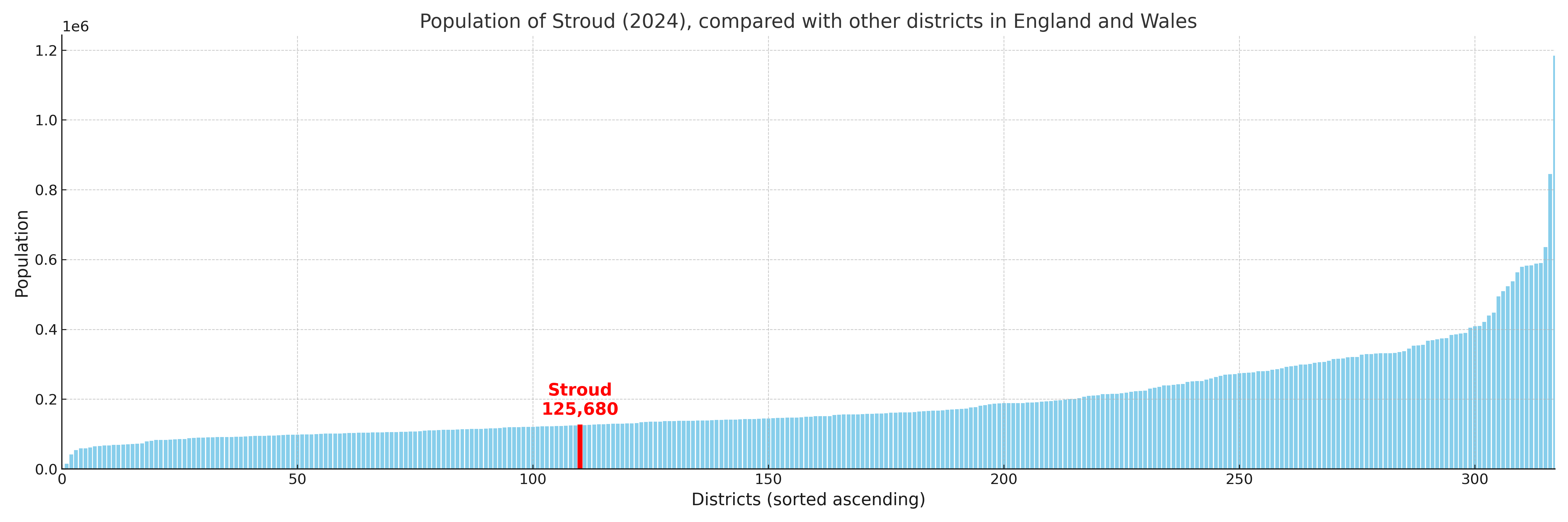
Stroud compared with other districts in the UK
This section shows how Stroud compares with other local authority districts in the UK, using a variety of measures and rankings.
Stroud has 27 electoral wards.

Stroud has a population of 125,680 (2024 mid-year estimate by ONS)
Population and Migration Trends in Stroud
This chart shows the population trend for Stroud from 2015 to 2024. It provides a quick overview of whether the local authority is growing, stable, or declining over time, and helps set context for the migration patterns shown below.
Population change is influenced by natural change (births minus deaths) and migration. The net migration chart below focuses on migration, separating internal migration (moves within the UK) from international migration (moves to and from abroad). Positive values indicate net inflows, while negative values indicate net outflows. The rate labels (per 1,000 residents) help compare migration intensity across years, even when the population size changes.
More local statistics and data for Stroud can be found on the ONS statistics for Stroud.
Latest news about Stroud
Use the search box, or suggested search phrases, below to find recent news, council updates, planning stories, housing developments, transport changes, public services news, local elections, community issues and other local developments related to Stroud. Results may include coverage from UK national, regional and local news websites, as well as official public-sector and local democracy sources.
- Stroud council
- Stroud planning
- Stroud local elections
- Stroud housing
- Stroud transport
- Stroud regeneration
- Stroud public services