North Devon
§ This page gives an overview of the North Devon local authority district, bringing together key facts, maps, and data to help you quickly understand the area. This is one of 361 LAD profiles on Baseview.
Overview ⁞ North Devon combines rugged coastline, sandy beaches, and dramatic countryside. The Atlantic coast features surfing hubs like Croyde, Woolacombe, and Saunton Sands, along with the historic port town of Ilfracombe. The Exmoor National Park extends into the district, offering moorland, wooded valleys, and the picturesque village of Lynton and Lynmouth, connected by a cliff railway. Inland, Barnstaple is the main town, with markets, museums, and the River Taw. The Tarka Trail provides cycling and walking routes through estuaries and countryside. North Devon’s diverse geography blends wild coastlines with rural tranquillity.
North Devon Boundary Map
This map shows the official boundary of the North Devon local authority district, based on the latest geographic data published by the Office for National Statistics (ONS). It provides a clear view of the district’s extent and helps you understand how the area fits within the wider regional and national landscape.
Contains OS data © Crown copyright and database right 2025. Source: Office for National Statistics licensed under the Open Government Licence v3.0.
The administrative boundary of North Devon can also be viewed on OpenStreetMap: District Boundary of North Devon.
Key Facts about North Devon
What region is North Devon in? North Devon is in the South West of England, a region within the UK.
What county is North Devon in? North Devon is located in the county of Devon.
Is North Devon a city? No, North Devon is not a city. (Note: the UK has 76 officially designated cities.)
Who governs North Devon? The local authority for this district is: North Devon District Council - responsible for district-level services. Since Devon is a two-tier area, county-level services are handled by: Devon County Council.
▶ Official website of North Devon District Council 🔗 northdevon.gov.uk
Which police force covers North Devon? Policing in North Devon is provided by Devon & Cornwall Police 🔗 devon-cornwall.police.uk, which serves 12 local authority districts: Cornwall ⁞ East Devon ⁞ Exeter ⁞ Isles of Scilly ⁞ Mid Devon ⁞ North Devon ⁞ Plymouth ⁞ South Hams ⁞ Teignbridge ⁞ Torbay ⁞ Torridge ⁞ West Devon.
Constituencies in North Devon
North Devon is divided into 1 parliamentary constituencies, listed below in alphabetical order.
A constituency is a specific geographical area that elects one Member of Parliament (MP) to represent them in the House of Commons. The United Kingdom is divided into 650 parliamentary constituencies. We have this list page for easy browsing of all UK parliamentary constituencies: List of Constituencies.
Wards in North Devon
North Devon is divided into 25 wards, listed below in alphabetical order.
- Barnstaple Central
- Barnstaple with Pilton
- Barnstaple with Westacott
- Bickington
- Bishop's Nympton
- Bratton Fleming
- Braunton East
- Braunton West & Georgeham
- Chittlehampton
- Chulmleigh
- Combe Martin
- Fremington
- Heanton Punchardon
- Ilfracombe East
- Ilfracombe West
- Instow
- Landkey
- Lynton & Lynmouth
- Marwood
- Mortehoe
- Newport
- North Molton
- Roundswell
- South Molton
- Witheridge
In the UK, a ward is a subdivision of a local authority area, used mainly for electoral and statistical purposes. Defined by the ONS, wards represent the primary unit for local elections, each returning one or more councillors to the local council. Wards are also used as a key geography for presenting population and census data. We have this list page for easy browsing of all electoral wards: List of all Electoral Wards in the UK.
Parishes in North Devon
North Devon is fully parished: 62 civil parishes, listed A-Z below.
- Arlington
- Ashford
- Atherington
- Barnstaple
- Berrynarbor
- Bishop's Nympton
- Bishop's Tawton
- Bittadon
- Bratton Fleming
- Braunton
- Brayford
- Brendon and Countisbury
- Burrington
- Challacombe
- Chittlehamholt
- Chittlehampton
- Chulmleigh
- Combe Martin
- East and West Buckland
- East Anstey
- East Down
- East Worlington
- Filleigh
- Fremington
- George Nympton
- Georgeham
- Goodleigh
- Heanton Punchardon
- Horwood, Lovacott and Newton Tracey
- Ilfracombe
- Instow
- Kentisbury
- King's Nympton
- Knowstone
- Landkey
- Loxhore
- Lynton and Lynmouth
- Mariansleigh
- Martinhoe
- Marwood
- Meshaw
- Molland
- Mortehoe
- North Molton
- Parracombe
- Pilton West
- Queen's Nympton
- Rackenford
- Romansleigh
- Rose Ash
- Satterleigh and Warkleigh
- Shirwell
- South Molton
- Stoke Rivers
- Swimbridge
- Tawstock
- Trentishoe
- Twitchen
- West Anstey
- West Down
- Westleigh
- Witheridge
A civil parish is the lowest tier of local government in England, used for villages, small towns, and suburbs. They have their own local authority, either a parish council or a parish meeting, which provides local services like managing parks, allotments, and streetlights, and represents the community's views to larger councils.
We have this list page for easy browsing of all parishes: List of Civil Parishes in England and Wales.
Post Towns in North Devon
Below is a list of post towns in North Devon, grouped by postcode area:
- EX ▸ Barnstaple (EX31 / EX32) ⁞ Braunton (EX33) ⁞ Ilfracombe (EX34) ⁞ Lynmouth (EX35) ⁞ Lynton (EX35) ⁞ South Molton (EX36) ⁞ Umberleigh (EX37) ⁞ Woolacombe (EX34)
The UK postal hierarchy begins with broad postcode areas (such as “CB” or “M”), which are divided into smaller postcode districts (such as “CB8” or “M1”) to support accurate mail routing. Each postal address is anchored by a designated post town, the official locality name used in the UK postcode system, which operates independently from Local Authority Districts —the administrative boundaries used for council tax and local government services. Because they serve different purposes, a property’s postal address and its local authority district do not always align exactly.
Built-up Areas in North Devon
North Devon covers 26 built-up areas, listed below in alphabetical order.
- Ashford (North Devon)
- Barnstaple
- Bickington
- Bishop's Tawton
- Bratton Fleming
- Braunton
- Chambercombe
- Chivenor and Wrafton
- Chulmleigh
- Combe Martin
- Croyde
- East Buckland
- Fremington
- Georgeham
- Goodleigh
- Hill
- Ilfracombe
- Instow
- Landkey
- Lynton and Lynmouth
- North Molton
- South Molton
- Swimbridge
- Westacott
- Witheridge *
- Woolacombe
In the UK, a Built-up Area (BUA) is a continuous urban area of at least 20 hectares (0.2 km²), defined by the ONS as land where buildings are generally no more than 200 metres apart, such as towns, cities, or large villages. (Note: A BUA name marked with an asterisk (*) indicates that the area is situated partly in the district of North Devon.)
We have this list page for easy browsing of all built-up areas: List of all Built-up Areas in GB.
Railway Stations in North Devon
North Devon is served by a number of National Rail stations, providing rail connections to nearby towns, cities, and destinations across Great Britain. The railway stations listed below are located within the North Devon Local Authority District and are grouped by train operating company for clarity.
- Great Western Railway ▸ Barnstaple (EX31 2AU) ⁞ Umberleigh (EX37 9AB) ⁞ Kings Nympton (EX37 9EU) ⁞ Chapelton (Devon) (EX37 9DZ)
This is a district-level view only. For a complete list of all National Rail stations across Great Britain, see the UK National Rail Stations Directory.
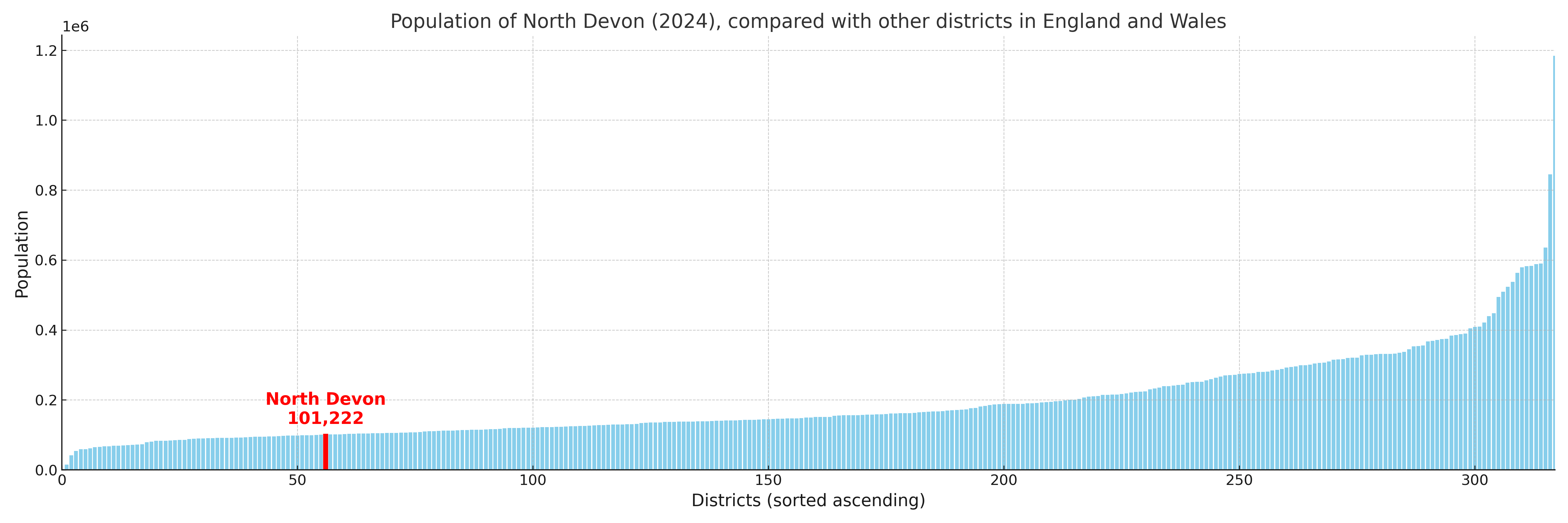
North Devon compared with other districts in the UK
This section shows how North Devon compares with other local authority districts in the UK, using a variety of measures and rankings.
North Devon has 25 electoral wards.

North Devon has a population of 101,222 (2024 mid-year estimate by ONS)
Population and Migration Trends in North Devon
This chart shows the population trend for North Devon from 2015 to 2024. It provides a quick overview of whether the local authority is growing, stable, or declining over time, and helps set context for the migration patterns shown below.
Population change is influenced by natural change (births minus deaths) and migration. The net migration chart below focuses on migration, separating internal migration (moves within the UK) from international migration (moves to and from abroad). Positive values indicate net inflows, while negative values indicate net outflows. The rate labels (per 1,000 residents) help compare migration intensity across years, even when the population size changes.
More local statistics and data for North Devon can be found on the ONS statistics for North Devon.
Latest news about North Devon
Use the search box, or suggested search phrases, below to find recent news, council updates, planning stories, housing developments, transport changes, public services news, local elections, community issues and other local developments related to North Devon. Results may include coverage from UK national, regional and local news websites, as well as official public-sector and local democracy sources.
- North Devon council
- North Devon planning
- North Devon local elections
- North Devon housing
- North Devon transport
- North Devon regeneration
- North Devon public services