Cotswold
§ This page gives an overview of the Cotswold local authority district, bringing together key facts, maps, and data to help you quickly understand the area. This is one of 361 LAD profiles on Baseview.
Overview ⁞ The Cotswold district is a landscape of limestone hills, villages, and historic market towns. Cirencester, often called the “Capital of the Cotswolds,” is the main town, with Roman history and Georgian architecture. Picturesque villages such as Bourton-on-the-Water, Stow-on-the-Wold, and Chipping Campden are famed for honey-coloured stone cottages, medieval churches, and vibrant markets. The rolling hills, valleys, and woodlands form part of the Cotswolds Area of Outstanding Natural Beauty, offering walking trails and scenic countryside. Rivers such as the Windrush and Coln wind through, enhancing the district’s rural charm.
Cotswold Boundary Map
This map shows the official boundary of the Cotswold local authority district, based on the latest geographic data published by the Office for National Statistics (ONS). It provides a clear view of the district’s extent and helps you understand how the area fits within the wider regional and national landscape.
Contains OS data © Crown copyright and database right 2025. Source: Office for National Statistics licensed under the Open Government Licence v3.0.
The administrative boundary of Cotswold can also be viewed on OpenStreetMap: District Boundary of Cotswold.
Key Facts about Cotswold
What region is Cotswold in? Cotswold is in the South West of England, a region within the UK.
What county is Cotswold in? Cotswold is located in the county of Gloucestershire.
Is Cotswold a city? No, Cotswold is not a city. (Note: the UK has 76 officially designated cities.)
Who governs Cotswold? The local authority for this district is: Cotswold District Council - responsible for district-level services. Since Gloucestershire is a two-tier area, county-level services are handled by: Gloucestershire County Council.
▶ Official website of Cotswold District Council 🔗 cotswold.gov.uk
Which police force covers Cotswold? Policing in Cotswold is provided by Gloucestershire Constabulary 🔗 gloucestershire.police.uk, which serves 6 local authority districts: Cheltenham ⁞ Cotswold ⁞ Forest of Dean ⁞ Gloucester ⁞ Stroud ⁞ Tewkesbury.
Constituencies in Cotswold
Cotswold is divided into 2 parliamentary constituencies, listed below in alphabetical order.
A constituency is a specific geographical area that elects one Member of Parliament (MP) to represent them in the House of Commons. The United Kingdom is divided into 650 parliamentary constituencies. We have this list page for easy browsing of all UK parliamentary constituencies: List of Constituencies.
Wards in Cotswold
Cotswold is divided into 32 wards, listed below in alphabetical order.
- Abbey
- Blockley
- Bourton Vale
- Bourton Village
- Campden & Vale
- Chedworth & Churn Valley
- Chesterton
- Coln Valley
- Ermin
- Fairford North
- Fosseridge
- Four Acres
- Grumbolds Ash with Avening
- Kemble
- Lechlade, Kempsford & Fairford South
- Moreton East
- Moreton West
- New Mills
- Northleach
- Sandywell
- Siddington & Cerney Rural
- South Cerney Village
- St Michael's
- Stow
- Stratton
- Tetbury East & Rural
- Tetbury Town
- Tetbury with Upton
- The Ampneys & Hampton
- The Beeches
- The Rissingtons
- Watermoor
In the UK, a ward is a subdivision of a local authority area, used mainly for electoral and statistical purposes. Defined by the ONS, wards represent the primary unit for local elections, each returning one or more councillors to the local council. Wards are also used as a key geography for presenting population and census data. We have this list page for easy browsing of all electoral wards: List of all Electoral Wards in the UK.
Parishes in Cotswold
Cotswold is fully parished: 116 civil parishes, listed A-Z below.
- Adlestrop
- Aldsworth
- Ampney Crucis
- Ampney St. Mary
- Ampney St. Peter
- Andoversford
- Ashley
- Aston Subedge
- Avening
- Bagendon
- Barnsley
- Barrington
- Batsford
- Baunton
- Beverston
- Bibury
- Birdlip
- Bledington
- Blockley
- Bourton-on-the-Hill
- Bourton-on-the-Water
- Boxwell with Leighterton
- Brimpsfield
- Broadwell
- Chedworth
- Cherington
- Chipping Campden
- Cirencester
- Clapton
- Coates
- Coberley
- Cold Aston
- Colesbourne
- Coln St. Aldwyns
- Coln St. Dennis
- Compton Abdale
- Condicote
- Cowley
- Cutsdean
- Daglingworth
- Didmarton
- Donnington
- Dowdeswell
- Down Ampney
- Driffield
- Duntisbourne Abbots
- Duntisbourne Rouse
- Eastleach
- Ebrington
- Edgeworth
- Elkstone
- Evenlode
- Fairford
- Farmington
- Great Rissington
- Guiting Power
- Hampnett
- Hatherop
- Hazleton
- Icomb
- Kemble and Ewen
- Kempsford
- Kingscote
- Lechlade
- Little Rissington
- Long Newnton
- Longborough
- Lower Slaughter
- Maiseyhampton
- Maugersbury
- Mickleton
- Moreton-in-Marsh
- Naunton
- North Cerney
- Northleach with Eastington
- Notgrove
- Oddington
- Ozleworth
- Poole Keynes
- Poulton
- Preston
- Quenington
- Rendcomb
- Rodmarton
- Saintbury
- Sapperton
- Sevenhampton
- Sezincote
- Sherborne
- Shipton
- Shipton Moyne
- Siddington
- Somerford Keynes
- South Cerney
- Southrop
- Stow-on-the-Wold
- Swell
- Syde
- Temple Guiting
- Tetbury
- Tetbury Upton
- Todenham
- Turkdean
- Upper Rissington
- Upper Slaughter
- Westcote
- Weston Subedge
- Westonbirt with Lasborough
- Whittington
- Wick Rissington
- Willersey
- Windrush
- Winson
- Winstone
- Withington
- Yanworth
A civil parish is the lowest tier of local government in England, used for villages, small towns, and suburbs. They have their own local authority, either a parish council or a parish meeting, which provides local services like managing parks, allotments, and streetlights, and represents the community's views to larger councils.
We have this list page for easy browsing of all parishes: List of Civil Parishes in England and Wales.
Post Towns in Cotswold
Below is a list of post towns in Cotswold, grouped by postcode area:
- GL ▸ Chipping Campden (GL55) ⁞ Cirencester (GL7) ⁞ Fairford (GL7) ⁞ Lechlade (GL7) ⁞ Moreton-in-Marsh (GL56) ⁞ Tetbury (GL8)
The UK postal hierarchy begins with broad postcode areas (such as “CB” or “M”), which are divided into smaller postcode districts (such as “CB8” or “M1”) to support accurate mail routing. Each postal address is anchored by a designated post town, the official locality name used in the UK postcode system, which operates independently from Local Authority Districts —the administrative boundaries used for council tax and local government services. Because they serve different purposes, a property’s postal address and its local authority district do not always align exactly.
Built-up Areas in Cotswold
Cotswold covers 53 built-up areas, listed below in alphabetical order.
- Ampney Crucis
- Andoversford
- Arlington
- Avening
- Bentham *
- Beverston
- Bledington *
- Blockley
- Bourton-on-the-Water
- Broadwell
- Chalford *
- Chedworth
- Chipping Campden
- Cirencester
- Coates
- Down Ampney *
- Dunfield *
- Eastleach Turville
- Ebrington
- Ewen
- Fairford
- Great Rissington
- Guiting Power
- Hatherop
- Kemble
- Kempsford *
- Lechlade-on-Thames
- Leckhampton Hill
- Longborough
- Meon Vale *
- Meysey Hampton
- Mickleton (Cotswold)
- Moreton-in-Marsh
- Naunton
- Northleach
- Paxford
- Poulton
- Quenington
- Rendcomb
- Rodmarton *
- Shipton (Cotswold)
- Siddington
- Somerford Keynes
- South Cerney *
- Southrop
- Stow-on-the-Wold
- Stratton (Cotswold)
- Tetbury
- Upper Oddington
- Upper Rissington *
- Weston-sub-Edge *
- Westonbirt *
- Willersey
In the UK, a Built-up Area (BUA) is a continuous urban area of at least 20 hectares (0.2 km²), defined by the ONS as land where buildings are generally no more than 200 metres apart, such as towns, cities, or large villages. (Note: A BUA name marked with an asterisk (*) indicates that the area is situated partly in the district of Cotswold.)
We have this list page for easy browsing of all built-up areas: List of all Built-up Areas in GB.
Railway Stations in Cotswold
Cotswold is served by a number of National Rail stations, providing rail connections to nearby towns, cities, and destinations across Great Britain. The railway stations listed below are located within the Cotswold Local Authority District and are grouped by train operating company for clarity.
- Great Western Railway ▸ Kemble (GL7 6AW) ⁞ Moreton-In-Marsh (GL56 0AA)
This is a district-level view only. For a complete list of all National Rail stations across Great Britain, see the UK National Rail Stations Directory.
Cotswold compared with other districts in the UK
This section shows how Cotswold compares with other local authority districts in the UK, using a variety of measures and rankings.
Cotswold has 32 electoral wards.

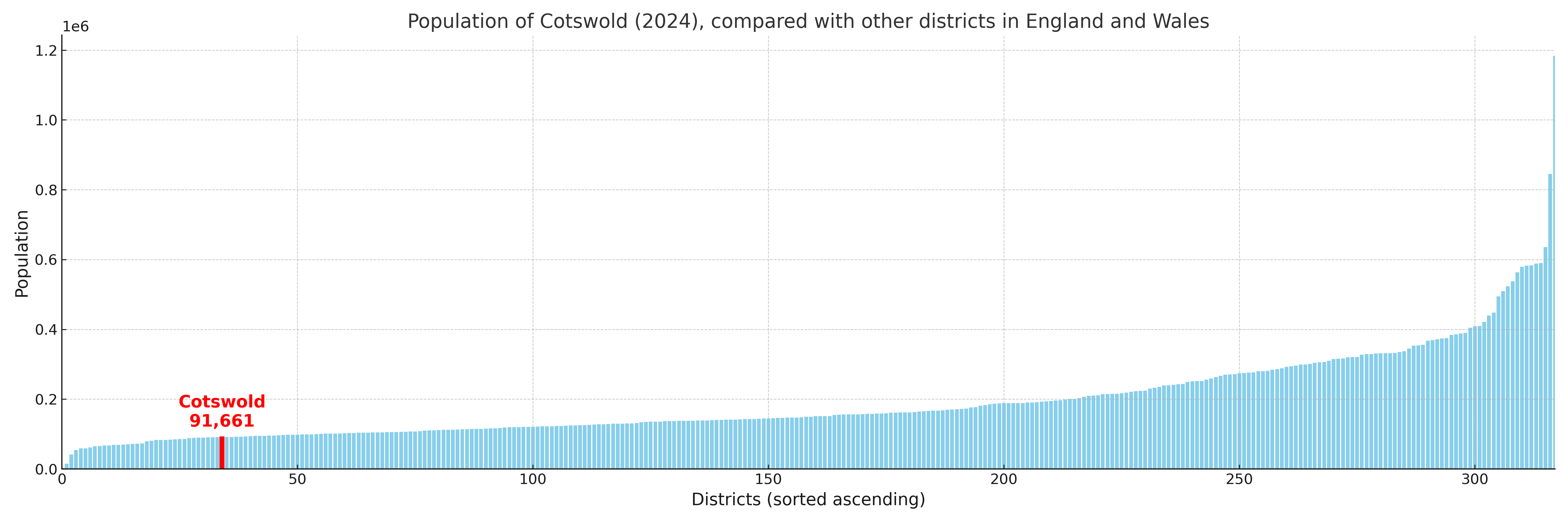
Cotswold has a population of 91,661 (2024 mid-year estimate by ONS)
Population and Migration Trends in Cotswold
This chart shows the population trend for Cotswold from 2015 to 2024. It provides a quick overview of whether the local authority is growing, stable, or declining over time, and helps set context for the migration patterns shown below.
Population change is influenced by natural change (births minus deaths) and migration. The net migration chart below focuses on migration, separating internal migration (moves within the UK) from international migration (moves to and from abroad). Positive values indicate net inflows, while negative values indicate net outflows. The rate labels (per 1,000 residents) help compare migration intensity across years, even when the population size changes.
More local statistics and data for Cotswold can be found on the ONS statistics for Cotswold.
Latest news about Cotswold
Use the search box, or suggested search phrases, below to find recent news, council updates, planning stories, housing developments, transport changes, public services news, local elections, community issues and other local developments related to Cotswold. Results may include coverage from UK national, regional and local news websites, as well as official public-sector and local democracy sources.
- Cotswold council
- Cotswold planning
- Cotswold local elections
- Cotswold housing
- Cotswold transport
- Cotswold regeneration
- Cotswold public services