Somerset
§ This page gives an overview of the Somerset local authority district, bringing together key facts, maps, and data to help you quickly understand the area. This is one of 361 LAD profiles on Baseview.
Overview ⁞ Somerset is a large and varied county district known for its rolling hills, wetlands, and historic towns. It encompasses the Mendip Hills, Quantock Hills, and Blackdown Hills, alongside the wide Somerset Levels, an expanse of wetlands rich in birdlife. Key towns include Taunton, Yeovil, Bridgwater, and Frome, while Glastonbury is famed for its Tor and Abbey, and Wells for its stunning cathedral. The coast along the Bristol Channel includes seaside resorts like Minehead and the dramatic cliffs of Exmoor. Ancient landmarks such as Cheddar Gorge and Wookey Hole add geological interest, while the patchwork farmland and historic villages define its rural character.
Somerset Boundary Map
This map shows the official boundary of the Somerset local authority district, based on the latest geographic data published by the Office for National Statistics (ONS). It provides a clear view of the district’s extent and helps you understand how the area fits within the wider regional and national landscape.
Contains OS data © Crown copyright and database right 2025. Source: Office for National Statistics licensed under the Open Government Licence v3.0.
The administrative boundary of Somerset can also be viewed on OpenStreetMap: District Boundary of Somerset.
Key Facts about Somerset
What region is Somerset in? Somerset is in the South West of England, a region within the UK.
What county is Somerset in? Somerset is in the county of Somerset.
Is Somerset a city? Yes, Somerset is a city. Somerset holds official city status as one of the 76 designated cities in the UK.
Who governs Somerset? The local government for this district is: Somerset Council (Unitary Authority).
▶ Official website of Somerset Council 🔗 somerset.gov.uk
Which police force covers Somerset? Policing in Somerset is provided by Avon and Somerset Constabulary 🔗 avonandsomerset.police.uk, which serves 5 local authority districts: Bath and North East Somerset ⁞ Bristol, City of ⁞ North Somerset ⁞ Somerset ⁞ South Gloucestershire.
Somerset in International Geographies
In the International Territorial Levels (ITLs) hierarchy, Somerset is within one of ITLs Level 2 area, North Somerset, Somerset and Dorset, that contains the following 5 ITLs Level 3 areas:
(ITL 1) South West
(ITL 2) ⇒ West of England
(ITL 3) ⇒⇒ Bath & North East Somerset and South Gloucestershire
(ITL 1) South West
(ITL 2) ⇒ North Somerset, Somerset and Dorset
(ITL 3) ⇒⇒ North Somerset ⁞ Somerset ⁞ Bournemouth, Christchurch and Poole ⁞ Dorset
The International Territorial Levels are used by OECD member countries for statistical purposes to classify administrative areas. We have this listable page for easy browsing of ITL names and codes: International Territorial Levels.
Constituencies in Somerset
Somerset is divided into 7 parliamentary constituencies, listed below in alphabetical order.
- Bridgwater
- Frome and East Somerset
- Glastonbury and Somerton
- Taunton and Wellington
- Tiverton and Minehead
- Wells and Mendip Hills
- Yeovil
A constituency is a specific geographical area that elects one Member of Parliament (MP) to represent them in the House of Commons. The United Kingdom is divided into 650 parliamentary constituencies. We have this list page for easy browsing of all UK parliamentary constituencies: List of Constituencies.
Wards in Somerset
Somerset is divided into 55 wards, listed below in alphabetical order.
- Bishop's Hull & Taunton West
- Blackdown & Neroche
- Blackmoor Vale
- Brent
- Bridgwater East & Bawdrip
- Bridgwater North & Central
- Bridgwater South
- Bridgwater West
- Brympton
- Burnham on Sea North
- Cannington
- Castle Cary
- Chard North
- Chard South
- Cheddar
- Coker
- Comeytrowe & Trull
- Crewkerne
- Curry Rivel & Langport
- Dulverton & Exmoor
- Dunster
- Frome East
- Frome North
- Frome West
- Glastonbury
- Highbridge & Burnham South
- Huntspill
- Ilminster
- King Alfred
- Lydeard
- Martock
- Mendip Central and East
- Mendip Hills
- Mendip South
- Mendip West
- Minehead
- Monkton & North Curry
- North Petherton
- Rowbarton & Staplegrove
- Shepton Mallet
- Somerton
- South Petherton & Islemoor
- Street
- Taunton East
- Taunton North
- Taunton South
- Upper Tone
- Watchet & Stogursey
- Wellington
- Wells
- Wincanton & Bruton
- Yeovil Central
- Yeovil East
- Yeovil South
- Yeovil West
In the UK, a ward is a subdivision of a local authority area, used mainly for electoral and statistical purposes. Defined by the ONS, wards represent the primary unit for local elections, each returning one or more councillors to the local council. Wards are also used as a key geography for presenting population and census data. We have this list page for easy browsing of all electoral wards: List of all Electoral Wards in the UK.
Parishes in Somerset
Somerset is fully parished: 328 civil parishes, listed A-Z below.
- Abbas and Templecombe
- Alford
- Aller
- Ansford
- Ash
- Ash Priors
- Ashbrittle
- Ashcott
- Ashill
- Ashwick
- Axbridge
- Babcary
- Badgworth
- Baltonsborough
- Barrington
- Barton St. David
- Barwick and Stoford
- Batcombe
- Bathealton
- Bawdrip
- Beckington
- Beercrocombe
- Berkley
- Berrow
- Bickenhall
- Bicknoller
- Binegar
- Bishop's Hull
- Bishop's Lydeard
- Bradford-on-Tone
- Bratton Seymour
- Brean
- Brent Knoll
- Brewham
- Bridgwater
- Bridgwater Without
- Broadway
- Brompton Ralph
- Brompton Regis
- Broomfield
- Brushford
- Bruton
- Brympton
- Buckland Dinham
- Buckland St Mary
- Burnham Without
- Burnham-on-Sea and Highbridge
- Burrowbridge
- Burtle
- Butleigh
- Cannington
- Carhampton
- Castle Cary
- Catcott
- Chaffcombe
- Chapel Allerton
- Chard Town
- Charlton Horethorne
- Charlton Musgrove
- Cheddar
- Cheddon Fitzpaine
- Chedzoy
- Chewton Mendip
- Chilcompton
- Chillington
- Chilthorne Domer
- Chilton Cantelo
- Chilton Polden
- Chilton Trinity
- Chipstable
- Chiselborough
- Churchstanton
- Clatworthy
- Closworth
- Coleford
- Combe Florey
- Combe St Nicholas
- Compton Bishop
- Compton Dundon
- Compton Pauncefoot
- Corfe
- Corton Denham
- Cossington
- Cotford St Luke
- Cothelstone
- Cranmore
- Creech St. Michael
- Crewkerne
- Cricket St. Thomas
- Croscombe
- Crowcombe
- Cucklington
- Cudworth
- Curland
- Curry Mallet
- Curry Rivel
- Cutcombe
- Dinnington
- Ditcheat
- Donyatt
- Doulting
- Dowlish Wake
- Downhead
- Drayton
- Dulverton
- Dunster
- Durleigh
- Durston
- East Brent
- East Chinnock
- East Coker
- East Huntspill
- East Pennard
- East Quantoxhead
- Edington
- Elworthy
- Emborough
- Enmore
- Evercreech
- Exford
- Exmoor
- Exton
- Fiddington
- Fitzhead
- Fivehead
- Frome
- Glastonbury
- Goathurst
- Godney
- Great Elm
- Greinton
- Halse
- Hambridge and Westport
- Hardington Mandeville
- Haselbury Plucknett
- Hatch Beauchamp
- Hemington
- Henstridge
- High Ham
- Hinton St. George
- Holcombe
- Holford
- Holton
- Horsington
- Horton
- Huish Champflower
- Huish Episcopi
- Ilchester
- Ilminster
- Ilton
- Isle Abbotts
- Isle Brewers
- Keinton Mandeville
- Kilmersdon
- Kilve
- Kingsbury Episcopi
- Kingsdon
- Kingston St. Mary
- Kingstone
- Kingweston
- Knowle St. Giles
- Lamyatt
- Langford Budville
- Langport
- Leigh-on-Mendip
- Litton
- Long Load
- Long Sutton
- Lopen
- Lovington
- Luccombe
- Lullington
- Luxborough
- Lydeard St. Lawrence
- Lydford-on-Fosse
- Lympsham
- Lyng
- Maperton
- Mark
- Marston Magna
- Martock
- Meare
- Mells
- Merriott
- Middlezoy
- Milborne Port
- Milton Clevedon
- Milverton
- Minehead
- Minehead Without
- Misterton
- Monksilver
- Montacute
- Moorlinch
- Muchelney
- Mudford
- Nether Stowey
- Nettlecombe
- North Barrow
- North Cadbury
- North Cheriton
- North Curry
- North Perrott
- North Petherton
- North Wootton
- Norton Fitzwarren
- Norton St Philip
- Norton sub Hamdon
- Nunney
- Nynehead
- Oake
- Oare
- Odcombe
- Old Cleeve
- Orchard Portman
- Othery
- Otterford
- Otterhampton
- Over Stowey
- Pawlett
- Pen Selwood
- Pilton
- Pitcombe
- Pitminster
- Pitney
- Porlock
- Priddy
- Puckington
- Puriton
- Pylle
- Queen Camel
- Rimpton
- Rode
- Rodney Stoke
- Ruishton
- Sampford Arundel
- Sampford Brett
- Seavington St Mary
- Seavington St Michael
- Selwood
- Selworthy
- Shapwick
- Sharpham
- Shepton Beauchamp
- Shepton Mallet
- Shepton Montague
- Shipham
- Skilgate
- Somerton
- South Barrow
- South Cadbury and Sutton Montis
- South Petherton
- Sparkford
- Spaxton
- St Cuthbert Out
- Staple Fitzpaine
- Stawell
- Stawley
- Stockland Bristol
- Stocklinch
- Stogumber
- Stogursey
- Stoke St Michael
- Stoke St. Gregory
- Stoke St. Mary
- Stoke sub Hamdon
- Stoke Trister
- Ston Easton
- Stratton on the Fosse
- Street
- Stringston
- Tatworth and Forton
- Taunton
- Tellisford
- The Charltons
- Thornfalcon
- Thurloxton
- Timberscombe
- Tintinhull
- Tolland
- Treborough
- Trudoxhill
- Trull
- Upton
- Upton Noble
- Walton
- Wambrook
- Wanstrow
- Watchet
- Wayford
- Weare
- Wedmore
- Wellington
- Wellington Without
- Wells
- Wembdon
- West and Middle Chinnock
- West Bagborough
- West Bradley
- West Buckland
- West Camel
- West Coker
- West Crewkerne
- West Hatch
- West Huntspill
- West Monkton
- West Pennard
- West Quantoxhead
- Westbury
- Westonzoyland
- Whatley
- Whitelackington
- Whitestaunton
- Williton
- Wincanton
- Winsford
- Winsham
- Witham Friary
- Withycombe
- Withypool and Hawkridge
- Wiveliscombe
- Wookey
- Woolavington
- Wootton Courtenay
- Yarlington
- Yeovil
- Yeovil Without
- Yeovilton and District
A civil parish is the lowest tier of local government in England, used for villages, small towns, and suburbs. They have their own local authority, either a parish council or a parish meeting, which provides local services like managing parks, allotments, and streetlights, and represents the community's views to larger councils.
We have this list page for easy browsing of all parishes: List of Civil Parishes in England and Wales.
Post Towns in Somerset
Below is a list of post towns in Somerset, grouped by postcode area:
- BA ▸ Bruton (BA9 / BA10) ⁞ Castle Cary (BA7) ⁞ Frome (BA11) ⁞ Glastonbury (BA6) ⁞ Shepton Mallet (BA4) ⁞ Street (BA16) ⁞ Templecombe (BA8) ⁞ Wells (BA5) ⁞ Wincanton (BA9) ⁞ Yeovil (BA20 / BA21 / BA22)
- BS ▸ Axbridge (BS26) ⁞ Cheddar (BS27) ⁞ Wedmore (BS28)
- TA ▸ Bridgwater (TA5 / TA6 / TA7) ⁞ Burnham-on-Sea (TA8) ⁞ Chard (TA20) ⁞ Crewkerne (TA18) ⁞ Dulverton (TA22) ⁞ Highbridge (TA9) ⁞ Hinton St. George (TA17) ⁞ Ilminster (TA19) ⁞ Langport (TA10) ⁞ Martock (TA12) ⁞ Merriott (TA16) ⁞ Minehead (TA24) ⁞ Montacute (TA15) ⁞ Somerton (TA11) ⁞ South Petherton (TA13) ⁞ Stoke-sub-Hamdon (TA14) ⁞ Taunton (TA1 / TA2 / TA3 / TA4) ⁞ Watchet (TA23) ⁞ Wellington (TA21)
The UK postal hierarchy begins with broad postcode areas (such as “CB” or “M”), which are divided into smaller postcode districts (such as “CB8” or “M1”) to support accurate mail routing. Each postal address is anchored by a designated post town, the official locality name used in the UK postcode system, which operates independently from Local Authority Districts —the administrative boundaries used for council tax and local government services. Because they serve different purposes, a property’s postal address and its local authority district do not always align exactly.
Built-up Areas in Somerset
Somerset covers 207 built-up areas, listed below in alphabetical order.
- Ash (South Somerset)
- Ashcott
- Axbridge
- Baltonsborough
- Barrington (South Somerset)
- Barton St David
- Barwick and Stoford *
- Batcombe (Mendip)
- Bathpool
- Bawdrip
- Beckington
- Berrow and Brean
- Bicknoller
- Bishops Lydeard
- Bishopswood *
- Blackford (Sedgemoor)
- Blagdon Hill
- Bleadon *
- Blue Anchor
- Bourton (Dorset) *
- Bradford-on-Tone
- Brent Knoll
- Bridgwater
- Brushford
- Bruton
- Buckland Dinham
- Burnham-on-Sea
- Burton (South Somerset)
- Butleigh
- Cannington
- Carhampton
- Castle Cary
- Catcott and Edington
- Chapmanslade *
- Chard
- Charlton Adam
- Charlton Horethorne
- Charlton Mackrell
- Cheddar
- Chedzoy
- Chelston
- Chilcompton
- Chilthorne Domer
- Chilton Cantelo
- Chilton Polden
- Cocklake
- Coleford (Mendip)
- Combe St Nicholas
- Combwich
- Compass
- Compton Dundon
- Cossington (Sedgemoor)
- Cotford St Luke
- Coxley (Mendip)
- Creech St Michael
- Crewkerne
- Croscombe
- Cross
- Crowcombe
- Curry Rivel
- Ditcheat
- Draycott
- Drayton (South Somerset)
- Dulverton
- Dunball
- Dunster
- East Brent
- East Chinnock
- East Huntspill
- Easton (Mendip)
- Edgarley
- Edithmead
- Evercreech
- Exford
- Farrington Gurney *
- Fivehead
- Frome
- Galhampton
- Glastonbury
- Gurney Slade
- Halse
- Hardington Mandeville
- Haselbury Plucknett
- Hatch Beauchamp
- Henstridge
- Henstridge Marsh *
- Henton
- High Ham
- Highbridge
- Hillcommon
- Hinton St George
- Holcombe (Mendip)
- Horton and Broadway
- Huntspill
- Ilchester
- Ilminster
- Ilton
- Keinton Mandeville
- Kilve
- Kingsbury Episcopi
- Kingsdon
- Kingston St Mary
- Langford Budville
- Langport
- Long Load
- Long Sutton (South Somerset)
- Lower Weare
- Lye's Green *
- Lympsham
- Mark
- Mark Causeway
- Marston Magna
- Martock
- Meare
- Meare Green
- Mells
- Merriott
- Middlezoy
- Midsomer Norton *
- Milborne Port
- Milverton
- Minehead
- Misterton (South Somerset)
- Monkton Heathfield
- Montacute
- Moorland
- Nether Stowey
- North Cadbury
- North Curry
- North Newton
- North Perrott
- North Petherton
- Norton Fitzwarren
- Norton St Philip
- Norton sub Hamdon
- Nunney
- Oakhill
- Odcombe
- Othery
- Over Stratton
- Pawlett
- Pecking Mill
- Pilton
- Pitney
- Porlock
- Puriton
- Queen Camel
- Radstock *
- Rockwell Green
- Rode
- Rooks Bridge
- Ruishton
- Seavington St Michael
- Shapwick
- Shepton Beauchamp
- Shepton Mallet
- Shipham
- Shurton
- Somerton
- South Horrington
- South Petherton
- Sparkford
- Spaxton
- Staplegrove
- Stogumber
- Stogursey
- Stoke St Mary
- Stoke St Michael
- Stoke sub Hamdon
- Stoney Stratton
- Stratton-on-the-Fosse
- Street
- Tatworth *
- Taunton
- Templecombe
- Theale (Sedgemoor)
- Tintinhull
- Trull
- Upper Coxley and Coxley Wick
- Wadeford
- Walton (Mendip)
- Washford
- Watchet
- Weare
- Wedmore
- Wellington (Somerset West and Taunton)
- Wells
- Wembdon
- West Camel
- West Chinnock
- West Coker
- West Monkton
- West Pennard
- West Quantoxhead
- Westbury-sub-Mendip
- Westonzoyland
- Williton
- Wincanton
- Winscombe and Sandford *
- Winsham
- Wiveliscombe
- Wookey
- Wookey Hole
- Woolavington
- Wootton Courtenay
- Yeovil *
- Yeovilton
In the UK, a Built-up Area (BUA) is a continuous urban area of at least 20 hectares (0.2 km²), defined by the ONS as land where buildings are generally no more than 200 metres apart, such as towns, cities, or large villages. (Note: A BUA name marked with an asterisk (*) indicates that the area is situated partly in the district of Somerset.)
We have this list page for easy browsing of all built-up areas: List of all Built-up Areas in GB.
Railway Stations in Somerset
Somerset is served by a number of National Rail stations, providing rail connections to nearby towns, cities, and destinations across Great Britain. The railway stations listed below are located within the Somerset Local Authority District and are grouped by train operating company for clarity.
- Great Western Railway ▸ Taunton (TA1 1QP) ⁞ Bridgwater (TA6 5HB) ⁞ Castle Cary (BA7 7PE) ⁞ Frome (BA11 1RE) ⁞ Highbridge and Burnham (TA9 3BT) ⁞ Yeovil Pen Mill (BA21 5DD) ⁞ Bruton (BA10 0EH)
- South Western Railway ▸ Yeovil Junction (BA22 9UU) ⁞ Crewkerne (TA18 8AU) ⁞ Templecombe (BA8 0JR)
- West Somerset Railway ▸ Bishops Lydeard (TA4 3BX)
This is a district-level view only. For a complete list of all National Rail stations across Great Britain, see the UK National Rail Stations Directory.
Somerset compared with other districts in the UK
This section shows how Somerset compares with other local authority districts in the UK, using a variety of measures and rankings.
Somerset has 55 electoral wards.

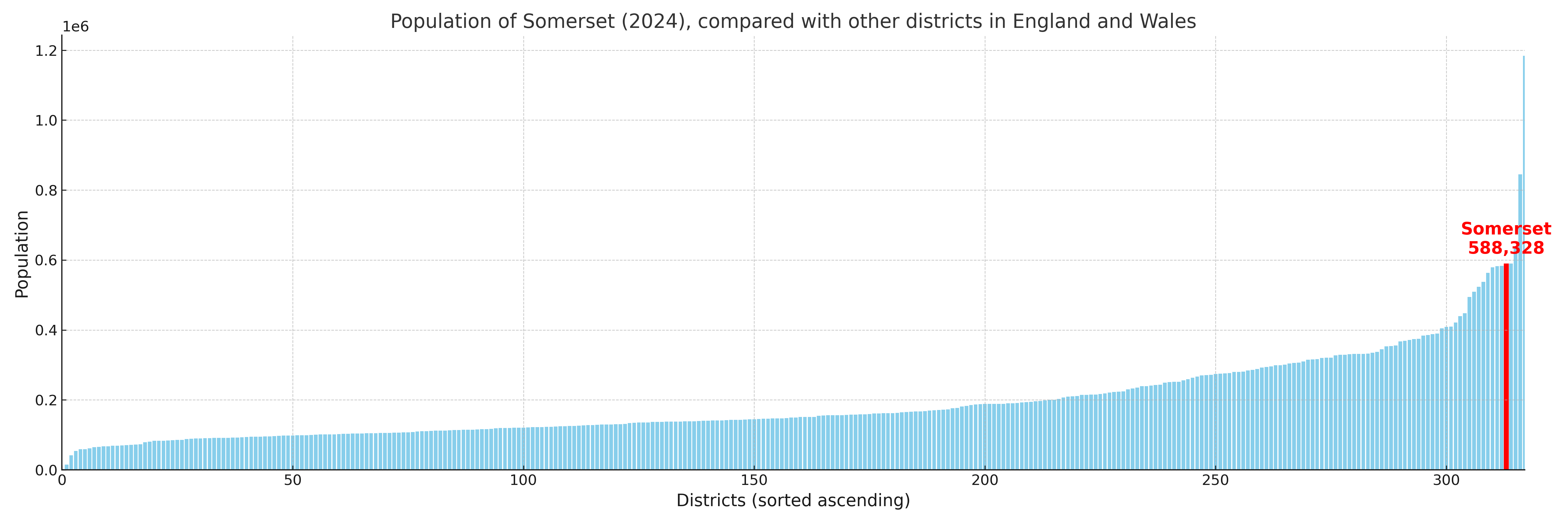
Somerset has a population of 588,328 (2024 mid-year estimate by ONS)
Population and Migration Trends in Somerset
This chart shows the population trend for Somerset from 2015 to 2024. It provides a quick overview of whether the local authority is growing, stable, or declining over time, and helps set context for the migration patterns shown below.
Population change is influenced by natural change (births minus deaths) and migration. The net migration chart below focuses on migration, separating internal migration (moves within the UK) from international migration (moves to and from abroad). Positive values indicate net inflows, while negative values indicate net outflows. The rate labels (per 1,000 residents) help compare migration intensity across years, even when the population size changes.
More local statistics and data for Somerset can be found on the ONS statistics for Somerset.
Latest news about Somerset
Use the search box, or suggested search phrases, below to find recent news, council updates, planning stories, housing developments, transport changes, public services news, local elections, community issues and other local developments related to Somerset. Results may include coverage from UK national, regional and local news websites, as well as official public-sector and local democracy sources.
- Somerset council
- Somerset planning
- Somerset local elections
- Somerset housing
- Somerset transport
- Somerset regeneration
- Somerset public services