South Gloucestershire
§ This page gives an overview of the South Gloucestershire local authority district, bringing together key facts, maps, and data to help you quickly understand the area. This is one of 361 LAD profiles on Baseview.
Overview ⁞ South Gloucestershire lies north of Bristol, with market towns, rural villages, and suburban communities. Yate and Thornbury are key centres, the latter with its Tudor castle. The Severn Estuary forms the western boundary, crossed by the Severn Bridges, while the Cotswold Edge rises to the east with scenic hills and villages. The district’s landscape is a mix of farmland, rivers, and historic sites, blending rural charm with proximity to urban Bristol.
South Gloucestershire Boundary Map
This map shows the official boundary of the South Gloucestershire local authority district, based on the latest geographic data published by the Office for National Statistics (ONS). It provides a clear view of the district’s extent and helps you understand how the area fits within the wider regional and national landscape.
Contains OS data © Crown copyright and database right 2025. Source: Office for National Statistics licensed under the Open Government Licence v3.0.
The administrative boundary of South Gloucestershire can also be viewed on OpenStreetMap: District Boundary of South Gloucestershire.
Key Facts about South Gloucestershire
What region is South Gloucestershire in? South Gloucestershire is in the South West of England, a region within the UK.
What county is South Gloucestershire in? South Gloucestershire is in the county of Gloucestershire.
Is South Gloucestershire a city? No, South Gloucestershire is not a city. (Note: the UK has 76 officially designated cities.)
Who governs South Gloucestershire? The local government for this district is: South Gloucestershire Council (Unitary Authority).
▶ Official website of South Gloucestershire Council 🔗 southglos.gov.uk
Which police force covers South Gloucestershire? Policing in South Gloucestershire is provided by Avon and Somerset Constabulary 🔗 avonandsomerset.police.uk, which serves 5 local authority districts: Bath and North East Somerset ⁞ Bristol, City of ⁞ North Somerset ⁞ Somerset ⁞ South Gloucestershire.
South Gloucestershire in International Geographies
In the International Territorial Levels (ITLs) hierarchy, South Gloucestershire is within an ITLs Level 3 area:
- (ITL 1) South West
- (ITL 2) ⇒ West of England
- (ITL 3) ⇒⇒ Bath & North East Somerset and South Gloucestershire
The International Territorial Levels are used by OECD member countries for statistical purposes to classify administrative areas. We have this listable page for easy browsing of ITL names and codes: International Territorial Levels.
Constituencies in South Gloucestershire
South Gloucestershire is divided into 4 parliamentary constituencies, listed below in alphabetical order.
A constituency is a specific geographical area that elects one Member of Parliament (MP) to represent them in the House of Commons. The United Kingdom is divided into 650 parliamentary constituencies. We have this list page for easy browsing of all UK parliamentary constituencies: List of Constituencies.
Wards in South Gloucestershire
South Gloucestershire is divided into 28 wards, listed below in alphabetical order.
- Bitton & Oldland Common
- Boyd Valley
- Bradley Stoke North
- Bradley Stoke South
- Charfield
- Charlton & Cribbs
- Chipping Sodbury & Cotswold Edge
- Dodington
- Emersons Green
- Filton
- Frampton Cotterell
- Frenchay & Downend
- Hanham
- Kingswood
- Longwell Green
- New Cheltenham
- Parkwall & Warmley
- Patchway Coniston
- Pilning & Severn Beach
- Severn Vale
- Staple Hill & Mangotsfield
- Stoke Gifford
- Stoke Park & Cheswick
- Thornbury
- Winterbourne
- Woodstock
- Yate Central
- Yate North
In the UK, a ward is a subdivision of a local authority area, used mainly for electoral and statistical purposes. Defined by the ONS, wards represent the primary unit for local elections, each returning one or more councillors to the local council. Wards are also used as a key geography for presenting population and census data. We have this list page for easy browsing of all electoral wards: List of all Electoral Wards in the UK.
Parishes in South Gloucestershire
South Gloucestershire is part-parished: 50 civil parishes (listed A-Z below) alongside 1 unparished areas.
- Acton Turville
- Almondsbury
- Alveston
- Aust
- Badminton
- Bitton
- Bradley Stoke
- Charfield
- Charlton Hayes
- Cold Ashton
- Cromhall
- Dodington
- Downend and Bromley Heath
- Doynton
- Dyrham and Hinton
- Emersons Green
- Falfield
- Filton
- Frampton Cotterell
- Hanham
- Hanham Abbots
- Hawkesbury
- Hill
- Horton
- Iron Acton
- Kingswood
- Marshfield
- Oldbury-upon-Severn
- Oldland
- Olveston
- Patchway
- Pilning and Severn Beach
- Pucklechurch
- Rangeworthy
- Rockhampton
- Siston
- Sodbury
- Staple Hill and Mangotsfield
- Stoke Gifford
- Stoke Lodge and The Common
- Stoke Park and Cheswick
- Thornbury
- Tormarton
- Tortworth
- Tytherington and Itchington
- Westerleigh and Coalpit Heath
- Wick and Abson
- Wickwar
- Winterbourne
- Yate
A civil parish is the lowest tier of local government in England, used for villages, small towns, and suburbs. They have their own local authority, either a parish council or a parish meeting, which provides local services like managing parks, allotments, and streetlights, and represents the community's views to larger councils.
We have this list page for easy browsing of all parishes: List of Civil Parishes in England and Wales.
Post Towns in South Gloucestershire
Below is a list of post towns in South Gloucestershire, grouped by postcode area:
GL ▸ Badminton (GL9)
The UK postal hierarchy begins with broad postcode areas (such as “CB” or “M”), which are divided into smaller postcode districts (such as “CB8” or “M1”) to support accurate mail routing. Each postal address is anchored by a designated post town, the official locality name used in the UK postcode system, which operates independently from Local Authority Districts —the administrative boundaries used for council tax and local government services. Because they serve different purposes, a property’s postal address and its local authority district do not always align exactly.
Built-up Areas in South Gloucestershire
South Gloucestershire covers 47 built-up areas, listed below in alphabetical order.
- Acton Turville
- Almondsbury
- Alveston
- Avonmouth *
- Badminton
- Bitton
- Bradley Stoke
- Bristol *
- Charfield *
- Chipping Sodbury
- Coalpit Heath
- Easter Compton
- Engine Common
- Falfield
- Filton *
- Frampton Cotterell and Winterbourne
- Hambrook (South Gloucestershire)
- Hawkesbury Upton
- Heath End
- Iron Acton
- Keynsham *
- Kingswood and Fishponds *
- Marsh Common
- Marshfield (South Gloucestershire)
- Old Sodbury
- Oldbury Naite
- Oldbury-on-Severn
- Olveston
- Patchway
- Pilning
- Pucklechurch
- Rangeworthy
- Rudgeway
- Severn Beach *
- Stoke Gifford *
- Thornbury
- Tockington
- Tormarton
- Tortworth Green
- Townwell
- Tytherington
- Upton Cheyney *
- Westerleigh
- Whiteshill
- Wick (South Gloucestershire)
- Wickwar *
- Yate
In the UK, a Built-up Area (BUA) is a continuous urban area of at least 20 hectares (0.2 km²), defined by the ONS as land where buildings are generally no more than 200 metres apart, such as towns, cities, or large villages. (Note: A BUA name marked with an asterisk (*) indicates that the area is situated partly in the district of South Gloucestershire.)
We have this list page for easy browsing of all built-up areas: List of all Built-up Areas in GB.
Railway Stations in South Gloucestershire
South Gloucestershire is served by a number of National Rail stations, providing rail connections to nearby towns, cities, and destinations across Great Britain. The railway stations listed below are located within the South Gloucestershire Local Authority District and are grouped by train operating company for clarity.
- Great Western Railway ▸ Bristol Parkway (BS34 8PU) ⁞ Filton Abbey Wood (BS34 7JW) ⁞ Yate (BS37 5JF) ⁞ Severn Beach (BS35 4PQ) ⁞ Patchway (BS34 6LP) ⁞ Pilning (BS35 4JT)
This is a district-level view only. For a complete list of all National Rail stations across Great Britain, see the UK National Rail Stations Directory.
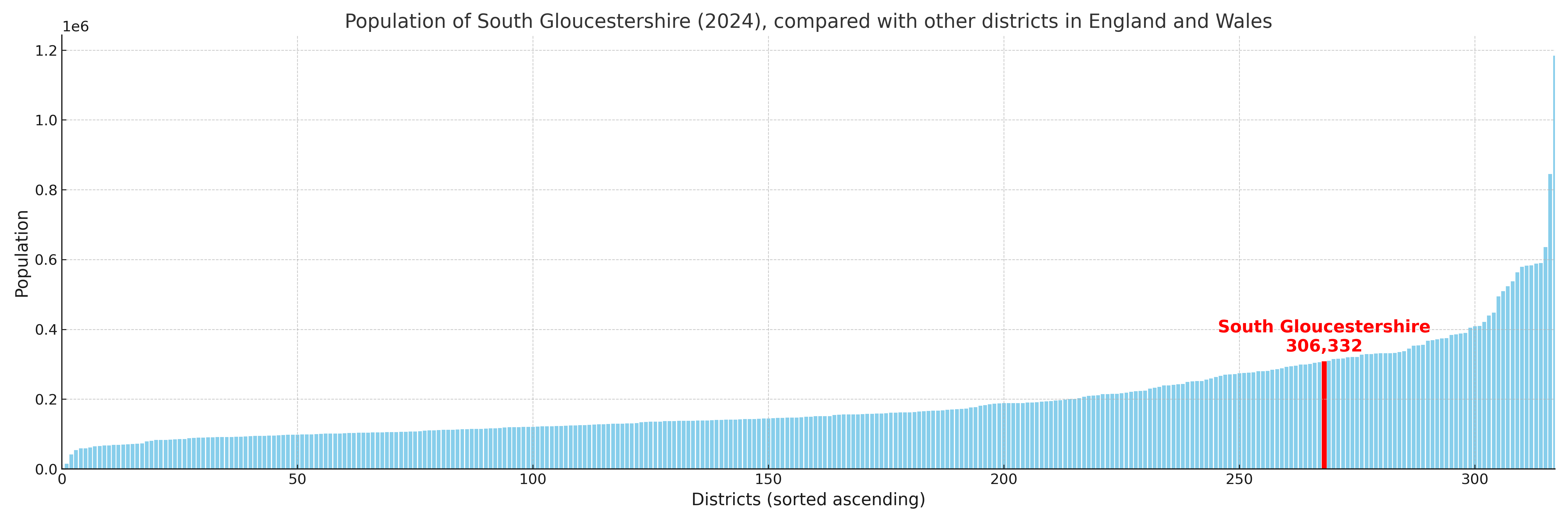
South Gloucestershire compared with other districts in the UK
This section shows how South Gloucestershire compares with other local authority districts in the UK, using a variety of measures and rankings.
South Gloucestershire has 28 electoral wards.

South Gloucestershire has a population of 306,332 (2024 mid-year estimate by ONS)
Population and Migration Trends in South Gloucestershire
This chart shows the population trend for South Gloucestershire from 2015 to 2024. It provides a quick overview of whether the local authority is growing, stable, or declining over time, and helps set context for the migration patterns shown below.
Population change is influenced by natural change (births minus deaths) and migration. The net migration chart below focuses on migration, separating internal migration (moves within the UK) from international migration (moves to and from abroad). Positive values indicate net inflows, while negative values indicate net outflows. The rate labels (per 1,000 residents) help compare migration intensity across years, even when the population size changes.
More local statistics and data for South Gloucestershire can be found on the ONS statistics for South Gloucestershire.
Latest news about South Gloucestershire
Use the search box, or suggested search phrases, below to find recent news, council updates, planning stories, housing developments, transport changes, public services news, local elections, community issues and other local developments related to South Gloucestershire. Results may include coverage from UK national, regional and local news websites, as well as official public-sector and local democracy sources.
- South Gloucestershire council
- South Gloucestershire planning
- South Gloucestershire local elections
- South Gloucestershire housing
- South Gloucestershire transport
- South Gloucestershire regeneration
- South Gloucestershire public services