Birmingham
§ This page gives an overview of the Birmingham local authority district, bringing together key facts, maps, and data to help you quickly understand the area. This is one of 361 LAD profiles on Baseview.
Overview ⁞ Birmingham, England’s second city, sits at the heart of the West Midlands and is known for its canals, cultural landmarks, and diverse neighbourhoods. The city centre features modern landmarks such as the Bullring, Library of Birmingham, and Symphony Hall, alongside historic buildings like Birmingham Town Hall and St Philip’s Cathedral. The extensive canal network, once central to industry, now offers leisure and waterfront regeneration. Parks and green spaces, including Sutton Park, one of the largest urban parks in Europe, balance the urban setting. Birmingham’s suburbs range from historic areas like Jewellery Quarter to leafy Edgbaston, creating a varied cityscape.
Birmingham Boundary Map
This map shows the official boundary of the Birmingham local authority district, based on the latest geographic data published by the Office for National Statistics (ONS). It provides a clear view of the district’s extent and helps you understand how the area fits within the wider regional and national landscape.
Contains OS data © Crown copyright and database right 2025. Source: Office for National Statistics licensed under the Open Government Licence v3.0.
The administrative boundary of Birmingham can also be viewed on OpenStreetMap: District Boundary of Birmingham.
Key Facts about Birmingham
What region is Birmingham in? Birmingham is in the West Midlands of England, a region within the UK.
What county is Birmingham in? Birmingham is located in the county of West Midlands.
Is Birmingham a city? Yes, Birmingham is a city. Birmingham holds official city status as one of the 76 designated cities in the UK.
Who governs Birmingham? The local government for this district is: Birmingham City Council (Metropolitan District).
▶ Official website of Birmingham City Council 🔗 birmingham.gov.uk
Which police force covers Birmingham? Policing in Birmingham is provided by West Midlands Police 🔗 west-midlands.police.uk, which serves 7 local authority districts: Birmingham ⁞ Coventry ⁞ Dudley ⁞ Sandwell ⁞ Solihull ⁞ Walsall ⁞ Wolverhampton.
Birmingham in International Geographies
In the International Territorial Levels (ITLs) hierarchy, Birmingham is an ITLs Level 3 area:
- (ITL 1) West Midlands
- (ITL 2) ⇒ West Midlands
- (ITL 3) ⇒⇒ Birmingham
The International Territorial Levels are used by OECD member countries for statistical purposes to classify administrative areas. We have this listable page for easy browsing of ITL names and codes: International Territorial Levels.
Constituencies in Birmingham
Birmingham is divided into 10 parliamentary constituencies, listed below in alphabetical order.
- Birmingham Edgbaston
- Birmingham Erdington
- Birmingham Hall Green and Moseley
- Birmingham Hodge Hill and Solihull North
- Birmingham Ladywood
- Birmingham Northfield
- Birmingham Perry Barr
- Birmingham Selly Oak
- Birmingham Yardley
- Sutton Coldfield
A constituency is a specific geographical area that elects one Member of Parliament (MP) to represent them in the House of Commons. The United Kingdom is divided into 650 parliamentary constituencies. We have this list page for easy browsing of all UK parliamentary constituencies: List of Constituencies.
Wards in Birmingham
Birmingham is divided into 69 wards, listed below in alphabetical order.
- Acocks Green
- Allens Cross
- Alum Rock
- Aston
- Balsall Heath West
- Bartley Green
- Billesley
- Birchfield
- Bordesley & Highgate
- Bordesley Green
- Bournbrook & Selly Park
- Bournville & Cotteridge
- Brandwood & King's Heath
- Bromford & Hodge Hill
- Castle Vale
- Druids Heath & Monyhull
- Edgbaston
- Erdington
- Frankley Great Park
- Garretts Green
- Glebe Farm & Tile Cross
- Gravelly Hill
- Hall Green North
- Hall Green South
- Handsworth
- Handsworth Wood
- Harborne
- Heartlands
- Highter's Heath
- Holyhead
- King's Norton North
- King's Norton South
- Kingstanding
- Ladywood
- Longbridge & West Heath
- Lozells
- Moseley
- Nechells
- Newtown
- North Edgbaston
- Northfield
- Oscott
- Perry Barr
- Perry Common
- Pype Hayes
- Quinton
- Rubery & Rednal
- Shard End
- Sheldon
- Small Heath
- Soho & Jewellery Quarter
- South Yardley
- Sparkbrook & Balsall Heath East
- Sparkhill
- Stirchley
- Stockland Green
- Sutton Four Oaks
- Sutton Mere Green
- Sutton Reddicap
- Sutton Roughley
- Sutton Trinity
- Sutton Vesey
- Sutton Walmley & Minworth
- Sutton Wylde Green
- Tyseley & Hay Mills
- Ward End
- Weoley & Selly Oak
- Yardley East
- Yardley West & Stechford
In the UK, a ward is a subdivision of a local authority area, used mainly for electoral and statistical purposes. Defined by the ONS, wards represent the primary unit for local elections, each returning one or more councillors to the local council. Wards are also used as a key geography for presenting population and census data. We have this list page for easy browsing of all electoral wards: List of all Electoral Wards in the UK.
Parishes in Birmingham
Birmingham is part-parished: 2 civil parishes (listed A-Z below) alongside 14 unparished areas.
- New Frankley in Birmingham
- Sutton Coldfield
A civil parish is the lowest tier of local government in England, used for villages, small towns, and suburbs. They have their own local authority, either a parish council or a parish meeting, which provides local services like managing parks, allotments, and streetlights, and represents the community's views to larger councils.
We have this list page for easy browsing of all parishes: List of Civil Parishes in England and Wales.
Post Towns in Birmingham
Below is a list of post towns in Birmingham, grouped by postcode area:
- B ▸ Birmingham (B1 / B2 / B3 / B4 / B5 / B6 / B7 / B8 / B9 / B10 / B11 / B12 / B13 / B14 / B15 / B16 / B17 / B18 / B19 / B20 / B21 / B23 / B24 / B25 / B26 / B27 / B28 / B29 / B30 / B31 / B32 / B33 / B34 / B35 / B36 / B37 / B38 / B40 / B42 / B43 / B44 / B45 / B46 / B47 / B48 / B99) ⁞ Sutton Coldfield (B72 / B73 / B74 / B75 / B76)
The UK postal hierarchy begins with broad postcode areas (such as “CB” or “M”), which are divided into smaller postcode districts (such as “CB8” or “M1”) to support accurate mail routing. Each postal address is anchored by a designated post town, the official locality name used in the UK postcode system, which operates independently from Local Authority Districts —the administrative boundaries used for council tax and local government services. Because they serve different purposes, a property’s postal address and its local authority district do not always align exactly.
Built-up Areas in Birmingham
Birmingham covers 11 built-up areas, listed below in alphabetical order.
- Birmingham *
- Curdworth *
- Halesowen *
- Oldbury (Sandwell) *
- Pheasey *
- Royal Sutton Coldfield *
- Smethwick *
- Solihull *
- Streetly *
- Water Orton *
- West Bromwich *
In the UK, a Built-up Area (BUA) is a continuous urban area of at least 20 hectares (0.2 km²), defined by the ONS as land where buildings are generally no more than 200 metres apart, such as towns, cities, or large villages. (Note: A BUA name marked with an asterisk (*) indicates that the area is situated partly in the district of Birmingham.)
We have this list page for easy browsing of all built-up areas: List of all Built-up Areas in GB.
Railway Stations in Birmingham
Birmingham is served by a number of National Rail stations, providing rail connections to nearby towns, cities, and destinations across Great Britain. The railway stations listed below are located within the Birmingham Local Authority District and are grouped by train operating company for clarity.
- Chiltern Railways ▸ Birmingham Moor Street (B4 7UL)
- Network Rail ▸ Birmingham New Street (B2 4QA)
- West Midlands Trains (West Midlands Railway) ▸ University (Birmingham) (B15 2FB) ⁞ Birmingham Snow Hill (B3 2BJ) ⁞ Selly Oak (B29 6DW) ⁞ Five Ways (B15 1SF) ⁞ Sutton Coldfield (B73 6AY) ⁞ Bournville (B30 1LG) ⁞ Kings Norton (B30 3EG) ⁞ Longbridge (B31 2TW) ⁞ Four Oaks (B74 2TD) ⁞ Chester Road (B73 5JS) ⁞ Northfield (B31 2PY) ⁞ Aston (B6 7PR) ⁞ Wylde Green (B73 5LA) ⁞ Erdington (B23 6UB) ⁞ Jewellery Quarter (B18 6LE) ⁞ Lea Hall (B33 8JU) ⁞ Acocks Green (B27 6EB) ⁞ Stechford (B33 8AJ) ⁞ Yardley Wood (B28 0BY) ⁞ Gravelly Hill (B23 7NH) ⁞ Blake Street (B74 4EB) ⁞ Witton (West Midlands) (B6 7BA) ⁞ Duddeston (B7 4ST) ⁞ Hall Green (B28 8AA) ⁞ Tyseley (B11 2HH) ⁞ Hamstead (Birmingham) (B42 1NJ) ⁞ Small Heath (B10 0DP) ⁞ Butlers Lane (B74 4RT) ⁞ Perry Barr (B20 3JE) ⁞ Spring Road (B11 3DP) ⁞ Adderley Park (B9 4TG) ⁞ Bordesley (B9 4HF)
This is a district-level view only. For a complete list of all National Rail stations across Great Britain, see the UK National Rail Stations Directory.
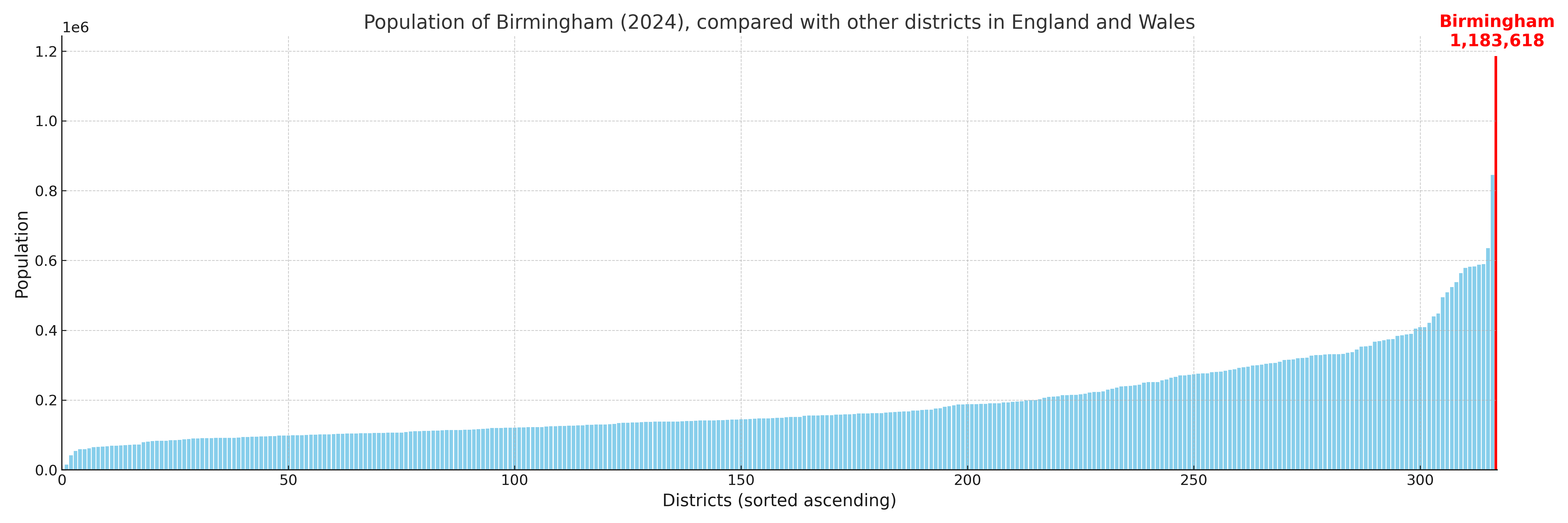
Birmingham compared with other districts in the UK
This section shows how Birmingham compares with other local authority districts in the UK, using a variety of measures and rankings.
Birmingham has 69 electoral wards.

Birmingham has a population of 1,183,618 (2024 mid-year estimate by ONS)
Population and Migration Trends in Birmingham
This chart shows the population trend for Birmingham from 2015 to 2024. It provides a quick overview of whether the local authority is growing, stable, or declining over time, and helps set context for the migration patterns shown below.
Population change is influenced by natural change (births minus deaths) and migration. The net migration chart below focuses on migration, separating internal migration (moves within the UK) from international migration (moves to and from abroad). Positive values indicate net inflows, while negative values indicate net outflows. The rate labels (per 1,000 residents) help compare migration intensity across years, even when the population size changes.
More local statistics and data for Birmingham can be found on the ONS statistics for Birmingham.
Latest news about Birmingham
Use the search box, or suggested search phrases, below to find recent news, council updates, planning stories, housing developments, transport changes, public services news, local elections, community issues and other local developments related to Birmingham. Results may include coverage from UK national, regional and local news websites, as well as official public-sector and local democracy sources.
- Birmingham council
- Birmingham planning
- Birmingham local elections
- Birmingham housing
- Birmingham transport
- Birmingham regeneration
- Birmingham public services