Stratford-on-Avon
§ This page gives an overview of the Stratford-on-Avon local authority district, bringing together key facts, maps, and data to help you quickly understand the area. This is one of 361 LAD profiles on Baseview.
Overview ⁞ Stratford-on-Avon district is dominated by the historic town of Stratford-upon-Avon, birthplace of William Shakespeare, with its timber-framed houses, theatres, and the River Avon. The district extends across a large rural area of south Warwickshire, with market towns like Alcester and Shipston-on-Stour, and picturesque villages in the Cotswolds and along the Avon Valley. The landscape includes rolling hills, rivers, woodlands, and agricultural land, dotted with castles, churches, and historic estates.
Stratford-on-Avon Boundary Map
This map shows the official boundary of the Stratford-on-Avon local authority district, based on the latest geographic data published by the Office for National Statistics (ONS). It provides a clear view of the district’s extent and helps you understand how the area fits within the wider regional and national landscape.
Contains OS data © Crown copyright and database right 2025. Source: Office for National Statistics licensed under the Open Government Licence v3.0.
The administrative boundary of Stratford-on-Avon can also be viewed on OpenStreetMap: District Boundary of Stratford-on-Avon.
Key Facts about Stratford-on-Avon
What region is Stratford-on-Avon in? Stratford-on-Avon is in the West Midlands of England, a region within the UK.
What county is Stratford-on-Avon in? Stratford-on-Avon is located in the county of Warwickshire.
Is Stratford-on-Avon a city? No, Stratford-on-Avon is not a city. (Note: the UK has 76 officially designated cities.)
Who governs Stratford-on-Avon? The local authority for this district is: Stratford on Avon District Council - responsible for district-level services. Since Warwickshire is a two-tier area, county-level services are handled by: Warwickshire County Council.
▶ Official website of Stratford on Avon District Council 🔗 stratford.gov.uk
Which police force covers Stratford-on-Avon? Policing in Stratford-on-Avon is provided by Warwickshire Police 🔗 warwickshire.police.uk, which serves 5 local authority districts: North Warwickshire ⁞ Nuneaton and Bedworth ⁞ Rugby ⁞ Stratford-on-Avon ⁞ Warwick.
Constituencies in Stratford-on-Avon
Stratford-on-Avon is divided into 2 parliamentary constituencies, listed below in alphabetical order.
A constituency is a specific geographical area that elects one Member of Parliament (MP) to represent them in the House of Commons. The United Kingdom is divided into 650 parliamentary constituencies. We have this list page for easy browsing of all UK parliamentary constituencies: List of Constituencies.
Wards in Stratford-on-Avon
Stratford-on-Avon is divided into 39 wards, listed below in alphabetical order.
- Alcester East
- Alcester West
- Bidford East
- Bidford West
- Bishop's Itchington, Fenny Compton & Napton
- Brailes & Compton
- Claverdon & Snitterfield
- Gaydon, Kineton & Upper Lighthorne
- Harbury
- Henley-in-Arden
- Kinwarton
- Long Marston
- Quinton
- Salford Priors & Alcester Rural
- Shipston North
- Shipston South
- Southam East, Central & Stockton
- Southam North & Long Itchington
- Southam South
- Southam West
- Stratford Avenue
- Stratford Bishopton
- Stratford Clopton
- Stratford Guildhall & Bridgetown
- Stratford Hathaway
- Stratford Orchard Hill
- Stratford Shottery
- Stratford Tiddington
- Stratford Welcombe
- Studley North
- Studley South
- Tanworth-in-Arden
- Tredington
- Tysoe
- Welford-on-Avon
- Wellesbourne East & Rural
- Wellesbourne North & Rural
- Wellesbourne South
- Wootton Wawen
In the UK, a ward is a subdivision of a local authority area, used mainly for electoral and statistical purposes. Defined by the ONS, wards represent the primary unit for local elections, each returning one or more councillors to the local council. Wards are also used as a key geography for presenting population and census data. We have this list page for easy browsing of all electoral wards: List of all Electoral Wards in the UK.
Parishes in Stratford-on-Avon
Stratford-on-Avon is fully parished: 113 civil parishes, listed A-Z below.
- Admington
- Alcester
- Alderminster
- Arrow with Weethley
- Aston Cantlow
- Atherstone on Stour
- Avon Dassett
- Barcheston
- Barton-on-the-Heath
- Bearley
- Beaudesert
- Bidford-on-Avon
- Billesley
- Binton
- Bishop's Itchington
- Brailes
- Burmington
- Burton Dassett
- Butlers Marston
- Chadshunt
- Chapel Ascote
- Charlecote
- Cherington
- Chesterton and Kingston
- Claverdon
- Clifford Chambers and Milcote
- Combrook
- Compton Verney
- Compton Wynyates
- Coughton
- Dorsington
- Ettington
- Exhall
- Farnborough
- Fenny Compton
- Fulbrook
- Gaydon
- Great Alne
- Great Wolford
- Halford
- Hampton Lucy
- Harbury
- Haselor
- Henley-in-Arden
- Hodnell and Wills Pastures
- Honington
- Idlicote
- Ilmington
- Kineton
- Kinwarton
- Ladbroke
- Langley
- Lighthorne
- Little Compton
- Little Wolford
- Long Compton
- Long Itchington
- Long Marston
- Loxley
- Luddington
- Mappleborough Green
- Moreton Morrell
- Morton Bagot
- Napton on the Hill
- Newbold Pacey
- Oldberrow
- Oxhill
- Pillerton Hersey
- Pillerton Priors
- Preston Bagot
- Preston on Stour
- Priors Hardwick
- Priors Marston
- Quinton
- Radbourn
- Radway
- Ratley and Upton
- Salford Priors
- Sambourne
- Shipston on Stour
- Shotteswell
- Snitterfield
- Southam
- Spernall
- Stockton
- Stoneton
- Stourton
- Stratford-upon-Avon
- Stretton-on-Fosse
- Studley
- Sutton-under-Brailes
- Tanworth-in-Arden
- Temple Grafton
- Tidmington
- Tredington
- Tysoe
- Ufton
- Ullenhall
- Upper and Lower Shuckburgh
- Upper Lighthorne
- Warmington
- Watergall
- Welford-on-Avon
- Wellesbourne and Walton
- Weston-on-Avon
- Whatcote
- Whichford
- Whitchurch
- Wilmcote
- Wixford
- Wolverton
- Wootton Wawen
- Wormleighton
A civil parish is the lowest tier of local government in England, used for villages, small towns, and suburbs. They have their own local authority, either a parish council or a parish meeting, which provides local services like managing parks, allotments, and streetlights, and represents the community's views to larger councils.
We have this list page for easy browsing of all parishes: List of Civil Parishes in England and Wales.
Post Towns in Stratford-on-Avon
Below is a list of post towns in Stratford-on-Avon, grouped by postcode area:
- B ▸ Alcester (B49 / B50) ⁞ Henley-in-Arden (B95) ⁞ Studley (B80)
- CV ▸ Shipston-on-Stour (CV36 / CV37) ⁞ Southam (CV47) ⁞ Stratford-upon-Avon (CV37)
The UK postal hierarchy begins with broad postcode areas (such as “CB” or “M”), which are divided into smaller postcode districts (such as “CB8” or “M1”) to support accurate mail routing. Each postal address is anchored by a designated post town, the official locality name used in the UK postcode system, which operates independently from Local Authority Districts —the administrative boundaries used for council tax and local government services. Because they serve different purposes, a property’s postal address and its local authority district do not always align exactly.
Built-up Areas in Stratford-on-Avon
Stratford-on-Avon covers 76 built-up areas, listed below in alphabetical order.
- Alcester
- Alderminster
- Ardens Grafton
- Armscote
- Ashorne *
- Aspley Heath *
- Astwood Bank *
- Bascote Heath *
- Bearley
- Bidford-on-Avon
- Binton
- Bishop's Itchington
- Broom (Stratford-on-Avon)
- Cherington and Stourton
- Chesterton Green
- Cladswell *
- Claverdon
- Clifford Chambers
- Earlswood *
- Ettington
- Fenny Compton
- Gaydon
- Great Alne
- Halford
- Harbury
- Henley-in-Arden
- Hockley Heath *
- Ilmington
- Kineton
- Kings Coughton
- Ladbroke
- Lighthorne
- Lighthorne Heath
- Long Compton
- Long Itchington
- Long Marston (Stratford-on-Avon)
- Lower Brailes
- Lower Quinton
- Mappleborough Green *
- Meon Vale *
- Moreton Morrell
- Napton on the Hill
- New End *
- Newbold-on-Stour
- Northend
- Norton Lindsey *
- Oxhill
- Pillerton Priors
- Priors Hardwick
- Priors Marston
- Radway
- Redditch *
- Salford Priors
- Sambourne
- Shipston-on-Stour
- Shotteswell
- Snitterfield
- Southam (Stratford-on-Avon)
- Stockton
- Stoneton *
- Stratford-upon-Avon
- Stretton-on-Fosse
- Studley
- Tanworth-in-Arden
- Temple Herdewyke
- Terry's Green
- Tiddington
- Tredington
- Ullenhall
- Upper Tysoe
- Warmington (Stratford-on-Avon)
- Welford-on-Avon
- Wellesbourne
- Wilmcote
- Wood End (Stratford-on-Avon)
- Wootton Wawen
In the UK, a Built-up Area (BUA) is a continuous urban area of at least 20 hectares (0.2 km²), defined by the ONS as land where buildings are generally no more than 200 metres apart, such as towns, cities, or large villages. (Note: A BUA name marked with an asterisk (*) indicates that the area is situated partly in the district of Stratford-on-Avon.)
We have this list page for easy browsing of all built-up areas: List of all Built-up Areas in GB.
Railway Stations in Stratford-on-Avon
Stratford-on-Avon is served by a number of National Rail stations, providing rail connections to nearby towns, cities, and destinations across Great Britain. The railway stations listed below are located within the Stratford-on-Avon Local Authority District and are grouped by train operating company for clarity.
- West Midlands Trains (West Midlands Railway) ▸ Stratford-Upon-Avon (CV37 6PL) ⁞ Stratford-upon-Avon Parkway (CV37 9QY) ⁞ Henley-In-Arden (B95 5JF) ⁞ Wilmcote (CV37 9UP) ⁞ Wootton Wawen (B95 6BJ) ⁞ The Lakes (Warks) (B94 5SE) ⁞ Wood End (B94 5DS) ⁞ Claverdon (CV35 8PE) ⁞ Danzey (B94 5BE) ⁞ Bearley (CV37 0EU)
This is a district-level view only. For a complete list of all National Rail stations across Great Britain, see the UK National Rail Stations Directory.
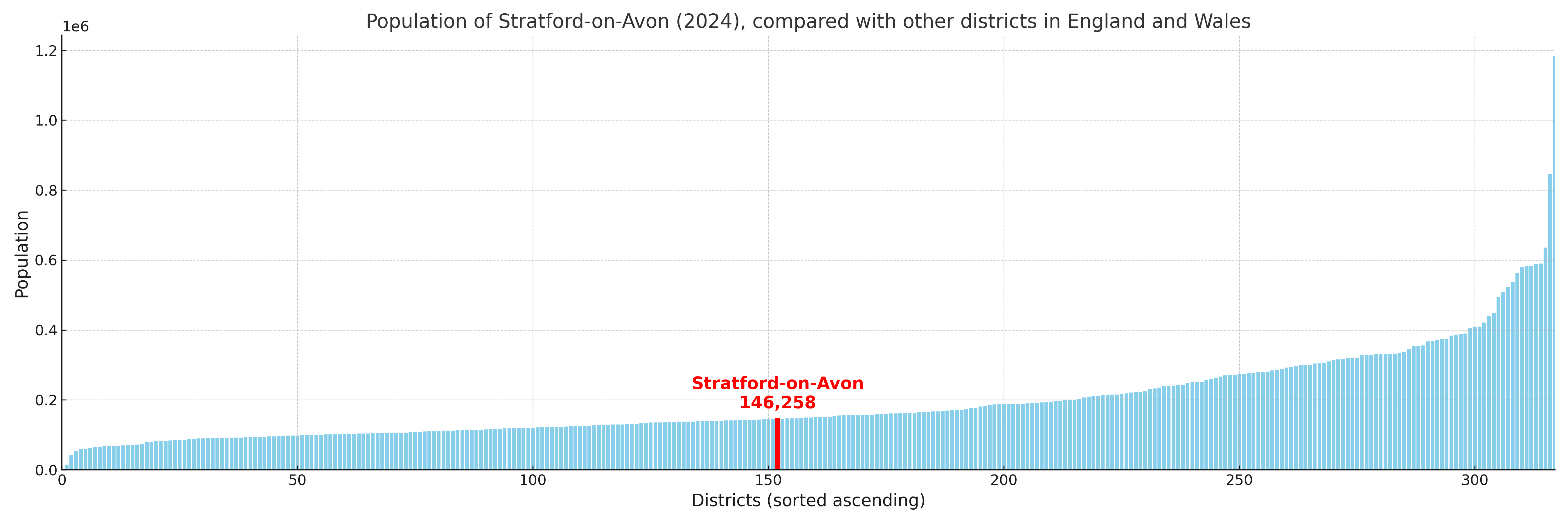
Stratford-on-Avon compared with other districts in the UK
This section shows how Stratford-on-Avon compares with other local authority districts in the UK, using a variety of measures and rankings.
Stratford-on-Avon has 39 electoral wards.

Stratford-on-Avon has a population of 146,258 (2024 mid-year estimate by ONS)
Population and Migration Trends in Stratford-on-Avon
This chart shows the population trend for Stratford-on-Avon from 2015 to 2024. It provides a quick overview of whether the local authority is growing, stable, or declining over time, and helps set context for the migration patterns shown below.
Population change is influenced by natural change (births minus deaths) and migration. The net migration chart below focuses on migration, separating internal migration (moves within the UK) from international migration (moves to and from abroad). Positive values indicate net inflows, while negative values indicate net outflows. The rate labels (per 1,000 residents) help compare migration intensity across years, even when the population size changes.
More local statistics and data for Stratford-on-Avon can be found on the ONS statistics for Stratford-on-Avon.
Latest news about Stratford-on-Avon
Use the search box, or suggested search phrases, below to find recent news, council updates, planning stories, housing developments, transport changes, public services news, local elections, community issues and other local developments related to Stratford-on-Avon. Results may include coverage from UK national, regional and local news websites, as well as official public-sector and local democracy sources.
- Stratford-on-Avon council
- Stratford-on-Avon planning
- Stratford-on-Avon local elections
- Stratford-on-Avon housing
- Stratford-on-Avon transport
- Stratford-on-Avon regeneration
- Stratford-on-Avon public services