Stoke-on-Trent
§ This page gives an overview of the Stoke-on-Trent local authority district, bringing together key facts, maps, and data to help you quickly understand the area. This is one of 361 LAD profiles on Baseview.
Overview ⁞ Stoke-on-Trent, in Staffordshire, is known as “The Potteries,” reflecting its world-famous ceramics industry. The city is made up of several towns including Hanley, Burslem, and Longton, each with its own identity. Attractions include the Potteries Museum and Art Gallery, Gladstone Pottery Museum, and canals lined with historic pottery works. The Trent and Mersey Canal runs through, while green spaces like Trentham Gardens and nearby moorland of the Staffordshire Moorlands add natural beauty. The district’s landscape is a mix of industrial heritage, waterways, and surrounding countryside.
What County is Stoke-on-Trent in?
Stoke-on-Trent is in the ceremonial county of Staffordshire, in the West Midlands region of England. Although it is often closely associated with nearby cities in the Midlands, Stoke-on-Trent is a unitary authority, meaning it manages its own local council services independently of Staffordshire County Council.
Historically, Stoke-on-Trent has always been part of Staffordshire and is world-famous as the heart of the English pottery industry, commonly known as “The Potteries.” So if you are asking “what county is Stoke-on-Trent in?”, the correct and widely accepted answer is Staffordshire, both historically and ceremonially.
Stoke-on-Trent Boundary Map
This map shows the official boundary of the Stoke-on-Trent local authority district, based on the latest geographic data published by the Office for National Statistics (ONS). It provides a clear view of the district’s extent and helps you understand how the area fits within the wider regional and national landscape.
Contains OS data © Crown copyright and database right 2025. Source: Office for National Statistics licensed under the Open Government Licence v3.0.
The administrative boundary of Stoke-on-Trent can also be viewed on OpenStreetMap: District Boundary of Stoke-on-Trent.
Key Facts about Stoke-on-Trent
What region is Stoke-on-Trent in? Stoke-on-Trent is in the West Midlands of England, a region within the UK.
What county is Stoke-on-Trent in? Stoke-on-Trent is in the county of Staffordshire.
Is Stoke-on-Trent a city? Yes, Stoke-on-Trent is a city. Stoke-on-Trent holds official city status as one of the 76 designated cities in the UK.
Who governs Stoke-on-Trent? The local government for this district is: Stoke-on-Trent City Council (Unitary Authority).
▶ Official website of Stoke-on-Trent City Council 🔗 stoke.gov.uk
Which police force covers Stoke-on-Trent? Policing in Stoke-on-Trent is provided by Staffordshire Police 🔗 staffordshire.police.uk, which serves 9 local authority districts: Cannock Chase ⁞ East Staffordshire ⁞ Lichfield ⁞ Newcastle-under-Lyme ⁞ South Staffordshire ⁞ Stafford ⁞ Staffordshire Moorlands ⁞ Stoke-on-Trent ⁞ Tamworth.
Stoke-on-Trent in International Geographies
In the International Territorial Levels (ITLs) hierarchy, Stoke-on-Trent is an ITLs Level 3 area:
- (ITL 1) West Midlands
- (ITL 2) ⇒ Shropshire and Staffordshire
- (ITL 3) ⇒⇒ Stoke-on-Trent
The International Territorial Levels are used by OECD member countries for statistical purposes to classify administrative areas. We have this listable page for easy browsing of ITL names and codes: International Territorial Levels.
Constituencies in Stoke-on-Trent
Stoke-on-Trent is divided into 3 parliamentary constituencies, listed below in alphabetical order.
A constituency is a specific geographical area that elects one Member of Parliament (MP) to represent them in the House of Commons. The United Kingdom is divided into 650 parliamentary constituencies. We have this list page for easy browsing of all UK parliamentary constituencies: List of Constituencies.
Wards in Stoke-on-Trent
Stoke-on-Trent is divided into 34 wards, listed below in alphabetical order.
- Abbey Hulton
- Baddeley, Milton & Norton
- Basford & Hartshill
- Bentilee, Ubberley & Townsend
- Birches Head & Northwood
- Blurton
- Boothen
- Bradeley & Chell Heath
- Bucknall & Eaton Park
- Burslem
- Burslem Park
- Dresden & Florence
- Etruria & Hanley
- Fenton East
- Fenton West & Mount Pleasant
- Ford Green & Smallthorne
- Goldenhill & Sandyford
- Great Chell & Packmoor
- Hanford, Newstead & Trentham
- Hanley Park, Joiner's Square & Shelton
- Hartshill Park & Stoke
- Hollybush
- Lightwood North & Normacot
- Little Chell & Stanfield
- Longton & Meir Hay South
- Meir Hay North, Parkhall & Weston Coyney
- Meir North
- Meir Park
- Meir South
- Moorcroft & Sneyd Green
- Penkhull & Springfields
- Sandford Hill
- Trent Vale & Oak Hill
- Tunstall
In the UK, a ward is a subdivision of a local authority area, used mainly for electoral and statistical purposes. Defined by the ONS, wards represent the primary unit for local elections, each returning one or more councillors to the local council. Wards are also used as a key geography for presenting population and census data. We have this list page for easy browsing of all electoral wards: List of all Electoral Wards in the UK.
Parishes in Stoke-on-Trent
Stoke-on-Trent is entirely unparished—there are no civil parishes in this local authority district.
Parishes are the lowest tier of local government; where they don’t exist, those very local services and representation sit directly with the principal council. We have this list page for easy browsing of all parishes: List of Civil Parishes in England and Wales.
Post Towns in Stoke-on-Trent
Below is a list of post towns in Stoke-on-Trent, grouped by postcode area:
ST ▸ Stoke-on-Trent (ST1 / ST2 / ST3 / ST4 / ST6 / ST7 / ST8 / ST9 / ST10 / ST11 / ST12)
The UK postal hierarchy begins with broad postcode areas (such as “CB” or “M”), which are divided into smaller postcode districts (such as “CB8” or “M1”) to support accurate mail routing. Each postal address is anchored by a designated post town, the official locality name used in the UK postcode system, which operates independently from Local Authority Districts —the administrative boundaries used for council tax and local government services. Because they serve different purposes, a property’s postal address and its local authority district do not always align exactly.
Built-up Areas in Stoke-on-Trent
Stoke-on-Trent covers 6 built-up areas, listed below in alphabetical order.
- Blythe Bridge and Forsbrook *
- Brown Edge *
- Harriseahead, Mow Cop and Newchapel *
- Newcastle-under-Lyme *
- Stoke-on-Trent *
- Werrington *
In the UK, a Built-up Area (BUA) is a continuous urban area of at least 20 hectares (0.2 km²), defined by the ONS as land where buildings are generally no more than 200 metres apart, such as towns, cities, or large villages. (Note: A BUA name marked with an asterisk (*) indicates that the area is situated partly in the district of Stoke-on-Trent.)
We have this list page for easy browsing of all built-up areas: List of all Built-up Areas in GB.
Railway Stations in Stoke-on-Trent
Stoke-on-Trent is served by a number of National Rail stations, providing rail connections to nearby towns, cities, and destinations across Great Britain. The railway stations listed below are located within the Stoke-on-Trent Local Authority District and are grouped by train operating company for clarity.
- Avanti West Coast ▸ Stoke-On-Trent (ST4 2AA)
- East Midlands Railway ▸ Longton (ST3 1EZ) ⁞ Longport (ST6 4ND)
This is a district-level view only. For a complete list of all National Rail stations across Great Britain, see the UK National Rail Stations Directory.
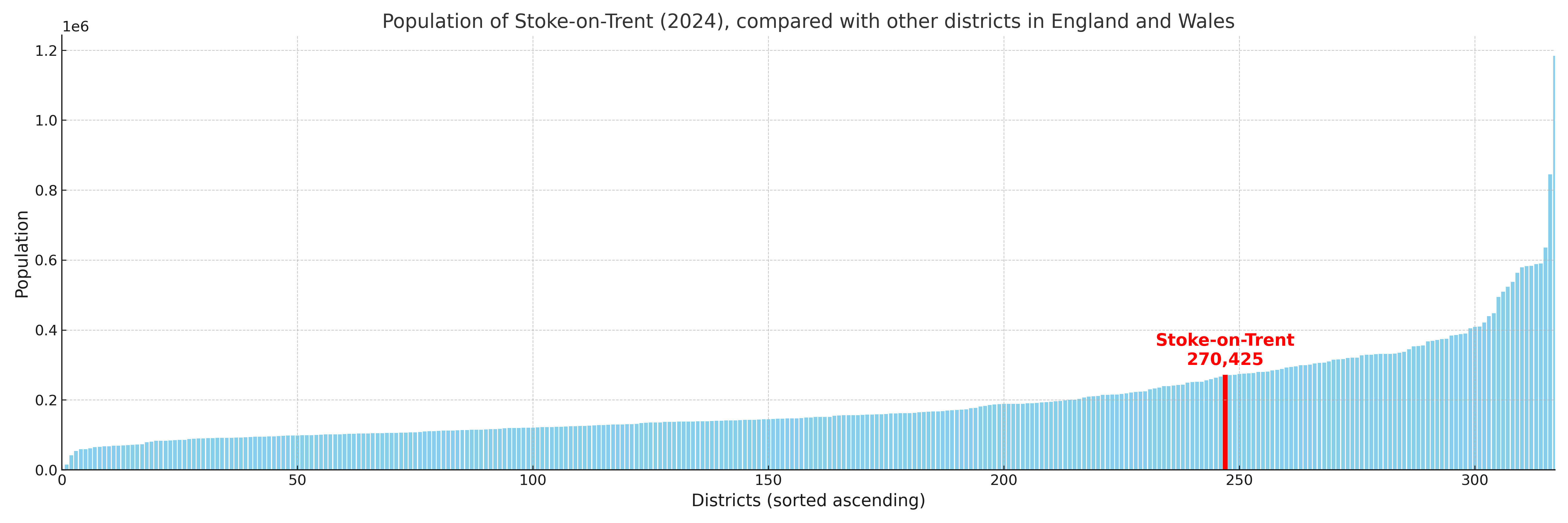
Stoke-on-Trent compared with other districts in the UK
This section shows how Stoke-on-Trent compares with other local authority districts in the UK, using a variety of measures and rankings.
Stoke-on-Trent has 34 electoral wards.

Stoke-on-Trent has a population of 270,425 (2024 mid-year estimate by ONS)
Population and Migration Trends in Stoke-on-Trent
This chart shows the population trend for Stoke-on-Trent from 2015 to 2024. It provides a quick overview of whether the local authority is growing, stable, or declining over time, and helps set context for the migration patterns shown below.
Population change is influenced by natural change (births minus deaths) and migration. The net migration chart below focuses on migration, separating internal migration (moves within the UK) from international migration (moves to and from abroad). Positive values indicate net inflows, while negative values indicate net outflows. The rate labels (per 1,000 residents) help compare migration intensity across years, even when the population size changes.
More local statistics and data for Stoke-on-Trent can be found on the ONS statistics for Stoke-on-Trent.
Latest news about Stoke-on-Trent
Use the search box, or suggested search phrases, below to find recent news, council updates, planning stories, housing developments, transport changes, public services news, local elections, community issues and other local developments related to Stoke-on-Trent. Results may include coverage from UK national, regional and local news websites, as well as official public-sector and local democracy sources.
- Stoke-on-Trent council
- Stoke-on-Trent planning
- Stoke-on-Trent local elections
- Stoke-on-Trent housing
- Stoke-on-Trent transport
- Stoke-on-Trent regeneration
- Stoke-on-Trent public services