Herefordshire, County of
§ This page gives an overview of the Herefordshire, County of local authority district, bringing together key facts, maps, and data to help you quickly understand the area. This is one of 361 LAD profiles on Baseview.
Overview ⁞ Herefordshire is a large rural county district along the Welsh border, known for its rolling countryside, orchards, and river valleys. Hereford, the main city, is famous for its cathedral, housing the Mappa Mundi and Chained Library. Market towns such as Leominster, Ledbury, and Ross-on-Wye add charm with timber-framed houses, medieval streets, and arts festivals. The River Wye meanders through the county, with the Wye Valley designated an Area of Outstanding Natural Beauty. Hills, forests, farmland, and scattered villages give Herefordshire a quintessentially rural character.
Herefordshire, County of Boundary Map
This map shows the official boundary of the Herefordshire, County of local authority district, based on the latest geographic data published by the Office for National Statistics (ONS). It provides a clear view of the district’s extent and helps you understand how the area fits within the wider regional and national landscape.
Contains OS data © Crown copyright and database right 2025. Source: Office for National Statistics licensed under the Open Government Licence v3.0.
The administrative boundary of Herefordshire, County of can also be viewed on OpenStreetMap: District Boundary of Herefordshire, County of.
Key Facts about Herefordshire, County of
What region is Herefordshire, County of in? Herefordshire, County of is in the West Midlands of England, a region within the UK.
What county is Herefordshire, County of in? Herefordshire, County of is in the county of Herefordshire.
Is Herefordshire, County of a city? Yes, Herefordshire, County of is a city. Herefordshire, County of holds official city status as one of the 76 designated cities in the UK.
Who governs Herefordshire, County of? The local government for this district is: Herefordshire Council (Unitary Authority).
▶ Official website of Herefordshire Council 🔗 herefordshire.gov.uk

Which police force covers Herefordshire, County of? Policing in Herefordshire, County of is provided by West Mercia Police 🔗 westmercia.police.uk, which serves 9 local authority districts: Bromsgrove ⁞ Herefordshire, County of ⁞ Malvern Hills ⁞ Redditch ⁞ Shropshire ⁞ Telford and Wrekin ⁞ Worcester ⁞ Wychavon ⁞ Wyre Forest.
Herefordshire, County of in International Geographies
In the International Territorial Levels (ITLs) hierarchy, Herefordshire, County of is an ITLs Level 3 area:
- (ITL 1) West Midlands
- (ITL 2) ⇒ Herefordshire, Worcestershire and Warwickshire
- (ITL 3) ⇒⇒ Herefordshire, County of
The International Territorial Levels are used by OECD member countries for statistical purposes to classify administrative areas. We have this listable page for easy browsing of ITL names and codes: International Territorial Levels.
Constituencies in Herefordshire, County of
Herefordshire, County of is divided into 2 parliamentary constituencies, listed below in alphabetical order.
A constituency is a specific geographical area that elects one Member of Parliament (MP) to represent them in the House of Commons. The United Kingdom is divided into 650 parliamentary constituencies. We have this list page for easy browsing of all UK parliamentary constituencies: List of Constituencies.
Wards in Herefordshire, County of
Herefordshire, County of is divided into 53 wards, listed below in alphabetical order.
- Arrow
- Aylestone Hill
- Backbury
- Belmont Rural
- Birch
- Bircher
- Bishops Frome & Cradley
- Bobblestock
- Bromyard Bringsty
- Bromyard West
- Castle
- Central
- College
- Credenhill
- Dinedor Hill
- Eign Hill
- Golden Valley North
- Golden Valley South
- Greyfriars
- Hagley
- Hampton
- Hinton & Hunderton
- Holmer
- Hope End
- Kerne Bridge
- Kings Acre
- Kington
- Ledbury North
- Ledbury South
- Ledbury West
- Leominster East
- Leominster North & Rural
- Leominster South
- Leominster West
- Llangarron
- Mortimer
- Newton Farm
- Old Gore
- Penyard
- Queenswood
- Red Hill
- Ross East
- Ross North
- Ross West
- Saxon Gate
- Stoney Street
- Sutton Walls
- Three Crosses
- Tupsley
- Weobley
- Whitecross
- Widemarsh
- Wormside
In the UK, a ward is a subdivision of a local authority area, used mainly for electoral and statistical purposes. Defined by the ONS, wards represent the primary unit for local elections, each returning one or more councillors to the local council. Wards are also used as a key geography for presenting population and census data. We have this list page for easy browsing of all electoral wards: List of all Electoral Wards in the UK.
Parishes in Herefordshire, County of
Herefordshire, County of is fully parished: 235 civil parishes, listed A-Z below.
- Abbey Dore
- Aconbury
- Acton Beauchamp
- Adforton
- Allensmore
- Almeley
- Ashperton
- Aston Ingham
- Avenbury
- Aylton
- Aymestrey
- Bacton
- Ballingham
- Bartestree
- Belmont Rural
- Birley with Upper Hill
- Bishop's Frome
- Bishopstone
- Blakemere
- Bodenham
- Bolstone
- Bosbury
- Brampton Abbotts
- Brampton Bryan
- Bredenbury
- Bredwardine
- Breinton
- Bridge Sollers
- Bridstow
- Brilley
- Brimfield
- Brinsop and Wormsley
- Brobury with Monnington on Wye
- Brockhampton (Bromyard Bringsty Ward)
- Brockhampton (Old Gore Ward)
- Bromyard and Winslow
- Buckton and Coxall
- Burghill
- Burrington
- Byford
- Byton
- Callow
- Canon Frome
- Canon Pyon
- Castle Frome
- Clehonger
- Clifford
- Coddington
- Collington
- Colwall
- Combe
- Cradley and Storridge
- Craswall
- Credenhill
- Croft and Yarpole
- Cusop
- Dewsall
- Dilwyn
- Dinedor
- Dinmore
- Docklow and Hampton Wafer
- Donnington
- Dormington
- Dorstone
- Downton
- Dulas
- Eardisland
- Eardisley
- Eastnor
- Eaton Bishop
- Edvin Loach and Saltmarshe
- Edwyn Ralph
- Eggleton
- Elton
- Evesbatch
- Ewyas Harold
- Eye, Moreton and Ashton
- Eyton
- Felton
- Ford and Stoke Prior
- Fownhope
- Foy
- Ganarew
- Garway
- Goodrich
- Grafton
- Grendon Bishop
- Hampton Bishop
- Hampton Charles
- Harewood
- Hatfield and Newhampton
- Haywood
- Hentland
- Hereford
- Holme Lacy
- Holmer & Shelwick
- Hope Mansell
- Hope under Dinmore
- How Caple
- Humber
- Huntington
- Kenchester
- Kentchurch
- Kilpeck
- Kimbolton
- King's Pyon
- Kings Caple
- Kingsland
- Kingstone
- Kington
- Kington Rural
- Kinnersley
- Kinsham
- Knill
- Laysters
- Lea
- Ledbury
- Leinthall Starkes
- Leintwardine
- Leominster
- Letton
- Lingen
- Linton (Bromyard Bringsty Ward)
- Linton (Penyard Ward)
- Little Birch
- Little Cowarne
- Little Dewchurch
- Little Hereford
- Little Marcle
- Llancillo
- Llandinabo
- Llangarron
- Llanrothal
- Llanveynoe
- Llanwarne
- Longtown
- Lower Bullingham
- Lower Harpton
- Lucton
- Lugwardine
- Luston
- Lyonshall
- Madley
- Mansell Gamage
- Mansell Lacy
- Marden
- Marstow
- Mathon
- Michaelchurch Escley
- Middleton on the Hill
- Moccas
- Monkland and Stretford
- Mordiford
- Moreton Jeffries
- Moreton on Lugg
- Much Birch
- Much Cowarne
- Much Dewchurch
- Much Marcle
- Munsley
- Newton (Golden Valley South Ward)
- Newton (Queenswood Ward)
- Norton
- Norton Canon
- Ocle Pychard
- Orcop
- Orleton
- Pembridge
- Pencombe with Grendon Warren
- Pencoyd
- Peterchurch
- Peterstow
- Pipe and Lyde
- Pipe Aston
- Pixley
- Preston on Wye
- Preston Wynne
- Pudlestone
- Putley
- Richards Castle (Hereford)
- Rodd, Nash and Little Brampton
- Ross-on-Wye
- Rowlstone
- Sarnesfield
- Sellack
- Shobdon
- Sollers Hope
- St. Margarets
- St. Weonards
- Stanford Bishop
- Stapleton
- Staunton on Arrow
- Staunton on Wye
- Stoke Edith
- Stoke Lacy
- Stretton Grandison
- Stretton Sugwas
- Sutton
- Tarrington
- Tedstone Delamere
- Tedstone Wafer
- Thornbury
- Thruxton
- Titley
- Tretire with Michaelchurch
- Turnastone
- Tyberton
- Ullingswick
- Upper Sapey
- Upton Bishop
- Vowchurch
- Wacton
- Walford
- Walford, Letton and Newton
- Walterstone
- Wellington
- Wellington Heath
- Welsh Bicknor
- Welsh Newton
- Weobley
- Westhide
- Weston Beggard
- Weston under Penyard
- Whitbourne
- Whitchurch
- Whitney-on-Wye
- Wigmore
- Willersley and Winforton
- Willey
- Withington
- Wolferlow
- Woolhope
- Yarkhill
- Yatton
- Yazor
A civil parish is the lowest tier of local government in England, used for villages, small towns, and suburbs. They have their own local authority, either a parish council or a parish meeting, which provides local services like managing parks, allotments, and streetlights, and represents the community's views to larger councils.
We have this list page for easy browsing of all parishes: List of Civil Parishes in England and Wales.
Post Towns in Herefordshire, County of
Below is a list of post towns in Herefordshire, County of, grouped by postcode area:
- HR ▸ Bromyard (HR7) ⁞ Hereford (HR1 / HR2 / HR3 / HR4) ⁞ Kington (HR5) ⁞ Ledbury (HR8) ⁞ Leominster (HR6) ⁞ Ross-on-Wye (HR9)
The UK postal hierarchy begins with broad postcode areas (such as “CB” or “M”), which are divided into smaller postcode districts (such as “CB8” or “M1”) to support accurate mail routing. Each postal address is anchored by a designated post town, the official locality name used in the UK postcode system, which operates independently from Local Authority Districts —the administrative boundaries used for council tax and local government services. Because they serve different purposes, a property’s postal address and its local authority district do not always align exactly.
Built-up Areas in Herefordshire, County of
Herefordshire, County of covers 65 built-up areas, listed below in alphabetical order.
- Bartestree
- Bodenham
- Bosbury
- Brimfield *
- Bromyard
- Burghill
- Clehonger
- Clifford's Mesne *
- Colwall Stone
- Cradley
- Credenhill
- Dilwyn
- Dorstone
- Eardisland
- Eardisley
- Ewyas Harold
- Fownhope
- Gorsley Common *
- Great Malvern *
- Hampton Bishop
- Hay-on-Wye *
- Hereford
- Holme Lacy
- King's Acre
- King's Thorn
- Kingsland
- Kingstone (Herefordshire)
- Kington
- Lea (Herefordshire)
- Ledbury
- Leintwardine
- Leominster
- Llangrove
- Lucton
- Lugwardine
- Luston
- Lyonshall
- Madley
- Marden (Herefordshire)
- Moreton on Lugg
- Orleton
- Pembridge
- Peterchurch
- Pontrilas
- Presteigne *
- Ross-on-Wye
- Shobdon
- St Michaels *
- Stoke Prior (Herefordshire)
- Sutton St Nicholas
- Symonds Yat West *
- Tarrington
- Wellington (Herefordshire)
- Wellington Heath
- Wellington Marsh
- Weobley
- Westfield (Herefordshire)
- Westhope
- Weston under Penyard
- Whitchurch (Herefordshire)
- Wigmore
- Wilton and Bridstow
- Withington and White Stone
- Withington Marsh
- Yarpole
In the UK, a Built-up Area (BUA) is a continuous urban area of at least 20 hectares (0.2 km²), defined by the ONS as land where buildings are generally no more than 200 metres apart, such as towns, cities, or large villages. (Note: A BUA name marked with an asterisk (*) indicates that the area is situated partly in the district of Herefordshire, County of.)
We have this list page for easy browsing of all built-up areas: List of all Built-up Areas in GB.
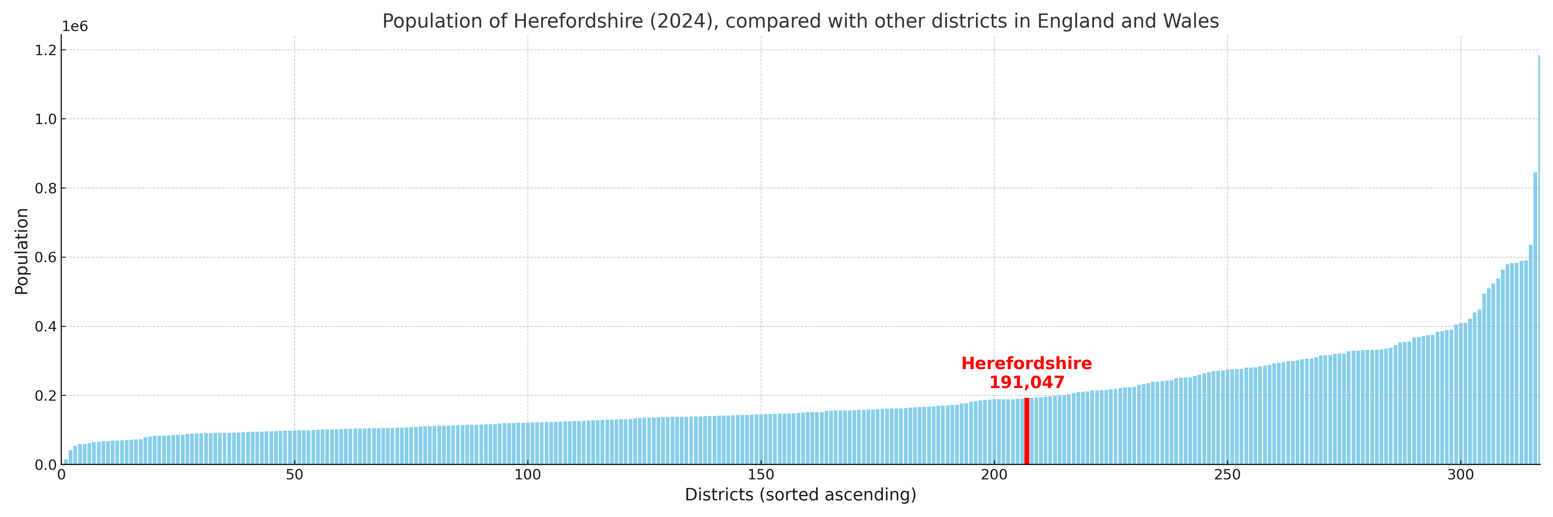
Herefordshire, County of compared with other districts in the UK
This section shows how Herefordshire, County of compares with other local authority districts in the UK, using a variety of measures and rankings.
Herefordshire, County of has 53 electoral wards.

Herefordshire, County of has a population of 191,047 (2024 mid-year estimate by ONS)
Population and Migration Trends in Herefordshire, County of
This chart shows the population trend for Herefordshire, County of from 2015 to 2024. It provides a quick overview of whether the local authority is growing, stable, or declining over time, and helps set context for the migration patterns shown below.
Population change is influenced by natural change (births minus deaths) and migration. The net migration chart below focuses on migration, separating internal migration (moves within the UK) from international migration (moves to and from abroad). Positive values indicate net inflows, while negative values indicate net outflows. The rate labels (per 1,000 residents) help compare migration intensity across years, even when the population size changes.
More local statistics and data for Herefordshire, County of can be found on the ONS statistics for Herefordshire, County of.
Latest news about Herefordshire, County of
Use the search box, or suggested search phrases, below to find recent news, council updates, planning stories, housing developments, transport changes, public services news, local elections, community issues and other local developments related to Herefordshire, County of. Results may include coverage from UK national, regional and local news websites, as well as official public-sector and local democracy sources.
- Herefordshire, County of council
- Herefordshire, County of planning
- Herefordshire, County of local elections
- Herefordshire, County of housing
- Herefordshire, County of transport
- Herefordshire, County of regeneration
- Herefordshire, County of public services