Rugby
§ This page gives an overview of the Rugby local authority district, bringing together key facts, maps, and data to help you quickly understand the area. This is one of 361 LAD profiles on Baseview.
Overview ⁞ Rugby, in eastern Warwickshire, is a market town famed worldwide as the birthplace of rugby football, celebrated at the Rugby School and museum. The town centre combines historic streets with modern shopping and cultural venues. The wider district includes villages, farmland, and the River Avon valley, with canals and reservoirs adding to its landscape. Its geography blends heritage, sports legacy, and rural charm.
What County is Rugby in?
Rugby is in the ceremonial county of Warwickshire, in the West Midlands region of England. It is administered by Rugby Borough Council, which operates within Warwickshire’s local government structure. For official, geographic, and ceremonial purposes, Rugby is recognised as being part of Warwickshire.
Historically, Rugby has long been associated with Warwickshire and has not been transferred to another county under modern local government reorganisations. Although it lies close to the boundaries of neighbouring counties such as Northamptonshire and Leicestershire, Rugby has remained in Warwickshire. The correct and current answer is that Rugby is in Warwickshire, both historically and today.
Rugby Boundary Map
This map shows the official boundary of the Rugby local authority district, based on the latest geographic data published by the Office for National Statistics (ONS). It provides a clear view of the district’s extent and helps you understand how the area fits within the wider regional and national landscape.
Contains OS data © Crown copyright and database right 2025. Source: Office for National Statistics licensed under the Open Government Licence v3.0.
The administrative boundary of Rugby can also be viewed on OpenStreetMap: District Boundary of Rugby.
Key Facts about Rugby
What region is Rugby in? Rugby is in the West Midlands of England, a region within the UK.
What county is Rugby in? Rugby is located in the county of Warwickshire.
Is Rugby a city? No, Rugby is not a city. (Note: the UK has 76 officially designated cities.)
Who governs Rugby? The local authority for this district is: Rugby Borough Council - responsible for district-level services. Since Warwickshire is a two-tier area, county-level services are handled by: Warwickshire County Council.
▶ Official website of Rugby Borough Council 🔗 rugby.gov.uk
Which police force covers Rugby? Policing in Rugby is provided by Warwickshire Police 🔗 warwickshire.police.uk, which serves 5 local authority districts: North Warwickshire ⁞ Nuneaton and Bedworth ⁞ Rugby ⁞ Stratford-on-Avon ⁞ Warwick.
Constituencies in Rugby
Rugby is divided into 2 parliamentary constituencies, listed below in alphabetical order.
A constituency is a specific geographical area that elects one Member of Parliament (MP) to represent them in the House of Commons. The United Kingdom is divided into 650 parliamentary constituencies. We have this list page for easy browsing of all UK parliamentary constituencies: List of Constituencies.
Wards in Rugby
Rugby is divided into 16 wards, listed below in alphabetical order.
- Admirals and Cawston
- Benn
- Bilton
- Clifton, Newton and Churchover
- Coton and Boughton
- Dunsmore
- Eastlands
- Hillmorton
- Leam Valley
- New Bilton
- Newbold and Brownsover
- Paddox
- Revel and Binley Woods
- Rokeby and Overslade
- Wolston and the Lawfords
- Wolvey and Shilton
In the UK, a ward is a subdivision of a local authority area, used mainly for electoral and statistical purposes. Defined by the ONS, wards represent the primary unit for local elections, each returning one or more councillors to the local council. Wards are also used as a key geography for presenting population and census data. We have this list page for easy browsing of all electoral wards: List of all Electoral Wards in the UK.
Parishes in Rugby
Rugby is part-parished: 41 civil parishes (listed A-Z below) alongside 2 unparished areas.
- Ansty
- Binley Woods
- Birdingbury
- Bourton and Draycote
- Brandon and Bretford
- Brinklow
- Burton Hastings
- Cawston
- Church Lawford
- Churchover
- Clifton upon Dunsmore
- Combe Fields
- Copston Magna
- Cosford
- Dunchurch
- Easenhall
- Frankton
- Grandborough
- Harborough Magna
- King's Newnham
- Leamington Hastings
- Little Lawford
- Long Lawford
- Marton
- Monks Kirby
- Newton and Biggin
- Pailton
- Princethorpe
- Ryton-on-Dunsmore
- Shilton and Barnacle
- Stretton Baskerville
- Stretton under Fosse
- Stretton-on-Dunsmore
- Thurlaston
- Wibtoft
- Willey
- Willoughby
- Withybrook
- Wolfhampcote
- Wolston
- Wolvey
A civil parish is the lowest tier of local government in England, used for villages, small towns, and suburbs. They have their own local authority, either a parish council or a parish meeting, which provides local services like managing parks, allotments, and streetlights, and represents the community's views to larger councils.
We have this list page for easy browsing of all parishes: List of Civil Parishes in England and Wales.
Post Towns in Rugby
Below is a list of post towns in Rugby, grouped by postcode area:
CV ▸ Rugby (CV21 / CV22 / CV23)
The UK postal hierarchy begins with broad postcode areas (such as “CB” or “M”), which are divided into smaller postcode districts (such as “CB8” or “M1”) to support accurate mail routing. Each postal address is anchored by a designated post town, the official locality name used in the UK postcode system, which operates independently from Local Authority Districts —the administrative boundaries used for council tax and local government services. Because they serve different purposes, a property’s postal address and its local authority district do not always align exactly.
Built-up Areas in Rugby
Rugby covers 26 built-up areas, listed below in alphabetical order.
- Barnacle
- Binley Woods
- Birdingbury
- Bramcote *
- Brinklow
- Cawston (Rugby)
- Clifton upon Dunsmore
- Coventry *
- Dunchurch
- Frankton
- Hinckley *
- Long Lawford
- Lutterworth *
- Marton (Rugby) *
- Monks Kirby
- Pailton
- Princethorpe
- Rugby *
- Ryton-on-Dunsmore
- Shilton
- Stretton under Fosse
- Stretton-on-Dunsmore
- Thurlaston (Rugby)
- Willoughby (Rugby)
- Wolston
- Wolvey
In the UK, a Built-up Area (BUA) is a continuous urban area of at least 20 hectares (0.2 km²), defined by the ONS as land where buildings are generally no more than 200 metres apart, such as towns, cities, or large villages. (Note: A BUA name marked with an asterisk (*) indicates that the area is situated partly in the district of Rugby.)
We have this list page for easy browsing of all built-up areas: List of all Built-up Areas in GB.
Railway Stations in Rugby
Rugby is served by a number of National Rail stations, providing rail connections to nearby towns, cities, and destinations across Great Britain. The railway stations listed below are located within the Rugby Local Authority District and are grouped by train operating company for clarity.
Avanti West Coast ▸ Rugby (CV21 3LA)
This is a district-level view only. For a complete list of all National Rail stations across Great Britain, see the UK National Rail Stations Directory.
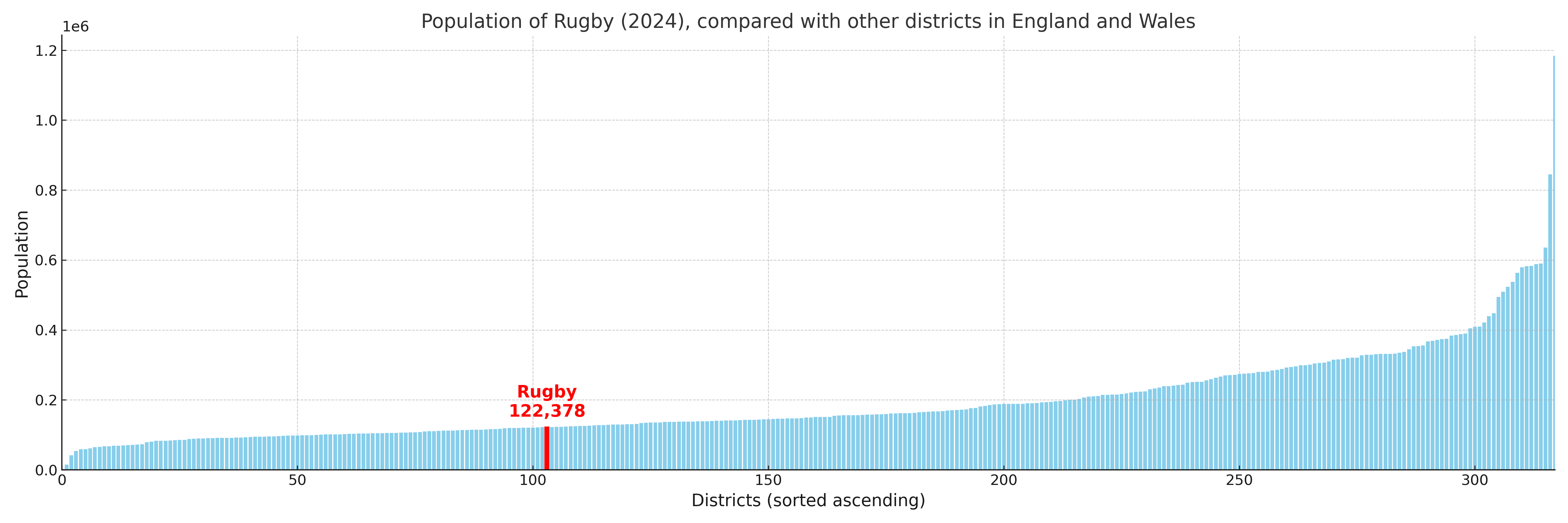
Rugby compared with other districts in the UK
This section shows how Rugby compares with other local authority districts in the UK, using a variety of measures and rankings.
Rugby has 16 electoral wards.

Rugby has a population of 122,378 (2024 mid-year estimate by ONS)
Population and Migration Trends in Rugby
This chart shows the population trend for Rugby from 2015 to 2024. It provides a quick overview of whether the local authority is growing, stable, or declining over time, and helps set context for the migration patterns shown below.
Population change is influenced by natural change (births minus deaths) and migration. The net migration chart below focuses on migration, separating internal migration (moves within the UK) from international migration (moves to and from abroad). Positive values indicate net inflows, while negative values indicate net outflows. The rate labels (per 1,000 residents) help compare migration intensity across years, even when the population size changes.
More local statistics and data for Rugby can be found on the ONS statistics for Rugby.
Latest news about Rugby
Use the search box, or suggested search phrases, below to find recent news, council updates, planning stories, housing developments, transport changes, public services news, local elections, community issues and other local developments related to Rugby. Results may include coverage from UK national, regional and local news websites, as well as official public-sector and local democracy sources.
- Rugby council
- Rugby planning
- Rugby local elections
- Rugby housing
- Rugby transport
- Rugby regeneration
- Rugby public services