Shropshire
§ This page gives an overview of the Shropshire local authority district, bringing together key facts, maps, and data to help you quickly understand the area. This is one of 361 LAD profiles on Baseview.
Overview ⁞ Shropshire is a largely rural and historic county on the border with Wales, known for its medieval market towns, castles, and the birthplace of the Industrial Revolution in Ironbridge Gorge, a UNESCO World Heritage Site. Key towns include Shrewsbury (the county town) and Telford, one of the UK’s largest new towns. The ceremonial county includes two unitary authorities: Shropshire Council and Telford and Wrekin Council, both operating independently but under the same ceremonial umbrella.
Shropshire Boundary Map
This map shows the official boundary of the Shropshire local authority district, based on the latest geographic data published by the Office for National Statistics (ONS). It provides a clear view of the district’s extent and helps you understand how the area fits within the wider regional and national landscape.
Contains OS data © Crown copyright and database right 2025. Source: Office for National Statistics licensed under the Open Government Licence v3.0.
The administrative boundary of Shropshire can also be viewed on OpenStreetMap: District Boundary of Shropshire.
Key Facts about Shropshire
What region is Shropshire in? Shropshire is in the West Midlands of England, a region within the UK.
What county is Shropshire in? Shropshire is in the county of Shropshire.
Is Shropshire a city? No, Shropshire is not a city. (Note: the UK has 76 officially designated cities.)
Who governs Shropshire? The local government for this district is: Shropshire Council (Unitary Authority).
▶ Official website of Shropshire Council 🔗 shropshire.gov.uk
Which police force covers Shropshire? Policing in Shropshire is provided by West Mercia Police 🔗 westmercia.police.uk, which serves 9 local authority districts: Bromsgrove ⁞ Herefordshire, County of ⁞ Malvern Hills ⁞ Redditch ⁞ Shropshire ⁞ Telford and Wrekin ⁞ Worcester ⁞ Wychavon ⁞ Wyre Forest.
Shropshire in International Geographies
In the International Territorial Levels (ITLs) hierarchy, Shropshire is within one of ITLs Level 2 area, Shropshire and Staffordshire, that contains the following 4 ITLs Level 3 areas:
(ITL 1) West Midlands
(ITL 2) ⇒ Shropshire and Staffordshire
(ITL 3) ⇒⇒ Telford and Wrekin ⁞ Shropshire ⁞ Stoke-on-Trent ⁞ Staffordshire CC
The International Territorial Levels are used by OECD member countries for statistical purposes to classify administrative areas. We have this listable page for easy browsing of ITL names and codes: International Territorial Levels.
Constituencies in Shropshire
Shropshire is divided into 4 parliamentary constituencies, listed below in alphabetical order.
A constituency is a specific geographical area that elects one Member of Parliament (MP) to represent them in the House of Commons. The United Kingdom is divided into 650 parliamentary constituencies. We have this list page for easy browsing of all UK parliamentary constituencies: List of Constituencies.
Wards in Shropshire
Shropshire is divided into 63 wards, listed below in alphabetical order.
- Abbey
- Albrighton
- Alveley and Claverley
- Bagley
- Battlefield
- Bayston Hill, Column and Sutton
- Belle Vue
- Bishop's Castle
- Bowbrook
- Bridgnorth East and Astley Abbotts
- Bridgnorth West and Tasley
- Broseley
- Brown Clee
- Burnell
- Castlefields and Ditherington
- Cheswardine
- Chirbury and Worthen
- Church Stretton and Craven Arms
- Clee
- Cleobury Mortimer
- Clun
- Copthorne
- Corvedale
- Ellesmere Urban
- Gobowen, Selattyn and Weston Rhyn
- Harlescott
- Highley
- Hodnet
- Llanymynech
- Longden
- Loton
- Ludlow East
- Ludlow North
- Ludlow South
- Market Drayton East
- Market Drayton West
- Meole
- Monkmoor
- Much Wenlock
- Oswestry East
- Oswestry South
- Oswestry West
- Porthill
- Prees
- Quarry and Coton Hill
- Radbrook
- Rea Valley
- Ruyton and Baschurch
- Severn Valley
- Shawbury
- Shifnal North
- Shifnal South and Cosford
- St Martin's
- St Oswald
- Sundorne
- Tern
- The Meres
- Underdale
- Wem
- Whitchurch North
- Whitchurch South
- Whittington
- Worfield
In the UK, a ward is a subdivision of a local authority area, used mainly for electoral and statistical purposes. Defined by the ONS, wards represent the primary unit for local elections, each returning one or more councillors to the local council. Wards are also used as a key geography for presenting population and census data. We have this list page for easy browsing of all electoral wards: List of all Electoral Wards in the UK.
Parishes in Shropshire
Shropshire is fully parished: 201 civil parishes, listed A-Z below.
- Abdon and Heath
- Acton Burnell
- Acton Round
- Acton Scott
- Adderley
- Alberbury with Cardeston
- Albrighton
- All Stretton
- Alveley
- Ashford Bowdler
- Ashford Carbonel
- Astley
- Astley Abbotts
- Aston Botterell
- Aston Eyre
- Atcham
- Badger
- Barrow
- Baschurch
- Bayston Hill
- Beckbury
- Bedstone
- Berrington
- Bettws-y-Crwyn
- Bicton
- Billingsley
- Bishop's Castle
- Bitterley
- Boningale
- Boraston
- Boscobel
- Bridgnorth
- Bromfield
- Broseley
- Bucknell
- Buildwas
- Burford
- Burwarton
- Cardington
- Caynham
- Chelmarsh
- Cheswardine
- Chetton
- Child's Ercall
- Chirbury with Brompton
- Church Preen
- Church Pulverbatch
- Church Stretton
- Claverley
- Clee St. Margaret
- Cleobury Mortimer
- Cleobury North
- Clive
- Clun
- Clunbury
- Clungunford
- Cockshutt
- Colebatch
- Condover
- Coreley
- Cound
- Craven Arms
- Cressage
- Culmington
- Deuxhill
- Diddlebury
- Ditton Priors
- Donington
- Eardington
- Easthope
- Eaton-under-Heywood
- Edgton
- Ellesmere Rural
- Ellesmere Urban
- Farlow
- Ford
- Frodesley
- Glazeley
- Great Hanwood
- Great Ness
- Greete
- Grinshill
- Hadnall
- Harley
- Highley
- Hinstock
- Hodnet
- Hope Bagot
- Hope Bowdler
- Hopesay
- Hopton Cangeford
- Hopton Castle
- Hopton Wafers
- Hordley
- Hughley
- Ightfield
- Kemberton
- Kenley
- Kinlet
- Kinnerley
- Knockin
- Leebotwood
- Leighton and Eaton Constantine
- Little Ness
- Llanfair Waterdine
- Llanyblodwel
- Llanymynech and Pant
- Longden
- Longnor
- Loppington
- Ludford
- Ludlow
- Lydbury North
- Lydham
- Mainstone
- Market Drayton
- Melverley
- Middleton Scriven
- Milson
- Minsterley
- Monkhopton
- Montford
- More
- Moreton Corbet and Lee Brockhurst
- Moreton Say
- Morville
- Much Wenlock
- Munslow
- Myddle, Broughton and Harmer Hill
- Myndtown
- Nash
- Neen Savage
- Neen Sollars
- Neenton
- Newcastle on Clun
- Norbury
- Norton in Hales
- Onibury
- Oswestry
- Oswestry Rural
- Petton
- Pimhill
- Pitchford
- Pontesbury
- Prees
- Quatt Malvern
- Ratlinghope
- Richard's Castle (Shropshire)
- Romsley
- Ruckley and Langley
- Rudge
- Rushbury
- Ruyton-XI-Towns
- Ryton
- Selattyn and Gobowen
- Shawbury
- Sheinton
- Sheriffhales
- Shifnal
- Shipton
- Shrewsbury
- Sibdon Carwood
- Sidbury
- Smethcott
- St. Martin's
- Stanton Lacy
- Stanton Long
- Stanton upon Hine Heath
- Stockton
- Stoke St. Milborough
- Stoke upon Tern
- Stottesdon
- Stowe
- Sutton Maddock
- Sutton upon Tern
- Tasley
- Tong
- Uffington
- Upton Cressett
- Upton Magna
- Welshampton and Lyneal
- Wem Rural
- Wem Urban
- Wentnor
- West Felton
- Westbury
- Weston Rhyn
- Weston-under-Redcastle
- Wheathill
- Whitchurch Rural
- Whitchurch Urban
- Whittington
- Whitton
- Whixall
- Wistanstow
- Withington
- Woolstaston
- Woore
- Worfield
- Worthen with Shelve
- Wroxeter and Uppington
A civil parish is the lowest tier of local government in England, used for villages, small towns, and suburbs. They have their own local authority, either a parish council or a parish meeting, which provides local services like managing parks, allotments, and streetlights, and represents the community's views to larger councils.
We have this list page for easy browsing of all parishes: List of Civil Parishes in England and Wales.
Post Towns in Shropshire
Below is a list of post towns in Shropshire, grouped by postcode area:
- SY ▸ Bishops Castle (SY9) ⁞ Bucknell (SY7) ⁞ Church Stretton (SY6) ⁞ Craven Arms (SY7) ⁞ Ellesmere (SY12) ⁞ Ludlow (SY8) ⁞ Lydbury North (SY7) ⁞ Oswestry (SY10 / SY11) ⁞ Shrewsbury (SY1 / SY2 / SY3 / SY4 / SY5 / SY99) ⁞ Whitchurch (SY13)
- TF ▸ Broseley (TF12) ⁞ Market Drayton (TF9) ⁞ Much Wenlock (TF13) ⁞ Shifnal (TF11)
- WV ▸ Bridgnorth (WV15 / WV16)
The UK postal hierarchy begins with broad postcode areas (such as “CB” or “M”), which are divided into smaller postcode districts (such as “CB8” or “M1”) to support accurate mail routing. Each postal address is anchored by a designated post town, the official locality name used in the UK postcode system, which operates independently from Local Authority Districts —the administrative boundaries used for council tax and local government services. Because they serve different purposes, a property’s postal address and its local authority district do not always align exactly.
Built-up Areas in Shropshire
Shropshire covers 102 built-up areas, listed below in alphabetical order.
- Ackleton
- Acton Burnell
- Albrighton
- All Stretton
- Alveley
- Ashford Carbonell
- Baschurch
- Bayston Hill
- Bedstone
- Bishop's Castle
- Bishops Wood *
- Bomere Heath
- Bridgnorth
- Brimfield *
- Broseley *
- Bucknell (Shropshire)
- Cheswardine
- Child's Ercall
- Chipnall
- Chirk Bank
- Church Stretton
- Churchstoke *
- Claverley
- Cleehill
- Cleobury Mortimer
- Clive
- Clun
- Cockshutt
- Condover
- Craven Arms
- Cressage
- Cross Houses
- Ditton Priors
- Doddington
- Dorrington (Shropshire)
- Dudleston Heath
- Easthope
- Ellesmere
- Ford
- Gobowen
- Gospel Ash *
- Hadnall
- Hanwood
- Harmer Hill
- Highley
- Hilton (Shropshire)
- Hinstock
- Hodnet
- Knighton *
- Knowbury
- Lem Hill *
- Little Ness
- Llanymynech *
- Longden
- Ludlow
- Lythbank
- Market Drayton *
- Minsterley
- Morda
- Much Wenlock
- Myddle
- Norton in Hales
- Oldbury (Shropshire)
- Oswestry
- Pant
- Pontesbury
- Prees
- Prees Higher Heath
- Quatford
- Rednal
- Rhoswiel
- Rockgreen
- Rosehill
- Ruyton-XI-Towns
- Shawbury
- Sheet (Shropshire)
- Sheriffhales
- Shifnal
- Shrewsbury
- Sleap
- Snailbeach
- St Martins
- Stanmore
- Telford *
- Tenbury Wells *
- Ternhill
- Tetchill
- Tibberton (Telford and Wrekin) *
- Tilstock
- Trefonen
- Walford
- Welshampton
- Wem
- West Felton
- Westbury (Shropshire)
- Weston Rhyn
- Whitchurch (Shropshire)
- Whittington (Shropshire)
- Wilcott
- Woore
- Worfield
- Worthen
In the UK, a Built-up Area (BUA) is a continuous urban area of at least 20 hectares (0.2 km²), defined by the ONS as land where buildings are generally no more than 200 metres apart, such as towns, cities, or large villages. (Note: A BUA name marked with an asterisk (*) indicates that the area is situated partly in the district of Shropshire.)
We have this list page for easy browsing of all built-up areas: List of all Built-up Areas in GB.
Railway Stations in Shropshire
Shropshire is served by a number of National Rail stations, providing rail connections to nearby towns, cities, and destinations across Great Britain. The railway stations listed below are located within the Shropshire Local Authority District and are grouped by train operating company for clarity.
- TfW Rail ▸ Shrewsbury (SY1 2DQ) ⁞ Ludlow (SY8 2PQ) ⁞ Gobowen (SY11 3JS) ⁞ Whitchurch (Shropshire) (SY13 1RL) ⁞ Church Stretton (SY6 6PG) ⁞ Wem (SY4 5AZ) ⁞ Craven Arms (SY7 9PY) ⁞ Prees (SY13 2DW) ⁞ Yorton (SY4 3EP) ⁞ Bucknell (SY7 0AD) ⁞ Hopton Heath (SY7 0QD) ⁞ Broome (SY7 0NT)
- West Midlands Trains (West Midlands Railway) ▸ Shifnal (TF11 9QB) ⁞ Albrighton (WV7 3DS) ⁞ Cosford (WV7 3EY)
This is a district-level view only. For a complete list of all National Rail stations across Great Britain, see the UK National Rail Stations Directory.
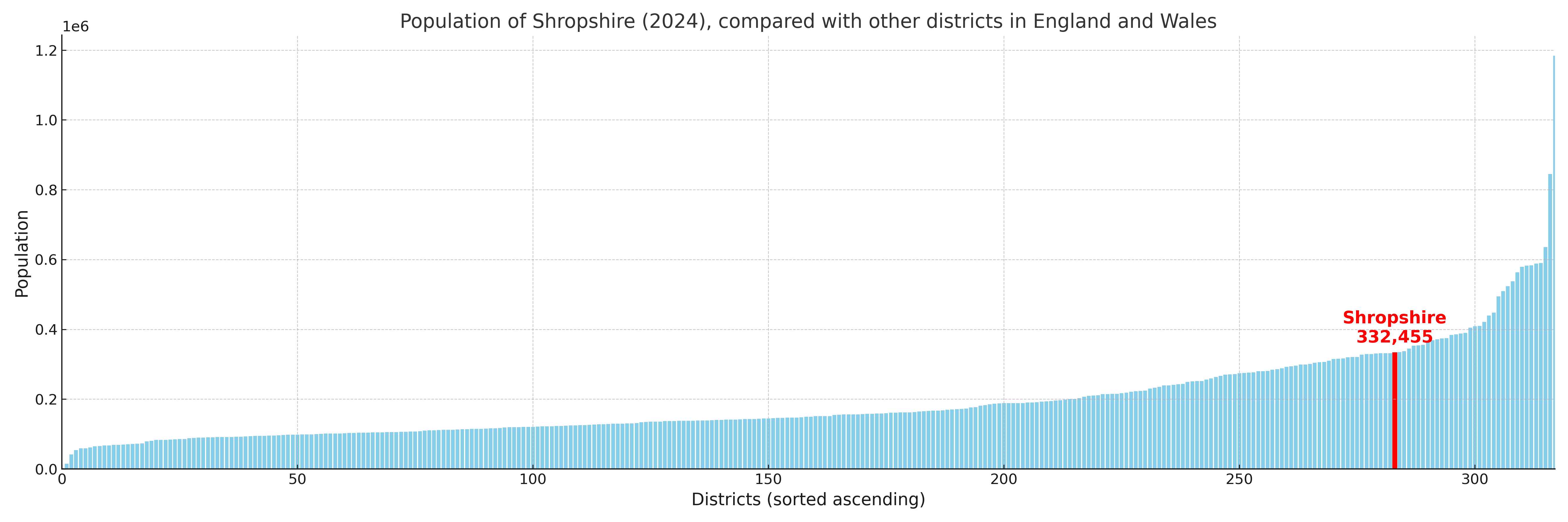
Shropshire compared with other districts in the UK
This section shows how Shropshire compares with other local authority districts in the UK, using a variety of measures and rankings.
Shropshire has 63 electoral wards.

Shropshire has a population of 332,455 (2024 mid-year estimate by ONS)
Population and Migration Trends in Shropshire
This chart shows the population trend for Shropshire from 2015 to 2024. It provides a quick overview of whether the local authority is growing, stable, or declining over time, and helps set context for the migration patterns shown below.
Population change is influenced by natural change (births minus deaths) and migration. The net migration chart below focuses on migration, separating internal migration (moves within the UK) from international migration (moves to and from abroad). Positive values indicate net inflows, while negative values indicate net outflows. The rate labels (per 1,000 residents) help compare migration intensity across years, even when the population size changes.
More local statistics and data for Shropshire can be found on the ONS statistics for Shropshire.
Latest news about Shropshire
Use the search box, or suggested search phrases, below to find recent news, council updates, planning stories, housing developments, transport changes, public services news, local elections, community issues and other local developments related to Shropshire. Results may include coverage from UK national, regional and local news websites, as well as official public-sector and local democracy sources.
- Shropshire council
- Shropshire planning
- Shropshire local elections
- Shropshire housing
- Shropshire transport
- Shropshire regeneration
- Shropshire public services