South Staffordshire
§ This page gives an overview of the South Staffordshire local authority district, bringing together key facts, maps, and data to help you quickly understand the area. This is one of 361 LAD profiles on Baseview.
Overview ⁞ South Staffordshire combines suburban towns, rural villages, and rolling countryside. Codsall, Wombourne, and Penkridge are key centres, while numerous villages preserve historic churches, cottages, and green spaces. The landscape features farmland, gentle hills, and wooded areas, with the Staffordshire and Worcestershire Canal adding scenic waterways. Its location between the urban West Midlands and Shropshire countryside gives it a balance of rural charm and commuter links.
South Staffordshire Boundary Map
This map shows the official boundary of the South Staffordshire local authority district, based on the latest geographic data published by the Office for National Statistics (ONS). It provides a clear view of the district’s extent and helps you understand how the area fits within the wider regional and national landscape.
Contains OS data © Crown copyright and database right 2025. Source: Office for National Statistics licensed under the Open Government Licence v3.0.
The administrative boundary of South Staffordshire can also be viewed on OpenStreetMap: District Boundary of South Staffordshire.
Key Facts about South Staffordshire
What region is South Staffordshire in? South Staffordshire is in the West Midlands of England, a region within the UK.
What county is South Staffordshire in? South Staffordshire is located in the county of Staffordshire.
Is South Staffordshire a city? No, South Staffordshire is not a city. (Note: the UK has 76 officially designated cities.)
Who governs South Staffordshire? The local authority for this district is: South Staffordshire District Council - responsible for district-level services. Since Staffordshire is a two-tier area, county-level services are handled by: Staffordshire County Council.
▶ Official website of South Staffordshire District Council 🔗 sstaffs.gov.uk
Which police force covers South Staffordshire? Policing in South Staffordshire is provided by Staffordshire Police 🔗 staffordshire.police.uk, which serves 9 local authority districts: Cannock Chase ⁞ East Staffordshire ⁞ Lichfield ⁞ Newcastle-under-Lyme ⁞ South Staffordshire ⁞ Stafford ⁞ Staffordshire Moorlands ⁞ Stoke-on-Trent ⁞ Tamworth.
Constituencies in South Staffordshire
South Staffordshire is divided into 2 parliamentary constituencies, listed below in alphabetical order.
A constituency is a specific geographical area that elects one Member of Parliament (MP) to represent them in the House of Commons. The United Kingdom is divided into 650 parliamentary constituencies. We have this list page for easy browsing of all UK parliamentary constituencies: List of Constituencies.
Wards in South Staffordshire
South Staffordshire is divided into 20 wards, listed below in alphabetical order.
- Bilbrook
- Brewood, Coven & Blymhill
- Cheslyn Hay Village
- Codsall
- Essington
- Featherstone, Sharehill & Saredon
- Great Wyrley Landywood
- Great Wyrley Town
- Himley & Swindon
- Huntington & Hatherton
- Kinver & Enville
- Lapley, Stretton & Wheaton Aston
- Pattingham, Trysull, Bobbington & Lower Penn
- Penkridge North & Acton Trussell
- Penkridge South & Gailey
- Perton East
- Perton Lakeside
- Perton Wrottesley
- Wombourne North
- Wombourne South
In the UK, a ward is a subdivision of a local authority area, used mainly for electoral and statistical purposes. Defined by the ONS, wards represent the primary unit for local elections, each returning one or more councillors to the local council. Wards are also used as a key geography for presenting population and census data. We have this list page for easy browsing of all electoral wards: List of all Electoral Wards in the UK.
Parishes in South Staffordshire
South Staffordshire is fully parished: 29 civil parishes, listed A-Z below.
- Acton Trussell and Bednall
- Bilbrook
- Blymhill and Weston-under-Lizard
- Bobbington
- Brewood and Coven
- Cheslyn Hay
- Codsall
- Coppenhall
- Dunston
- Enville
- Essington
- Featherstone
- Great Wyrley
- Hatherton
- Hilton
- Himley
- Huntington
- Kinver
- Lapley, Stretton and Wheaton Aston
- Lower Penn
- Pattingham and Patshull
- Penkridge
- Perton
- Saredon
- Shareshill
- Swindon
- Teddesley Hay
- Trysull and Seisdon
- Wombourne
A civil parish is the lowest tier of local government in England, used for villages, small towns, and suburbs. They have their own local authority, either a parish council or a parish meeting, which provides local services like managing parks, allotments, and streetlights, and represents the community's views to larger councils.
We have this list page for easy browsing of all parishes: List of Civil Parishes in England and Wales.
Built-up Areas in South Staffordshire
South Staffordshire covers 39 built-up areas, listed below in alphabetical order.
- Acton Trussell
- Bishops Wood *
- Bloxwich *
- Brewood
- Calf Heath
- Cannock *
- Codsall
- Coven
- Essington *
- Featherstone (South Staffordshire)
- Four Ashes
- Four Crosses (South Staffordshire)
- Gospel Ash *
- Gospel End
- Great Wyrley and Cheslyn Hay *
- Himley
- Huntington (South Staffordshire) *
- Hyde Lea and Coppenhall *
- Kingswinford *
- Kinver
- New Wood *
- Old Perton
- Pattingham
- Penkridge
- Perton *
- Rodbaston
- Sedgley *
- Seisdon
- Shareshill
- Springhill
- Stafford *
- Stourbridge *
- Stourton
- Swindon (South Staffordshire)
- Trysull
- Wheaton Aston
- Willenhall *
- Wolverhampton *
- Wombourne
In the UK, a Built-up Area (BUA) is a continuous urban area of at least 20 hectares (0.2 km²), defined by the ONS as land where buildings are generally no more than 200 metres apart, such as towns, cities, or large villages. (Note: A BUA name marked with an asterisk (*) indicates that the area is situated partly in the district of South Staffordshire.)
We have this list page for easy browsing of all built-up areas: List of all Built-up Areas in GB.
Railway Stations in South Staffordshire
South Staffordshire is served by a number of National Rail stations, providing rail connections to nearby towns, cities, and destinations across Great Britain. The railway stations listed below are located within the South Staffordshire Local Authority District and are grouped by train operating company for clarity.
- West Midlands Trains (West Midlands Railway) ▸ Penkridge (ST19 5AN) ⁞ Landywood (WS6 6JE) ⁞ Bilbrook (WV8 1LE) ⁞ Codsall (WV8 1BY)
This is a district-level view only. For a complete list of all National Rail stations across Great Britain, see the UK National Rail Stations Directory.
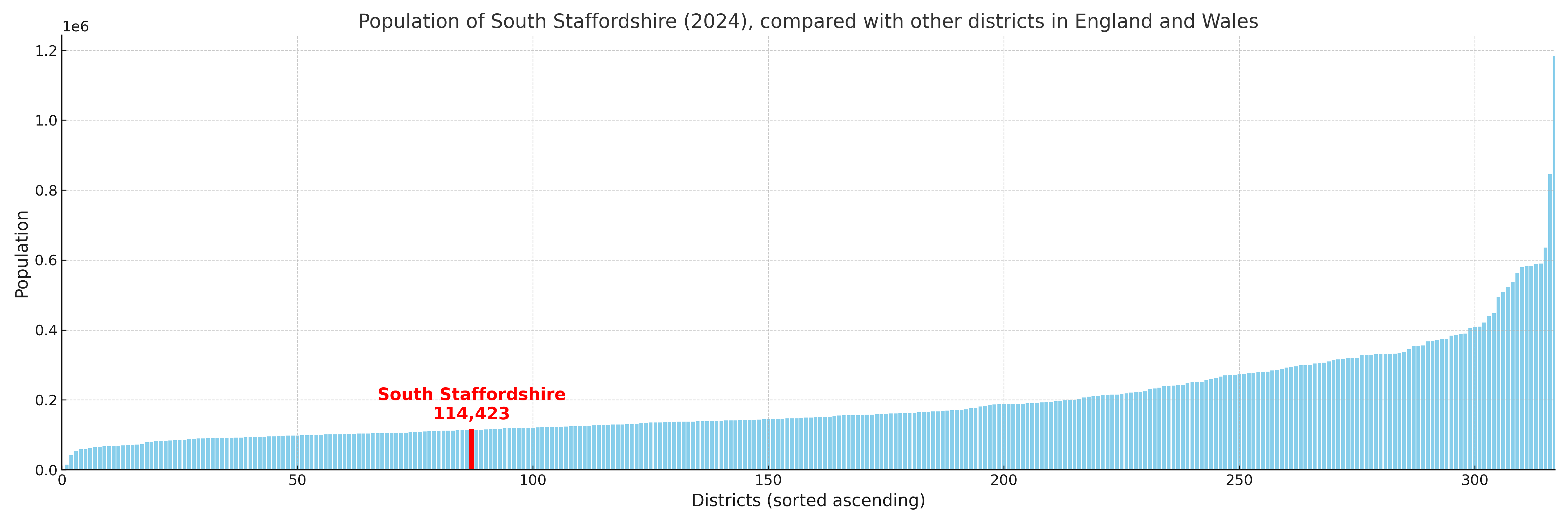
South Staffordshire compared with other districts in the UK
This section shows how South Staffordshire compares with other local authority districts in the UK, using a variety of measures and rankings.
South Staffordshire has 20 electoral wards.

South Staffordshire has a population of 114,423 (2024 mid-year estimate by ONS)
Population and Migration Trends in South Staffordshire
This chart shows the population trend for South Staffordshire from 2015 to 2024. It provides a quick overview of whether the local authority is growing, stable, or declining over time, and helps set context for the migration patterns shown below.
Population change is influenced by natural change (births minus deaths) and migration. The net migration chart below focuses on migration, separating internal migration (moves within the UK) from international migration (moves to and from abroad). Positive values indicate net inflows, while negative values indicate net outflows. The rate labels (per 1,000 residents) help compare migration intensity across years, even when the population size changes.
More local statistics and data for South Staffordshire can be found on the ONS statistics for South Staffordshire.
Latest news about South Staffordshire
Use the search box, or suggested search phrases, below to find recent news, council updates, planning stories, housing developments, transport changes, public services news, local elections, community issues and other local developments related to South Staffordshire. Results may include coverage from UK national, regional and local news websites, as well as official public-sector and local democracy sources.
- South Staffordshire council
- South Staffordshire planning
- South Staffordshire local elections
- South Staffordshire housing
- South Staffordshire transport
- South Staffordshire regeneration
- South Staffordshire public services