Malvern Hills
§ This page gives an overview of the Malvern Hills local authority district, bringing together key facts, maps, and data to help you quickly understand the area. This is one of 361 LAD profiles on Baseview.
Overview ⁞ Malvern Hills district is dominated by the dramatic ridge of the Malvern Hills, a designated Area of Outstanding Natural Beauty with sweeping views across Worcestershire and Herefordshire. Great Malvern, the main town, is known for its Victorian architecture, spa heritage, and theatre, while Upton-upon-Severn is a picturesque riverside town hosting festivals. Villages and farmland spread out into the Severn Valley and Teme Valley, with rivers, orchards, and woodlands defining the scenery. Its landscape is a mix of rugged hills, fertile plains, and historic settlements.
Malvern Hills Boundary Map
This map shows the official boundary of the Malvern Hills local authority district, based on the latest geographic data published by the Office for National Statistics (ONS). It provides a clear view of the district’s extent and helps you understand how the area fits within the wider regional and national landscape.
Contains OS data © Crown copyright and database right 2025. Source: Office for National Statistics licensed under the Open Government Licence v3.0.
The administrative boundary of Malvern Hills can also be viewed on OpenStreetMap: District Boundary of Malvern Hills.
Key Facts about Malvern Hills
What region is Malvern Hills in? Malvern Hills is in the West Midlands of England, a region within the UK.
What county is Malvern Hills in? Malvern Hills is located in the county of Worcestershire.
Is Malvern Hills a city? No, Malvern Hills is not a city. (Note: the UK has 76 officially designated cities.)
Who governs Malvern Hills? The local authority for this district is: Malvern Hills District Council - responsible for district-level services. Since Worcestershire is a two-tier area, county-level services are handled by: Worcestershire County Council.
▶ Official website of Malvern Hills District Council 🔗 malvernhills.gov.uk

Which police force covers Malvern Hills? Policing in Malvern Hills is provided by West Mercia Police 🔗 westmercia.police.uk, which serves 9 local authority districts: Bromsgrove ⁞ Herefordshire, County of ⁞ Malvern Hills ⁞ Redditch ⁞ Shropshire ⁞ Telford and Wrekin ⁞ Worcester ⁞ Wychavon ⁞ Wyre Forest.
Constituencies in Malvern Hills
Malvern Hills is divided into 1 parliamentary constituencies, listed below in alphabetical order.
A constituency is a specific geographical area that elects one Member of Parliament (MP) to represent them in the House of Commons. The United Kingdom is divided into 650 parliamentary constituencies. We have this list page for easy browsing of all UK parliamentary constituencies: List of Constituencies.
Wards in Malvern Hills
Malvern Hills is divided into 18 wards, listed below in alphabetical order.
- Alfrick, Leigh & Rushwick
- Baldwin
- Barnards Green
- Broadheath
- Castlemorton, Welland & Wells
- Great Malvern
- Hallow & Holt
- Kempsey
- Lindridge
- Link
- Longdon
- Martley
- Pickersleigh
- Powick & the Hanleys
- Tenbury
- Upper Howsell
- Upton & Ripple
- West
In the UK, a ward is a subdivision of a local authority area, used mainly for electoral and statistical purposes. Defined by the ONS, wards represent the primary unit for local elections, each returning one or more councillors to the local council. Wards are also used as a key geography for presenting population and census data. We have this list page for easy browsing of all electoral wards: List of all Electoral Wards in the UK.
Parishes in Malvern Hills
Malvern Hills is fully parished: 68 civil parishes, listed A-Z below.
- Abberley
- Alfrick
- Astley and Dunley
- Bayton
- Berrow
- Birtsmorton
- Bockleton
- Bransford
- Broadwas
- Bushley
- Castlemorton
- Clifton upon Teme
- Cotheridge
- Croome D'Abitot
- Doddenham
- Earl's Croome
- Eastham
- Eldersfield
- Great Witley
- Grimley
- Guarlford
- Hallow
- Hanley
- Hanley Castle
- Hill Croome
- Hillhampton
- Holdfast
- Holt
- Kempsey
- Kenswick
- Knighton on Teme
- Knightwick
- Kyre
- Leigh
- Lindridge
- Little Malvern
- Little Witley
- Longdon
- Lower Broadheath
- Lower Sapey
- Lulsley
- Madresfield
- Malvern
- Malvern Wells
- Mamble
- Martley
- Newland
- Pendock
- Pensax
- Powick
- Queenhill
- Ripple
- Rochford
- Rushwick
- Severn Stoke
- Shelsley Beauchamp
- Shelsley Kings
- Shelsley Walsh
- Shrawley
- Stanford with Orleton
- Stockton on Teme
- Stoke Bliss
- Suckley
- Tenbury
- Upton-upon-Severn
- Welland
- West Malvern
- Wichenford
A civil parish is the lowest tier of local government in England, used for villages, small towns, and suburbs. They have their own local authority, either a parish council or a parish meeting, which provides local services like managing parks, allotments, and streetlights, and represents the community's views to larger councils.
We have this list page for easy browsing of all parishes: List of Civil Parishes in England and Wales.
Post Towns in Malvern Hills
Below is a list of post towns in Malvern Hills, grouped by postcode area:
- WR ▸ Malvern (WR13 / WR14) ⁞ Tenbury Wells (WR15)
The UK postal hierarchy begins with broad postcode areas (such as “CB” or “M”), which are divided into smaller postcode districts (such as “CB8” or “M1”) to support accurate mail routing. Each postal address is anchored by a designated post town, the official locality name used in the UK postcode system, which operates independently from Local Authority Districts —the administrative boundaries used for council tax and local government services. Because they serve different purposes, a property’s postal address and its local authority district do not always align exactly.
Built-up Areas in Malvern Hills
Malvern Hills covers 32 built-up areas, listed below in alphabetical order.
- Abberley
- Besford *
- Bransford
- Broadwas
- Callow End
- Clifton upon Teme
- Clows Top *
- Collett's Green
- Eardiston
- Great Malvern *
- Great Witley
- Hallow
- Hanley Castle
- Hanley Swan
- Holt (Malvern Hills)
- Kempsey
- Leigh Sinton
- Lem Hill *
- Lower Broadheath
- Malvern Wells
- Martley
- Norton (Norton Juxta Kempsey) *
- Powick
- Queenhill
- Rushwick *
- Ryall
- St Michaels *
- Stourport-on-Severn *
- Tenbury Wells *
- Upton upon Severn
- Welland
- Worcester *
In the UK, a Built-up Area (BUA) is a continuous urban area of at least 20 hectares (0.2 km²), defined by the ONS as land where buildings are generally no more than 200 metres apart, such as towns, cities, or large villages. (Note: A BUA name marked with an asterisk (*) indicates that the area is situated partly in the district of Malvern Hills.)
We have this list page for easy browsing of all built-up areas: List of all Built-up Areas in GB.
Railway Stations in Malvern Hills
Malvern Hills is served by a number of National Rail stations, providing rail connections to nearby towns, cities, and destinations across Great Britain. The railway stations listed below are located within the Malvern Hills Local Authority District and are grouped by train operating company for clarity.
- West Midlands Trains (West Midlands Railway) ▸ Great Malvern (WR14 3AL) ⁞ Malvern Link (WR14 1SW)
This is a district-level view only. For a complete list of all National Rail stations across Great Britain, see the UK National Rail Stations Directory.
Malvern Hills compared with other districts in the UK
This section shows how Malvern Hills compares with other local authority districts in the UK, using a variety of measures and rankings.
Malvern Hills has 18 electoral wards.

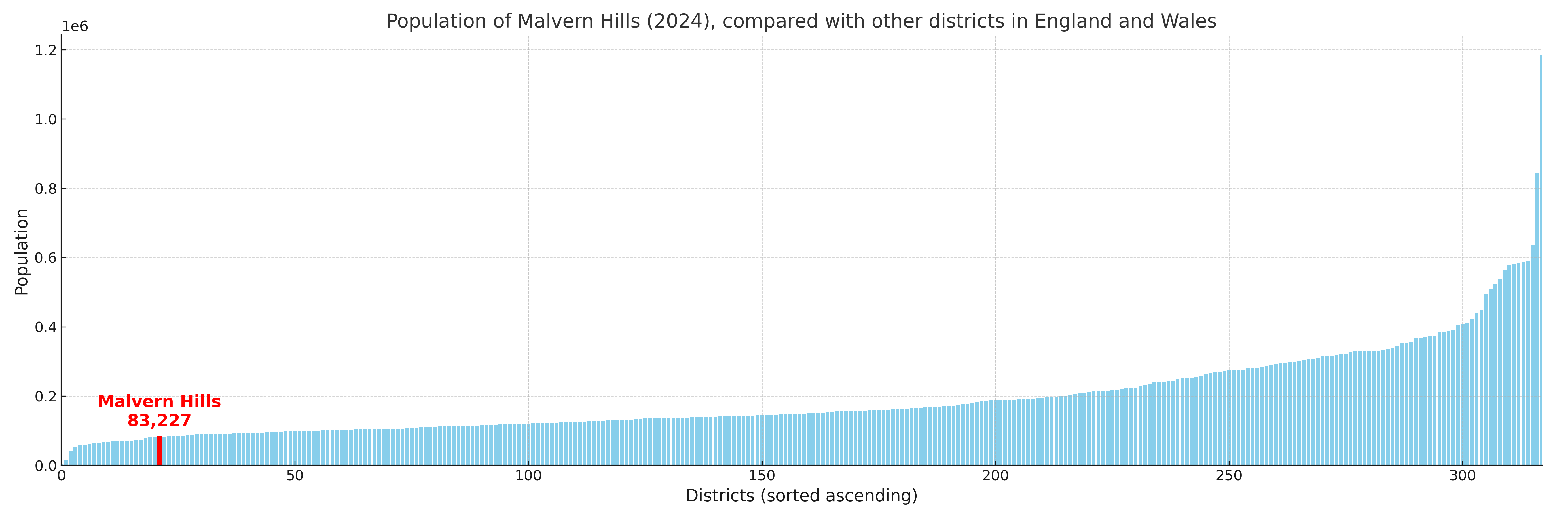
Malvern Hills has a population of 83,227 (2024 mid-year estimate by ONS)
Population and Migration Trends in Malvern Hills
This chart shows the population trend for Malvern Hills from 2015 to 2024. It provides a quick overview of whether the local authority is growing, stable, or declining over time, and helps set context for the migration patterns shown below.
Population change is influenced by natural change (births minus deaths) and migration. The net migration chart below focuses on migration, separating internal migration (moves within the UK) from international migration (moves to and from abroad). Positive values indicate net inflows, while negative values indicate net outflows. The rate labels (per 1,000 residents) help compare migration intensity across years, even when the population size changes.
More local statistics and data for Malvern Hills can be found on the ONS statistics for Malvern Hills.
Latest news about Malvern Hills
Use the search box, or suggested search phrases, below to find recent news, council updates, planning stories, housing developments, transport changes, public services news, local elections, community issues and other local developments related to Malvern Hills. Results may include coverage from UK national, regional and local news websites, as well as official public-sector and local democracy sources.
- Malvern Hills council
- Malvern Hills planning
- Malvern Hills local elections
- Malvern Hills housing
- Malvern Hills transport
- Malvern Hills regeneration
- Malvern Hills public services