Isle of Anglesey
§ This page gives an overview of the Isle of Anglesey local authority district, bringing together key facts, maps, and data to help you quickly understand the area. This is one of 361 LAD profiles on Baseview.
Overview ⁞ Isle of Anglesey (Ynys Môn) is an island off northwest Wales connected to the mainland by the Menai bridges. Known for its coastal scenery, ancient monuments, and port town of Holyhead, it relies on tourism, agriculture, and ferry links to Ireland.
Isle of Anglesey Boundary Map
This map shows the official boundary of the Isle of Anglesey local authority district, based on the latest geographic data published by the Office for National Statistics (ONS). It provides a clear view of the district’s extent and helps you understand how the area fits within the wider regional and national landscape.
Contains OS data © Crown copyright and database right 2025. Source: Office for National Statistics licensed under the Open Government Licence v3.0.
The administrative boundary of Isle of Anglesey can also be viewed on OpenStreetMap: District Boundary of Isle of Anglesey.
Key Facts about Isle of Anglesey
What region is Isle of Anglesey in? Isle of Anglesey is in Wales, a statistical region and also a country in United Kingdom.
Is Isle of Anglesey a city? No, Isle of Anglesey is not a city. (Note: the UK has 76 officially designated cities.)
Who governs Isle of Anglesey? The local government for this district is: Isle of Anglesey County Council (Wales County Council).
▶ Official website of Isle of Anglesey County Council 🔗 anglesey.gov.uk
Which police force covers Isle of Anglesey? Policing in Isle of Anglesey is provided by North Wales Police 🔗 northwales.police.uk, which serves 6 local authority districts: Conwy ⁞ Denbighshire ⁞ Flintshire ⁞ Gwynedd ⁞ Isle of Anglesey ⁞ Wrexham.
Isle of Anglesey in International Geographies
In the International Territorial Levels (ITLs) hierarchy, Isle of Anglesey is an ITLs Level 3 area:
- (ITL 1) Wales
- (ITL 2) ⇒ North Wales
- (ITL 3) ⇒⇒ Isle of Anglesey
The International Territorial Levels are used by OECD member countries for statistical purposes to classify administrative areas. We have this listable page for easy browsing of ITL names and codes: International Territorial Levels.
Constituencies in Isle of Anglesey
Isle of Anglesey is divided into 1 parliamentary constituencies, listed below in alphabetical order.
A constituency is a specific geographical area that elects one Member of Parliament (MP) to represent them in the House of Commons. The United Kingdom is divided into 650 parliamentary constituencies, 32 of them are in Wales. We have this list page for easy browsing of all UK parliamentary constituencies: List of Constituencies.
Wards in Isle of Anglesey
Isle of Anglesey is divided into 14 wards, listed below in alphabetical order.
- Aethwy
- Bodowyr
- Bro Aberffraw
- Bro'r Llynnoedd
- Canolbarth Môn
- Cefni
- Crigyll
- Lligwy
- Parc a'r Mynydd
- Seiriol
- Talybolion
- Tref Cybi
- Twrcelyn
- Ynys Gybi
In the UK, a ward is a subdivision of a local authority area, used mainly for electoral and statistical purposes. Defined by the ONS, wards represent the primary unit for local elections, each returning one or more councillors to the local council. Wards are also used as a key geography for presenting population and census data. We have this list page for easy browsing of all electoral wards: List of all Electoral Wards in the UK.
Communities in Isle of Anglesey
Isle of Anglesey has 40 communities, listed below in alphabetical order.
- Aberffraw
- Amlwch
- Beaumaris
- Bodedern
- Bodffordd
- Bodorgan
- Bryngwran
- Cwm Cadnant
- Cylch-y-Garn
- Holyhead
- Llanbadrig
- Llanddaniel Fab
- Llanddona
- Llanddyfnan
- Llaneilian
- Llaneugrad
- Llanfachraeth
- Llanfaelog
- Llanfaethlu
- Llanfair Pwllgwyngyll
- Llanfair-Mathafarn-Eithaf
- Llanfair-yn-Neubwll
- Llanfihangel Ysgeifiog
- Llangefni
- Llangoed
- Llangristiolus
- Llanidan
- Llannerch-y-medd
- Mechell
- Menai Bridge
- Moelfre
- Penmynydd
- Pentraeth
- Rhoscolyn
- Rhosybol
- Rhosyr
- Trearddur
- Tref Alaw
- Trewalchmai
- Valley
In Wales, communities are the Welsh equivalent of civil parishes—the lowest tier of local government. Every part of Wales lies within a community, though only some have an elected community or town council. Where they exist, these councils handle very local matters and speak for residents to the county or county borough council. Like English civil parishes, communities are purely civil/administrative and are distinct from church parishes.
Post Towns in Isle of Anglesey
Below is a list of post towns in Isle of Anglesey, grouped by postcode area:
- LL ▸ Amlwch (LL68) ⁞ Beaumaris (LL58) ⁞ Bodorgan (LL62) ⁞ Brynteg (LL78) ⁞ Cemaes Bay (LL67) ⁞ Dulas (LL70) ⁞ Gaerwen (LL60) ⁞ Holyhead (LL65) ⁞ Llanbedrgoch (LL76) ⁞ Llanerchymedd (LL71) ⁞ Llanfairpwllgwyngyll (LL61) ⁞ Llangefni (LL77) ⁞ Marianglas (LL73) ⁞ Menai Bridge (LL59) ⁞ Moelfre (LL72) ⁞ Pentraeth (LL75) ⁞ Penysarn (LL69) ⁞ Rhosgoch (LL66) ⁞ Rhosneigr (LL64 / LL77) ⁞ Ty Croes (LL63) ⁞ Tyn-y-Gongl (LL74)
The UK postal hierarchy begins with broad postcode areas (such as “CB” or “M”), which are divided into smaller postcode districts (such as “CB8” or “M1”) to support accurate mail routing. Each postal address is anchored by a designated post town, the official locality name used in the UK postcode system, which operates independently from Local Authority Districts —the administrative boundaries used for council tax and local government services. Because they serve different purposes, a property’s postal address and its local authority district do not always align exactly.
Built-up Areas in Isle of Anglesey
Isle of Anglesey covers 40 built-up areas, listed below in alphabetical order.
- Amlwch
- Beaumaris
- Benllech
- Bodedern
- Bryn Du
- Bryngwran
- Brynsiencyn
- Brynteg (Isle of Anglesey)
- Bull Bay
- Caergeiliog
- Cemaes
- Dwyran
- Gaerwen
- Gwalchmai
- Holyhead
- Llanddaniel Fab
- Llanddona
- Llandegfan
- Llanerchymedd
- Llanfair Pwllgwyngyll
- Llanfairyneubwll
- Llanfechell
- Llangefni
- Llangoed
- Llangristiolus
- Malltraeth
- Menai Bridge
- Moelfre
- Mona
- Newborough (Isle of Anglesey)
- Pentraeth
- Pentre Berw
- Penysarn
- Rhos-y-bol
- Rhoscolyn
- Rhosneigr
- Rhostrehwfa
- Trearddur
- Tregele
- Valley
In the UK, a Built-up Area (BUA) is a continuous urban area of at least 20 hectares (0.2 km²), defined by the ONS as land where buildings are generally no more than 200 metres apart, such as towns, cities, or large villages. (Note: A BUA name marked with an asterisk (*) indicates that the area is situated partly in the district of Isle of Anglesey.)
We have this list page for easy browsing of all built-up areas: List of all Built-up Areas in GB.
Railway Stations in Isle of Anglesey
Isle of Anglesey is served by a number of National Rail stations, providing rail connections to nearby towns, cities, and destinations across Great Britain. The railway stations listed below are located within the Isle of Anglesey Local Authority District and are grouped by train operating company for clarity.
- TfW Rail ▸ Holyhead (LL65 2BT) ⁞ Llanfairpwll (LL61 5UJ) ⁞ Valley (LL65 3EW) ⁞ Rhosneigr (LL64 5QZ) ⁞ Ty Croes (LL63 5HX) ⁞ Bodorgan (LL62 5BL)
This is a district-level view only. For a complete list of all National Rail stations across Great Britain, see the UK National Rail Stations Directory.
Isle of Anglesey compared with other districts in the UK
This section shows how Isle of Anglesey compares with other local authority districts in the UK, using a variety of measures and rankings.
Isle of Anglesey has 14 electoral wards.

Isle of Anglesey has a population of 69,097 (2024 mid-year estimate by ONS)
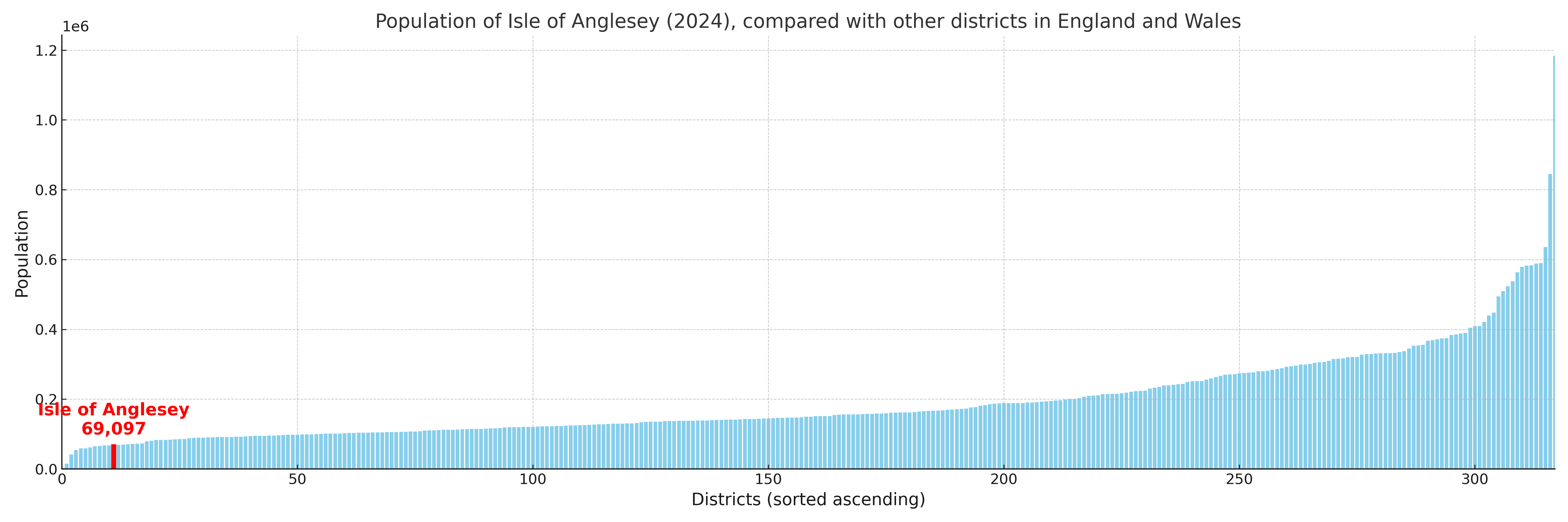
More local statistics and data for Isle of Anglesey can be found on the ONS statistics for Isle of Anglesey.
Latest news about Isle of Anglesey
Use the search box, or suggested search phrases, below to find recent news, council updates, planning stories, housing developments, transport changes, public services news, local elections, community issues and other local developments related to Isle of Anglesey. Results may include coverage from UK national, regional and local news websites, as well as official public-sector and local democracy sources.
- Isle of Anglesey council
- Isle of Anglesey planning
- Isle of Anglesey local elections
- Isle of Anglesey housing
- Isle of Anglesey transport
- Isle of Anglesey regeneration
- Isle of Anglesey public services