Powys
§ This page gives an overview of the Powys local authority district, bringing together key facts, maps, and data to help you quickly understand the area. This is one of 361 LAD profiles on Baseview.
Overview ⁞ Powys is the largest principal area in Wales by land, covering much of the eastern borderlands and uplands. It is predominantly rural, with farming and tourism dominating its economy, and towns like Brecon, Newtown, and Llandrindod Wells serving as key centres.
Powys Boundary Map
This map shows the official boundary of the Powys local authority district, based on the latest geographic data published by the Office for National Statistics (ONS). It provides a clear view of the district’s extent and helps you understand how the area fits within the wider regional and national landscape.
Contains OS data © Crown copyright and database right 2025. Source: Office for National Statistics licensed under the Open Government Licence v3.0.
The administrative boundary of Powys can also be viewed on OpenStreetMap: District Boundary of Powys.
Key Facts about Powys
What region is Powys in? Powys is in Wales, a statistical region and also a country in United Kingdom.
Is Powys a city? No, Powys is not a city. (Note: the UK has 76 officially designated cities.)
Who governs Powys? The local government for this district is: Powys County Council (Wales County Council).
▶ Official website of Powys County Council 🔗 powys.gov.uk
Which police force covers Powys? Policing in Powys is provided by Dyfed-Powys Police 🔗 dyfed-powys.police.uk, which serves 4 local authority districts: Carmarthenshire ⁞ Ceredigion ⁞ Pembrokeshire ⁞ Powys.
Constituencies in Powys
Powys is divided into 2 parliamentary constituencies, listed below in alphabetical order.
A constituency is a specific geographical area that elects one Member of Parliament (MP) to represent them in the House of Commons. The United Kingdom is divided into 650 parliamentary constituencies, 32 of them are in Wales. We have this list page for easy browsing of all UK parliamentary constituencies: List of Constituencies.
Wards in Powys
Powys is divided into 60 wards, listed below in alphabetical order.
- Aber-craf and Ystradgynlais
- Banwy, Llanfihangel and Llanwddyn
- Berriew and Castle Caereinion
- Brecon East
- Brecon West
- Bronllys and Felin-fach
- Builth
- Caersws
- Churchstoke
- Crickhowell with Cwmdu and Tretower
- Cwm-twrch
- Disserth and Trecoed with Newbridge
- Dolforwyn
- Forden and Montgomery
- Glantwymyn
- Glasbury
- Guilsfield
- Gwernyfed
- Hay
- Ithon Valley
- Kerry
- Knighton with Beguildy
- Llanafanfawr with Garth
- Llanbrynmair
- Llandinam with Dolfor
- Llandrindod North
- Llandrindod South
- Llandrinio
- Llandysilio
- Llanelwedd
- Llanfair Caereinion and Llanerfyl
- Llanfyllin
- Llangattock and Llangynidr
- Llangors with Bwlch
- Llangunllo with Norton
- Llangyniew and Meifod
- Llanidloes
- Llanrhaeadr-ym-Mochnant and Llansilin
- Llansantffraid
- Llanwrtyd Wells
- Llanyre with Nantmel
- Machynlleth
- Maescar and Llywel
- Newtown Central and South
- Newtown East
- Newtown North
- Newtown West
- Old Radnor
- Presteigne
- Rhayader
- Rhiwcynon
- Talgarth
- Talybont-on-Usk
- Tawe Uchaf
- Trelystan and Trewern
- Welshpool Castle
- Welshpool Gungrog
- Welshpool Llanerchyddol
- Ynyscedwyn
- Yscir with Honddu Isaf and Llanddew
In the UK, a ward is a subdivision of a local authority area, used mainly for electoral and statistical purposes. Defined by the ONS, wards represent the primary unit for local elections, each returning one or more councillors to the local council. Wards are also used as a key geography for presenting population and census data. We have this list page for easy browsing of all electoral wards: List of all Electoral Wards in the UK.
Communities in Powys
Powys has 110 communities, listed below in alphabetical order.
- Abbey Cwmhir
- Aberedw
- Aberhafesp
- Abermule with Llandyssil
- Banwy
- Bausley with Criggion
- Beguildy
- Berriew
- Betws Cedewain
- Brecon
- Bronllys
- Builth
- Cadfarch
- Caersws
- Carno
- Carreghofa
- Castle Caereinion
- Churchstoke
- Cilmery
- Clyro
- Cray
- Crickhowell
- Cwmdu and District
- Disserth and Trecoed
- Duhonw
- Dwyriw
- Erwood
- Felin-fach
- Forden with Leighton and Trelystan
- Gladestry
- Glantwymyn
- Glasbury
- Glascwm
- Glyn Tarell
- Guilsfield
- Gwernyfed
- Hay
- Honddu Isaf
- Kerry
- Knighton
- Llanafanfawr
- Llanbadarn Fawr
- Llanbadarn Fynydd
- Llanbister
- Llanbrynmair
- Llanddew
- Llanddewi Ystradenny
- Llandinam
- Llandrindod Wells
- Llandrinio
- Llandysilio
- Llanelwedd
- Llanerfyl
- Llanfair Caereinion
- Llanfechain
- Llanfihangel
- Llanfihangel Rhydithon
- Llanfrynach
- Llanfyllin
- Llangamarch
- Llangattock
- Llangedwyn
- Llangors
- Llangunllo
- Llangurig
- Llangynidr
- Llangyniew
- Llangynog
- Llanidloes
- Llanidloes Without
- Llanigon
- Llanrhaeadr-ym-Mochnant
- Llansantffraid
- Llansilin
- Llanwddyn
- Llanwrthwl
- Llanwrtyd Wells
- Llanyre
- Llywel
- Machynlleth
- Maescar
- Manafon
- Meifod
- Merthyr Cynog
- Mochdre and Penstrowed
- Montgomery
- Nantmel
- New Radnor
- Newtown and Llanllwchaiarn
- Old Radnor
- Painscastle
- Pen-y-Bont-Fawr
- Penybont
- Presteigne
- Rhayader
- St. Harmon
- Talgarth
- Talybont-on-Usk
- Tawe-Uchaf
- The Vale of Grwyney
- Trallong
- Trefeglwys
- Treflys
- Tregynon
- Trewern
- Welshpool
- Whitton
- Yscir
- Ystradfellte
- Ystradgynlais
In Wales, communities are the Welsh equivalent of civil parishes—the lowest tier of local government. Every part of Wales lies within a community, though only some have an elected community or town council. Where they exist, these councils handle very local matters and speak for residents to the county or county borough council. Like English civil parishes, communities are purely civil/administrative and are distinct from church parishes.
Post Towns in Powys
Below is a list of post towns in Powys, grouped by postcode area:
- LD ▸ Brecon (LD3) ⁞ Builth Wells (LD2) ⁞ Knighton (LD7) ⁞ Llandrindod Wells (LD1) ⁞ Llangammarch Wells (LD4) ⁞ Llanwrtyd Wells (LD5) ⁞ Presteigne (LD8) ⁞ Rhayader (LD6)
- SY ▸ Caersws (SY17) ⁞ Llanbrynmair (SY19) ⁞ Llandinam (SY17) ⁞ Llanfechain (SY22) ⁞ Llanfyllin (SY22) ⁞ Llanidloes (SY18) ⁞ Llansantffraid (SY22) ⁞ Llanymynech (SY22) ⁞ Machynlleth (SY20) ⁞ Meifod (SY22) ⁞ Montgomery (SY15) ⁞ Newtown (SY16) ⁞ Welshpool (SY21)
The UK postal hierarchy begins with broad postcode areas (such as “CB” or “M”), which are divided into smaller postcode districts (such as “CB8” or “M1”) to support accurate mail routing. Each postal address is anchored by a designated post town, the official locality name used in the UK postcode system, which operates independently from Local Authority Districts —the administrative boundaries used for council tax and local government services. Because they serve different purposes, a property’s postal address and its local authority district do not always align exactly.
Built-up Areas in Powys
Powys covers 55 built-up areas, listed below in alphabetical order.
- Abercrave
- Abermule
- Arddleen
- Berriew
- Brecon
- Bronllys
- Builth Wells
- Bwlch
- Caersws
- Churchstoke *
- Clyro
- Coelbren
- Crickhowell
- Crossgates (Powys)
- Cwm-twrch Uchaf *
- Cwmllynfell and Ystradowen *
- Forden
- Four Crosses (Powys)
- Guilsfield
- Gungrog
- Hay-on-Wye *
- Kerry
- Knighton *
- Llandinam
- Llandrindod Wells
- Llanelwedd
- Llanfair Caereinion
- Llanfechain
- Llanfyllin
- Llangattock
- Llangors
- Llangynidr
- Llanidloes
- Llanigon
- Llanrhaeadr-ym-Mochnant
- Llansantffraid-ym-Mechain
- Llanwrtyd Wells
- Llanymynech *
- Llanyre
- Machynlleth
- Meifod
- Montgomery
- Newbridge-on-Wye
- Newtown (Powys)
- Norton (Powys)
- Pontneddfechan *
- Presteigne *
- Rhayader
- Sennybridge
- Talgarth
- Three Cocks
- Tregynon
- Welshpool
- Ystalyfera *
- Ystradgynlais
In the UK, a Built-up Area (BUA) is a continuous urban area of at least 20 hectares (0.2 km²), defined by the ONS as land where buildings are generally no more than 200 metres apart, such as towns, cities, or large villages. (Note: A BUA name marked with an asterisk (*) indicates that the area is situated partly in the district of Powys.)
We have this list page for easy browsing of all built-up areas: List of all Built-up Areas in GB.
Railway Stations in Powys
Powys is served by a number of National Rail stations, providing rail connections to nearby towns, cities, and destinations across Great Britain. The railway stations listed below are located within the Powys Local Authority District and are grouped by train operating company for clarity.
- TfW Rail ▸ Welshpool (SY21 7AZ) ⁞ Newtown (Powys) (SY16 1BP) ⁞ Machynlleth (SY20 8BL) ⁞ Caersws (SY17 5HH) ⁞ Dovey Junction (SY20 8PZ) ⁞ Llandrindod (LD1 5BB) ⁞ Knighton (LD7 1DT) ⁞ Builth Road (LD2 3PY) ⁞ Llanwrtyd (LD5 4RW) ⁞ Knucklas (LD7 1PN) ⁞ Llangammarch (LD4 4EE) ⁞ Pen-Y-Bont (Mid Wales) (LD1 6RE) ⁞ Garth (Powys) (LD4 4AF) ⁞ Cilmeri (LD2 3NU) ⁞ Llanbister Road (LD1 5UW) ⁞ Sugar Loaf (LD5 4TE) ⁞ Dolau (LD1 5TG) ⁞ Llangynllo (LD7 1SY)
This is a district-level view only. For a complete list of all National Rail stations across Great Britain, see the UK National Rail Stations Directory.
Powys compared with other districts in the UK
This section shows how Powys compares with other local authority districts in the UK, using a variety of measures and rankings.
Powys has 60 electoral wards.

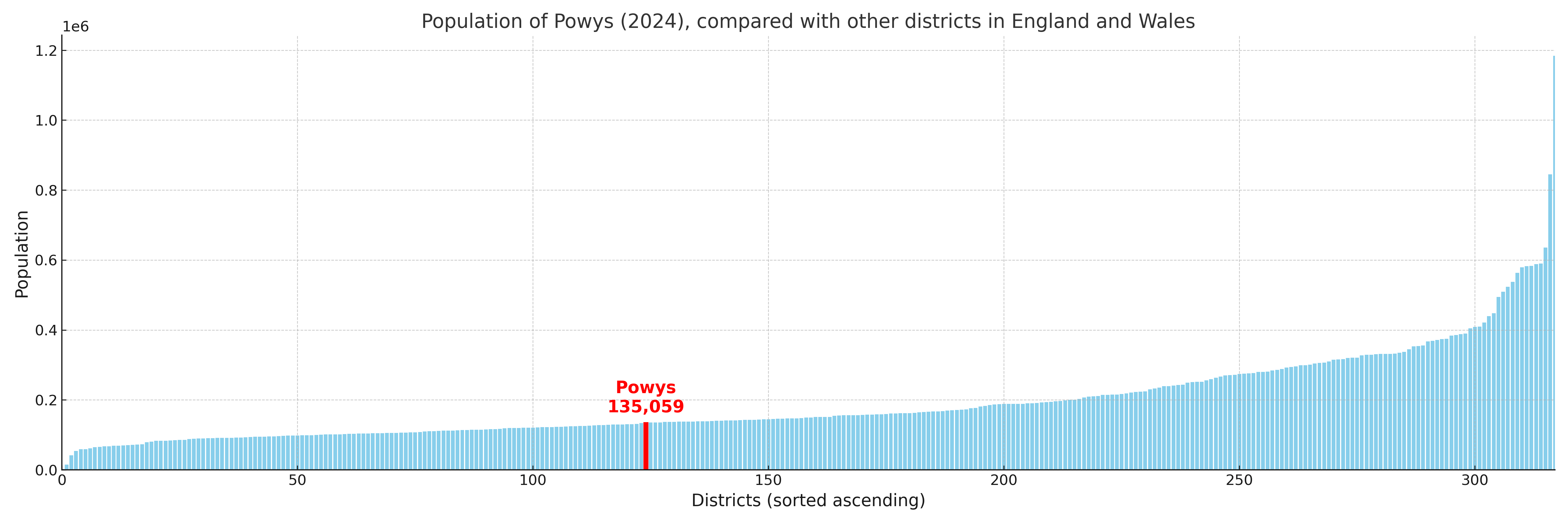
Powys has a population of 135,059 (2024 mid-year estimate by ONS)
More local statistics and data for Powys can be found on the ONS statistics for Powys.
Latest news about Powys
Use the search box, or suggested search phrases, below to find recent news, council updates, planning stories, housing developments, transport changes, public services news, local elections, community issues and other local developments related to Powys. Results may include coverage from UK national, regional and local news websites, as well as official public-sector and local democracy sources.
- Powys council
- Powys planning
- Powys local elections
- Powys housing
- Powys transport
- Powys regeneration
- Powys public services