Pembrokeshire
§ This page gives an overview of the Pembrokeshire local authority district, bringing together key facts, maps, and data to help you quickly understand the area. This is one of 361 LAD profiles on Baseview.
Overview ⁞ Pembrokeshire occupies the far southwest of Wales, known for its stunning coastline, beaches, and Pembrokeshire Coast National Park. Fishing, farming, and especially tourism are key industries, with towns like Haverfordwest, Tenby, and Milford Haven playing central roles.
Pembrokeshire Boundary Map
This map shows the official boundary of the Pembrokeshire local authority district, based on the latest geographic data published by the Office for National Statistics (ONS). It provides a clear view of the district’s extent and helps you understand how the area fits within the wider regional and national landscape.
Contains OS data © Crown copyright and database right 2025. Source: Office for National Statistics licensed under the Open Government Licence v3.0.
The administrative boundary of Pembrokeshire can also be viewed on OpenStreetMap: District Boundary of Pembrokeshire.
Key Facts about Pembrokeshire
What region is Pembrokeshire in? Pembrokeshire is in Wales, a statistical region and also a country in United Kingdom.
Is Pembrokeshire a city? Yes, Pembrokeshire is a city. Pembrokeshire holds official city status as one of the 76 designated cities in the UK.
Who governs Pembrokeshire? The local government for this district is: Pembrokeshire County Council (Wales County Council).
▶ Official website of Pembrokeshire County Council 🔗 pembrokeshire.gov.uk

Which police force covers Pembrokeshire? Policing in Pembrokeshire is provided by Dyfed-Powys Police 🔗 dyfed-powys.police.uk, which serves 4 local authority districts: Carmarthenshire ⁞ Ceredigion ⁞ Pembrokeshire ⁞ Powys.
Constituencies in Pembrokeshire
Pembrokeshire is divided into 2 parliamentary constituencies, listed below in alphabetical order.
A constituency is a specific geographical area that elects one Member of Parliament (MP) to represent them in the House of Commons. The United Kingdom is divided into 650 parliamentary constituencies, 32 of them are in Wales. We have this list page for easy browsing of all UK parliamentary constituencies: List of Constituencies.
Wards in Pembrokeshire
Pembrokeshire is divided into 59 wards, listed below in alphabetical order.
- Amroth and Saundersfoot North
- Boncath and Clydau
- Bro Gwaun
- Burton
- Camrose
- Carew and Jeffreyston
- Cilgerran and Eglwyswrw
- Crymych and Mynachlog-ddu
- East Williamston
- Fishguard: North East
- Fishguard: North West
- Goodwick
- Haverfordwest: Castle
- Haverfordwest: Garth
- Haverfordwest: Portfield
- Haverfordwest: Prendergast
- Haverfordwest: Priory
- Hundleton
- Johnston
- Kilgetty and Begelly
- Lampeter Velfrey
- Lamphey
- Letterston
- Llangwm
- Llanrhian
- Maenclochog
- Manorbier and Penally
- Martletwy
- Merlin's Bridge
- Milford: Central
- Milford: East
- Milford: Hakin
- Milford: Hubberston
- Milford: North
- Milford: West
- Narberth: Rural
- Narberth: Urban
- Newport and Dinas
- Neyland: East
- Neyland: West
- Pembroke Dock: Bufferland
- Pembroke Dock: Bush
- Pembroke Dock: Central
- Pembroke Dock: Market
- Pembroke Dock: Pennar
- Pembroke: Monkton and St Mary South
- Pembroke: St Mary North
- Pembroke: St Michael
- Rudbaxton and Spittal
- Saundersfoot South
- Solva
- St David's
- St Dogmaels
- St Florence and St Mary Out Liberty
- St Ishmael's
- Tenby: North
- Tenby: South
- The Havens
- Wiston
In the UK, a ward is a subdivision of a local authority area, used mainly for electoral and statistical purposes. Defined by the ONS, wards represent the primary unit for local elections, each returning one or more councillors to the local council. Wards are also used as a key geography for presenting population and census data. We have this list page for easy browsing of all electoral wards: List of all Electoral Wards in the UK.
Communities in Pembrokeshire
Pembrokeshire has 77 communities, listed below in alphabetical order.
- Ambleston
- Amroth
- Angle
- Boncath
- Brawdy
- Burton
- Camrose
- Carew
- Cilgerran
- Clydau
- Clynderwen
- Cosheston
- Crymych
- Cwm Gwaun
- Dale
- Dinas Cross
- East Williamston
- Eglwyswrw
- Fishguard and Goodwick
- Freystrop
- Haverfordwest
- Hayscastle
- Herbrandston
- Hook
- Hundleton
- Jeffreyston
- Johnston
- Kilgetty/Begelly
- Lampeter Velfrey
- Lamphey
- Letterston
- Llanddewi Velfrey
- Llandissilio West
- Llangwm
- Llanrhian
- Llanstadwell
- Llawhaden
- Maenclochog
- Manorbier
- Manordeifi
- Marloes and St. Brides
- Martletwy
- Mathry
- Merlin's Bridge
- Milford Haven
- Mynachlog-Ddu
- Narberth
- Nevern
- New Moat
- Newport
- Neyland
- Nolton and Roch
- Pembroke
- Pembroke Dock
- Penally
- Pencaer
- Puncheston
- Rosemarket
- Rudbaxton
- Saundersfoot
- Scleddau
- Solva
- Spittal
- St. David's and the Cathedral Close
- St. Dogmaels
- St. Florence
- St. Ishmael's
- St. Mary Out Liberty
- Stackpole and Castlemartin
- Templeton
- Tenby
- The Havens
- Tiers Cross
- Uzmaston, Boulston and Slebech
- Walwyn's Castle
- Wiston
- Wolfscastle
In Wales, communities are the Welsh equivalent of civil parishes—the lowest tier of local government. Every part of Wales lies within a community, though only some have an elected community or town council. Where they exist, these councils handle very local matters and speak for residents to the county or county borough council. Like English civil parishes, communities are purely civil/administrative and are distinct from church parishes.
Post Towns in Pembrokeshire
Below is a list of post towns in Pembrokeshire, grouped by postcode area:
- SA ▸ Boncath (SA37) ⁞ Clarbeston Road (SA63) ⁞ Clynderwen (SA66) ⁞ Crymych (SA41) ⁞ Fishguard (SA65) ⁞ Glogue (SA36) ⁞ Goodwick (SA64) ⁞ Haverfordwest (SA61 / SA62) ⁞ Kilgetty (SA68) ⁞ Llanfyrnach (SA35) ⁞ Milford Haven (SA73) ⁞ Narberth (SA67) ⁞ Newport (SA42) ⁞ Pembroke (SA71 / SA72) ⁞ Pembroke Dock (SA72) ⁞ Saundersfoot (SA69) ⁞ Tenby (SA70)
The UK postal hierarchy begins with broad postcode areas (such as “CB” or “M”), which are divided into smaller postcode districts (such as “CB8” or “M1”) to support accurate mail routing. Each postal address is anchored by a designated post town, the official locality name used in the UK postcode system, which operates independently from Local Authority Districts —the administrative boundaries used for council tax and local government services. Because they serve different purposes, a property’s postal address and its local authority district do not always align exactly.
Built-up Areas in Pembrokeshire
Pembrokeshire covers 64 built-up areas, listed below in alphabetical order.
- Abercych *
- Begelly
- Boncath
- Brawdy
- Broad Haven
- Broadmoor
- Broom (Pembrokeshire)
- Cardigan *
- Cilgerran *
- Clunderwen
- Cosheston
- Cross Hands
- Crundale
- Crymych
- Dale
- Dinas Cross
- Fishguard
- Freshwater East
- Goodwick
- Haverfordwest
- Hill Mountain
- Hook (Pembrokeshire)
- Hundleton
- Jameston
- Johnston
- Keeston
- Kilgetty
- Lamphey
- Letterston
- Llandissilio
- Llangwm
- Ludchurch
- Maenclochog
- Manorbier
- Merlin's Bridge
- Milford Haven
- Narberth
- New Hedges and Twy Cross
- Newport (Pembrokeshire)
- Neyland
- Pembroke
- Pembroke Dock
- Penally
- Pleasant Valley
- Robeston West
- Roch
- Rosemarket
- Sageston
- Saundersfoot
- Simpson Cross
- Solva
- Spittal (Pembrokeshire)
- St Davids
- St Dogmaels *
- St Florence
- St Ishmael's
- Tavernspite *
- Templeton
- Tenby
- Waterston
- Whitchurch (Pembrokeshire)
- Whitehill (Pembrokeshire)
- Whitland *
- Wooden
In the UK, a Built-up Area (BUA) is a continuous urban area of at least 20 hectares (0.2 km²), defined by the ONS as land where buildings are generally no more than 200 metres apart, such as towns, cities, or large villages. (Note: A BUA name marked with an asterisk (*) indicates that the area is situated partly in the district of Pembrokeshire.)
We have this list page for easy browsing of all built-up areas: List of all Built-up Areas in GB.
Railway Stations in Pembrokeshire
Pembrokeshire is served by a number of National Rail stations, providing rail connections to nearby towns, cities, and destinations across Great Britain. The railway stations listed below are located within the Pembrokeshire Local Authority District and are grouped by train operating company for clarity.
- TfW Rail ▸ Tenby (SA70 7JY) ⁞ Haverfordwest (SA61 1TY) ⁞ Milford Haven (SA73 3AB) ⁞ Pembroke Dock (SA72 6HN) ⁞ Pembroke (SA71 4AH) ⁞ Clunderwen (SA66 7NG) ⁞ Narberth (SA67 8TY) ⁞ Fishguard and Goodwick (SA64 0DG) ⁞ Kilgetty (SA68 0UF) ⁞ Saundersfoot (SA69 9BG) ⁞ Manorbier (SA70 7SN) ⁞ Fishguard Harbour (SA64 0BU) ⁞ Johnston (Pembs) (SA62 3PL) ⁞ Penally (SA70 7PS) ⁞ Clarbeston Road (SA63 4UH)
This is a district-level view only. For a complete list of all National Rail stations across Great Britain, see the UK National Rail Stations Directory.
Pembrokeshire compared with other districts in the UK
This section shows how Pembrokeshire compares with other local authority districts in the UK, using a variety of measures and rankings.
Pembrokeshire has 59 electoral wards.

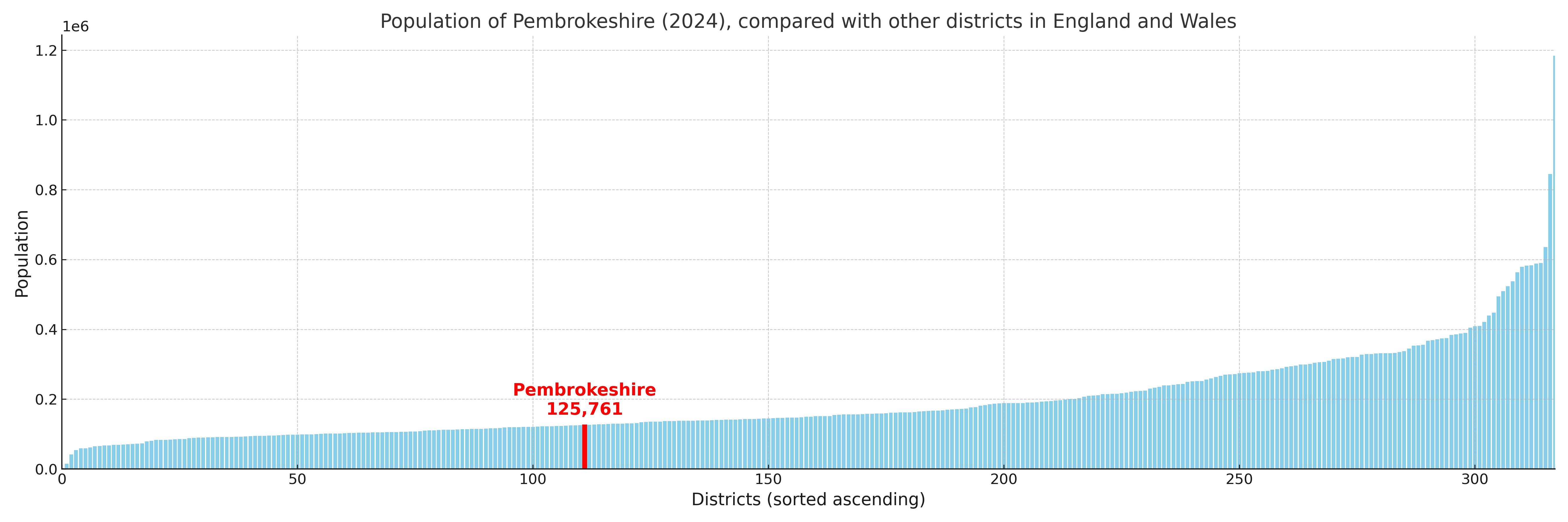
Pembrokeshire has a population of 125,761 (2024 mid-year estimate by ONS)
More local statistics and data for Pembrokeshire can be found on the ONS statistics for Pembrokeshire.
Latest news about Pembrokeshire
Use the search box, or suggested search phrases, below to find recent news, council updates, planning stories, housing developments, transport changes, public services news, local elections, community issues and other local developments related to Pembrokeshire. Results may include coverage from UK national, regional and local news websites, as well as official public-sector and local democracy sources.
- Pembrokeshire council
- Pembrokeshire planning
- Pembrokeshire local elections
- Pembrokeshire housing
- Pembrokeshire transport
- Pembrokeshire regeneration
- Pembrokeshire public services