Gwynedd
§ This page gives an overview of the Gwynedd local authority district, bringing together key facts, maps, and data to help you quickly understand the area. This is one of 361 LAD profiles on Baseview.
Overview ⁞ Gwynedd is a large county in northwest Wales, encompassing much of Snowdonia National Park and a long coastline. It includes the university city of Bangor and towns like Porthmadog and Pwllheli. The area is strongly Welsh-speaking, with tourism, agriculture, and education central to its economy.
Gwynedd Boundary Map
This map shows the official boundary of the Gwynedd local authority district, based on the latest geographic data published by the Office for National Statistics (ONS). It provides a clear view of the district’s extent and helps you understand how the area fits within the wider regional and national landscape.
Contains OS data © Crown copyright and database right 2025. Source: Office for National Statistics licensed under the Open Government Licence v3.0.
The administrative boundary of Gwynedd can also be viewed on OpenStreetMap: District Boundary of Gwynedd.
Key Facts about Gwynedd
What region is Gwynedd in? Gwynedd is in Wales, a statistical region and also a country in United Kingdom.
Is Gwynedd a city? Yes, Gwynedd is a city. Gwynedd holds official city status as one of the 76 designated cities in the UK.
Who governs Gwynedd? The local government for this district is: Gwynedd Council (Wales County Council).
▶ Official website of Gwynedd Council 🔗 gwynedd.llyw.cymru
Which police force covers Gwynedd? Policing in Gwynedd is provided by North Wales Police 🔗 northwales.police.uk, which serves 6 local authority districts: Conwy ⁞ Denbighshire ⁞ Flintshire ⁞ Gwynedd ⁞ Isle of Anglesey ⁞ Wrexham.
Gwynedd in International Geographies
In the International Territorial Levels (ITLs) hierarchy, Gwynedd is an ITLs Level 3 area:
- (ITL 1) Wales
- (ITL 2) ⇒ North Wales
- (ITL 3) ⇒⇒ Gwynedd
The International Territorial Levels are used by OECD member countries for statistical purposes to classify administrative areas. We have this listable page for easy browsing of ITL names and codes: International Territorial Levels.
Constituencies in Gwynedd
Gwynedd is divided into 2 parliamentary constituencies, listed below in alphabetical order.
A constituency is a specific geographical area that elects one Member of Parliament (MP) to represent them in the House of Commons. The United Kingdom is divided into 650 parliamentary constituencies, 32 of them are in Wales. We have this list page for easy browsing of all UK parliamentary constituencies: List of Constituencies.
Wards in Gwynedd
Gwynedd is divided into 65 wards, listed below in alphabetical order.
- Aberdyfi
- Abererch
- Abermaw
- Abersoch gyda Llanengan
- Arllechwedd
- Arthog a Llangelynnin
- Bethel a'r Felinheli
- Bowydd a'r Rhiw
- Brithdir and Llanfachreth/Ganllwyd/Llanelltyd
- Bro Dysynni
- Cadnant
- Canol Bangor
- Canol Bethesda
- Canol Tref Caernarfon
- Clynnog
- Corris a Mawddwy
- Criccieth
- Cwm-y-glo
- De Dolgellau
- De Pwllheli
- Deiniolen
- Dewi
- Diffwys a Maenofferen
- Dolbenmaen
- Dwyrain Bangor
- Dwyrain Porthmadog
- Dyffryn Ardudwy
- Efailnewydd a Buan
- Gerlan
- Glaslyn
- Glyder
- Gogledd Dolgellau
- Gogledd Pwllheli
- Gorllewin Porthmadog
- Gorllewin Tywyn
- Harlech a Llanbedr
- Hendre
- Llanbedrog gyda Mynytho
- Llanberis
- Llandderfel
- Llanllyfni
- Llanrug
- Llanuwchllyn
- Llanwnda
- Llanystumdwy
- Menai
- Morfa Nefyn a Thudweiliog
- Morfa Tywyn
- Nefyn
- Peblig
- Pen draw Llŷn
- Pen-y-groes
- Penisa'r-waun
- Penrhyndeudraeth
- Rachub
- Teigl
- Trawsfynydd
- Tre-garth a Mynydd Llandygai
- Tryfan
- Waunfawr
- Y Bala
- Y Bontnewydd
- Y Faenol
- Y Groeslon
- Yr Eifl
In the UK, a ward is a subdivision of a local authority area, used mainly for electoral and statistical purposes. Defined by the ONS, wards represent the primary unit for local elections, each returning one or more councillors to the local council. Wards are also used as a key geography for presenting population and census data. We have this list page for easy browsing of all electoral wards: List of all Electoral Wards in the UK.
Communities in Gwynedd
Gwynedd has 64 communities, listed below in alphabetical order.
- Aber
- Aberdaron
- Aberdovey
- Arthog
- Bala
- Bangor
- Barmouth
- Beddgelert
- Bethesda
- Betws Garmon
- Bontnewydd
- Botwnnog
- Brithdir and Llanfachreth
- Bryn-crug
- Buan
- Caernarfon
- Clynnog
- Corris
- Criccieth
- Dolbenmaen
- Dolgellau
- Dyffryn Ardudwy
- Ffestiniog
- Ganllwyd
- Harlech
- Llanaelhaearn
- Llanbedr
- Llanbedrog
- Llanberis
- Llanddeiniolen
- Llandderfel
- Llandwrog
- Llandygai
- Llanegryn
- Llanelltyd
- Llanengan
- Llanfair
- Llanfihangel-y-Pennant
- Llanfrothen
- Llangelynnin
- Llangywer
- Llanllechid
- Llanllyfni
- Llannor
- Llanrug
- Llanuwchllyn
- Llanwnda
- Llanycil
- Llanystumdwy
- Maentwrog
- Mawddwy
- Nefyn
- Pennal
- Penrhyndeudraeth
- Pentir
- Pistyll
- Porthmadog
- Pwllheli
- Talsarnau
- Trawsfynydd
- Tudweiliog
- Tywyn
- Waunfawr
- Y Felinheli
In Wales, communities are the Welsh equivalent of civil parishes—the lowest tier of local government. Every part of Wales lies within a community, though only some have an elected community or town council. Where they exist, these councils handle very local matters and speak for residents to the county or county borough council. Like English civil parishes, communities are purely civil/administrative and are distinct from church parishes.
Post Towns in Gwynedd
Below is a list of post towns in Gwynedd, grouped by postcode area:
- LL ▸ Aberdyfi (LL35) ⁞ Arthog (LL39) ⁞ Bala (LL23) ⁞ Bangor (LL57) ⁞ Barmouth (LL42) ⁞ Blaenau Ffestiniog (LL41) ⁞ Caernarfon (LL54 / LL55) ⁞ Criccieth (LL52) ⁞ Dolgellau (LL40) ⁞ Dyffryn Ardudwy (LL44) ⁞ Fairbourne (LL38) ⁞ Garndolbenmaen (LL51) ⁞ Harlech (LL46) ⁞ Llanbedr (LL45) ⁞ Llwyngwril (LL37) ⁞ Penrhyndeudraeth (LL48) ⁞ Porthmadog (LL49) ⁞ Pwllheli (LL53) ⁞ Talsarnau (LL47) ⁞ Tywyn (LL36) ⁞ Y Felinheli (LL56)
The UK postal hierarchy begins with broad postcode areas (such as “CB” or “M”), which are divided into smaller postcode districts (such as “CB8” or “M1”) to support accurate mail routing. Each postal address is anchored by a designated post town, the official locality name used in the UK postcode system, which operates independently from Local Authority Districts —the administrative boundaries used for council tax and local government services. Because they serve different purposes, a property’s postal address and its local authority district do not always align exactly.
Built-up Areas in Gwynedd
Gwynedd covers 54 built-up areas, listed below in alphabetical order.
- Aberdovey
- Abersoch
- Bangor
- Barmouth
- Bethel
- Bethesda
- Blaenau Ffestiniog
- Bontnewydd
- Bryncrug
- Caeathro
- Caernarfon
- Carmel
- Clwt-y-bont
- Criccieth
- Dinas Dinlle
- Dolgellau
- Dyffryn Ardudwy
- Fairbourne
- Friog
- Gellilydan
- Groeslon
- Hafan y Mor
- Harlech
- Llan Ffestiniog
- Llanbedr
- Llanbedrog
- Llanberis
- Llandwrog
- Llandygai
- Llanllyfni
- Llanrug
- Llwyngwril
- Morfa Bychan
- Morfa Nefyn
- Nefyn
- Pantperthog
- Penisa'r Waun
- Penrhyndeudraeth
- Penygroes
- Porthmadog
- Pwllheli
- Rachub
- Rhostryfan
- Tal-y-bont (Gwynedd)
- Tal-y-waenydd
- Talysarn
- Trawsfynydd
- Trefor
- Tregarth
- Tremadog
- Tywyn
- Waunfawr
- Y Bala
- Y Felinheli
In the UK, a Built-up Area (BUA) is a continuous urban area of at least 20 hectares (0.2 km²), defined by the ONS as land where buildings are generally no more than 200 metres apart, such as towns, cities, or large villages. (Note: A BUA name marked with an asterisk (*) indicates that the area is situated partly in the district of Gwynedd.)
We have this list page for easy browsing of all built-up areas: List of all Built-up Areas in GB.
Railway Stations in Gwynedd
Gwynedd is served by a number of National Rail stations, providing rail connections to nearby towns, cities, and destinations across Great Britain. The railway stations listed below are located within the Gwynedd Local Authority District and are grouped by train operating company for clarity.
- TfW Rail ▸ Bangor (Gwynedd) (LL57 1LZ) ⁞ Barmouth (LL42 1LS) ⁞ Tywyn (LL36 9EY) ⁞ Harlech (LL46 2UL) ⁞ Porthmadog (LL49 9HT) ⁞ Pwllheli (LL53 5HG) ⁞ Penrhyndeudraeth (LL48 6LN) ⁞ Aberdovey (LL35 0NR) ⁞ Blaenau Ffestiniog (LL41 3HE) ⁞ Fairbourne (LL38 2AQ) ⁞ Llwyngwril (LL37 2JS) ⁞ Criccieth (LL52 0RW) ⁞ Talybont (LL43 2AQ) ⁞ Dyffryn Ardudwy (LL42 2EU) ⁞ Minffordd (LL48 6HG) ⁞ Llanbedr (LL45 2LR) ⁞ Morfa Mawddach (LL39 1BQ) ⁞ Penychain (LL53 6HJ) ⁞ Penhelig (LL35 0LU) ⁞ Llandanwg (LL46 2SB) ⁞ Talsarnau (LL47 6UA) ⁞ Llanaber (LL42 1AZ) ⁞ Abererch (LL53 6PJ) ⁞ Tonfanau (LL36 8LP) ⁞ Pensarn (Gwynedd) (LL45 2HP) ⁞ Llandecwyn (LL47 6YL) ⁞ Tygwyn (LL47 6TF)
This is a district-level view only. For a complete list of all National Rail stations across Great Britain, see the UK National Rail Stations Directory.
Gwynedd compared with other districts in the UK
This section shows how Gwynedd compares with other local authority districts in the UK, using a variety of measures and rankings.
Gwynedd has 65 electoral wards.

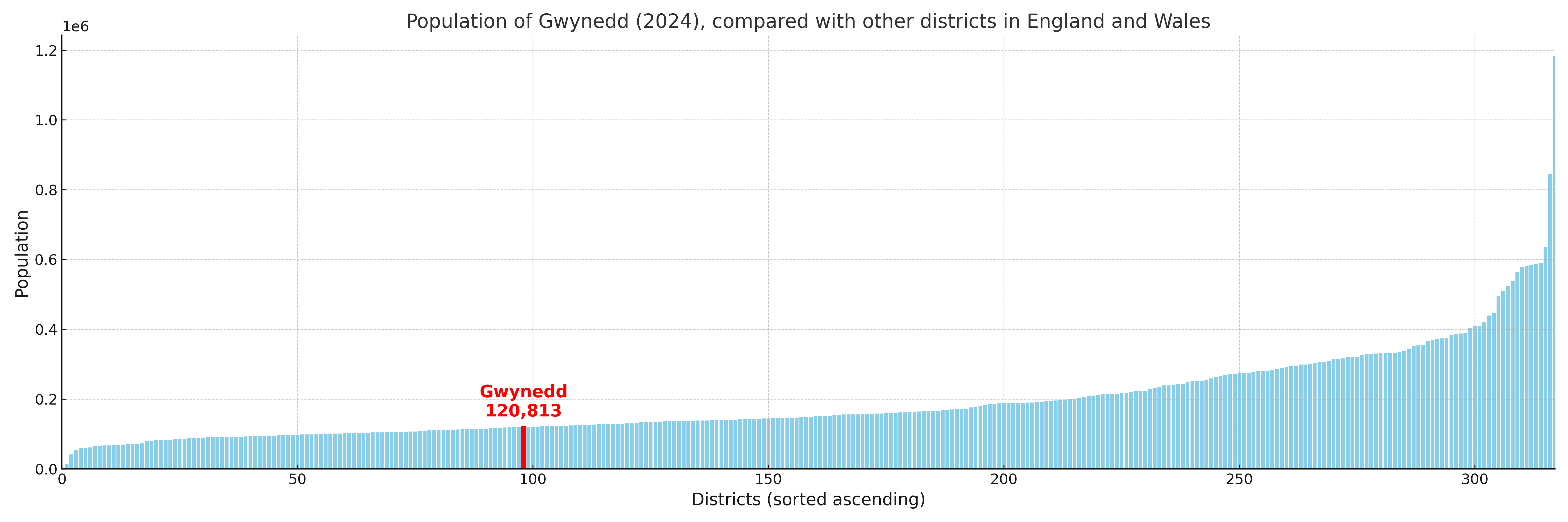
Gwynedd has a population of 120,813 (2024 mid-year estimate by ONS)
More local statistics and data for Gwynedd can be found on the ONS statistics for Gwynedd.
Latest news about Gwynedd
Use the search box, or suggested search phrases, below to find recent news, council updates, planning stories, housing developments, transport changes, public services news, local elections, community issues and other local developments related to Gwynedd. Results may include coverage from UK national, regional and local news websites, as well as official public-sector and local democracy sources.
- Gwynedd council
- Gwynedd planning
- Gwynedd local elections
- Gwynedd housing
- Gwynedd transport
- Gwynedd regeneration
- Gwynedd public services