Flintshire
§ This page gives an overview of the Flintshire local authority district, bringing together key facts, maps, and data to help you quickly understand the area. This is one of 361 LAD profiles on Baseview.
Overview ⁞ Flintshire is in northeast Wales, bordering England and close to Chester. It has a strong manufacturing and aerospace sector, including Airbus operations in Broughton, and combines rural areas with towns like Mold and Flint.
Flintshire Boundary Map
This map shows the official boundary of the Flintshire local authority district, based on the latest geographic data published by the Office for National Statistics (ONS). It provides a clear view of the district’s extent and helps you understand how the area fits within the wider regional and national landscape.
Contains OS data © Crown copyright and database right 2025. Source: Office for National Statistics licensed under the Open Government Licence v3.0.
The administrative boundary of Flintshire can also be viewed on OpenStreetMap: District Boundary of Flintshire.
Key Facts about Flintshire
What region is Flintshire in? Flintshire is in Wales, a statistical region and also a country in United Kingdom.
Is Flintshire a city? No, Flintshire is not a city. (Note: the UK has 76 officially designated cities.)
Who governs Flintshire? The local government for this district is: Flintshire County Council (Wales County Council).
▶ Official website of Flintshire County Council 🔗 flintshire.gov.uk

Which police force covers Flintshire? Policing in Flintshire is provided by North Wales Police 🔗 northwales.police.uk, which serves 6 local authority districts: Conwy ⁞ Denbighshire ⁞ Flintshire ⁞ Gwynedd ⁞ Isle of Anglesey ⁞ Wrexham.
Flintshire in International Geographies
In the International Territorial Levels (ITLs) hierarchy, Flintshire is within an ITLs Level 3 area:
- (ITL 1) Wales
- (ITL 2) ⇒ North Wales
- (ITL 3) ⇒⇒ Flintshire and Wrexham
The International Territorial Levels are used by OECD member countries for statistical purposes to classify administrative areas. We have this listable page for easy browsing of ITL names and codes: International Territorial Levels.
Constituencies in Flintshire
Flintshire is divided into 2 parliamentary constituencies, listed below in alphabetical order.
A constituency is a specific geographical area that elects one Member of Parliament (MP) to represent them in the House of Commons. The United Kingdom is divided into 650 parliamentary constituencies, 32 of them are in Wales. We have this list page for easy browsing of all UK parliamentary constituencies: List of Constituencies.
Wards in Flintshire
Flintshire is divided into 45 wards, listed below in alphabetical order.
- Argoed and New Brighton
- Bagillt
- Broughton North East
- Broughton South
- Brynford and Halkyn
- Buckley: Bistre East
- Buckley: Bistre West
- Buckley: Mountain
- Buckley: Pentrobin
- Caergwrle
- Caerwys
- Cilcain
- Connah's Quay Central
- Connah's Quay South
- Connah's Quay: Golftyn
- Connah's Quay: Wepre
- Flint: Castle
- Flint: Coleshill and Trelawny
- Flint: Oakenholt
- Greenfield
- Gwernaffield and Gwernymynydd
- Hawarden: Aston
- Hawarden: Ewloe
- Hawarden: Mancot
- Higher Kinnerton
- Holywell Central
- Holywell East
- Holywell West
- Hope
- Leeswood
- Llanasa and Trelawnyd
- Llanfynydd
- Mold East
- Mold South
- Mold West
- Mold: Broncoed
- Mostyn
- Northop
- Pen-y-ffordd
- Queensferry and Sealand
- Saltney Ferry
- Shotton East and Shotton Higher
- Shotton West
- Treuddyn
- Whitford
In the UK, a ward is a subdivision of a local authority area, used mainly for electoral and statistical purposes. Defined by the ONS, wards represent the primary unit for local elections, each returning one or more councillors to the local council. Wards are also used as a key geography for presenting population and census data. We have this list page for easy browsing of all electoral wards: List of all Electoral Wards in the UK.
Communities in Flintshire
Flintshire has 34 communities, listed below in alphabetical order.
- Argoed
- Bagillt
- Broughton and Bretton
- Brynford
- Buckley
- Caerwys
- Cilcain
- Connah's Quay
- Flint
- Gwernaffield with Pantymwyn
- Gwernymynydd
- Halkyn
- Hawarden
- Higher Kinnerton
- Holywell
- Hope
- Leeswood and Pontblyddyn
- Llanasa
- Llanfynydd
- Mold
- Mostyn
- Nannerch
- Nercwys
- Northop
- Northop Hall
- Penyffordd
- Queensferry
- Saltney
- Sealand
- Shotton
- Trelawnyd and Gwaenysgor
- Treuddyn
- Whitford
- Ysceifiog
In Wales, communities are the Welsh equivalent of civil parishes—the lowest tier of local government. Every part of Wales lies within a community, though only some have an elected community or town council. Where they exist, these councils handle very local matters and speak for residents to the county or county borough council. Like English civil parishes, communities are purely civil/administrative and are distinct from church parishes.
Post Towns in Flintshire
Below is a list of post towns in Flintshire, grouped by postcode area:
- CH ▸ Bagillt (CH6) ⁞ Buckley (CH7) ⁞ Deeside (CH5) ⁞ Flint (CH6) ⁞ Holywell (CH8) ⁞ Mold (CH7)
The UK postal hierarchy begins with broad postcode areas (such as “CB” or “M”), which are divided into smaller postcode districts (such as “CB8” or “M1”) to support accurate mail routing. Each postal address is anchored by a designated post town, the official locality name used in the UK postcode system, which operates independently from Local Authority Districts —the administrative boundaries used for council tax and local government services. Because they serve different purposes, a property’s postal address and its local authority district do not always align exactly.
Built-up Areas in Flintshire
Flintshire covers 43 built-up areas, listed below in alphabetical order.
- Aston (Flintshire)
- Bagillt
- Broughton (Flintshire)
- Buckley
- Caerwys
- Chester *
- Cilcain
- Connah's Quay
- Ffynnongroyw
- Flint
- Flint Mountain
- Garden City
- Gorsedd
- Greenfield (Flintshire)
- Gronant *
- Gwernaffield-y-Waun
- Gwernymynydd *
- Gwespyr *
- Hawarden
- Higher Kinnerton
- Holywell (Flintshire)
- Hope (Flintshire) *
- Leeswood
- Lixwm
- Mold
- Mostyn
- Mynydd Isa
- New Brighton
- Northop
- Northop Hall
- Padeswood
- Pantymwyn
- Pen-y-ffordd
- Pentre Halkyn
- Penyffordd
- Prestatyn *
- Rhosesmor
- Rhydymwyn
- Shotton
- Soughton
- Talacre
- Trelogan
- Treuddyn
In the UK, a Built-up Area (BUA) is a continuous urban area of at least 20 hectares (0.2 km²), defined by the ONS as land where buildings are generally no more than 200 metres apart, such as towns, cities, or large villages. (Note: A BUA name marked with an asterisk (*) indicates that the area is situated partly in the district of Flintshire.)
We have this list page for easy browsing of all built-up areas: List of all Built-up Areas in GB.
Railway Stations in Flintshire
Flintshire is served by a number of National Rail stations, providing rail connections to nearby towns, cities, and destinations across Great Britain. The railway stations listed below are located within the Flintshire Local Authority District and are grouped by train operating company for clarity.
- TfW Rail ▸ Flint (CH6 5PG) ⁞ Shotton (CH5 1BX) ⁞ Buckley (CH7 3AY) ⁞ Hawarden (CH5 1PY) ⁞ Penyffordd (CH4 0JT) ⁞ Hope (Flintshire) (LL12 9NJ) ⁞ Caergwrle (LL12 9DU) ⁞ Hawarden Bridge (CH5 1PY) ⁞ Cefn-Y-Bedd (LL12 9UU)
This is a district-level view only. For a complete list of all National Rail stations across Great Britain, see the UK National Rail Stations Directory.
Flintshire compared with other districts in the UK
This section shows how Flintshire compares with other local authority districts in the UK, using a variety of measures and rankings.
Flintshire has 45 electoral wards.

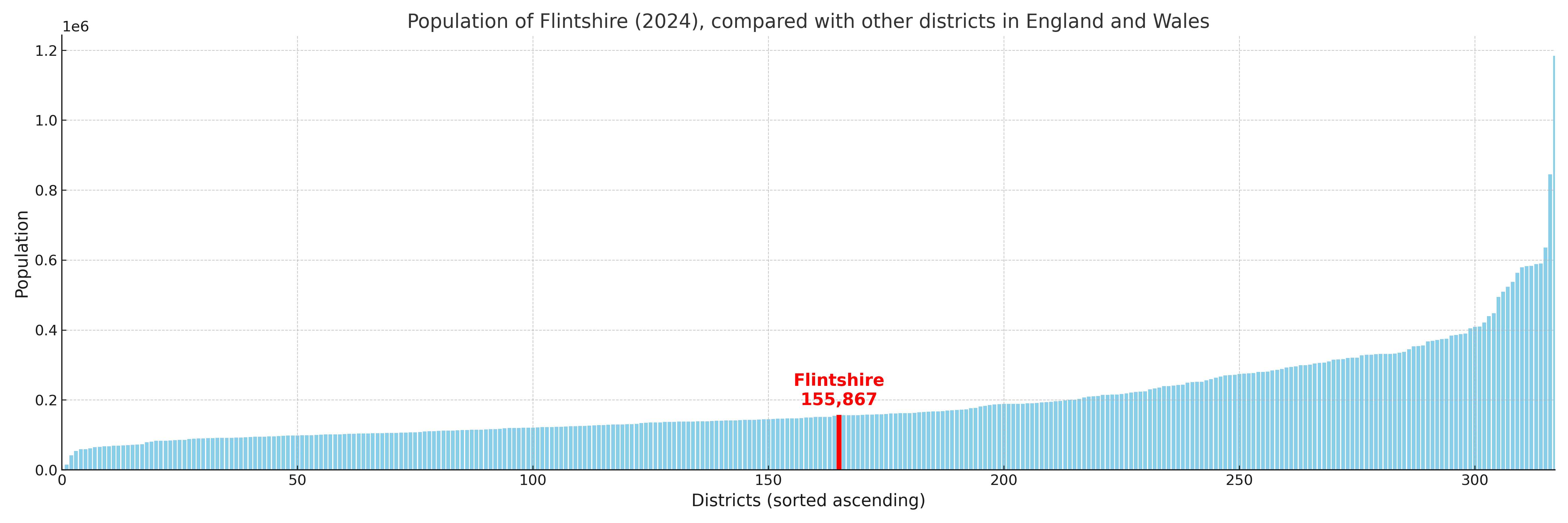
Flintshire has a population of 155,867 (2024 mid-year estimate by ONS)

More local statistics and data for Flintshire can be found on the ONS statistics for Flintshire.