Conwy
§ This page gives an overview of the Conwy local authority district, bringing together key facts, maps, and data to help you quickly understand the area. This is one of 361 LAD profiles on Baseview.
Overview ⁞ Conwy in north Wales stretches from the Conwy Valley to the coastal resorts of Llandudno and Colwyn Bay. It features the UNESCO-listed Conwy Castle and Snowdonia National Park, with tourism playing a major role alongside farming and small businesses.
Conwy Boundary Map
This map shows the official boundary of the Conwy local authority district, based on the latest geographic data published by the Office for National Statistics (ONS). It provides a clear view of the district’s extent and helps you understand how the area fits within the wider regional and national landscape.
Contains OS data © Crown copyright and database right 2025. Source: Office for National Statistics licensed under the Open Government Licence v3.0.
The administrative boundary of Conwy can also be viewed on OpenStreetMap: District Boundary of Conwy.
Key Facts about Conwy
What region is Conwy in? Conwy is in Wales, a statistical region and also a country in United Kingdom.
Is Conwy a city? No, Conwy is not a city. (Note: the UK has 76 officially designated cities.)
Who governs Conwy? The local government for this district is: Conwy County Borough Council (Wales County Borough Council).
▶ Official website of Conwy County Borough Council 🔗 conwy.gov.uk
Which police force covers Conwy? Policing in Conwy is provided by North Wales Police 🔗 northwales.police.uk, which serves 6 local authority districts: Conwy ⁞ Denbighshire ⁞ Flintshire ⁞ Gwynedd ⁞ Isle of Anglesey ⁞ Wrexham.
Conwy in International Geographies
In the International Territorial Levels (ITLs) hierarchy, Conwy is within an ITLs Level 3 area:
- (ITL 1) Wales
- (ITL 2) ⇒ North Wales
- (ITL 3) ⇒⇒ Conwy and Denbighshire
The International Territorial Levels are used by OECD member countries for statistical purposes to classify administrative areas. We have this listable page for easy browsing of ITL names and codes: International Territorial Levels.
Constituencies in Conwy
Conwy is divided into 2 parliamentary constituencies, listed below in alphabetical order.
A constituency is a specific geographical area that elects one Member of Parliament (MP) to represent them in the House of Commons. The United Kingdom is divided into 650 parliamentary constituencies, 32 of them are in Wales. We have this list page for easy browsing of all UK parliamentary constituencies: List of Constituencies.
Wards in Conwy
Conwy is divided into 30 wards, listed below in alphabetical order.
- Betws-y-Coed and Trefriw
- Betws-yn-Rhos
- Bryn
- Caerhun
- Colwyn
- Conwy
- Craig-y-don
- Deganwy
- Eglwys-bach a Llangernyw
- Eirias
- Gele and Llanddulas
- Glyn
- Glyn y Marl
- Gogarth Mostyn
- Kinmel Bay
- Llandrillo-yn-Rhos
- Llanrwst a Llanddoged
- Llansanffraid
- Llansannan
- Llysfaen
- Mochdre
- Pandy
- Pen-sarn Pentre Mawr
- Penmaenmawr
- Penrhyn
- Rhiw
- Towyn
- Tudno
- Uwch Aled
- Uwch Conwy
In the UK, a ward is a subdivision of a local authority area, used mainly for electoral and statistical purposes. Defined by the ONS, wards represent the primary unit for local elections, each returning one or more councillors to the local council. Wards are also used as a key geography for presenting population and census data. We have this list page for easy browsing of all electoral wards: List of all Electoral Wards in the UK.
Communities in Conwy
Conwy has 35 communities, listed below in alphabetical order.
- Abergele
- Betws yn Rhos
- Betws-y-Coed
- Bro Garmon
- Bro Machno
- Caerhun
- Capel Curig
- Cerrigydrudion
- Colwyn Bay
- Conwy
- Dolgarrog
- Dolwyddelan
- Eglwysbach
- Henryd
- Kinmel Bay and Towyn
- Llanddoged and Maenan
- Llanddulas and Rhyd-y-Foel
- Llandudno
- Llanfair Talhaiarn
- Llanfairfechan
- Llanfihangel Glyn Myfyr
- Llangernyw
- Llangwm
- Llannefydd
- Llanrwst
- Llansanffraid Glan Conwy
- Llansannan
- Llysfaen
- Mochdre
- Old Colwyn
- Penmaenmawr
- Pentrefoelas
- Rhos-on-Sea
- Trefriw
- Ysbyty Ifan
In Wales, communities are the Welsh equivalent of civil parishes—the lowest tier of local government. Every part of Wales lies within a community, though only some have an elected community or town council. Where they exist, these councils handle very local matters and speak for residents to the county or county borough council. Like English civil parishes, communities are purely civil/administrative and are distinct from church parishes.
Post Towns in Conwy
Below is a list of post towns in Conwy, grouped by postcode area:
- LL ▸ Abergele (LL22) ⁞ Betws-y-Coed (LL24) ⁞ Colwyn Bay (LL28 / LL29) ⁞ Conwy (LL31 / LL32) ⁞ Dolwyddelan (LL25) ⁞ Llandudno (LL30) ⁞ Llandudno Junction (LL31) ⁞ Llanfairfechan (LL33) ⁞ Llanrwst (LL26) ⁞ Penmaenmawr (LL34) ⁞ Trefriw (LL27)
The UK postal hierarchy begins with broad postcode areas (such as “CB” or “M”), which are divided into smaller postcode districts (such as “CB8” or “M1”) to support accurate mail routing. Each postal address is anchored by a designated post town, the official locality name used in the UK postcode system, which operates independently from Local Authority Districts —the administrative boundaries used for council tax and local government services. Because they serve different purposes, a property’s postal address and its local authority district do not always align exactly.
Built-up Areas in Conwy
Conwy covers 23 built-up areas, listed below in alphabetical order.
- Abergele
- Betws-y-Coed
- Betws-yn-Rhos
- Bryn Pydew
- Colwyn Bay
- Conwy
- Dolgarrog
- Dwygyfylchi
- Henryd
- Kinmel Bay *
- Llanddulas
- Llandudno
- Llanfairfechan
- Llangernyw
- Llanrwst
- Llansanffraid Glan Conwy
- Llansannan
- Mynydd Marian
- Penmaenmawr
- Penrhyn Bay
- Penrhyn-side
- Pensarn
- Trefriw
In the UK, a Built-up Area (BUA) is a continuous urban area of at least 20 hectares (0.2 km²), defined by the ONS as land where buildings are generally no more than 200 metres apart, such as towns, cities, or large villages. (Note: A BUA name marked with an asterisk (*) indicates that the area is situated partly in the district of Conwy.)
We have this list page for easy browsing of all built-up areas: List of all Built-up Areas in GB.
Railway Stations in Conwy
Conwy is served by a number of National Rail stations, providing rail connections to nearby towns, cities, and destinations across Great Britain. The railway stations listed below are located within the Conwy Local Authority District and are grouped by train operating company for clarity.
- TfW Rail ▸ Llandudno (LL30 2AF) ⁞ Llandudno Junction (LL31 9NB) ⁞ Colwyn Bay (LL29 8DF) ⁞ Abergele and Pensarn (LL22 7PR) ⁞ Conwy (LL32 8LD) ⁞ Betws-y-Coed (LL24 0AE) ⁞ Llanfairfechan (LL33 0BP) ⁞ Llanrwst (LL26 0AD) ⁞ Deganwy (LL31 9EJ) ⁞ Penmaenmawr (LL34 6AT) ⁞ Glan Conwy (LL28 5ED) ⁞ Dolwyddelan (LL25 0TJ) ⁞ North Llanrwst (LL26 0EG) ⁞ Dolgarrog (LL26 0YR) ⁞ Tal-y-Cafn (LL28 5RR) ⁞ Pont-y-Pant (LL25 0DQ) ⁞ Roman Bridge (LL25 0JE)
This is a district-level view only. For a complete list of all National Rail stations across Great Britain, see the UK National Rail Stations Directory.
Conwy compared with other districts in the UK
This section shows how Conwy compares with other local authority districts in the UK, using a variety of measures and rankings.
Conwy has 30 electoral wards.

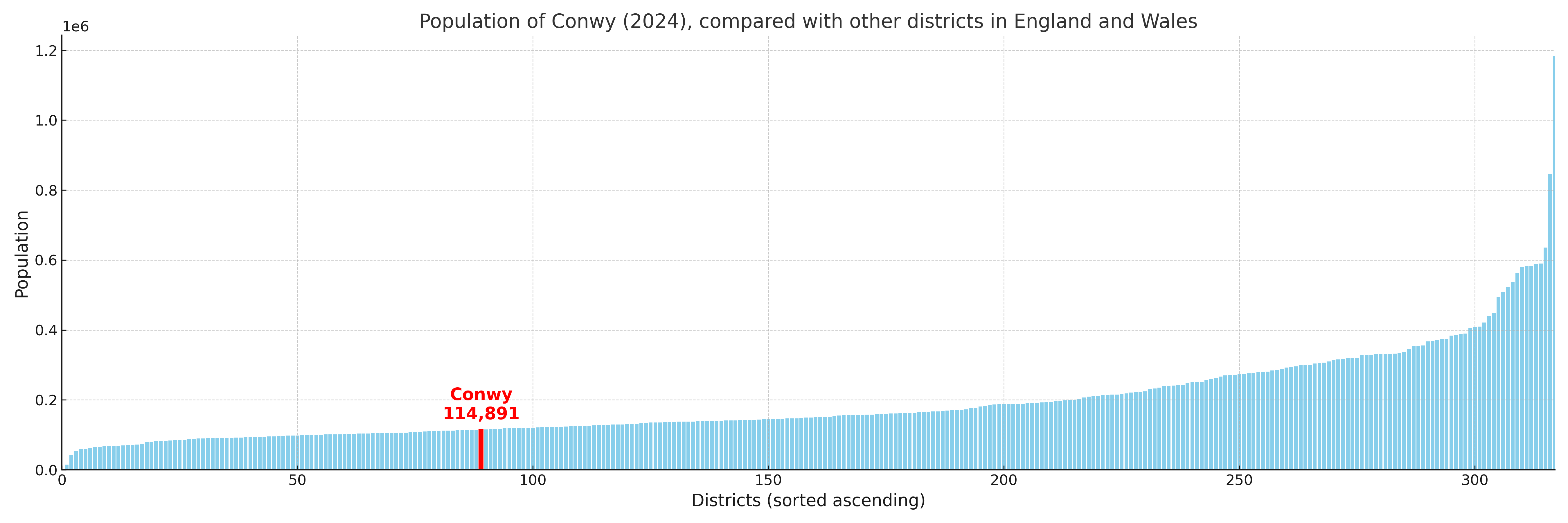
Conwy has a population of 114,891 (2024 mid-year estimate by ONS)
More local statistics and data for Conwy can be found on the ONS statistics for Conwy.
Latest news about Conwy
Use the search box, or suggested search phrases, below to find recent news, council updates, planning stories, housing developments, transport changes, public services news, local elections, community issues and other local developments related to Conwy. Results may include coverage from UK national, regional and local news websites, as well as official public-sector and local democracy sources.
- Conwy council
- Conwy planning
- Conwy local elections
- Conwy housing
- Conwy transport
- Conwy regeneration
- Conwy public services