Cardiff
§ This page gives an overview of the Cardiff local authority district, bringing together key facts, maps, and data to help you quickly understand the area. This is one of 361 LAD profiles on Baseview.
Overview ⁞ Cardiff, the capital and largest city of Wales, is a vibrant political, cultural, and economic hub. It boasts attractions like Cardiff Bay, the Principality Stadium, and the National Museum, with a diverse economy centred on government, finance, media, and tourism.
Cardiff Boundary Map
This map shows the official boundary of the Cardiff local authority district, based on the latest geographic data published by the Office for National Statistics (ONS). It provides a clear view of the district’s extent and helps you understand how the area fits within the wider regional and national landscape.
Contains OS data © Crown copyright and database right 2025. Source: Office for National Statistics licensed under the Open Government Licence v3.0.
The administrative boundary of Cardiff can also be viewed on OpenStreetMap: District Boundary of Cardiff.
Key Facts about Cardiff
What region is Cardiff in? Cardiff is in Wales, a statistical region and also a country in United Kingdom.
Is Cardiff a city? Yes, Cardiff is a city. Cardiff holds official city status as one of the 76 designated cities in the UK.
Who governs Cardiff? The local government for this district is: Cardiff Council (Wales City Council).
▶ Official website of Cardiff Council 🔗 cardiff.gov.uk
Which police force covers Cardiff? Policing in Cardiff is provided by South Wales Police 🔗 south-wales.police.uk, which serves 7 local authority districts: Bridgend ⁞ Cardiff ⁞ Merthyr Tydfil ⁞ Neath Port Talbot ⁞ Rhondda Cynon Taf ⁞ Swansea ⁞ Vale of Glamorgan.
Cardiff in International Geographies
In the International Territorial Levels (ITLs) hierarchy, Cardiff is within an ITLs Level 3 area:
- (ITL 1) Wales
- (ITL 2) ⇒ South East Wales
- (ITL 3) ⇒⇒ Cardiff and Vale of Glamorgan
The International Territorial Levels are used by OECD member countries for statistical purposes to classify administrative areas. We have this listable page for easy browsing of ITL names and codes: International Territorial Levels.
Constituencies in Cardiff
Cardiff is divided into 4 parliamentary constituencies, listed below in alphabetical order.
A constituency is a specific geographical area that elects one Member of Parliament (MP) to represent them in the House of Commons. The United Kingdom is divided into 650 parliamentary constituencies, 32 of them are in Wales. We have this list page for easy browsing of all UK parliamentary constituencies: List of Constituencies.
Wards in Cardiff
Cardiff is divided into 28 wards, listed below in alphabetical order.
- Adamsdown
- Butetown
- Caerau
- Canton
- Cathays
- Cyncoed
- Ely
- Fairwater
- Gabalfa
- Grangetown
- Heath
- Lisvane and Thornhill
- Llandaff
- Llandaff North
- Llanishen
- Llanrumney
- Pentwyn
- Pentyrch and St Fagans
- Penylan
- Plasnewydd
- Pontprennau and Old St Mellons
- Radyr
- Rhiwbina
- Riverside
- Rumney
- Splott
- Trowbridge
- Whitchurch and Tongwynlais
In the UK, a ward is a subdivision of a local authority area, used mainly for electoral and statistical purposes. Defined by the ONS, wards represent the primary unit for local elections, each returning one or more councillors to the local council. Wards are also used as a key geography for presenting population and census data. We have this list page for easy browsing of all electoral wards: List of all Electoral Wards in the UK.
Communities in Cardiff
Cardiff has 36 communities, listed below in alphabetical order.
- Adamsdown
- Butetown
- Caerau
- Canton
- Castle
- Cathays
- Cyncoed
- Ely
- Fairwater
- Gabalfa
- Grangetown
- Heath
- Lisvane
- Llandaff
- Llandaff North
- Llanedeyrn
- Llanishen
- Llanrumney
- Old St. Mellons
- Pentwyn
- Pentyrch
- Penylan
- Pontcanna
- Pontprennau
- Radyr and Morganstown
- Rhiwbina
- Riverside
- Roath
- Rumney
- Splott
- St. Fagans
- Thornhill
- Tongwynlais
- Tremorfa
- Trowbridge
- Whitchurch
In Wales, communities are the Welsh equivalent of civil parishes—the lowest tier of local government. Every part of Wales lies within a community, though only some have an elected community or town council. Where they exist, these councils handle very local matters and speak for residents to the county or county borough council. Like English civil parishes, communities are purely civil/administrative and are distinct from church parishes.
Post Towns in Cardiff
Below is a list of post towns in Cardiff, grouped by postcode area:
CF ▸ Cardiff (CF3 / CF5 / CF10 / CF11 / CF14 / CF15 / CF23 / CF24 / CF30 / CF91 / CF95 / CF99)
The UK postal hierarchy begins with broad postcode areas (such as “CB” or “M”), which are divided into smaller postcode districts (such as “CB8” or “M1”) to support accurate mail routing. Each postal address is anchored by a designated post town, the official locality name used in the UK postcode system, which operates independently from Local Authority Districts —the administrative boundaries used for council tax and local government services. Because they serve different purposes, a property’s postal address and its local authority district do not always align exactly.
Built-up Areas in Cardiff
Cardiff covers 11 built-up areas, listed below in alphabetical order.
- Broadstreet Common *
- Caerphilly *
- Cardiff *
- Creigiau
- Groes-faen *
- Penarth *
- Pentyrch
- St Fagans *
- St Fagans *
- Taff's Well *
- Tongwynlais
In the UK, a Built-up Area (BUA) is a continuous urban area of at least 20 hectares (0.2 km²), defined by the ONS as land where buildings are generally no more than 200 metres apart, such as towns, cities, or large villages. (Note: A BUA name marked with an asterisk (*) indicates that the area is situated partly in the district of Cardiff.)
We have this list page for easy browsing of all built-up areas: List of all Built-up Areas in GB.
Railway Stations in Cardiff
Cardiff is served by a number of National Rail stations, providing rail connections to nearby towns, cities, and destinations across Great Britain. The railway stations listed below are located within the Cardiff Local Authority District and are grouped by train operating company for clarity.
- TfW Rail ▸ Cardiff Central (CF10 1EP) ⁞ Cardiff Queen Street (CF10 4EY) ⁞ Cathays (CF10 3LU) ⁞ Cardiff Bay (CF10 5LE) ⁞ Radyr (CF4 8AA) ⁞ Llandaf (CF14 2FG) ⁞ Heath High Level (CF23 5QT) ⁞ Grangetown (Cardiff) (CF11 8UY) ⁞ Lisvane and Thornhill (CF14 0UE) ⁞ Llanishen (CF14 5UW) ⁞ Ninian Park (CF11 8AH) ⁞ Waun-gron Park (CF5 2BN) ⁞ Fairwater (CF5 3QE) ⁞ Ty Glas (CF14 5DL) ⁞ Danescourt (CF5 2RX) ⁞ Rhiwbina (CF14 6EP) ⁞ Coryton (CF14 7BW) ⁞ Birchgrove (CF14 4SY) ⁞ Heath Low Level (CF23 5QT) ⁞ Whitchurch (Cardiff) (CF14 1BP)
This is a district-level view only. For a complete list of all National Rail stations across Great Britain, see the UK National Rail Stations Directory.
Cardiff compared with other districts in the UK
This section shows how Cardiff compares with other local authority districts in the UK, using a variety of measures and rankings.
Cardiff has 28 electoral wards.

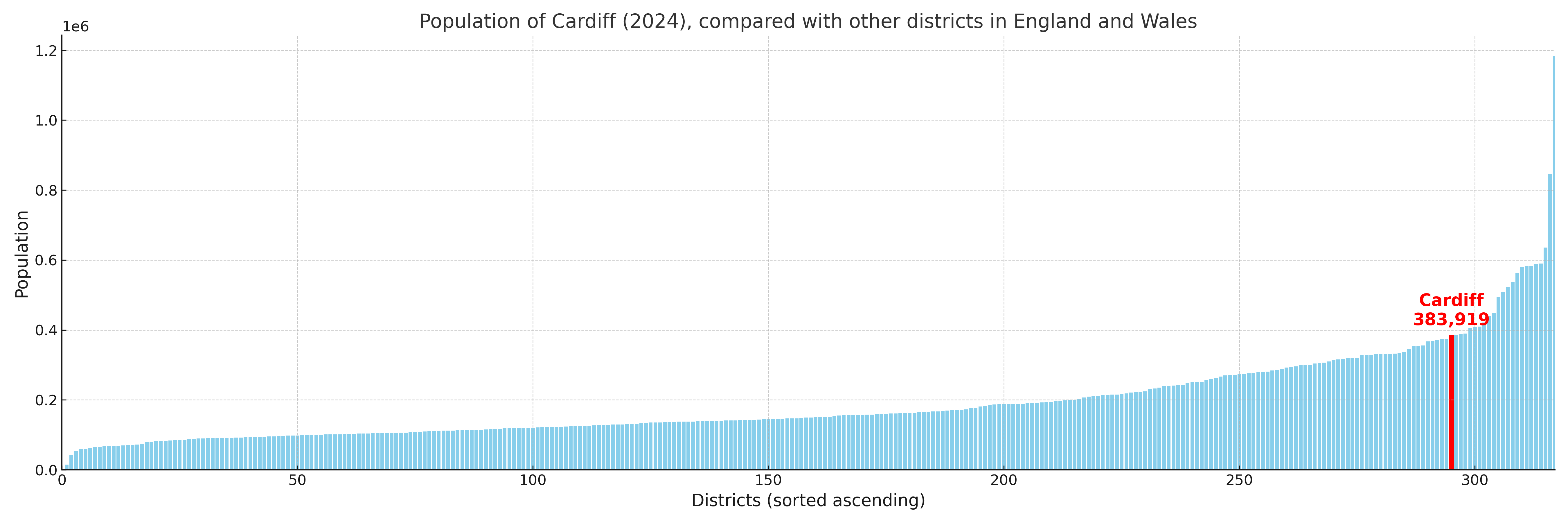
Cardiff has a population of 383,919 (2024 mid-year estimate by ONS)
More local statistics and data for Cardiff can be found on the ONS statistics for Cardiff.
Latest news about Cardiff
Use the search box, or suggested search phrases, below to find recent news, council updates, planning stories, housing developments, transport changes, public services news, local elections, community issues and other local developments related to Cardiff. Results may include coverage from UK national, regional and local news websites, as well as official public-sector and local democracy sources.
- Cardiff council
- Cardiff planning
- Cardiff local elections
- Cardiff housing
- Cardiff transport
- Cardiff regeneration
- Cardiff public services