Denbighshire
§ This page gives an overview of the Denbighshire local authority district, bringing together key facts, maps, and data to help you quickly understand the area. This is one of 361 LAD profiles on Baseview.
Overview ⁞ Denbighshire runs from the Irish Sea coast into the Clwydian Range and Dee Valley. Towns include Rhyl, Prestatyn, and Denbigh, and the area blends tourism, agriculture, and light industry with scenic landscapes and historic sites.
Denbighshire Boundary Map
This map shows the official boundary of the Denbighshire local authority district, based on the latest geographic data published by the Office for National Statistics (ONS). It provides a clear view of the district’s extent and helps you understand how the area fits within the wider regional and national landscape.
Contains OS data © Crown copyright and database right 2025. Source: Office for National Statistics licensed under the Open Government Licence v3.0.
The administrative boundary of Denbighshire can also be viewed on OpenStreetMap: District Boundary of Denbighshire.
Key Facts about Denbighshire
What region is Denbighshire in? Denbighshire is in Wales, a statistical region and also a country in United Kingdom.
Is Denbighshire a city? Yes, Denbighshire is a city. Denbighshire holds official city status as one of the 76 designated cities in the UK.
Who governs Denbighshire? The local government for this district is: Denbighshire County Council (Wales County Council).
▶ Official website of Denbighshire County Council 🔗 denbighshire.gov.uk
Which police force covers Denbighshire? Policing in Denbighshire is provided by North Wales Police 🔗 northwales.police.uk, which serves 6 local authority districts: Conwy ⁞ Denbighshire ⁞ Flintshire ⁞ Gwynedd ⁞ Isle of Anglesey ⁞ Wrexham.
Denbighshire in International Geographies
In the International Territorial Levels (ITLs) hierarchy, Denbighshire is within an ITLs Level 3 area:
- (ITL 1) Wales
- (ITL 2) ⇒ North Wales
- (ITL 3) ⇒⇒ Conwy and Denbighshire
The International Territorial Levels are used by OECD member countries for statistical purposes to classify administrative areas. We have this listable page for easy browsing of ITL names and codes: International Territorial Levels.
Constituencies in Denbighshire
Denbighshire is divided into 4 parliamentary constituencies, listed below in alphabetical order.
A constituency is a specific geographical area that elects one Member of Parliament (MP) to represent them in the House of Commons. The United Kingdom is divided into 650 parliamentary constituencies, 32 of them are in Wales. We have this list page for easy browsing of all UK parliamentary constituencies: List of Constituencies.
Wards in Denbighshire
Denbighshire is divided into 29 wards, listed below in alphabetical order.
- Alyn Valley
- Bodelwyddan
- Denbigh Caledfryn Henllan
- Denbigh Lower
- Dyserth
- Edeirnion
- Efenechdyd
- Llandyrnog
- Llanfair Dyffryn Clwyd Gwyddelwern
- Llangollen
- Llanrhaeadr-yng-Nghinmeirch
- Moel Famau
- Prestatyn Central
- Prestatyn East
- Prestatyn Meliden
- Prestatyn North
- Prestatyn South West
- Rhuddlan
- Rhyl East
- Rhyl South
- Rhyl South West
- Rhyl Trellewelyn
- Rhyl Ty Newydd
- Rhyl West
- Ruthin
- St Asaph East
- St Asaph West
- Trefnant
- Tremeirchion
In the UK, a ward is a subdivision of a local authority area, used mainly for electoral and statistical purposes. Defined by the ONS, wards represent the primary unit for local elections, each returning one or more councillors to the local council. Wards are also used as a key geography for presenting population and census data. We have this list page for easy browsing of all electoral wards: List of all Electoral Wards in the UK.
Communities in Denbighshire
Denbighshire has 39 communities, listed below in alphabetical order.
- Aberwheeler
- Betws Gwerfil Goch
- Bodelwyddan
- Bodfari
- Bryneglwys
- Cefnmeiriadog
- Clocaenog
- Corwen
- Cwm
- Cyffylliog
- Cynwyd
- Denbigh
- Derwen
- Dyserth
- Efenechtyd
- Gwyddelwern
- Henllan
- Llanarmon-yn-Ial
- Llanbedr Dyffryn Clwyd
- Llandegla
- Llandrillo
- Llandyrnog
- Llanelidan
- Llanfair Dyffryn Clwyd
- Llanferres
- Llangollen
- Llangynhafal
- Llanrhaeadr-yng-Nghinmeirch
- Llantysilio
- Llanynys
- Nantglyn
- Prestatyn
- Rhuddlan
- Rhyl
- Ruthin
- St. Asaph
- Trefnant
- Tremeirchion
- Waen
In Wales, communities are the Welsh equivalent of civil parishes—the lowest tier of local government. Every part of Wales lies within a community, though only some have an elected community or town council. Where they exist, these councils handle very local matters and speak for residents to the county or county borough council. Like English civil parishes, communities are purely civil/administrative and are distinct from church parishes.
Post Towns in Denbighshire
Below is a list of post towns in Denbighshire, grouped by postcode area:
- LL ▸ Corwen (LL21) ⁞ Denbigh (LL16) ⁞ Llangollen (LL20) ⁞ Prestatyn (LL19) ⁞ Rhyl (LL18) ⁞ Ruthin (LL15) ⁞ St. Asaph (LL17 / LL18)
The UK postal hierarchy begins with broad postcode areas (such as “CB” or “M”), which are divided into smaller postcode districts (such as “CB8” or “M1”) to support accurate mail routing. Each postal address is anchored by a designated post town, the official locality name used in the UK postcode system, which operates independently from Local Authority Districts —the administrative boundaries used for council tax and local government services. Because they serve different purposes, a property’s postal address and its local authority district do not always align exactly.
Built-up Areas in Denbighshire
Denbighshire covers 21 built-up areas, listed below in alphabetical order.
- Bodelwyddan
- Clawdd Poncen
- Corwen
- Cynwyd
- Denbigh
- Dyserth
- Gronant *
- Gwernymynydd *
- Gwespyr *
- Henllan
- Kinmel Bay *
- Llangollen
- Meliden
- Nant-y-Patrick
- Prestatyn *
- Rhuddlan
- Rhyl
- Ruthin
- St Asaph
- Trefnant
- Trevor *
In the UK, a Built-up Area (BUA) is a continuous urban area of at least 20 hectares (0.2 km²), defined by the ONS as land where buildings are generally no more than 200 metres apart, such as towns, cities, or large villages. (Note: A BUA name marked with an asterisk (*) indicates that the area is situated partly in the district of Denbighshire.)
We have this list page for easy browsing of all built-up areas: List of all Built-up Areas in GB.
Railway Stations in Denbighshire
Denbighshire is served by a number of National Rail stations, providing rail connections to nearby towns, cities, and destinations across Great Britain. The railway stations listed below are located within the Denbighshire Local Authority District and are grouped by train operating company for clarity.
- TfW Rail ▸ Rhyl (LL18 1AT) ⁞ Prestatyn (LL19 7ER)
This is a district-level view only. For a complete list of all National Rail stations across Great Britain, see the UK National Rail Stations Directory.
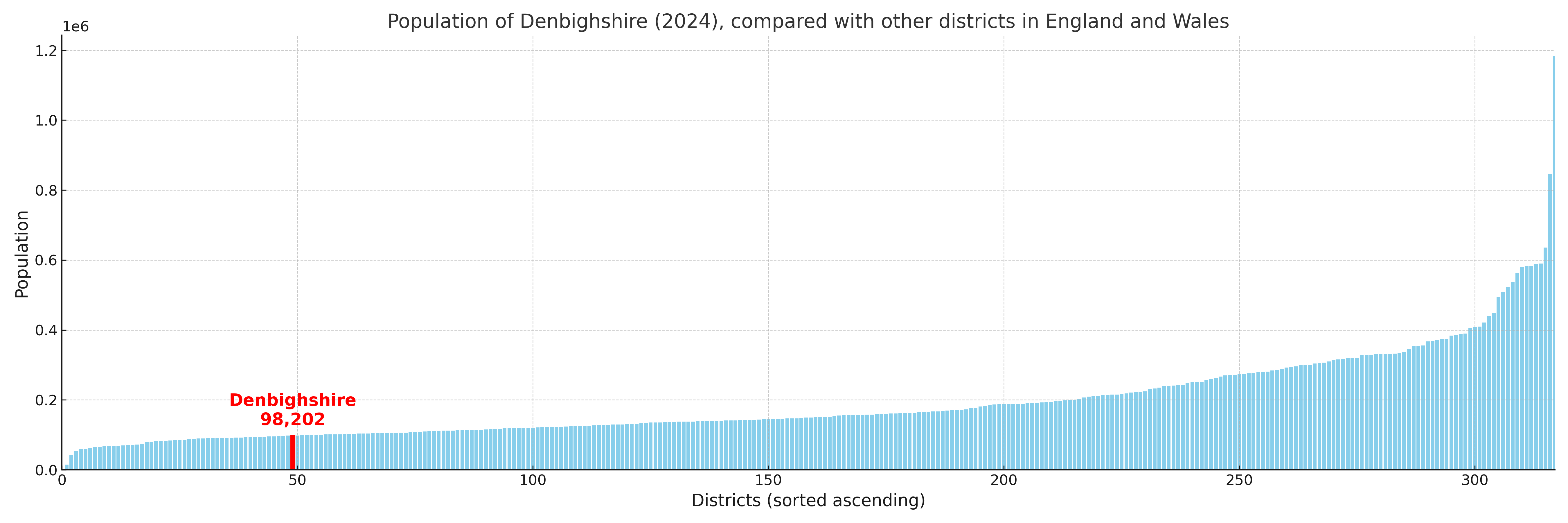
Denbighshire compared with other districts in the UK
This section shows how Denbighshire compares with other local authority districts in the UK, using a variety of measures and rankings.
Denbighshire has 29 electoral wards.

Denbighshire has a population of 98,202 (2024 mid-year estimate by ONS)
More local statistics and data for Denbighshire can be found on the ONS statistics for Denbighshire.
Latest news about Denbighshire
Use the search box, or suggested search phrases, below to find recent news, council updates, planning stories, housing developments, transport changes, public services news, local elections, community issues and other local developments related to Denbighshire. Results may include coverage from UK national, regional and local news websites, as well as official public-sector and local democracy sources.
- Denbighshire council
- Denbighshire planning
- Denbighshire local elections
- Denbighshire housing
- Denbighshire transport
- Denbighshire regeneration
- Denbighshire public services