Warrington
§ This page gives an overview of the Warrington local authority district, bringing together key facts, maps, and data to help you quickly understand the area. This is one of 361 LAD profiles on Baseview.
Overview ⁞ Warrington, in Cheshire, is located on the River Mersey and the Manchester Ship Canal, with a town centre known for its historic market, cultural venues, and modern shopping areas. Its position as a transport hub is reflected in the canals and waterways crossing the district. Parks and countryside, including Sankey Valley Park and Lymm Dam, offer green escapes, while villages such as Lymm and Grappenhall add historic charm with their stone buildings and canalside pubs. Warrington blends a thriving town with riverside and rural surroundings.
Warrington Boundary Map
This map shows the official boundary of the Warrington local authority district, based on the latest geographic data published by the Office for National Statistics (ONS). It provides a clear view of the district’s extent and helps you understand how the area fits within the wider regional and national landscape.
Contains OS data © Crown copyright and database right 2025. Source: Office for National Statistics licensed under the Open Government Licence v3.0.
The administrative boundary of Warrington can also be viewed on OpenStreetMap: District Boundary of Warrington.
Key Facts about Warrington
What region is Warrington in? Warrington is in the North West of England, a region within the UK.
What county is Warrington in? Warrington is in the county of Cheshire.
Is Warrington a city? No, Warrington is not a city. (Note: the UK has 76 officially designated cities.)
Who governs Warrington? The local government for this district is: Warrington Borough Council (Unitary Authority).
▶ Official website of Warrington Borough Council 🔗 warrington.gov.uk
Which police force covers Warrington? Policing in Warrington is provided by Cheshire Constabulary 🔗 cheshire.police.uk, which serves 4 local authority districts: Cheshire East ⁞ Cheshire West and Chester ⁞ Halton ⁞ Warrington.
Warrington in International Geographies
In the International Territorial Levels (ITLs) hierarchy, Warrington is an ITLs Level 3 area:
- (ITL 1) North West
- (ITL 2) ⇒ Cheshire
- (ITL 3) ⇒⇒ Warrington
The International Territorial Levels are used by OECD member countries for statistical purposes to classify administrative areas. We have this listable page for easy browsing of ITL names and codes: International Territorial Levels.
Constituencies in Warrington
Warrington is divided into 3 parliamentary constituencies, listed below in alphabetical order.
A constituency is a specific geographical area that elects one Member of Parliament (MP) to represent them in the House of Commons. The United Kingdom is divided into 650 parliamentary constituencies. We have this list page for easy browsing of all UK parliamentary constituencies: List of Constituencies.
Wards in Warrington
Warrington is divided into 22 wards, listed below in alphabetical order.
- Appleton
- Bewsey and Whitecross
- Birchwood
- Burtonwood and Winwick
- Chapelford and Old Hall
- Culcheth, Glazebury and Croft
- Fairfield and Howley
- Grappenhall
- Great Sankey North and Whittle Hall
- Great Sankey South
- Latchford East
- Latchford West
- Lymm North and Thelwall
- Lymm South
- Orford
- Penketh and Cuerdley
- Poplars and Hulme
- Poulton North
- Poulton South
- Rixton and Woolston
- Stockton Heath
- Westbrook
In the UK, a ward is a subdivision of a local authority area, used mainly for electoral and statistical purposes. Defined by the ONS, wards represent the primary unit for local elections, each returning one or more councillors to the local council. Wards are also used as a key geography for presenting population and census data. We have this list page for easy browsing of all electoral wards: List of all Electoral Wards in the UK.
Parishes in Warrington
Warrington is part-parished: 18 civil parishes (listed A-Z below) alongside 3 unparished areas.
- Appleton
- Birchwood
- Burtonwood and Westbrook
- Croft
- Cuerdley
- Culcheth and Glazebury
- Grappenhall and Thelwall
- Great Sankey
- Hatton
- Lymm
- Penketh
- Poulton-with-Fearnhead
- Rixton-with-Glazebrook
- Stockton Heath
- Stretton
- Walton
- Winwick
- Woolston
A civil parish is the lowest tier of local government in England, used for villages, small towns, and suburbs. They have their own local authority, either a parish council or a parish meeting, which provides local services like managing parks, allotments, and streetlights, and represents the community's views to larger councils.
We have this list page for easy browsing of all parishes: List of Civil Parishes in England and Wales.
Post Towns in Warrington
Below is a list of post towns in Warrington, grouped by postcode area:
- WA ▸ Lymm (WA13) ⁞ Warrington (WA1 / WA2 / WA3 / WA4 / WA5 / WA55)
The UK postal hierarchy begins with broad postcode areas (such as “CB” or “M”), which are divided into smaller postcode districts (such as “CB8” or “M1”) to support accurate mail routing. Each postal address is anchored by a designated post town, the official locality name used in the UK postcode system, which operates independently from Local Authority Districts —the administrative boundaries used for council tax and local government services. Because they serve different purposes, a property’s postal address and its local authority district do not always align exactly.
Built-up Areas in Warrington
Warrington covers 15 built-up areas, listed below in alphabetical order.
- Appleton Thorn *
- Burtonwood *
- Croft (Warrington)
- Culcheth
- Fowley Common
- Glazebury *
- Hollinfare
- Irlam *
- Lymm *
- Moore *
- Newton-le-Willows *
- St Helens (St. Helens) *
- Warrington *
- Widnes *
- Winwick
In the UK, a Built-up Area (BUA) is a continuous urban area of at least 20 hectares (0.2 km²), defined by the ONS as land where buildings are generally no more than 200 metres apart, such as towns, cities, or large villages. (Note: A BUA name marked with an asterisk (*) indicates that the area is situated partly in the district of Warrington.)
We have this list page for easy browsing of all built-up areas: List of all Built-up Areas in GB.
Railway Stations in Warrington
Warrington is served by a number of National Rail stations, providing rail connections to nearby towns, cities, and destinations across Great Britain. The railway stations listed below are located within the Warrington Local Authority District and are grouped by train operating company for clarity.
- Avanti West Coast ▸ Warrington Bank Quay (WA1 1LW)
- Northern Trains ▸ Warrington Central (WA2 7TT) ⁞ Birchwood (WA3 7PU) ⁞ Warrington West (WA5 8SA) ⁞ Padgate (WA2 0QS) ⁞ Glazebrook (WA3 5BA) ⁞ Sankey For Penketh (WA5 1RQ)
This is a district-level view only. For a complete list of all National Rail stations across Great Britain, see the UK National Rail Stations Directory.
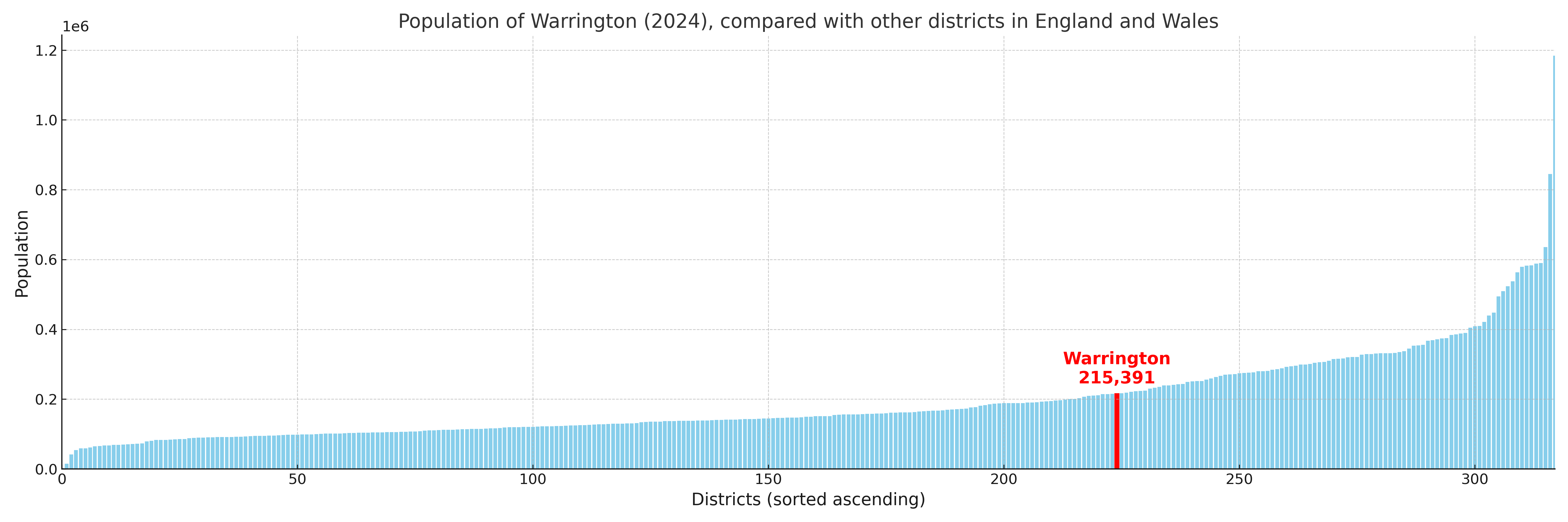
Warrington compared with other districts in the UK
This section shows how Warrington compares with other local authority districts in the UK, using a variety of measures and rankings.
Warrington has 22 electoral wards.

Warrington has a population of 215,391 (2024 mid-year estimate by ONS)
Population and Migration Trends in Warrington
This chart shows the population trend for Warrington from 2015 to 2024. It provides a quick overview of whether the local authority is growing, stable, or declining over time, and helps set context for the migration patterns shown below.
Population change is influenced by natural change (births minus deaths) and migration. The net migration chart below focuses on migration, separating internal migration (moves within the UK) from international migration (moves to and from abroad). Positive values indicate net inflows, while negative values indicate net outflows. The rate labels (per 1,000 residents) help compare migration intensity across years, even when the population size changes.
More local statistics and data for Warrington can be found on the ONS statistics for Warrington.
Latest news about Warrington
Use the search box, or suggested search phrases, below to find recent news, council updates, planning stories, housing developments, transport changes, public services news, local elections, community issues and other local developments related to Warrington. Results may include coverage from UK national, regional and local news websites, as well as official public-sector and local democracy sources.
- Warrington council
- Warrington planning
- Warrington local elections
- Warrington housing
- Warrington transport
- Warrington regeneration
- Warrington public services