Cheshire West and Chester
§ This page gives an overview of the Cheshire West and Chester local authority district, bringing together key facts, maps, and data to help you quickly understand the area. This is one of 361 LAD profiles on Baseview.
Overview ⁞ Cheshire West and Chester includes the historic city of Chester, with its Roman walls, cathedral, and famous Rows of medieval shopping galleries. The district stretches to the Wirral Peninsula and the Welsh border, with towns such as Northwich, Ellesmere Port, and Winsford. Countryside landscapes include the Cheshire Plain, forests, and canals, while the River Dee flows through Chester and its scenic valley. Landmarks such as Delamere Forest, Anderton Boat Lift, and Cheshire Oaks add cultural and leisure attractions, blending heritage with natural scenery.
Cheshire West and Chester Boundary Map
This map shows the official boundary of the Cheshire West and Chester local authority district, based on the latest geographic data published by the Office for National Statistics (ONS). It provides a clear view of the district’s extent and helps you understand how the area fits within the wider regional and national landscape.
Contains OS data © Crown copyright and database right 2025. Source: Office for National Statistics licensed under the Open Government Licence v3.0.
The administrative boundary of Cheshire West and Chester can also be viewed on OpenStreetMap: District Boundary of Cheshire West and Chester.
Key Facts about Cheshire West and Chester
What region are Cheshire West and Chester in? Cheshire West and Chester are in the North West of England, a region within the UK.
What county is Cheshire West and Chester in? Cheshire West and Chester is in the county of Cheshire.
Is Cheshire West and Chester a city? Yes, Cheshire West and Chester is a city. Cheshire West and Chester holds official city status as one of the 76 designated cities in the UK.
Who governs Cheshire West and Chester? The local government for this district is: Cheshire West and Chester Council (Unitary Authority).
▶ Official website of Cheshire West and Chester Council 🔗 cheshirewestandchester.gov.uk
Which police force covers Cheshire West and Chester? Policing in Cheshire West and Chester is provided by Cheshire Constabulary 🔗 cheshire.police.uk, which serves 4 local authority districts: Cheshire East ⁞ Cheshire West and Chester ⁞ Halton ⁞ Warrington.
Cheshire West and Chester in International Geographies
In the International Territorial Levels (ITLs) hierarchy, Cheshire West and Chester is an ITLs Level 3 area:
- (ITL 1) North West
- (ITL 2) ⇒ Cheshire
- (ITL 3) ⇒⇒ Cheshire West and Chester
The International Territorial Levels are used by OECD member countries for statistical purposes to classify administrative areas. We have this listable page for easy browsing of ITL names and codes: International Territorial Levels.
Constituencies in Cheshire West and Chester
Cheshire West and Chester is divided into 6 parliamentary constituencies, listed below in alphabetical order.
- Chester North and Neston
- Chester South and Eddisbury
- Ellesmere Port and Bromborough
- Mid Cheshire
- Runcorn and Helsby
- Tatton
A constituency is a specific geographical area that elects one Member of Parliament (MP) to represent them in the House of Commons. The United Kingdom is divided into 650 parliamentary constituencies. We have this list page for easy browsing of all UK parliamentary constituencies: List of Constituencies.
Wards in Cheshire West and Chester
Cheshire West and Chester is divided into 45 wards, listed below in alphabetical order.
- Blacon
- Central & Grange
- Chester City & the Garden Quarter
- Christleton & Huntington
- Davenham, Moulton & Kingsmead
- Farndon
- Frodsham
- Gowy Rural
- Great Boughton
- Handbridge Park
- Hartford & Greenbank
- Helsby
- Lache
- Ledsham & Manor
- Little Neston
- Malpas
- Marbury
- Neston
- Netherpool
- Newton & Hoole
- Northwich Leftwich
- Northwich Winnington & Castle
- Northwich Witton
- Parkgate
- Rudheath
- Sandstone
- Saughall & Mollington
- Shakerley
- Strawberry
- Sutton Villages
- Tarporley
- Tarvin & Kelsall
- Tattenhall
- Upton
- Weaver & Cuddington
- Westminster
- Whitby Groves
- Whitby Park
- Willaston & Thornton
- Winsford Dene
- Winsford Gravel
- Winsford Over & Verdin
- Winsford Swanlow
- Winsford Wharton
- Wolverham
In the UK, a ward is a subdivision of a local authority area, used mainly for electoral and statistical purposes. Defined by the ONS, wards represent the primary unit for local elections, each returning one or more councillors to the local council. Wards are also used as a key geography for presenting population and census data. We have this list page for easy browsing of all electoral wards: List of all Electoral Wards in the UK.
Parishes in Cheshire West and Chester
Cheshire West and Chester is part-parished: 114 civil parishes (listed A-Z below) alongside 4 unparished areas.
- Acton Bridge
- Agden
- Aldersey
- Aldford and Saighton
- Allostock
- Alvanley
- Anderton with Marbury
- Antrobus
- Ashton Hayes and Horton-cum-Peel
- Aston
- Bache
- Backford
- Barnton
- Barrow
- Barton
- Beeston
- Bostock
- Broxton
- Burwardsley
- Byley
- Capenhurst
- Carden
- Chester Castle
- Chidlow
- Chorlton
- Chowley
- Christleton
- Churton
- Clotton Hoofield
- Clutton
- Coddington
- Comberbach
- Croughton
- Crowton
- Cuddington (Malpas Ward)
- Cuddington (Weaver and Cuddington Ward)
- Darnhall
- Davenham
- Delamere and Oakmere
- Dodleston
- Duckington
- Duddon and Burton
- Dunham-on-the-Hill and Hapsford
- Dutton
- Eaton and Eccleston
- Elton
- Farndon
- Frodsham
- Golborne David
- Great Boughton
- Great Budworth
- Guilden Sutton
- Handley
- Hargrave and Huxley
- Hartford
- Harthill
- Helsby
- Huntington
- Ince
- Kelsall
- Kingsley
- Kingsmead
- Lach Dennis and Lostock Green
- Lea-by-Backford
- Ledsham
- Little Budworth
- Little Leigh
- Little Stanney
- Littleton
- Lostock Gralam
- Malpas
- Manley
- Marston
- Mickle Trafford and District
- Mollington
- Moston
- Mouldsworth
- Moulton
- Neston
- Nether Peover
- No Man's Heath and District
- Norley
- Northwich
- Poulton and Pulford
- Puddington
- Rowton
- Rudheath
- Rushton
- Saughall and Shotwick Park
- Shocklach Oviatt and District
- Sproston
- Stanthorne and Wimboldsley
- Stoak
- Stretton
- Sutton Weaver
- Tarporley
- Tarvin
- Tattenhall and District
- Thornton-le-Moors
- Threapwood
- Tilston
- Tiverton and Tilstone Fearnall
- Tushingham-cum-Grindley, Macefen and Bradley
- Upton-by-Chester
- Utkinton and Cotebrook
- Waverton
- Weaverham
- Wervin
- Whitegate and Marton
- Whitley
- Wigland
- Willington
- Wincham
- Winsford
A civil parish is the lowest tier of local government in England, used for villages, small towns, and suburbs. They have their own local authority, either a parish council or a parish meeting, which provides local services like managing parks, allotments, and streetlights, and represents the community's views to larger councils.
We have this list page for easy browsing of all parishes: List of Civil Parishes in England and Wales.
Post Towns in Cheshire West and Chester
Below is a list of post towns in Cheshire West and Chester, grouped by postcode area:
- CH ▸ Chester (CH1 / CH2 / CH3 / CH4 / CH70 / CH88 / CH99) ⁞ Ellesmere Port (CH34 / CH65 / CH66) ⁞ Neston (CH33 / CH64)
- CW ▸ Northwich (CW8 / CW9) ⁞ Tarporley (CW6) ⁞ Winsford (CW7)
- SY ▸ Malpas (SY14)
- WA ▸ Frodsham (WA6)
The UK postal hierarchy begins with broad postcode areas (such as “CB” or “M”), which are divided into smaller postcode districts (such as “CB8” or “M1”) to support accurate mail routing. Each postal address is anchored by a designated post town, the official locality name used in the UK postcode system, which operates independently from Local Authority Districts —the administrative boundaries used for council tax and local government services. Because they serve different purposes, a property’s postal address and its local authority district do not always align exactly.
Built-up Areas in Cheshire West and Chester
Cheshire West and Chester covers 70 built-up areas, listed below in alphabetical order.
- Acton Bridge
- Allostock
- Ashton Hayes
- Barnton
- Bebington *
- Boothsdale
- Brown Knowl *
- Bunbury *
- Burton (Cheshire West and Chester)
- Byley
- Capenhurst
- Chester *
- Childer Thornton
- Christleton and Waverton
- Churton
- Clotton
- Comberbach
- Cotebrook
- Cuddington (Cheshire West and Chester)
- Davenham
- Delamere
- Dodleston
- Duddon
- Dunham-on-the-Hill
- Ellesmere Port *
- Elton (Cheshire West and Chester)
- Farndon (Cheshire West and Chester)
- Frodsham
- Goostrey *
- Great Barrow
- Guilden Sutton
- Hartford
- Helsby
- Heswall *
- Holt (Wrexham) *
- Hooton
- Kelsall
- Kingsley (Cheshire West and Chester)
- Lach Dennis
- Littleton (Cheshire West and Chester)
- Lostock Gralam
- Lower Peover *
- Malpas
- Mickle Trafford
- Middlewich *
- Mollington (Cheshire West and Chester)
- Moston
- Mouldsworth
- Neston (Cheshire West and Chester) *
- No Man's Heath
- Norley
- Northwich
- Pickmere *
- Rudheath
- Rudheath Woods *
- Runcorn *
- Saughall
- Tallarn Green *
- Tarporley
- Tarvin
- Tattenhall
- Threapwood *
- Tilston
- Utkinton
- Weaverham
- Whitegate
- Willaston (Cheshire West and Chester)
- Wincham and Marston
- Windle Hill
- Winsford
In the UK, a Built-up Area (BUA) is a continuous urban area of at least 20 hectares (0.2 km²), defined by the ONS as land where buildings are generally no more than 200 metres apart, such as towns, cities, or large villages. (Note: A BUA name marked with an asterisk (*) indicates that the area is situated partly in the district of Cheshire West and Chester.)
We have this list page for easy browsing of all built-up areas: List of all Built-up Areas in GB.
Railway Stations in Cheshire West and Chester
Cheshire West and Chester is served by a number of National Rail stations, providing rail connections to nearby towns, cities, and destinations across Great Britain. The railway stations listed below are located within the Cheshire West and Chester Local Authority District and are grouped by train operating company for clarity.
- Merseyrail ▸ Hooton (CH66 7NL) ⁞ Ellesmere Port (CH65 4AR) ⁞ Bache (CH2 1BS) ⁞ Overpool (CH66 3LW) ⁞ Capenhurst (CH1 6HE) ⁞ Little Sutton (CH66 1PA)
- Northern Trains ▸ Greenbank (CW9 7NJ) ⁞ Northwich (CW9 5LY) ⁞ Cuddington (CW8 2LE) ⁞ Lostock Gralam (CW9 7NU) ⁞ Delamere (CW8 2HZ) ⁞ Mouldsworth (WA6 9EG) ⁞ Ince and Elton (Cheshire) (CH2 4NG) ⁞ Stanlow and Thornton (CH2 4NU)
- TfW Rail ▸ Chester (CH1 3NS) ⁞ Frodsham (WA6 7DN) ⁞ Helsby (WA6 0AE) ⁞ Neston (CH64 9SR)
- West Midlands Trains (London Northwestern Railway) ▸ Hartford (Cheshire) (CW8 1QX) ⁞ Winsford (CW7 3NF) ⁞ Acton Bridge (Cheshire) (CW8 2RE)
This is a district-level view only. For a complete list of all National Rail stations across Great Britain, see the UK National Rail Stations Directory.
Cheshire West and Chester compared with other districts in the UK
This section shows how Cheshire West and Chester compares with other local authority districts in the UK, using a variety of measures and rankings.
Cheshire West and Chester has 45 electoral wards.

Cheshire West and Chester has a population of 371,652 (2024 mid-year estimate by ONS)
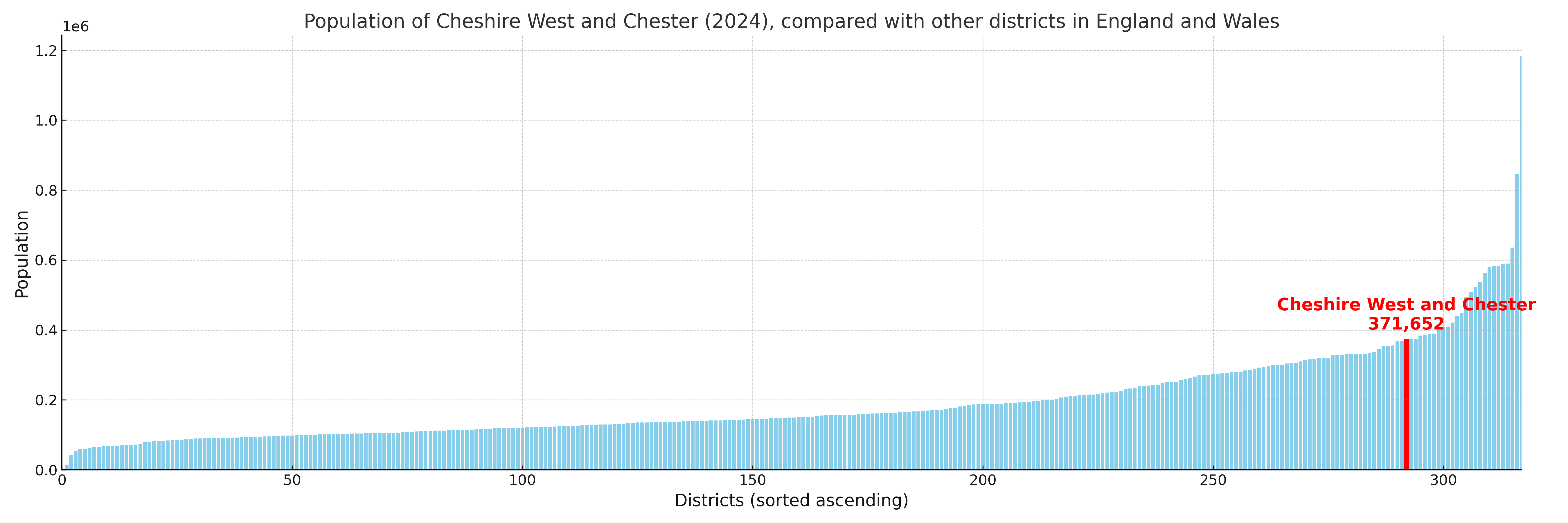
Population and Migration Trends in Cheshire West and Chester
This chart shows the population trend for Cheshire West and Chester from 2015 to 2024. It provides a quick overview of whether the local authority is growing, stable, or declining over time, and helps set context for the migration patterns shown below.
Population change is influenced by natural change (births minus deaths) and migration. The net migration chart below focuses on migration, separating internal migration (moves within the UK) from international migration (moves to and from abroad). Positive values indicate net inflows, while negative values indicate net outflows. The rate labels (per 1,000 residents) help compare migration intensity across years, even when the population size changes.
More local statistics and data for Cheshire West and Chester can be found on the ONS statistics for Cheshire West and Chester.
Latest news about Cheshire West and Chester
Use the search box, or suggested search phrases, below to find recent news, council updates, planning stories, housing developments, transport changes, public services news, local elections, community issues and other local developments related to Cheshire West and Chester. Results may include coverage from UK national, regional and local news websites, as well as official public-sector and local democracy sources.
- Cheshire West and Chester council
- Cheshire West and Chester planning
- Cheshire West and Chester local elections
- Cheshire West and Chester housing
- Cheshire West and Chester transport
- Cheshire West and Chester regeneration
- Cheshire West and Chester public services