Sefton
§ This page gives an overview of the Sefton local authority district, bringing together key facts, maps, and data to help you quickly understand the area. This is one of 361 LAD profiles on Baseview.
Overview ⁞ Sefton stretches along the Merseyside coast, from the resorts of Southport to the industrial docks of Bootle. Southport is a Victorian seaside town with a pier, marine lake, and extensive sand dunes, while Crosby is known for Antony Gormley’s “Another Place” sculptures on the beach. The Sefton Coast includes nature reserves, pine woodlands, and dune systems rich in wildlife. Inland towns such as Maghull and Formby add suburban and village character, while the Leeds and Liverpool Canal passes through, linking communities with waterways and green corridors.
Sefton Boundary Map
This map shows the official boundary of the Sefton local authority district, based on the latest geographic data published by the Office for National Statistics (ONS). It provides a clear view of the district’s extent and helps you understand how the area fits within the wider regional and national landscape.
Contains OS data © Crown copyright and database right 2025. Source: Office for National Statistics licensed under the Open Government Licence v3.0.
The administrative boundary of Sefton can also be viewed on OpenStreetMap: District Boundary of Sefton.
Key Facts about Sefton
What region is Sefton in? Sefton is in the North West of England, a region within the UK.
What county is Sefton in? Sefton is located in the county of Merseyside.
Is Sefton a city? No, Sefton is not a city. (Note: the UK has 76 officially designated cities.)
Who governs Sefton? The local government for this district is: Sefton Borough Council (Metropolitan District).
▶ Official website of Sefton Borough Council 🔗 sefton.gov.uk
Which police force covers Sefton? Policing in Sefton is provided by Merseyside Police 🔗 merseyside.police.uk, which serves 5 local authority districts: Knowsley ⁞ Liverpool ⁞ Sefton ⁞ St. Helens ⁞ Wirral.
Sefton in International Geographies
In the International Territorial Levels (ITLs) hierarchy, Sefton is an ITLs Level 3 area:
- (ITL 1) North West
- (ITL 2) ⇒ Merseyside
- (ITL 3) ⇒⇒ Sefton
The International Territorial Levels are used by OECD member countries for statistical purposes to classify administrative areas. We have this listable page for easy browsing of ITL names and codes: International Territorial Levels.
Constituencies in Sefton
Sefton is divided into 4 parliamentary constituencies, listed below in alphabetical order.
A constituency is a specific geographical area that elects one Member of Parliament (MP) to represent them in the House of Commons. The United Kingdom is divided into 650 parliamentary constituencies. We have this list page for easy browsing of all UK parliamentary constituencies: List of Constituencies.
Wards in Sefton
Sefton is divided into 22 wards, listed below in alphabetical order.
- Ainsdale
- Birkdale
- Blundellsands
- Cambridge
- Church
- Derby
- Duke's
- Ford
- Harington
- Kew
- Linacre
- Litherland
- Manor
- Meols
- Molyneux
- Netherton and Orrell
- Norwood
- Park
- Ravenmeols
- St Oswald
- Sudell
- Victoria
In the UK, a ward is a subdivision of a local authority area, used mainly for electoral and statistical purposes. Defined by the ONS, wards represent the primary unit for local elections, each returning one or more councillors to the local council. Wards are also used as a key geography for presenting population and census data. We have this list page for easy browsing of all electoral wards: List of all Electoral Wards in the UK.
Parishes in Sefton
Sefton is part-parished: 10 civil parishes (listed A-Z below) alongside 4 unparished areas.
- Aintree Village
- Formby
- Hightown
- Ince Blundell
- Little Altcar
- Lydiate
- Maghull
- Melling
- Sefton
- Thornton
A civil parish is the lowest tier of local government in England, used for villages, small towns, and suburbs. They have their own local authority, either a parish council or a parish meeting, which provides local services like managing parks, allotments, and streetlights, and represents the community's views to larger councils.
We have this list page for easy browsing of all parishes: List of Civil Parishes in England and Wales.
Post Towns in Sefton
Below is a list of post towns in Sefton, grouped by postcode area:
- L ▸ Bootle (L20 / L30 / L69 / L80)
- PR ▸ Southport (PR8 / PR9)
The UK postal hierarchy begins with broad postcode areas (such as “CB” or “M”), which are divided into smaller postcode districts (such as “CB8” or “M1”) to support accurate mail routing. Each postal address is anchored by a designated post town, the official locality name used in the UK postcode system, which operates independently from Local Authority Districts —the administrative boundaries used for council tax and local government services. Because they serve different purposes, a property’s postal address and its local authority district do not always align exactly.
Built-up Areas in Sefton
Sefton covers 12 built-up areas, listed below in alphabetical order.
- Aintree
- Bootle (Sefton) *
- Crosby (Sefton)
- Formby *
- Hightown (Sefton)
- Ince Blundell
- Kirkby *
- Litherland
- Liverpool *
- Lydiate
- Maghull *
- Southport *
In the UK, a Built-up Area (BUA) is a continuous urban area of at least 20 hectares (0.2 km²), defined by the ONS as land where buildings are generally no more than 200 metres apart, such as towns, cities, or large villages. (Note: A BUA name marked with an asterisk (*) indicates that the area is situated partly in the district of Sefton.)
We have this list page for easy browsing of all built-up areas: List of all Built-up Areas in GB.
Railway Stations in Sefton
Sefton is served by a number of National Rail stations, providing rail connections to nearby towns, cities, and destinations across Great Britain. The railway stations listed below are located within the Sefton Local Authority District and are grouped by train operating company for clarity.
- Merseyrail ▸ Southport (PR8 1BE) ⁞ Formby (L37 2JF) ⁞ Blundellsands and Crosby (L23 8SE) ⁞ Waterloo (Merseyside) (L22 0LY) ⁞ Maghull (L31 3DE) ⁞ Birkdale (PR8 4AF) ⁞ Aintree (L9 5BE) ⁞ Old Roan (L30 8RD) ⁞ Ainsdale (PR8 3HJ) ⁞ Bootle New Strand (L20 5BW) ⁞ Seaforth and Litherland (L21 3TX) ⁞ Bootle Oriel Road (L20 7AD) ⁞ Hillside (PR8 4QR) ⁞ Maghull North (L31 1BB) ⁞ Freshfield (L37 7DD) ⁞ Hall Road (L23 8TU) ⁞ Hightown (L38 3RX)
- Northern Trains ▸ Meols Cop (PR8 6AY)
This is a district-level view only. For a complete list of all National Rail stations across Great Britain, see the UK National Rail Stations Directory.
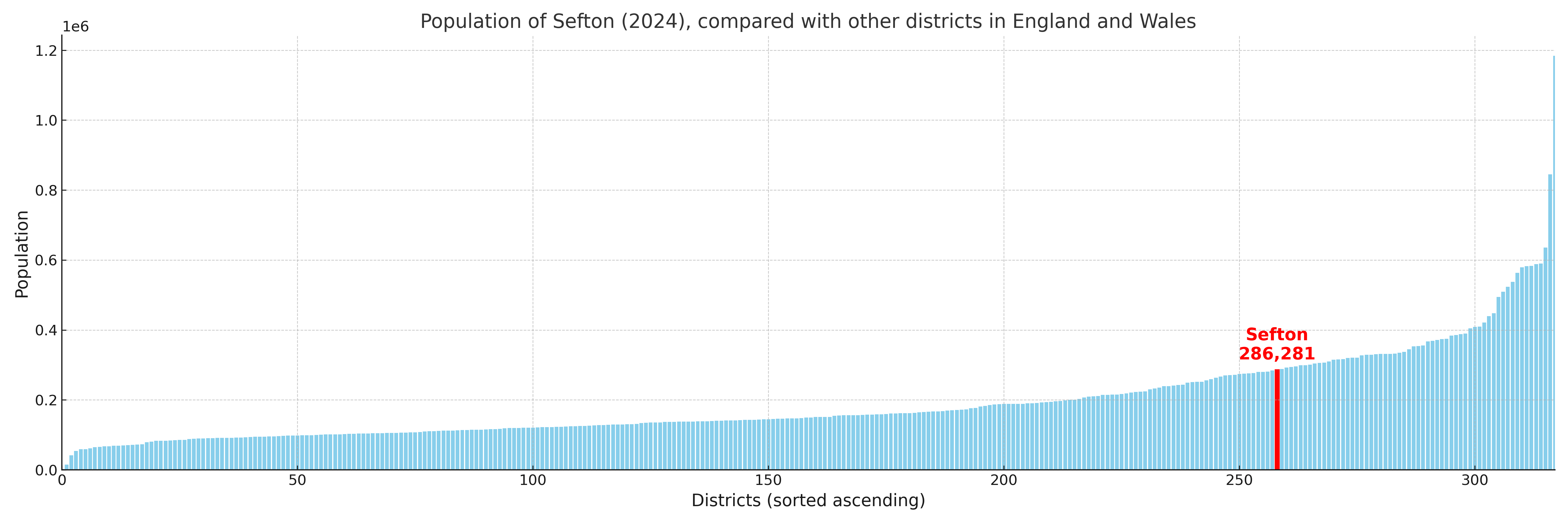
Sefton compared with other districts in the UK
This section shows how Sefton compares with other local authority districts in the UK, using a variety of measures and rankings.
Sefton has 22 electoral wards.

Sefton has a population of 286,281 (2024 mid-year estimate by ONS)
Population and Migration Trends in Sefton
This chart shows the population trend for Sefton from 2015 to 2024. It provides a quick overview of whether the local authority is growing, stable, or declining over time, and helps set context for the migration patterns shown below.
Population change is influenced by natural change (births minus deaths) and migration. The net migration chart below focuses on migration, separating internal migration (moves within the UK) from international migration (moves to and from abroad). Positive values indicate net inflows, while negative values indicate net outflows. The rate labels (per 1,000 residents) help compare migration intensity across years, even when the population size changes.
More local statistics and data for Sefton can be found on the ONS statistics for Sefton.
Latest news about Sefton
Use the search box, or suggested search phrases, below to find recent news, council updates, planning stories, housing developments, transport changes, public services news, local elections, community issues and other local developments related to Sefton. Results may include coverage from UK national, regional and local news websites, as well as official public-sector and local democracy sources.
- Sefton council
- Sefton planning
- Sefton local elections
- Sefton housing
- Sefton transport
- Sefton regeneration
- Sefton public services