Tameside
§ This page gives an overview of the Tameside local authority district, bringing together key facts, maps, and data to help you quickly understand the area. This is one of 361 LAD profiles on Baseview.
Overview ⁞ Tameside lies east of Manchester, bordered by the Pennines and crossed by the River Tame. Towns like Ashton-under-Lyne, with its historic market, and Stalybridge, with canals and mills, reflect the area’s heritage. The Pennine foothills rise steeply, offering open moorland, reservoirs, and scenic walking routes. Parks and green spaces such as Stamford Park add to the landscape, while villages on the uplands retain a rural feel. The district is marked by a strong contrast between industrial valleys and rugged hills.
Tameside Boundary Map
This map shows the official boundary of the Tameside local authority district, based on the latest geographic data published by the Office for National Statistics (ONS). It provides a clear view of the district’s extent and helps you understand how the area fits within the wider regional and national landscape.
Contains OS data © Crown copyright and database right 2025. Source: Office for National Statistics licensed under the Open Government Licence v3.0.
The administrative boundary of Tameside can also be viewed on OpenStreetMap: District Boundary of Tameside.
Key Facts about Tameside
What region is Tameside in? Tameside is in the North West of England, a region within the UK.
What county is Tameside in? Tameside is located in the county of Greater Manchester.
Is Tameside a city? No, Tameside is not a city. (Note: the UK has 76 officially designated cities.)
Who governs Tameside? The local government for this district is: Tameside Borough Council (Metropolitan District).
▶ Official website of Tameside Borough Council 🔗 tameside.gov.uk

Which police force covers Tameside? Policing in Tameside is provided by Greater Manchester Police 🔗 gmp.police.uk, which serves 10 local authority districts: Bolton ⁞ Bury ⁞ Manchester ⁞ Oldham ⁞ Rochdale ⁞ Salford ⁞ Stockport ⁞ Tameside ⁞ Trafford ⁞ Wigan.
Constituencies in Tameside
Tameside is divided into 3 parliamentary constituencies, listed below in alphabetical order.
A constituency is a specific geographical area that elects one Member of Parliament (MP) to represent them in the House of Commons. The United Kingdom is divided into 650 parliamentary constituencies. We have this list page for easy browsing of all UK parliamentary constituencies: List of Constituencies.
Wards in Tameside
Tameside is divided into 19 wards, listed below in alphabetical order.
- Ashton Hurst
- Ashton St Michael's
- Ashton Waterloo
- Audenshaw
- Denton North East
- Denton South
- Denton West
- Droylsden East
- Droylsden West
- Dukinfield
- Dukinfield Stalybridge
- Hyde Godley
- Hyde Newton
- Hyde Werneth
- Longdendale
- Mossley
- St Peter's
- Stalybridge North
- Stalybridge South
In the UK, a ward is a subdivision of a local authority area, used mainly for electoral and statistical purposes. Defined by the ONS, wards represent the primary unit for local elections, each returning one or more councillors to the local council. Wards are also used as a key geography for presenting population and census data. We have this list page for easy browsing of all electoral wards: List of all Electoral Wards in the UK.
Parishes in Tameside
Tameside is part-parished: 1 civil parishes (listed A-Z below) alongside 5 unparished areas.
- Mossley
A civil parish is the lowest tier of local government in England, used for villages, small towns, and suburbs. They have their own local authority, either a parish council or a parish meeting, which provides local services like managing parks, allotments, and streetlights, and represents the community's views to larger councils.
We have this list page for easy browsing of all parishes: List of Civil Parishes in England and Wales.
Post Towns in Tameside
Below is a list of post towns in Tameside, grouped by postcode area:
- OL ▸ Ashton-under-Lyne (OL5 / OL6 / OL7)
- SK ▸ Dukinfield (SK16) ⁞ Hyde (SK14) ⁞ Stalybridge (SK15)
The UK postal hierarchy begins with broad postcode areas (such as “CB” or “M”), which are divided into smaller postcode districts (such as “CB8” or “M1”) to support accurate mail routing. Each postal address is anchored by a designated post town, the official locality name used in the UK postcode system, which operates independently from Local Authority Districts —the administrative boundaries used for council tax and local government services. Because they serve different purposes, a property’s postal address and its local authority district do not always align exactly.
Built-up Areas in Tameside
Tameside covers 15 built-up areas, listed below in alphabetical order.
- Ashton-under-Lyne *
- Audenshaw *
- Bredbury and Woodley *
- Broadbottom *
- Denton (Tameside) *
- Droylsden *
- Dukinfield
- Hadfield *
- Hattersley
- Hyde (Tameside) *
- Lees *
- Manchester *
- Mossley *
- Reddish *
- Stalybridge
In the UK, a Built-up Area (BUA) is a continuous urban area of at least 20 hectares (0.2 km²), defined by the ONS as land where buildings are generally no more than 200 metres apart, such as towns, cities, or large villages. (Note: A BUA name marked with an asterisk (*) indicates that the area is situated partly in the district of Tameside.)
We have this list page for easy browsing of all built-up areas: List of all Built-up Areas in GB.
Railway Stations in Tameside
Tameside is served by a number of National Rail stations, providing rail connections to nearby towns, cities, and destinations across Great Britain. The railway stations listed below are located within the Tameside Local Authority District and are grouped by train operating company for clarity.
- Northern Trains ▸ Guide Bridge (M34 5HF) ⁞ Hadfield (SK14 7AA) ⁞ Mossley (Manchester) (OL5 0AB) ⁞ Flowery Field (SK14 4BZ) ⁞ Ashton-Under-Lyne (OL6 6JP) ⁞ Newton For Hyde (SK14 2PJ) ⁞ Broadbottom (SK14 6AX) ⁞ Hattersley (SK14 3HG) ⁞ Godley (SK14 4DP) ⁞ Hyde Central (SK14 1AA) ⁞ Hyde North (SK16 5RH) ⁞ Fairfield (M43 6TT) ⁞ Denton (M34 3NS)
- TransPennine Express ▸ Stalybridge (SK15 1RF)
This is a district-level view only. For a complete list of all National Rail stations across Great Britain, see the UK National Rail Stations Directory.
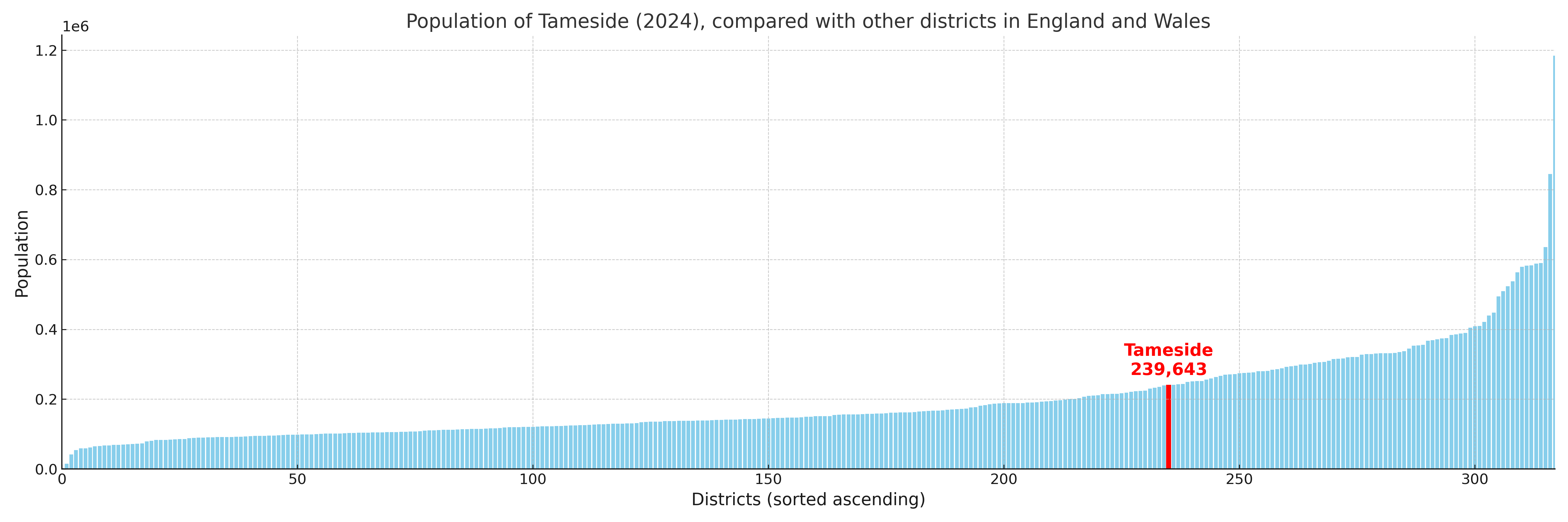
Tameside compared with other districts in the UK
This section shows how Tameside compares with other local authority districts in the UK, using a variety of measures and rankings.
Tameside has 19 electoral wards.

Tameside has a population of 239,643 (2024 mid-year estimate by ONS)
Population and Migration Trends in Tameside
This chart shows the population trend for Tameside from 2015 to 2024. It provides a quick overview of whether the local authority is growing, stable, or declining over time, and helps set context for the migration patterns shown below.
Population change is influenced by natural change (births minus deaths) and migration. The net migration chart below focuses on migration, separating internal migration (moves within the UK) from international migration (moves to and from abroad). Positive values indicate net inflows, while negative values indicate net outflows. The rate labels (per 1,000 residents) help compare migration intensity across years, even when the population size changes.
More local statistics and data for Tameside can be found on the ONS statistics for Tameside.
Latest news about Tameside
Use the search box, or suggested search phrases, below to find recent news, council updates, planning stories, housing developments, transport changes, public services news, local elections, community issues and other local developments related to Tameside. Results may include coverage from UK national, regional and local news websites, as well as official public-sector and local democracy sources.
- Tameside council
- Tameside planning
- Tameside local elections
- Tameside housing
- Tameside transport
- Tameside regeneration
- Tameside public services