Pendle
§ This page gives an overview of the Pendle local authority district, bringing together key facts, maps, and data to help you quickly understand the area. This is one of 361 LAD profiles on Baseview.
Overview ⁞ Pendle lies in eastern Lancashire, named after the distinctive Pendle Hill, a landmark rising above moorland and valleys. Nelson and Colne are the main towns, with textile heritage, markets, and local museums. The Leeds and Liverpool Canal runs through, while villages like Barrowford and Trawden sit among rolling countryside. Pendle is also associated with the famous Pendle Witches of the 17th century, adding historic intrigue to its scenic uplands and rural charm.
Pendle Boundary Map
This map shows the official boundary of the Pendle local authority district, based on the latest geographic data published by the Office for National Statistics (ONS). It provides a clear view of the district’s extent and helps you understand how the area fits within the wider regional and national landscape.
Contains OS data © Crown copyright and database right 2025. Source: Office for National Statistics licensed under the Open Government Licence v3.0.
The administrative boundary of Pendle can also be viewed on OpenStreetMap: District Boundary of Pendle.
Key Facts about Pendle
What region is Pendle in? Pendle is in the North West of England, a region within the UK.
What county is Pendle in? Pendle is located in the county of Lancashire.
Is Pendle a city? No, Pendle is not a city. (Note: the UK has 76 officially designated cities.)
Who governs Pendle? The local authority for this district is: Pendle Borough Council - responsible for district-level services. Since Lancashire is a two-tier area, county-level services are handled by: Lancashire County Council.
▶ Official website of Pendle Borough Council 🔗 pendle.gov.uk

Which police force covers Pendle? Policing in Pendle is provided by Lancashire Constabulary 🔗 lancashire.police.uk, which serves 14 local authority districts: Blackburn with Darwen ⁞ Blackpool ⁞ Burnley ⁞ Chorley ⁞ Fylde ⁞ Hyndburn ⁞ Lancaster ⁞ Pendle ⁞ Preston ⁞ Ribble Valley ⁞ Rossendale ⁞ South Ribble ⁞ West Lancashire ⁞ Wyre.
Constituencies in Pendle
Pendle is divided into 2 parliamentary constituencies, listed below in alphabetical order.
A constituency is a specific geographical area that elects one Member of Parliament (MP) to represent them in the House of Commons. The United Kingdom is divided into 650 parliamentary constituencies. We have this list page for easy browsing of all UK parliamentary constituencies: List of Constituencies.
Wards in Pendle
Pendle is divided into 12 wards, listed below in alphabetical order.
- Barnoldswick
- Barrowford & Pendleside
- Boulsworth & Foulridge
- Bradley
- Brierfield East & Clover Hill
- Brierfield West & Reedley
- Earby & Coates
- Fence & Higham
- Marsden & Southfield
- Vivary Bridge
- Waterside & Horsfield
- Whitefield & Walverden
In the UK, a ward is a subdivision of a local authority area, used mainly for electoral and statistical purposes. Defined by the ONS, wards represent the primary unit for local elections, each returning one or more councillors to the local council. Wards are also used as a key geography for presenting population and census data. We have this list page for easy browsing of all electoral wards: List of all Electoral Wards in the UK.
Parishes in Pendle
Pendle is fully parished: 18 civil parishes, listed A-Z below.
- Barley-with-Wheatley Booth
- Barnoldswick
- Barrowford
- Blacko
- Brierfield
- Colne
- Earby
- Foulridge
- Goldshaw Booth
- Higham-with-West Close Booth
- Kelbrook and Sough
- Laneshaw Bridge
- Nelson
- Old Laund Booth
- Reedley Hallows
- Roughlee Booth
- Salterforth
- Trawden Forest
A civil parish is the lowest tier of local government in England, used for villages, small towns, and suburbs. They have their own local authority, either a parish council or a parish meeting, which provides local services like managing parks, allotments, and streetlights, and represents the community's views to larger councils.
We have this list page for easy browsing of all parishes: List of Civil Parishes in England and Wales.
Post Towns in Pendle
Below is a list of post towns in Pendle, grouped by postcode area:
- BB ▸ Barnoldswick (BB18 / BB94) ⁞ Colne (BB8) ⁞ Nelson (BB9)
The UK postal hierarchy begins with broad postcode areas (such as “CB” or “M”), which are divided into smaller postcode districts (such as “CB8” or “M1”) to support accurate mail routing. Each postal address is anchored by a designated post town, the official locality name used in the UK postcode system, which operates independently from Local Authority Districts —the administrative boundaries used for council tax and local government services. Because they serve different purposes, a property’s postal address and its local authority district do not always align exactly.
Built-up Areas in Pendle
Pendle covers 13 built-up areas, listed below in alphabetical order.
- Barnoldswick
- Barrowford
- Brierfield *
- Burnley *
- Colne
- Earby
- Fence
- Foulridge
- Higham (Pendle) *
- Nelson (Pendle)
- Padiham *
- Sough
- Trawden
In the UK, a Built-up Area (BUA) is a continuous urban area of at least 20 hectares (0.2 km²), defined by the ONS as land where buildings are generally no more than 200 metres apart, such as towns, cities, or large villages. (Note: A BUA name marked with an asterisk (*) indicates that the area is situated partly in the district of Pendle.)
We have this list page for easy browsing of all built-up areas: List of all Built-up Areas in GB.
Railway Stations in Pendle
Pendle is served by a number of National Rail stations, providing rail connections to nearby towns, cities, and destinations across Great Britain. The railway stations listed below are located within the Pendle Local Authority District and are grouped by train operating company for clarity.
- Northern Trains ▸ Nelson (BB9 9SF) ⁞ Colne (BB8 9NX) ⁞ Brierfield (BB9 5PU)
This is a district-level view only. For a complete list of all National Rail stations across Great Britain, see the UK National Rail Stations Directory.
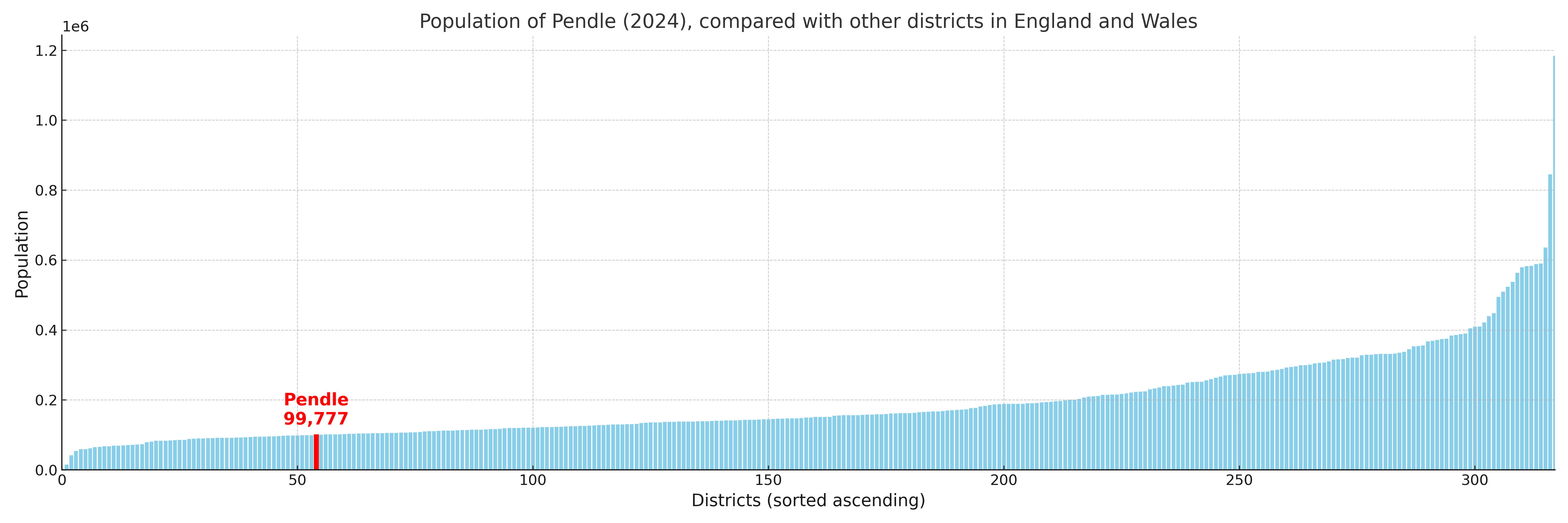
Pendle compared with other districts in the UK
This section shows how Pendle compares with other local authority districts in the UK, using a variety of measures and rankings.
Pendle has 12 electoral wards.

Pendle has a population of 99,777 (2024 mid-year estimate by ONS)
Population and Migration Trends in Pendle
This chart shows the population trend for Pendle from 2015 to 2024. It provides a quick overview of whether the local authority is growing, stable, or declining over time, and helps set context for the migration patterns shown below.
Population change is influenced by natural change (births minus deaths) and migration. The net migration chart below focuses on migration, separating internal migration (moves within the UK) from international migration (moves to and from abroad). Positive values indicate net inflows, while negative values indicate net outflows. The rate labels (per 1,000 residents) help compare migration intensity across years, even when the population size changes.
More local statistics and data for Pendle can be found on the ONS statistics for Pendle.
Latest news about Pendle
Use the search box, or suggested search phrases, below to find recent news, council updates, planning stories, housing developments, transport changes, public services news, local elections, community issues and other local developments related to Pendle. Results may include coverage from UK national, regional and local news websites, as well as official public-sector and local democracy sources.
- Pendle council
- Pendle planning
- Pendle local elections
- Pendle housing
- Pendle transport
- Pendle regeneration
- Pendle public services