West Lancashire
§ This page gives an overview of the West Lancashire local authority district, bringing together key facts, maps, and data to help you quickly understand the area. This is one of 361 LAD profiles on Baseview.
Overview ⁞ West Lancashire is a rural district stretching from the Lancashire Plain to the edge of Merseyside, with Ormskirk as its historic market town and Skelmersdale as a major centre. The flat, fertile land of the West Lancashire Plain is criss-crossed by drainage ditches and agricultural fields, particularly suited for crop farming. The River Douglas and Leeds and Liverpool Canal flow through the area, adding waterside character. Villages like Burscough and Parbold provide charm and access to nearby countryside, while the district’s open farmland contrasts with hilly landscapes at its eastern edge.
West Lancashire Boundary Map
This map shows the official boundary of the West Lancashire local authority district, based on the latest geographic data published by the Office for National Statistics (ONS). It provides a clear view of the district’s extent and helps you understand how the area fits within the wider regional and national landscape.
Contains OS data © Crown copyright and database right 2025. Source: Office for National Statistics licensed under the Open Government Licence v3.0.
The administrative boundary of West Lancashire can also be viewed on OpenStreetMap: District Boundary of West Lancashire.
Key Facts about West Lancashire
What region is West Lancashire in? West Lancashire is in the North West of England, a region within the UK.
What county is West Lancashire in? West Lancashire is located in the county of Lancashire.
Is West Lancashire a city? No, West Lancashire is not a city. (Note: the UK has 76 officially designated cities.)
Who governs West Lancashire? The local authority for this district is: West Lancashire District Council - responsible for district-level services. Since Lancashire is a two-tier area, county-level services are handled by: Lancashire County Council.
▶ Official website of West Lancashire District Council 🔗 westlancs.gov.uk
Which police force covers West Lancashire? Policing in West Lancashire is provided by Lancashire Constabulary 🔗 lancashire.police.uk, which serves 14 local authority districts: Blackburn with Darwen ⁞ Blackpool ⁞ Burnley ⁞ Chorley ⁞ Fylde ⁞ Hyndburn ⁞ Lancaster ⁞ Pendle ⁞ Preston ⁞ Ribble Valley ⁞ Rossendale ⁞ South Ribble ⁞ West Lancashire ⁞ Wyre.
West Lancashire in International Geographies
In the International Territorial Levels (ITLs) hierarchy, West Lancashire is within an ITLs Level 3 area:
- (ITL 1) North West
- (ITL 2) ⇒ Lancashire
- (ITL 3) ⇒⇒ Chorley and West Lancashire
The International Territorial Levels are used by OECD member countries for statistical purposes to classify administrative areas. We have this listable page for easy browsing of ITL names and codes: International Territorial Levels.
Constituencies in West Lancashire
West Lancashire is divided into 2 parliamentary constituencies, listed below in alphabetical order.
A constituency is a specific geographical area that elects one Member of Parliament (MP) to represent them in the House of Commons. The United Kingdom is divided into 650 parliamentary constituencies. We have this list page for easy browsing of all UK parliamentary constituencies: List of Constituencies.
Wards in West Lancashire
West Lancashire is divided into 15 wards, listed below in alphabetical order.
- Aughton & Holborn
- Burscough Bridge & Rufford
- Burscough Town
- North Meols & Hesketh Bank
- Old Skelmersdale
- Ormskirk East
- Ormskirk West
- Rural North East
- Rural South
- Rural West
- Skelmersdale North
- Skelmersdale South
- Tanhouse & Skelmersdale Town Centre
- Tarleton Village
- Up Holland
In the UK, a ward is a subdivision of a local authority area, used mainly for electoral and statistical purposes. Defined by the ONS, wards represent the primary unit for local elections, each returning one or more councillors to the local council. Wards are also used as a key geography for presenting population and census data. We have this list page for easy browsing of all electoral wards: List of all Electoral Wards in the UK.
Parishes in West Lancashire
West Lancashire is part-parished: 21 civil parishes (listed A-Z below) alongside 1 unparished areas.
- Aughton
- Bickerstaffe
- Bispham
- Burscough
- Dalton
- Downholland
- Great Altcar
- Halsall
- Hesketh-with-Becconsall
- Hilldale
- Lathom
- Lathom South
- Newburgh
- North Meols
- Parbold
- Rufford
- Scarisbrick
- Simonswood
- Tarleton
- Up Holland
- Wrightington
A civil parish is the lowest tier of local government in England, used for villages, small towns, and suburbs. They have their own local authority, either a parish council or a parish meeting, which provides local services like managing parks, allotments, and streetlights, and represents the community's views to larger councils.
We have this list page for easy browsing of all parishes: List of Civil Parishes in England and Wales.
Post Towns in West Lancashire
Below is a list of post towns in West Lancashire, grouped by postcode area:
- L ▸ Ormskirk (L39 / L40)
- WN ▸ Skelmersdale (WN8)
The UK postal hierarchy begins with broad postcode areas (such as “CB” or “M”), which are divided into smaller postcode districts (such as “CB8” or “M1”) to support accurate mail routing. Each postal address is anchored by a designated post town, the official locality name used in the UK postcode system, which operates independently from Local Authority Districts —the administrative boundaries used for council tax and local government services. Because they serve different purposes, a property’s postal address and its local authority district do not always align exactly.
Built-up Areas in West Lancashire
West Lancashire covers 28 built-up areas, listed below in alphabetical order.
- Appley Bridge *
- Aughton
- Banks
- Bescar
- Burscough
- Drummersdale
- Formby *
- Haskayne
- Hill Dale
- Holmeswood
- Hundred End
- Hunger Hill (West Lancashire) *
- Kirkby *
- Maghull *
- Mawdesley *
- Mere Brow
- Mossy Lea
- Newburgh (West Lancashire)
- Ormskirk
- Orrell *
- Parbold
- Ring o' Bells
- Rufford (West Lancashire)
- Scarisbrick
- Shevington Moor *
- Skelmersdale
- Southport *
- Tarleton and Hesketh Bank *
In the UK, a Built-up Area (BUA) is a continuous urban area of at least 20 hectares (0.2 km²), defined by the ONS as land where buildings are generally no more than 200 metres apart, such as towns, cities, or large villages. (Note: A BUA name marked with an asterisk (*) indicates that the area is situated partly in the district of West Lancashire.)
We have this list page for easy browsing of all built-up areas: List of all Built-up Areas in GB.
Railway Stations in West Lancashire
West Lancashire is served by a number of National Rail stations, providing rail connections to nearby towns, cities, and destinations across Great Britain. The railway stations listed below are located within the West Lancashire Local Authority District and are grouped by train operating company for clarity.
- Merseyrail ▸ Ormskirk (L39 2YN) ⁞ Town Green (L39 6RG) ⁞ Aughton Park (L39 5BT)
- Northern Trains ▸ Burscough Bridge (L40 0RZ) ⁞ Appley Bridge (WN6 9AE) ⁞ Parbold (WN8 7NU) ⁞ Burscough Junction (L40 5SP) ⁞ Upholland (WN8 9QD) ⁞ Rufford (L40 1TB) ⁞ Bescar Lane (L40 9QP) ⁞ New Lane (L40 0RY) ⁞ Hoscar (L40 4BL)
This is a district-level view only. For a complete list of all National Rail stations across Great Britain, see the UK National Rail Stations Directory.
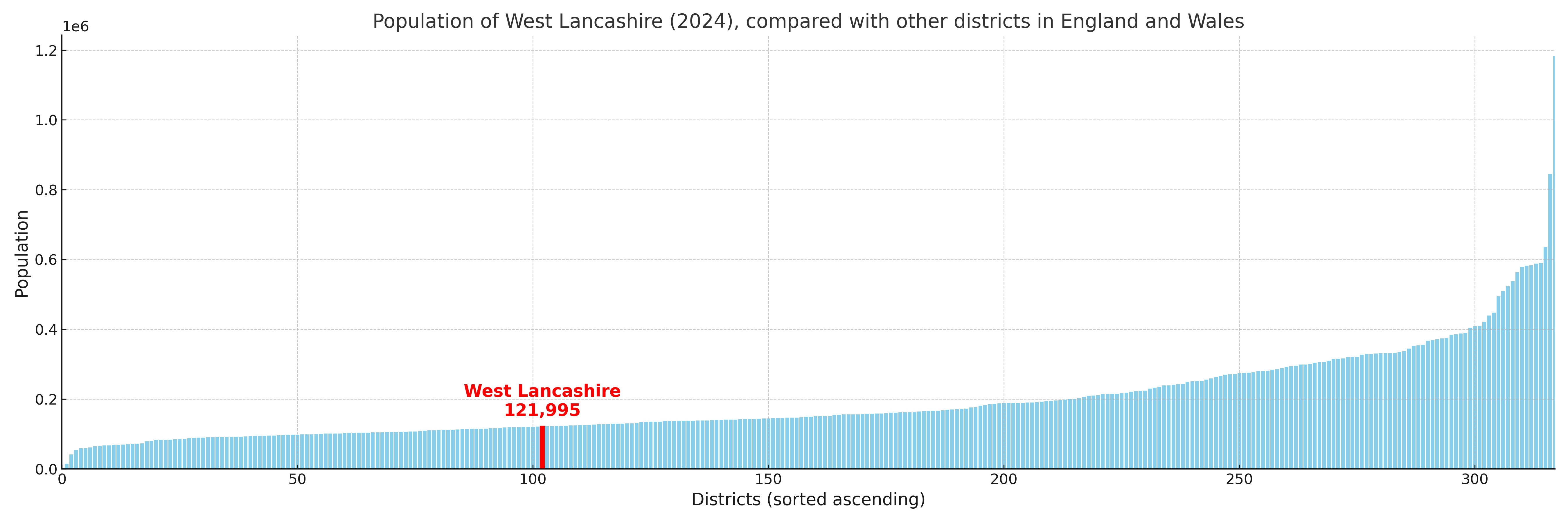
West Lancashire compared with other districts in the UK
This section shows how West Lancashire compares with other local authority districts in the UK, using a variety of measures and rankings.
West Lancashire has 15 electoral wards.

West Lancashire has a population of 121,995 (2024 mid-year estimate by ONS)
Population and Migration Trends in West Lancashire
This chart shows the population trend for West Lancashire from 2015 to 2024. It provides a quick overview of whether the local authority is growing, stable, or declining over time, and helps set context for the migration patterns shown below.
Population change is influenced by natural change (births minus deaths) and migration. The net migration chart below focuses on migration, separating internal migration (moves within the UK) from international migration (moves to and from abroad). Positive values indicate net inflows, while negative values indicate net outflows. The rate labels (per 1,000 residents) help compare migration intensity across years, even when the population size changes.
More local statistics and data for West Lancashire can be found on the ONS statistics for West Lancashire.
Latest news about West Lancashire
Use the search box, or suggested search phrases, below to find recent news, council updates, planning stories, housing developments, transport changes, public services news, local elections, community issues and other local developments related to West Lancashire. Results may include coverage from UK national, regional and local news websites, as well as official public-sector and local democracy sources.
- West Lancashire council
- West Lancashire planning
- West Lancashire local elections
- West Lancashire housing
- West Lancashire transport
- West Lancashire regeneration
- West Lancashire public services