Liverpool
§ This page gives an overview of the Liverpool local authority district, bringing together key facts, maps, and data to help you quickly understand the area. This is one of 361 LAD profiles on Baseview.
Overview ⁞ Liverpool, on the River Mersey, is an iconic city with a rich maritime and cultural heritage. The historic waterfront features the “Three Graces” – the Royal Liver Building, Cunard Building, and Port of Liverpool Building – along with the Albert Dock, home to museums and galleries including Tate Liverpool and the Maritime Museum. The city centre is renowned for its music legacy, particularly The Beatles, with attractions such as The Cavern Club and Beatles Story. Liverpool Cathedral and the Metropolitan Cathedral dominate the skyline, while Sefton Park and Stanley Park provide green spaces. The River Mersey, docks, and cultural landmarks define its unique character.
Liverpool Boundary Map
This map shows the official boundary of the Liverpool local authority district, based on the latest geographic data published by the Office for National Statistics (ONS). It provides a clear view of the district’s extent and helps you understand how the area fits within the wider regional and national landscape.
Contains OS data © Crown copyright and database right 2025. Source: Office for National Statistics licensed under the Open Government Licence v3.0.
The administrative boundary of Liverpool can also be viewed on OpenStreetMap: District Boundary of Liverpool.
Key Facts about Liverpool
What region is Liverpool in? Liverpool is in the North West of England, a region within the UK.
What county is Liverpool in? Liverpool is located in the county of Merseyside.
Is Liverpool a city? Yes, Liverpool is a city. Liverpool holds official city status as one of the 76 designated cities in the UK.
Who governs Liverpool? The local government for this district is: Liverpool City Council (Metropolitan District).
▶ Official website of Liverpool City Council 🔗 liverpool.gov.uk
Which police force covers Liverpool? Policing in Liverpool is provided by Merseyside Police 🔗 merseyside.police.uk, which serves 5 local authority districts: Knowsley ⁞ Liverpool ⁞ Sefton ⁞ St. Helens ⁞ Wirral.
Liverpool in International Geographies
In the International Territorial Levels (ITLs) hierarchy, Liverpool is an ITLs Level 3 area:
- (ITL 1) North West
- (ITL 2) ⇒ Merseyside
- (ITL 3) ⇒⇒ Liverpool
The International Territorial Levels are used by OECD member countries for statistical purposes to classify administrative areas. We have this listable page for easy browsing of ITL names and codes: International Territorial Levels.
Constituencies in Liverpool
Liverpool is divided into 5 parliamentary constituencies, listed below in alphabetical order.
A constituency is a specific geographical area that elects one Member of Parliament (MP) to represent them in the House of Commons. The United Kingdom is divided into 650 parliamentary constituencies. We have this list page for easy browsing of all UK parliamentary constituencies: List of Constituencies.
Wards in Liverpool
Liverpool is divided into 64 wards, listed below in alphabetical order.
- Aigburth
- Allerton
- Anfield
- Arundel
- Belle Vale
- Broadgreen
- Brownlow Hill
- Calderstones
- Canning
- Childwall
- Church
- City Centre North
- City Centre South
- Clubmoor East
- Clubmoor West
- County
- Croxteth
- Croxteth Country Park
- Dingle
- Edge Hill
- Everton East
- Everton North
- Everton West
- Fazakerley East
- Fazakerley North
- Fazakerley West
- Festival Gardens
- Garston
- Gateacre
- Grassendale & Cressington
- Greenbank Park
- Kensington & Fairfield
- Kirkdale East
- Kirkdale West
- Knotty Ash & Dovecot Park
- Mossley Hill
- Much Woolton & Hunts Cross
- Norris Green
- Old Swan East
- Old Swan West
- Orrell Park
- Penny Lane
- Princes Park
- Sandfield Park
- Sefton Park
- Smithdown
- Speke
- Springwood
- St Michaels
- Stoneycroft
- Toxteth
- Tuebrook Breckside Park
- Tuebrook Larkhill
- Vauxhall
- Walton
- Waterfront North
- Waterfront South
- Wavertree Garden Suburb
- Wavertree Village
- West Derby Deysbrook
- West Derby Leyfield
- West Derby Muirhead
- Woolton Village
- Yew Tree
In the UK, a ward is a subdivision of a local authority area, used mainly for electoral and statistical purposes. Defined by the ONS, wards represent the primary unit for local elections, each returning one or more councillors to the local council. Wards are also used as a key geography for presenting population and census data. We have this list page for easy browsing of all electoral wards: List of all Electoral Wards in the UK.
Parishes in Liverpool
Liverpool is entirely unparished—there are no civil parishes in this local authority district.
Parishes are the lowest tier of local government; where they don’t exist, those very local services and representation sit directly with the principal council. We have this list page for easy browsing of all parishes: List of Civil Parishes in England and Wales.
Post Towns in Liverpool
Below is a list of post towns in Liverpool, grouped by postcode area:
L ▸ Liverpool (L1 / L2 / L3 / L4 / L5 / L6 / L7 / L8 / L9 / L10 / L11 / L12 / L13 / L14 / L15 / L16 / L17 / L18 / L19 / L20 / L21 / L22 / L23 / L24 / L25 / L26 / L27 / L28 / L29 / L31 / L32 / L33 / L36 / L37 / L38 / L67 / L68 / L69 / L70 / L71 / L72 / L73 / L74 / L75)
The UK postal hierarchy begins with broad postcode areas (such as “CB” or “M”), which are divided into smaller postcode districts (such as “CB8” or “M1”) to support accurate mail routing. Each postal address is anchored by a designated post town, the official locality name used in the UK postcode system, which operates independently from Local Authority Districts —the administrative boundaries used for council tax and local government services. Because they serve different purposes, a property’s postal address and its local authority district do not always align exactly.
Built-up Areas in Liverpool
Liverpool covers 4 built-up areas, listed below in alphabetical order.
- Bootle (Sefton) *
- Huyton with Roby *
- Kirkby *
- Liverpool *
In the UK, a Built-up Area (BUA) is a continuous urban area of at least 20 hectares (0.2 km²), defined by the ONS as land where buildings are generally no more than 200 metres apart, such as towns, cities, or large villages. (Note: A BUA name marked with an asterisk (*) indicates that the area is situated partly in the district of Liverpool.)
We have this list page for easy browsing of all built-up areas: List of all Built-up Areas in GB.
Railway Stations in Liverpool
Liverpool is served by a number of National Rail stations, providing rail connections to nearby towns, cities, and destinations across Great Britain. The railway stations listed below are located within the Liverpool Local Authority District and are grouped by train operating company for clarity.
- Merseyrail ▸ Liverpool Central (L1 1JT) ⁞ Moorfields (L2 2BS) ⁞ Liverpool James Street (L2 7PQ) ⁞ Liverpool South Parkway (L19 5NE) ⁞ Hunts Cross (L25 0NN) ⁞ Fazakerley (L9 9EW) ⁞ Sandhills (L5 3TX) ⁞ St Michaels (L17 3TX) ⁞ Orrell Park (L9 8BU) ⁞ Kirkdale (L20 2BN) ⁞ Brunswick (L8 6XP) ⁞ Aigburth (L17 6AG) ⁞ Cressington (L19 0PE) ⁞ Rice Lane (L9 3BY) ⁞ Walton (Merseyside) (L9 1EY) ⁞ Bank Hall (L20 8BX)
- Network Rail ▸ Liverpool Lime Street (L1 1JD)
- Northern Trains ▸ Broad Green (L14 3NG) ⁞ Wavertree Technology Park (L13 1EG) ⁞ Edge Hill (L7 1AD) ⁞ Mossley Hill (L18 8AG) ⁞ West Allerton (L18 7HF)
This is a district-level view only. For a complete list of all National Rail stations across Great Britain, see the UK National Rail Stations Directory.
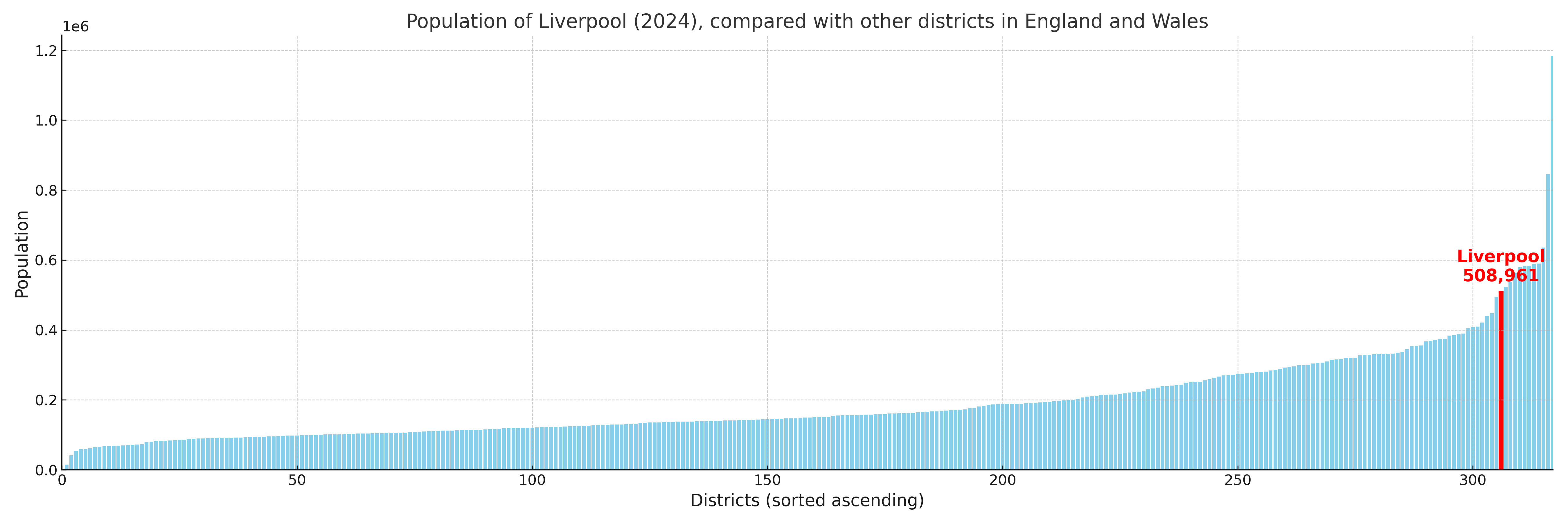
Liverpool compared with other districts in the UK
This section shows how Liverpool compares with other local authority districts in the UK, using a variety of measures and rankings.
Liverpool has 64 electoral wards.

Liverpool has a population of 508,961 (2024 mid-year estimate by ONS)
Population and Migration Trends in Liverpool
This chart shows the population trend for Liverpool from 2015 to 2024. It provides a quick overview of whether the local authority is growing, stable, or declining over time, and helps set context for the migration patterns shown below.
Population change is influenced by natural change (births minus deaths) and migration. The net migration chart below focuses on migration, separating internal migration (moves within the UK) from international migration (moves to and from abroad). Positive values indicate net inflows, while negative values indicate net outflows. The rate labels (per 1,000 residents) help compare migration intensity across years, even when the population size changes.
More local statistics and data for Liverpool can be found on the ONS statistics for Liverpool.
Latest news about Liverpool
Use the search box, or suggested search phrases, below to find recent news, council updates, planning stories, housing developments, transport changes, public services news, local elections, community issues and other local developments related to Liverpool. Results may include coverage from UK national, regional and local news websites, as well as official public-sector and local democracy sources.
- Liverpool council
- Liverpool planning
- Liverpool local elections
- Liverpool housing
- Liverpool transport
- Liverpool regeneration
- Liverpool public services