Cheshire East
§ This page gives an overview of the Cheshire East local authority district, bringing together key facts, maps, and data to help you quickly understand the area. This is one of 361 LAD profiles on Baseview.
Overview ⁞ Cheshire East is a large district combining historic market towns, rural countryside, and parts of the Peak District National Park. Macclesfield, once a silk town, lies on the edge of the Pennines, while Crewe is renowned for its railway heritage. Congleton and Sandbach add charm with historic markets, while the countryside is dotted with villages, canals, and stately homes such as Tatton Park and Lyme Park. The landscape ranges from rolling Cheshire farmland to the rugged uplands of the Peak District, offering scenic variety.
Cheshire East Boundary Map
This map shows the official boundary of the Cheshire East local authority district, based on the latest geographic data published by the Office for National Statistics (ONS). It provides a clear view of the district’s extent and helps you understand how the area fits within the wider regional and national landscape.
Contains OS data © Crown copyright and database right 2025. Source: Office for National Statistics licensed under the Open Government Licence v3.0.
The administrative boundary of Cheshire East can also be viewed on OpenStreetMap: District Boundary of Cheshire East.
Key Facts about Cheshire East
What region is Cheshire East in? Cheshire East is in the North West of England, a region within the UK.
What county is Cheshire East in? Cheshire East is in the county of Cheshire.
Is Cheshire East a city? No, Cheshire East is not a city. (Note: the UK has 76 officially designated cities.)
Who governs Cheshire East? The local government for this district is: Cheshire East Council (Unitary Authority).
▶ Official website of Cheshire East Council 🔗 cheshireeast.gov.uk
Which police force covers Cheshire East? Policing in Cheshire East is provided by Cheshire Constabulary 🔗 cheshire.police.uk, which serves 4 local authority districts: Cheshire East ⁞ Cheshire West and Chester ⁞ Halton ⁞ Warrington.
Cheshire East in International Geographies
In the International Territorial Levels (ITLs) hierarchy, Cheshire East is an ITLs Level 3 area:
- (ITL 1) North West
- (ITL 2) ⇒ Cheshire
- (ITL 3) ⇒⇒ Cheshire East
The International Territorial Levels are used by OECD member countries for statistical purposes to classify administrative areas. We have this listable page for easy browsing of ITL names and codes: International Territorial Levels.
Constituencies in Cheshire East
Cheshire East is divided into 6 parliamentary constituencies, listed below in alphabetical order.
A constituency is a specific geographical area that elects one Member of Parliament (MP) to represent them in the House of Commons. The United Kingdom is divided into 650 parliamentary constituencies. We have this list page for easy browsing of all UK parliamentary constituencies: List of Constituencies.
Wards in Cheshire East
Cheshire East is divided into 52 wards, listed below in alphabetical order.
- Alderley Edge
- Alsager
- Audlem
- Bollington
- Brereton Rural
- Broken Cross and Upton
- Bunbury
- Chelford
- Congleton East
- Congleton West
- Crewe Central
- Crewe East
- Crewe North
- Crewe South
- Crewe St Barnabas
- Crewe West
- Dane Valley
- Disley
- Gawsworth
- Handforth
- Haslington
- High Legh
- Knutsford
- Leighton
- Macclesfield Central
- Macclesfield East
- Macclesfield Hurdsfield
- Macclesfield South
- Macclesfield Tytherington
- Macclesfield West and Ivy
- Middlewich
- Mobberley
- Nantwich North and West
- Nantwich South and Stapeley
- Odd Rode
- Poynton East and Pott Shrigley
- Poynton West and Adlington
- Prestbury
- Sandbach Elworth
- Sandbach Ettiley Heath and Wheelock
- Sandbach Heath and East
- Sandbach Town
- Shavington
- Sutton
- Willaston and Rope
- Wilmslow Dean Row
- Wilmslow East
- Wilmslow Lacey Green
- Wilmslow West and Chorley
- Wistaston
- Wrenbury
- Wybunbury
In the UK, a ward is a subdivision of a local authority area, used mainly for electoral and statistical purposes. Defined by the ONS, wards represent the primary unit for local elections, each returning one or more councillors to the local council. Wards are also used as a key geography for presenting population and census data. We have this list page for easy browsing of all electoral wards: List of all Electoral Wards in the UK.
Parishes in Cheshire East
Cheshire East is part-parished: 126 civil parishes (listed A-Z below) alongside 1 unparished areas.
- Adlington
- Alderley Edge
- Alpraham and Calveley
- Alsager
- Arclid
- Ashley
- Aston by Budworth
- Aston juxta Mondrum
- Audlem
- Austerson
- Baddiley
- Baddington
- Barthomley
- Betchton
- Bexton
- Bickerton
- Bollington
- Bosley
- Bradwall
- Brereton
- Brindley
- Broomhall
- Buerton
- Bulkeley and Ridley
- Bunbury
- Burland and Acton
- Chelford
- Cholmondeley
- Cholmondeston
- Chorley (Wilmslow West and Chorley Ward)
- Chorley (Wrenbury Ward)
- Church Lawton
- Church Minshull
- Congleton
- Coole Pilate
- Cranage
- Crewe
- Disley
- Dodcott cum Wilkesley
- Doddington and District
- Eaton
- Egerton
- Faddiley
- Gawsworth
- Goostrey
- Great Warford
- Handforth
- Hankelow
- Haslington
- Hassall
- Hatherton
- Haughton
- Henbury
- High Legh
- Higher Hurdsfield
- Holmes Chapel
- Hough and Chorlton
- Hulme Walfield
- Kettleshulme and Lyme Handley
- Knutsford
- Leighton
- Little Bollington with Agden
- Little Warford
- Lower Withington
- Macclesfield
- Macclesfield Forest and Wildboarclough
- Marbury and District
- Marthall
- Marton
- Mere
- Middlewich
- Millington and Rostherne
- Minshull Vernon
- Mobberley
- Moreton cum Alcumlow
- Moston
- Mottram St. Andrew
- Nantwich
- Nether Alderley
- Newbold Astbury
- Newhall
- North Rode
- Odd Rode
- Ollerton
- Over Alderley
- Peckforton
- Peover Inferior
- Peover Superior and Snelson
- Pickmere
- Plumley
- Poole
- Pott Shrigley
- Poynton with Worth
- Prestbury
- Rainow
- Rope
- Sandbach
- Shavington cum Gresty
- Siddington
- Smallwood
- Somerford
- Somerford Booths
- Sound
- Spurstow
- Stapeley and District
- Stoke and Hurleston
- Styal
- Sutton
- Swettenham
- Tabley Inferior
- Tabley Superior
- Toft
- Twemlow
- Walgherton
- Wardle
- Warmingham
- Weston and Crewe Green
- Wettenhall
- Willaston
- Wilmslow
- Wincle
- Wistaston
- Woolstanwood
- Worleston
- Wrenbury cum Frith
- Wybunbury
A civil parish is the lowest tier of local government in England, used for villages, small towns, and suburbs. They have their own local authority, either a parish council or a parish meeting, which provides local services like managing parks, allotments, and streetlights, and represents the community's views to larger councils.
We have this list page for easy browsing of all parishes: List of Civil Parishes in England and Wales.
Post Towns in Cheshire East
Below is a list of post towns in Cheshire East, grouped by postcode area:
- CW ▸ Congleton (CW12) ⁞ Crewe (CW1 / CW2 / CW3 / CW4 / CW98) ⁞ Middlewich (CW10) ⁞ Nantwich (CW5) ⁞ Sandbach (CW11)
- SK ▸ Alderley Edge (SK9) ⁞ Macclesfield (SK10 / SK11) ⁞ Wilmslow (SK9)
- WA ▸ Knutsford (WA16)
The UK postal hierarchy begins with broad postcode areas (such as “CB” or “M”), which are divided into smaller postcode districts (such as “CB8” or “M1”) to support accurate mail routing. Each postal address is anchored by a designated post town, the official locality name used in the UK postcode system, which operates independently from Local Authority Districts —the administrative boundaries used for council tax and local government services. Because they serve different purposes, a property’s postal address and its local authority district do not always align exactly.
Built-up Areas in Cheshire East
Cheshire East covers 76 built-up areas, listed below in alphabetical order.
- Adlington (Cheshire East)
- Alderley Edge
- Alpraham
- Alsager *
- Appleton Thorn *
- Aston (Cheshire East)
- Audlem
- Bollington
- Brown Knowl *
- Bucklow Hill
- Bunbury *
- Butt Green
- Chelford
- Congleton
- Cranage
- Crewe
- Dean Row
- Disley
- Elworth
- Gawsworth
- Goostrey *
- Great Warford
- Hale (Trafford) *
- Hankelow
- Harriseahead, Mow Cop and Newchapel *
- Haslington
- Hazel Grove *
- High Lane *
- High Legh
- Higher Poynton
- Holmes Chapel
- Hough
- Kidsgrove *
- Knolls Green
- Knutsford
- Langley (Cheshire East)
- Lower Peover *
- Lymm *
- Macclesfield
- Marpleridge *
- Mere (Cheshire East)
- Middlewich *
- Mobberley
- Mottram St Andrew
- Nantwich
- Nether Alderley
- New Mills *
- Over Peover
- Pickmere *
- Plumley
- Poynton *
- Prestbury (Cheshire East)
- Radway Green
- Rainow
- Ravensmoor
- Rease Heath
- Rode Heath
- Rudheath Woods *
- Sandbach
- Scholar Green
- Shavington
- Somerford and Brereton Heath
- Styal
- Sutton Lane Ends
- The Bank
- Wardle (Cheshire East)
- Weston (Cheshire East)
- Wheelock
- Willaston (Cheshire East)
- Wilmslow
- Winterley
- Withington Green
- Woodford (Stockport) *
- Wrenbury-cum-Frith
- Wybunbury
- Wythenshawe *
In the UK, a Built-up Area (BUA) is a continuous urban area of at least 20 hectares (0.2 km²), defined by the ONS as land where buildings are generally no more than 200 metres apart, such as towns, cities, or large villages. (Note: A BUA name marked with an asterisk (*) indicates that the area is situated partly in the district of Cheshire East.)
We have this list page for easy browsing of all built-up areas: List of all Built-up Areas in GB.
Railway Stations in Cheshire East
Cheshire East is served by a number of National Rail stations, providing rail connections to nearby towns, cities, and destinations across Great Britain. The railway stations listed below are located within the Cheshire East Local Authority District and are grouped by train operating company for clarity.
- Avanti West Coast ▸ Crewe (CW2 6HR) ⁞ Macclesfield (SK11 6JP)
- East Midlands Railway ▸ Alsager (ST7 2XW)
- Northern Trains ▸ Wilmslow (SK9 1BU) ⁞ Knutsford (WA16 0PA) ⁞ Handforth (SK9 3AB) ⁞ Congleton (CW12 3DE) ⁞ Sandbach (CW11 3JG) ⁞ Alderley Edge (SK9 7QA) ⁞ Holmes Chapel (CW4 8AA) ⁞ Poynton (SK12 1HB) ⁞ Disley (SK12 2AE) ⁞ Prestbury (SK10 4HT) ⁞ Chelford (Cheshire) (SK11 9AX) ⁞ Goostrey (CW4 8PJ) ⁞ Styal (SK9 4JW) ⁞ Furness Vale (SK12 7QA) ⁞ Adlington (Cheshire) (SK10 4NA) ⁞ Mobberley (WA16 7QL) ⁞ Plumley (WA16 9RU) ⁞ Ashley (WA14 3QE)
- TfW Rail ▸ Nantwich (CW5 5SS) ⁞ Wrenbury (CW5 8EX)
This is a district-level view only. For a complete list of all National Rail stations across Great Britain, see the UK National Rail Stations Directory.
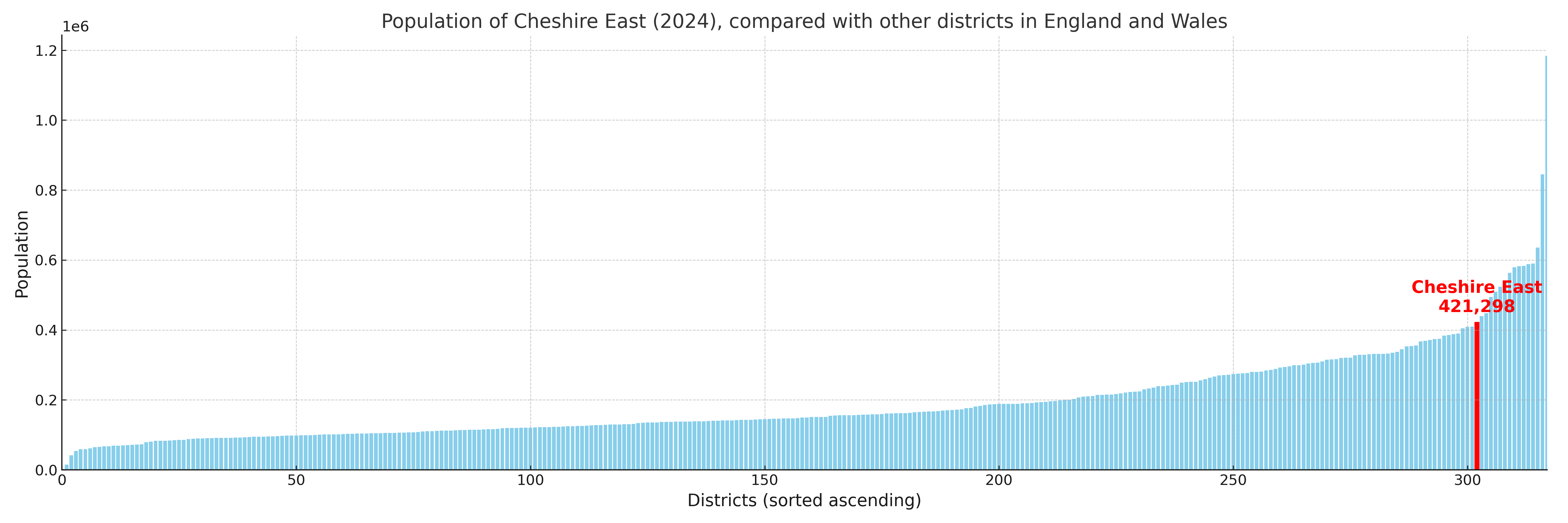
Cheshire East compared with other districts in the UK
This section shows how Cheshire East compares with other local authority districts in the UK, using a variety of measures and rankings.
Cheshire East has 52 electoral wards.

Cheshire East has a population of 421,298 (2024 mid-year estimate by ONS)
Population and Migration Trends in Cheshire East
This chart shows the population trend for Cheshire East from 2015 to 2024. It provides a quick overview of whether the local authority is growing, stable, or declining over time, and helps set context for the migration patterns shown below.
Population change is influenced by natural change (births minus deaths) and migration. The net migration chart below focuses on migration, separating internal migration (moves within the UK) from international migration (moves to and from abroad). Positive values indicate net inflows, while negative values indicate net outflows. The rate labels (per 1,000 residents) help compare migration intensity across years, even when the population size changes.
More local statistics and data for Cheshire East can be found on the ONS statistics for Cheshire East.
Latest news about Cheshire East
Use the search box, or suggested search phrases, below to find recent news, council updates, planning stories, housing developments, transport changes, public services news, local elections, community issues and other local developments related to Cheshire East. Results may include coverage from UK national, regional and local news websites, as well as official public-sector and local democracy sources.
- Cheshire East council
- Cheshire East planning
- Cheshire East local elections
- Cheshire East housing
- Cheshire East transport
- Cheshire East regeneration
- Cheshire East public services