Manchester
§ This page gives an overview of the Manchester local authority district, bringing together key facts, maps, and data to help you quickly understand the area. This is one of 361 LAD profiles on Baseview.
Overview ⁞ Manchester is a major city in North West England, famed for its industrial heritage, vibrant cultural scene, and iconic architecture. The city centre features landmarks such as Manchester Cathedral, the Town Hall in Albert Square, and modern developments like MediaCityUK and the Beetham Tower. The River Irwell and canals weave through historic warehouses now converted into apartments, galleries, and bars. Manchester is known for its music and sporting heritage, with venues like the AO Arena, Old Trafford, and Etihad Stadium. Green spaces include Heaton Park, one of Europe’s largest municipal parks, while surrounding neighbourhoods each bring distinctive character, from the Northern Quarter’s creativity to Didsbury’s leafy charm.
Manchester Boundary Map
This map shows the official boundary of the Manchester local authority district, based on the latest geographic data published by the Office for National Statistics (ONS). It provides a clear view of the district’s extent and helps you understand how the area fits within the wider regional and national landscape.
Contains OS data © Crown copyright and database right 2025. Source: Office for National Statistics licensed under the Open Government Licence v3.0.
The administrative boundary of Manchester can also be viewed on OpenStreetMap: District Boundary of Manchester.
Key Facts about Manchester
What region is Manchester in? Manchester is in the North West of England, a region within the UK.
What county is Manchester in? Manchester is located in the county of Greater Manchester.
Is Manchester a city? Yes, Manchester is a city. Manchester holds official city status as one of the 76 designated cities in the UK.
Who governs Manchester? The local government for this district is: Manchester City Council (Metropolitan District).
▶ Official website of Manchester City Council 🔗 manchester.gov.uk
Which police force covers Manchester? Policing in Manchester is provided by Greater Manchester Police 🔗 gmp.police.uk, which serves 10 local authority districts: Bolton ⁞ Bury ⁞ Manchester ⁞ Oldham ⁞ Rochdale ⁞ Salford ⁞ Stockport ⁞ Tameside ⁞ Trafford ⁞ Wigan.
Manchester in International Geographies
In the International Territorial Levels (ITLs) hierarchy, Manchester is within one of ITLs Level 2 area, Greater Manchester, that contains the following 5 ITLs Level 3 areas:
(ITL 1) North West
(ITL 2) ⇒ Greater Manchester
(ITL 3) ⇒⇒ Manchester ⁞ Greater Manchester South West ⁞ Greater Manchester South East ⁞ Greater Manchester North West ⁞ Greater Manchester North East
The International Territorial Levels are used by OECD member countries for statistical purposes to classify administrative areas. We have this listable page for easy browsing of ITL names and codes: International Territorial Levels.
Constituencies in Manchester
Manchester is divided into 6 parliamentary constituencies, listed below in alphabetical order.
- Blackley and Middleton South
- Gorton and Denton
- Manchester Central
- Manchester Rusholme
- Manchester Withington
- Wythenshawe and Sale East
A constituency is a specific geographical area that elects one Member of Parliament (MP) to represent them in the House of Commons. The United Kingdom is divided into 650 parliamentary constituencies. We have this list page for easy browsing of all UK parliamentary constituencies: List of Constituencies.
Wards in Manchester
Manchester is divided into 32 wards, listed below in alphabetical order.
- Ancoats & Beswick
- Ardwick
- Baguley
- Brooklands
- Burnage
- Charlestown
- Cheetham
- Chorlton
- Chorlton Park
- Clayton & Openshaw
- Crumpsall
- Deansgate
- Didsbury East
- Didsbury West
- Fallowfield
- Gorton & Abbey Hey
- Harpurhey
- Higher Blackley
- Hulme
- Levenshulme
- Longsight
- Miles Platting & Newton Heath
- Moss Side
- Moston
- Northenden
- Old Moat
- Piccadilly
- Rusholme
- Sharston
- Whalley Range
- Withington
- Woodhouse Park
In the UK, a ward is a subdivision of a local authority area, used mainly for electoral and statistical purposes. Defined by the ONS, wards represent the primary unit for local elections, each returning one or more councillors to the local council. Wards are also used as a key geography for presenting population and census data. We have this list page for easy browsing of all electoral wards: List of all Electoral Wards in the UK.
Parishes in Manchester
Manchester is part-parished: 1 civil parishes (listed A-Z below) alongside 7 unparished areas.
- Ringway
A civil parish is the lowest tier of local government in England, used for villages, small towns, and suburbs. They have their own local authority, either a parish council or a parish meeting, which provides local services like managing parks, allotments, and streetlights, and represents the community's views to larger councils.
We have this list page for easy browsing of all parishes: List of Civil Parishes in England and Wales.
Post Towns in Manchester
Below is a list of post towns in Manchester, grouped by postcode area:
M ▸ Manchester (M1 / M2 / M3 / M4 / M8 / M9 / M11 / M12 / M13 / M14 / M15 / M16 / M17 / M18 / M19 / M20 / M21 / M22 / M23 / M24 / M25 / M26 / M27 / M28 / M29 / M30 / M31 / M32 / M34 / M35 / M38 / M40 / M41 / M43 / M44 / M45 / M46 / M60 / M61 / M90 / M99)
The UK postal hierarchy begins with broad postcode areas (such as “CB” or “M”), which are divided into smaller postcode districts (such as “CB8” or “M1”) to support accurate mail routing. Each postal address is anchored by a designated post town, the official locality name used in the UK postcode system, which operates independently from Local Authority Districts —the administrative boundaries used for council tax and local government services. Because they serve different purposes, a property’s postal address and its local authority district do not always align exactly.
Built-up Areas in Manchester
Manchester covers 19 built-up areas, listed below in alphabetical order.
- Altrincham *
- Audenshaw *
- Chadderton *
- Denton (Tameside) *
- Droylsden *
- Failsworth *
- Gatley *
- Hale (Trafford) *
- Manchester *
- Middleton (Rochdale) *
- Old Trafford *
- Prestwich *
- Reddish *
- Rhodes *
- Sale *
- Salford *
- Stockport *
- Stretford *
- Wythenshawe *
In the UK, a Built-up Area (BUA) is a continuous urban area of at least 20 hectares (0.2 km²), defined by the ONS as land where buildings are generally no more than 200 metres apart, such as towns, cities, or large villages. (Note: A BUA name marked with an asterisk (*) indicates that the area is situated partly in the district of Manchester.)
We have this list page for easy browsing of all built-up areas: List of all Built-up Areas in GB.
Railway Stations in Manchester
Manchester is served by a number of National Rail stations, providing rail connections to nearby towns, cities, and destinations across Great Britain. The railway stations listed below are located within the Manchester Local Authority District and are grouped by train operating company for clarity.
- Network Rail ▸ Manchester Piccadilly (M60 7RA)
- Northern Trains ▸ Manchester Victoria (M3 1WY) ⁞ Manchester Oxford Road (M1 6FU) ⁞ Deansgate (M3 4LG) ⁞ Levenshulme (M19 3PJ) ⁞ Mauldeth Road (M14 6SQ) ⁞ East Didsbury (M20 5WP) ⁞ Burnage (M20 6FJ) ⁞ Moston (M40 0JT) ⁞ Ashburys (M12 5BY) ⁞ Gorton (M18 8QU) ⁞ Ryder Brow (M18 7EP) ⁞ Belle Vue (M18 1AA) ⁞ Ardwick (M12 6LY)
- TransPennine Express ▸ Manchester Airport (M90 3RR)
This is a district-level view only. For a complete list of all National Rail stations across Great Britain, see the UK National Rail Stations Directory.
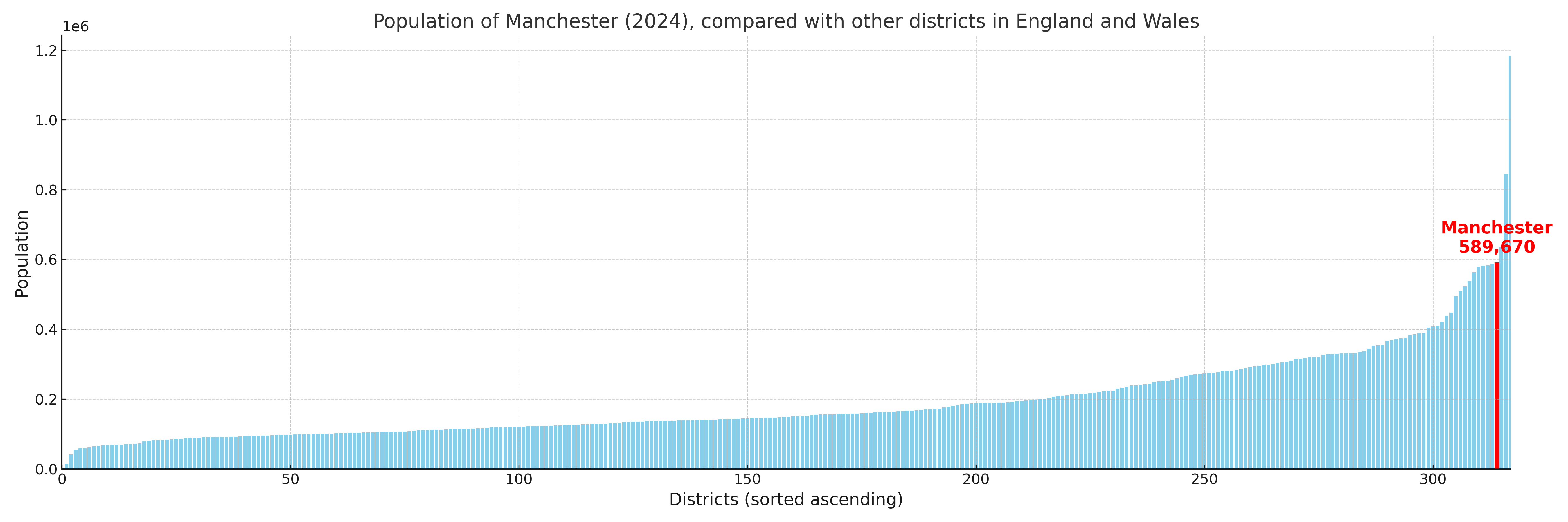
Manchester compared with other districts in the UK
This section shows how Manchester compares with other local authority districts in the UK, using a variety of measures and rankings.
Manchester has 32 electoral wards.

Manchester has a population of 589,670 (2024 mid-year estimate by ONS)
Population and Migration Trends in Manchester
This chart shows the population trend for Manchester from 2015 to 2024. It provides a quick overview of whether the local authority is growing, stable, or declining over time, and helps set context for the migration patterns shown below.
Population change is influenced by natural change (births minus deaths) and migration. The net migration chart below focuses on migration, separating internal migration (moves within the UK) from international migration (moves to and from abroad). Positive values indicate net inflows, while negative values indicate net outflows. The rate labels (per 1,000 residents) help compare migration intensity across years, even when the population size changes.
More local statistics and data for Manchester can be found on the ONS statistics for Manchester.
Latest news about Manchester
Use the search box, or suggested search phrases, below to find recent news, council updates, planning stories, housing developments, transport changes, public services news, local elections, community issues and other local developments related to Manchester. Results may include coverage from UK national, regional and local news websites, as well as official public-sector and local democracy sources.
- Manchester council
- Manchester planning
- Manchester local elections
- Manchester housing
- Manchester transport
- Manchester regeneration
- Manchester public services