Cumberland
§ This page gives an overview of the Cumberland local authority district, bringing together key facts, maps, and data to help you quickly understand the area. This is one of 361 LAD profiles on Baseview.
Overview ⁞ Cumberland covers the western part of Cumbria, stretching from the Lake District mountains to the Irish Sea coast. Carlisle is the main city, with its medieval castle, cathedral, and proximity to Hadrian’s Wall. The Lake District National Park extends into the district, including mountains like Skiddaw, lakes such as Bassenthwaite and Derwentwater, and towns like Keswick, a hub for walking and outdoor pursuits. The Solway Firth and coastal towns such as Workington, Whitehaven, and Maryport provide maritime character, while inland valleys and fells highlight dramatic scenery. Cumberland’s geography blends coast, mountains, rivers, and historic settlements in one of England’s most diverse landscapes.
Cumberland Boundary Map
This map shows the official boundary of the Cumberland local authority district, based on the latest geographic data published by the Office for National Statistics (ONS). It provides a clear view of the district’s extent and helps you understand how the area fits within the wider regional and national landscape.
Contains OS data © Crown copyright and database right 2025. Source: Office for National Statistics licensed under the Open Government Licence v3.0.
The administrative boundary of Cumberland can also be viewed on OpenStreetMap: District Boundary of Cumberland.
Key Facts about Cumberland
What region is Cumberland in? Cumberland is in the North West of England, a region within the UK.
What county is Cumberland in? Cumberland is in the county of Cumbria.
Is Cumberland a city? Yes, Cumberland is a city. Cumberland holds official city status as one of the 76 designated cities in the UK.
Who governs Cumberland? The local government for this district is: Cumberland Council (Unitary Authority).
▶ Official website of Cumberland Council 🔗 cumberland.gov.uk
Which police force covers Cumberland? Policing in Cumberland is provided by Cumbria Constabulary 🔗 cumbria.police.uk, which serves 2 local authority districts: Cumberland ⁞ Westmorland and Furness.
Cumberland in International Geographies
In the International Territorial Levels (ITLs) hierarchy, Cumberland is an ITLs Level 3 area:
- (ITL 1) North West
- (ITL 2) ⇒ Cumbria
- (ITL 3) ⇒⇒ Cumberland
The International Territorial Levels are used by OECD member countries for statistical purposes to classify administrative areas. We have this listable page for easy browsing of ITL names and codes: International Territorial Levels.
Constituencies in Cumberland
Cumberland is divided into 4 parliamentary constituencies, listed below in alphabetical order.
A constituency is a specific geographical area that elects one Member of Parliament (MP) to represent them in the House of Commons. The United Kingdom is divided into 650 parliamentary constituencies. We have this list page for easy browsing of all UK parliamentary constituencies: List of Constituencies.
Wards in Cumberland
Cumberland is divided into 46 wards, listed below in alphabetical order.
- Aspatria
- Belah
- Belle Vue
- Botcherby
- Bothel and Wharrels
- Brampton
- Bransty
- Castle
- Cleator Moor East and Frizington
- Cleator Moor West
- Cockermouth North
- Cockermouth South
- Corby and Hayton
- Currock
- Dalston and Burgh
- Dearham and Broughton
- Denton Holme
- Egremont
- Egremont North and St Bees
- Gosforth
- Harraby North
- Harraby South
- Harrington
- Hillcrest and Hensingham
- Houghton and Irthington
- Howgate
- Kells and Sandwith
- Keswick
- Longtown
- Maryport North
- Maryport South
- Millom
- Millom Without
- Mirehouse
- Morton
- Moss Bay and Moorclose
- Seaton
- Solway Coast
- St John's and Great Clifton
- St Michael's
- Stanwix Urban
- Thursby
- Upperby
- Wetheral
- Wigton
- Yewdale
In the UK, a ward is a subdivision of a local authority area, used mainly for electoral and statistical purposes. Defined by the ONS, wards represent the primary unit for local elections, each returning one or more councillors to the local council. Wards are also used as a key geography for presenting population and census data. We have this list page for easy browsing of all electoral wards: List of all Electoral Wards in the UK.
Parishes in Cumberland
Cumberland is part-parished: 128 civil parishes (listed A-Z below) alongside 1 unparished areas.
- Above Derwent
- Aikton
- Allhallows
- Allonby
- Arlecdon and Frizington
- Arthuret
- Askerton
- Aspatria
- Bassenthwaite
- Beaumont
- Beckermet
- Bewaldeth and Snittlegarth
- Bewcastle
- Blennerhasset and Torpenhow
- Blindbothel
- Blindcrake
- Boltons
- Bootle
- Borrowdale
- Bothel and Threapland
- Bowness
- Brampton
- Bridekirk
- Brigham
- Bromfield
- Broughton
- Broughton Moor
- Burgh by Sands
- Burtholme
- Buttermere
- Caldbeck
- Camerton
- Carlatton
- Castle Carrock
- Cleator Moor
- Cockermouth
- Crosscanonby
- Cummersdale
- Cumrew
- Cumwhitton
- Dalston
- Dean
- Dearham
- Distington
- Drigg and Carleton
- Dundraw
- Egremont
- Embleton
- Ennerdale and Kinniside
- Eskdale
- Farlam
- Gilcrux
- Gosforth
- Great Clifton
- Greysouthen
- Haile
- Hayton
- Hayton and Mealo
- Hethersgill
- Holme Abbey
- Holme East Waver
- Holme Low
- Holme St Cuthbert
- Ireby and Uldale
- Irthington
- Irton with Santon
- Keswick
- Kingmoor
- Kingwater
- Kirkandrews
- Kirkbampton
- Kirkbride
- Kirklinton Middle
- Lamplugh
- Lands common to Holme Abbey, Holme Low and Holme St Cuthbert
- Little Clifton
- Lorton
- Lowca
- Loweswater
- Lowside Quarter
- Maryport
- Midgeholme
- Millom
- Millom Without
- Moresby
- Muncaster
- Nether Denton
- Nicholforest
- Orton
- Oughterside and Allerby
- Papcastle
- Parton
- Plumbland
- Ponsonby
- Rockcliffe
- Scaleby
- Seascale
- Seaton
- Sebergham
- Setmurthy
- Silloth-on-Solway
- Solport
- St Cuthbert Without
- St John's Castlerigg and Wythburn
- St. Bees
- Stanwix Rural
- Stapleton
- Thursby
- Ulpha
- Underskiddaw
- Upper Denton
- Waberthwaite
- Walton
- Wasdale
- Waterhead
- Waverton
- Weddicar
- Westlinton
- Westnewton
- Westward
- Wetheral
- Whicham
- Whitehaven
- Wigton
- Winscales
- Woodside
- Workington
- Wythop
A civil parish is the lowest tier of local government in England, used for villages, small towns, and suburbs. They have their own local authority, either a parish council or a parish meeting, which provides local services like managing parks, allotments, and streetlights, and represents the community's views to larger councils.
We have this list page for easy browsing of all parishes: List of Civil Parishes in England and Wales.
Post Towns in Cumberland
Below is a list of post towns in Cumberland, grouped by postcode area:
- CA ▸ Beckermet (CA21) ⁞ Brampton (CA8) ⁞ Carlisle (CA1 / CA2 / CA3 / CA4 / CA5 / CA6 / CA99) ⁞ Cleator (CA23) ⁞ Cleator Moor (CA25) ⁞ Cockermouth (CA13) ⁞ Egremont (CA22) ⁞ Frizington (CA26) ⁞ Holmrook (CA19) ⁞ Keswick (CA12) ⁞ Maryport (CA15) ⁞ Moor Row (CA24) ⁞ Ravenglass (CA18) ⁞ Seascale (CA20) ⁞ St. Bees (CA27) ⁞ Whitehaven (CA28) ⁞ Wigton (CA7) ⁞ Workington (CA14 / CA95)
- LA ▸ Millom (LA18 / LA19)
The UK postal hierarchy begins with broad postcode areas (such as “CB” or “M”), which are divided into smaller postcode districts (such as “CB8” or “M1”) to support accurate mail routing. Each postal address is anchored by a designated post town, the official locality name used in the UK postcode system, which operates independently from Local Authority Districts —the administrative boundaries used for council tax and local government services. Because they serve different purposes, a property’s postal address and its local authority district do not always align exactly.
Built-up Areas in Cumberland
Cumberland covers 72 built-up areas, listed below in alphabetical order.
- Abbeytown
- Allonby
- Arlecdon
- Aspatria
- Beckermet
- Bigrigg
- Blackbank
- Blackwell (Carlisle)
- Bootle (Copeland)
- Bothel
- Braithwaite
- Brampton (Carlisle)
- Brigham
- Broughton Moor
- Burgh by Sands
- Caldbeck
- Cargo
- Carlisle
- Cleator Moor
- Cockermouth
- Crosby (Allerdale)
- Cumwhinton
- Dalston
- Dearham
- Distington
- Dovenby
- Egremont
- Flimby
- Frizington
- Gilsland *
- Gosforth
- Great Broughton and Little Broughton
- Great Clifton
- Greysouthen
- Harker
- Haverigg
- Hayton (Carlisle)
- Heads Nook
- High Harrington
- Houghton (Carlisle)
- Howbeck
- Keswick
- Kirkbride
- Longtown
- Lowca
- Maryport
- Millom
- Moor Row
- Moresby Parks
- Oldwall
- Parton
- Portinscale
- Redmain
- Rheda Park
- Scotby
- Seascale
- Seaton (Allerdale)
- Sellafield
- Siddick
- Silloth
- Skinburness
- St Bees
- Stainburn
- Tallentire
- Thornhill (Copeland)
- Thursby
- Warwick Bridge
- Wetheral
- Whitehaven
- Wigton
- Winscales
- Workington
In the UK, a Built-up Area (BUA) is a continuous urban area of at least 20 hectares (0.2 km²), defined by the ONS as land where buildings are generally no more than 200 metres apart, such as towns, cities, or large villages. (Note: A BUA name marked with an asterisk (*) indicates that the area is situated partly in the district of Cumberland.)
We have this list page for easy browsing of all built-up areas: List of all Built-up Areas in GB.
Railway Stations in Cumberland
Cumberland is served by a number of National Rail stations, providing rail connections to nearby towns, cities, and destinations across Great Britain. The railway stations listed below are located within the Cumberland Local Authority District and are grouped by train operating company for clarity.
- Avanti West Coast ▸ Carlisle (CA1 1QZ)
- Northern Trains ▸ Whitehaven (CA28 6AX) ⁞ Workington (CA14 2UZ) ⁞ Sellafield (CA20 1RG) ⁞ Millom (LA18 4AY) ⁞ Maryport (CA15 6DA) ⁞ St Bees (CA27 0BZ) ⁞ Corkickle (CA28 8AP) ⁞ Wigton (CA7 9BA) ⁞ Dalston (Cumbria) (CA5 7LT) ⁞ Wetheral (CA4 8JP) ⁞ Seascale (CA20 1QL) ⁞ Ravenglass for Eskdale (CA18 1SW) ⁞ Harrington (CA14 5QQ) ⁞ Aspatria (CA7 2AW) ⁞ Flimby (CA15 8QN) ⁞ Brampton (Cumbria) (CA8 1HW) ⁞ Bootle (Cumbria) (LA19 5TA) ⁞ Parton (CA28 6PA) ⁞ Silecroft (LA18 5LP) ⁞ Green Road (LA18 5HR) ⁞ Drigg (CA19 1XW) ⁞ Braystones (CA21 2YW) ⁞ Nethertown (CA22 2UG)
This is a district-level view only. For a complete list of all National Rail stations across Great Britain, see the UK National Rail Stations Directory.
Cumberland compared with other districts in the UK
This section shows how Cumberland compares with other local authority districts in the UK, using a variety of measures and rankings.
Cumberland has 46 electoral wards.

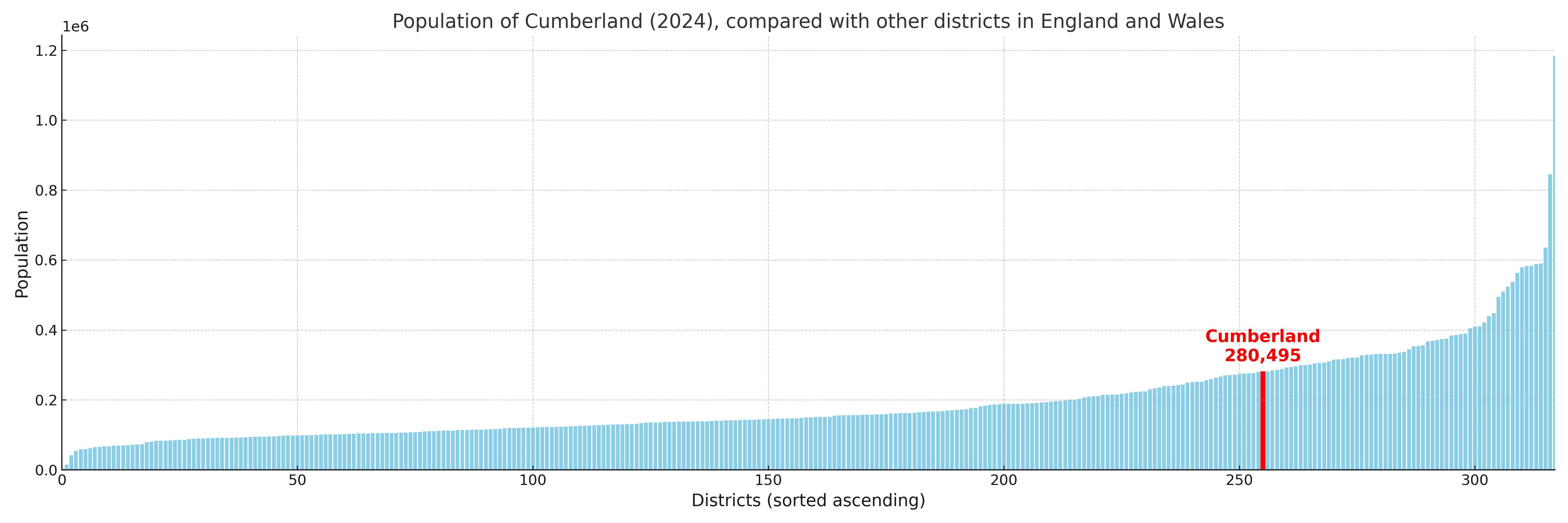
Cumberland has a population of 280,495 (2024 mid-year estimate by ONS)
Population and Migration Trends in Cumberland
This chart shows the population trend for Cumberland from 2015 to 2024. It provides a quick overview of whether the local authority is growing, stable, or declining over time, and helps set context for the migration patterns shown below.
Population change is influenced by natural change (births minus deaths) and migration. The net migration chart below focuses on migration, separating internal migration (moves within the UK) from international migration (moves to and from abroad). Positive values indicate net inflows, while negative values indicate net outflows. The rate labels (per 1,000 residents) help compare migration intensity across years, even when the population size changes.
More local statistics and data for Cumberland can be found on the ONS statistics for Cumberland.
Latest news about Cumberland
Use the search box, or suggested search phrases, below to find recent news, council updates, planning stories, housing developments, transport changes, public services news, local elections, community issues and other local developments related to Cumberland. Results may include coverage from UK national, regional and local news websites, as well as official public-sector and local democracy sources.
- Cumberland council
- Cumberland planning
- Cumberland local elections
- Cumberland housing
- Cumberland transport
- Cumberland regeneration
- Cumberland public services